Showing posts with label ENSO. Show all posts

Tuesday, October 20, 2026

Will 2026 El Nino cause Antarctic Blue Ocean Event?


The above image shows a record high sea surface temperature in the Niño 3.4 region of 30.21°C on October 25, 2026, 4.46°C higher than the 25.75°C recorded on January 9, 2026, and a record high anomaly of +3.6°C versus 1982-2010.

The map (inset at the bottom of the above image) shows sea surface temperature anomalies versus 1991-2020 on October 25, 2026, around the globe, with the Niño 3.4 region highlighted.

Temperature anomalies in the Niño 3.4 region are indicative of El Niño's strength. The 2015/2016 El Niño reached its peak strength late 2015. Similarly, the 2023/2024 El Niño reached its peak strength late 2023, as indicated by the grey square on the thick grey line on the above image. 


In the above image, issued by NOAA on October 19, 2026, the 2026/2027 El Niño doesn't yet show up, but it is forecast to reach peak strength late 2026, as illustrated by the image below.

[ image from earlier post ]
Strong melting of Antarctic sea ice typically occurs around the end of the year, so this year this is forecast to coincide with the strongest El Niño on record reaching peak strength.

Teleconnections

Air temperatures in the Tropics are high. The image below shows surface air temperatures in the Tropics through October 24, 2026, when the temperature in the Tropics was 26.52°C, an anomaly of 1.42°C versus 1979-2000, the highest anomaly on record. The globe (inset top left) shows the surface air temperature anomaly versus 1991-2020 on October 24, 2026, with the Tropics highlighted.


The image below, a forecast for October 29, 2026, shows atmospheric rivers carrying hot and moist air toward the poles, resulting in snowfall over Antarctica, thickening the snow layer there, while making the Southern Ocean more saline and thus making Antarctica sea ice more susceptible to melting, as discussed in an earlier post.


The combination image below, adapted from ClimateReanalyzer.org, shows daily averages for October 29, 2026, illustrating the mechanism of how conditions contribute to making Antarctic sea ice more susceptible to melting. 


The above combination image illustrates: 1. high sea surface temperatures in the Pacific Ocean (top left) and 2. high as well as very low temperatures over Antarctica, in places below -50°C (top center), resulting in 3. a distorted Jet Stream path with strong wind over Antarctica (top right), and in 4. atmospheric rivers pushing warm and moist air toward Antarctica, resulting in high precipitable water standardized deviation over Antarctica (bottom left), 5. high precipitation (bottom center), and 6. increased snow depth (bottom right).

The combination image below, adapted from nullschool.net, shows 3-hour Precipitation Accumulation as high as 18.8 mm over Antarctica on October 29, 2026, at the green circle (left) and at the same time and place a relative humidity of 100% at the green circle (right).


Snowfall over Antarctica thickens the snow layer over Antarctica, which contributes to an increase in salinity of the surface of the Southern Ocean, and thus makes Antarctic sea ice more susceptible to melting. as discussed in earlier posts such as this one and illustrated by the image below, adapted from Silvano et al. (2025). 


Prospect of an Antarctic Blue Ocean Event

On October 27, 2026, the global sea ice extent was 23.39 million km², the second lowest extent for the time of year, as illustrated by the image below, adapted from ads.nipr.ac.jp/vishop. The global sea ice extent can be expected to fall strongly over the next few months, due to the change in seasons and due to the 2026 El Niño gaining in strength. The image also highlights the year 2023 and the year 2016, which was a strong El Niño year. The 2026 El Niño is forecast to be even stronger.


Since September 29, 2026, the Antarctic sea ice area has been the lowest on record for the day and the deviation from 1981-2010 has not been below -4σ, while the deviation was as low as -5.36σ on October 14, 2026, as illustrated by the image below. 

On October 30, 2026, Antarctic sea ice area was 11.74 million km², again the lowest area on record for that day, while the deviation was -4.30σ. The dark blue band in the middle indicates 1σ deviation from the 1981-2010 average, while the light blue shading indicates 5σ deviation. The year 2023 is highlighted in blue and the year 2022 in purple. 


The above image shows a steep decline of Antarctic sea ice area in late 2022. The image below shows that the Antarctic sea ice area continued to be very low in early 2023. The light blue shading on the image below indicates 3σ deviation. On February 22, 2023, Antarctic sea ice area was 1.09 million km², very close to the 1 million km² threshold when a Blue Ocean Event could be called, while the deviation from 1981-2010 on that day was 3.03σ. 


Importantly, there was no strong El Niño present when the Antarctic sea ice reached its record low area in 2023. Instead, in 2022 and early 2023, La Niña conditions were present. By contrast, the 2026 El Niño is forecast to be very strong, its peak strength is forecast to occur late 2026, and the El Niño is forecast to extend into early 2027.

Greenhouse gas concentrations keep rising

Meanwhile, concentrations of greenhouse gases keep rising at an accelerating pace. 

While emissions by people did accelerate since the start of the Industrial Revolution and even more recently, the rise in emission by people had already started thousands of years ago with growth in agriculture, herding of animals and associated deforestation, as discussed in earlier posts such as this one. 

The accelerating rise from 1750 to 2025 in methane, carbon dioxide and nitrous oxide is illustrated by the image on the right, created with IPCC and WMO data. The acceleration has been strongest for methane, which in 2025 had a concentration of 267% relative to 1750.  

Conclusion

The situation is dire and unacceptably dangerous, and the precautionary principle necessitates the danger to be acknowledged, while facilitating rapid, comprehensive and effective action to reduce the damage and to improve the outlook, where needed in combination with a Climate Emergency Declaration, as described in posts such as in this 2022 post and this 2025 post, and as discussed in the Climate Plan group.


The ClimatePlan by Sam Carana calls for implementation of sets of feebates, with fees imposed on sales of polluting products and the revenues from those fees used to fund rebates on cleaner alternatives. Sets of feebates are best implemented ASAP, separately and preferably locally, with disputes handled by Local People's Courts where randomly-chosen local residents deliver verdicts on whether policies confirm the weight of best-available science. Where needed, Climate Emergency Declarations can support progress.


Links

• Climate Reanalyzer
https://www.climatereanalyzer.org

• NOAA - ENSO: Recent Evolution, Current Status and Predictions
https://www.cpc.ncep.noaa.gov/products/analysis_monitoring/lanina/enso_evolution-status-fcsts-web.pdf

• Kevin Pluck - sea ice visuals
https://seaice.visuals.earth

• Japanese National Institute of Polar Research - Arctic and Antarctic Data archive System
https://earth.nullschool.net

• Rising surface salinity and declining sea ice: A new Southern Ocean state revealed by satellites - by Alessandro Silvano et al. (2025)
https://www.pnas.org/doi/full/10.1073/pnas.2500440122
discussed on facebook at:
https://www.facebook.com/groups/arcticnews/posts/10162876582119679

• Double Blue Ocean Event (2026)
https://arctic-news.blogspot.com/p/double-blue-ocean-event.html

• Double Blue Ocean Event 2026-2027? - update June 2026
https://arctic-news.blogspot.com/2026/06/double-blue-ocean-event-2026-2027-update.html

• Antarctic sea ice increasingly in danger (2026)
https://arctic-news.blogspot.com/2026/08/antarctic-sea-ice-increasingly-in-danger.html

• Antarctica (2026)
https://arctic-news.blogspot.com/p/antarctica.html

• When Will We Die? (2019)
https://arctic-news.blogspot.com/2019/06/when-will-we-die.html

• Extinction (2016)
https://arctic-news.blogspot.com/p/extinction.html

• Transforming Society (2022)
https://arctic-news.blogspot.com/2022/10/transforming-society.html

• Climate Plan (2019)
https://arctic-news.blogspot.com/p/climateplan.html

• The Climate Plan by Sam Carana (2026)
https://arctic-news.blogspot.com/p/the-climate-plan-by-sam-carana.html

• Climate Emergency Declaration (2023)
https://arctic-news.blogspot.com/p/climate-emergency-declaration.html


Tuesday, September 3, 2024

Cataclysmic Alignment threatens Climate Catastrophe

Sunspots In a cataclysmic alignment, the next El Niño threatens to develop while sunspots are higher than expected. Sunspots are expected to reach a peak in the current cycle in July 2025.

The image below (top part), adapted from NOAA, shows the observed values for the number of sunspots for cycle 25, through August 2024, as well as the values predicted by NOAA (red line).

[ click on images to enlarge ]
The above image (bottom part) shows the observed values for the F10.7cm radio flux for cycle 25, through August 2024, as well as the values predicted by NOAA (red line).

The observed values are much higher than predicted. If this trend continues, the rise in sunspots forcing from early 2020 to July 2025 may well make a difference of more than 0.25°C.

El Niño

High sunspots could line up with an upcoming El Niño and with further forcing by short-term variables, in a cataclysmic alignment that could push up the temperature enough to cause dramatic sea ice loss in the Arctic, resulting in runaway temperature rise by 2026.

ENSO-neutral conditions are currently present and a transition to La Niña is expected by September-November 2024, as illustrated by the image below, from an earlier post and adapted from NOAA. The La Niña may be short-lived and a transition to the next El Niño may occur in the course of 2025.


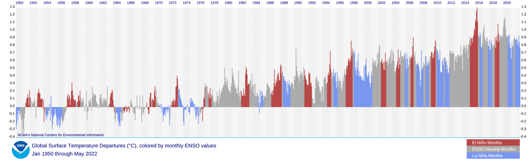
The image below, from an earlier post and adapted from NOAA, illustrates that El Niño conditions were present from June 2023 through April 2024, and that ENSO-neutral started in May 2024.


El Niño occurs every 2–7 years. The image shows that El Niño can occur as frequently as every two years, e.g. in 2002, 2004 and 2006. The danger is that we could move into a new El Niño in 2025, while temperatures remain high due to feedbacks and while sunspots move toward a peak in this cycle, expected to occur in July 2025.

This - in combination with further events, developments and short-term variables - could constitute a cataclysmic alignment that could result in runaway temperature rise by 2026, as an earlier post concluded. Moving from the bottom of a La Niña to the peak of a strong El Niño could make a difference of more than 0.5°C. Sunspots could make a difference of more than 0.25°C. Further forcing could be added by additional events, e.g. submarine volcano eruptions could add huge amounts of water vapor to the atmosphere.

Further forcing

Natural variability is mentioned by the IPCC, but because such events vary from year to year, their impact is smoothed out in climate change calculations that average the temperature rise over the course of decades. Yet, when such events coincide in a cataclysmic alignment, as could be the case within the next few years, the extra rise in temperature from - say - the year 2021 could be over 0.75°C. Note that this is an extra rise, on top of the long-term rise due to activities by people since pre-industrial.

Furthermore, as emissions and temperatures keep rising, such an extra rise could trigger feedbacks that threaten to grow in strength and strike with ever greater ferocity, further accelerating the temperature rise while extreme weather disasters hit numerous regions around the world more frequently over larger areas, with greater intensity and for longer periods.

Conflict and socio-economic stress could add further forcing. Heatwaves, fires, famine, drought, floods, crop loss, loss of habitable land and corrupt politicians threaten to cause violent conflicts to erupt around the world, industrial activity to grind to a halt and the temperature to rise above 3°C from pre-industrial, driving humans into extinction by 2026. Sadly, politicians and mainstream media fail to inform people about the danger, and once the full horror reveals itself, panic could be added to the problems the world faces.

Climate Emergency Declaration

The situation is dire and the precautionary principle calls for rapid, comprehensive and effective action to reduce the damage and to improve the situation, as described in this 2022 post, where needed in combination with a Climate Emergency Declaration, as discussed at this group.


Links

• NOAA - Space Weather Prediction Center
https://www.swpc.noaa.gov/products/solar-cycle-progression

• NOAA - Climate Prediction Center - ENSO: Recent Evolution, Current Status and Predictions
https://www.cpc.ncep.noaa.gov/products/analysis_monitoring/lanina/enso_evolution-status-fcsts-web.pdf

• NOAA - Monthly Temperature Anomalies Versus El Niño
https://www.ncei.noaa.gov/access/monitoring/monthly-report/global/202407/supplemental/page-4

• NOAA - El Niño/Southern Oscillation
https://www.ncei.noaa.gov/access/monitoring/enso

• Cataclysmic Alignment
https://arctic-news.blogspot.com/2022/06/cataclysmic-alignment.html

• Sunspots
https://arctic-news.blogspot.com/p/sunspots.html

• Pre-industrial
https://arctic-news.blogspot.com/p/pre-industrial.html

• Feedbacks
https://arctic-news.blogspot.com/p/feedbacks.html

• Jet Stream
https://arctic-news.blogspot.com/p/jet-stream.html

• Cold freshwater lid on North Atlantic
https://arctic-news.blogspot.com/p/cold-freshwater-lid-on-north-atlantic.html

• Transforming Society
https://arctic-news.blogspot.com/2022/10/transforming-society.html

• Climate Plan
https://arctic-news.blogspot.com/p/climateplan.html

• Climate Emergency Declaration
https://arctic-news.blogspot.com/p/climate-emergency-declaration.html


Sunday, June 5, 2022

Cataclysmic Alignment

Record high carbon dioxide

The concentration of carbon dioxide (CO₂) in the atmosphere recently broke two records at Mauna Loa, Hawaii, CO₂ was 421.63 in the week starting May 29, 2022, while CO₂ was 420.99 ppm in May 2022.


Earlier, very high daily and hourly measurements were recorded at Mauna Loa, as illustrated by the image below, showing one hourly measurement of 424 ppm (on May 28, 2022), as well as sequences of daily measurements in the green insets.


The image below shows carbon dioxide concentration rising over the past few years, with surface flask measurements well above 422 ppm at Mauna Loa recently.


Carbon dioxide concentration is even higher over the Arctic. The image below shows carbon dioxide approaching 430 ppm at Barrow, Alaska.


To get an idea how much greenhouse gases have risen, a 2021 study points at concentrations of 190 ppm for CO₂, 370-375 ppb for CH₄ and 200-245 ppb for N₂O some 18 ka to 21 ka. By comparison, the MetOp image below shows a global mean methane level of 1951 ppb, which is more than five times as high, while the image also shows a peak of 2405 ppb, at 293 mb on June 7, 2022 pm.  


The MetOp image below shows a lot of methane over the Arctic on May 30, 2022 pm, at 742 mb, which is much closer to sea level. 


The NOAA 20 image below shows high nitrous oxide levels over the Arctic on June 3, 2022 pm at 1000 mb.


Greenhouse gas levels are very high and there are many further indications that a huge temperature rise could take place over the next few years. 

Cataclysmic alignment of El Niño and sunspots 

The trigger for such a huge rise could be a cataclysmic alignment of the upcoming El Niño with a high number of sunspots, which look set to reach maximum impact around July 2025.

We are currently in the depths of a persistent La Niña, as illustrated by the image on the right, adapted from NOAA. This suppresses the temperature rise.

El Niños typically occur every 3 to 5 years, according to NOAA and as also illustrated by the NOAA image below, so the upcoming El Niño can be expected to occur soon.


The above NOAA image indicates that going from the bottom of a La Niña to the peak of an El Niño could make a difference of more than half a degree Celsius (0.5°C or 0.9°F). 

A huge temperature rise looks set to unfold soon, first of all in the Arctic, triggered by the combined impact of an upcoming El Niño and a peak in sunspots.
 
Sunspots are currently well above what NOAA predicted, as illustrated by the image on the right, adapted from NOAA. 

The more sunspot, the more the temperature goes up. The rise in sunspots from May 2020 to July 2025 could make a difference of some 0.15°C (0.27°F).

The next El Niño looks set to line up with a high peak in sunspots, in a cataclysmic alignment that could push up the temperature enough to cause dramatic sea ice loss in the Arctic, resulting in runaway temperature rise by 2026.

A huge temperature rise in the Arctic

There are many further indications that we're on the brink of a huge temperature rise in the Arctic.

Ocean heat that enters the Arctic Ocean from the Atlantic Ocean and the Pacific Ocean keeps rising.

[ see also more background at the Extinction page ]
As a result, several tipping points threaten to be crossed in the Arctic soon, as described in an earlier post, including the latent heat tipping point and a Blue Ocean Event (starting when Arctic sea ice extent will fall below 1 million km²), which would further speed up the temperature rise in the Arctic.

As temperatures keep rising in the Arctic, changes to the Jet Stream look set to intensify, resulting in loss of terrestrial albedo in the Arctic that could equal the albedo loss resulting from sea ice decline.

Further feedbacks include permafrost degradation, both terrestrial and on the seafloor of the Arctic Ocean, which looks set to cause huge releases of greenhouse gases (particularly CO₂, CH₄ and N₂O).

This would in turn also cause more water vapor to enter the atmosphere, further speeding up the temperature rise, especially in the Arctic, where vast amounts of methane are contained in sediments at the seafloor and where there is very little hydroxyl in the air to break down the methane.

Temperatures look set to rise further in the Arctic, due to falling away of sulfate aerosols, as illustrated by the IPCC image below that shows how much temperatures are currently suppressed in the Arctic due to aerosols and thus also shows how much temperatures in the Arctic look set to rise as the aerosol masking effect falls away.  

Conversely, there could be a temperature rise due to releases of other aerosols that have a net warming impact, such as black and brown carbon, which can increase dramatically as more wood burning, forest fires and urban fires take place, which again would hit the Arctic hard by darkening the surface as they settle on the snow and ice cover, thus speeding up its decline. 


Furthermore, the combined impact of aerosols and nitrogen fertilizers has been underestimated; a recent study concludes that when ammonia, nitric acid and sulfuric acid are present together, they contribute strongly to the formation of cirrus clouds. 

Global temperature rise

As the temperature keeps rising, further self-reinforcing feedbacks will kick in with more ferocity such as an increase in water vapor globally combined with a decrease in lower clouds decks, further increasing the temperature, as described at the clouds feedback page.

Altogether, the global temperature could rise by more than 18°C above pre-industrial, as illustrated by the image further above on the right, and as also discussed at the Extinction page.

Human extinction by 2025?

[ from earlier post ]
 
[ from earlier post ]
An April 2022 analysis found that the temperature rise from pre-industrial to March 2022 could be as much as 2.35°C. When adding 0.65°C for the joint impact of the upcoming El Niño and a peak in sunspots, the rise could be as much as 3°C by 2025, as also depicted in the image on the right, from that same analysis. 

A 2018 study (by Strona & Bradshaw) indicates that most life on Earth will disappear with a 5°C rise. Humans, who depend for their survival on many other species, will likely go extinct with a 3°C rise, as illustrated by the image below, from an earlier post.


Rise beyond 2026

As said, a temperature rise of 3°C from pre-industrial could be reached by 2025 just due to the combined push of the upcoming El Niño and a peak in sunspots, i.e. without change in other forcers.

What would happen if just methane kept rising, i.e. without change in other forcers? The image below shows methane with a trend added that points at a rise that could represent a forcing of 780 ppm CO₂e in 2028, which means that the clouds tipping point at 1200 ppm CO₂e would be crossed by methane and carbon dioxide alone (assuming no change in other forcers and with carbon dioxide remaining at 421 ppm), which would cause an additional 8°C rise in temperature. 


The above image shows that such a trend is contained in existing methane data. When also adding a large eruption of methane from the seafloor of the Arctic Ocean, the situation would be even worse, further underlining the potential for a rise of more than 18°C by 2026. 

Conclusion

In conclusion, temperatures could rise strongly soon, driving humans extinct as early as in 2025, while temperatures could skyrocket in 2026, making it in many respects rather futile to speculate about what will happen beyond 2026. At the same time, the right thing to do now is to help avoid the worst things from happening, through comprehensive and effective action as described in the Climate Plan.

In the video below, Jennifer Hynes and Sandy Schoelles discuss the situation.


Links

• NOAA - Global Monitoring Laboratory, Recent Daily Average CO₂ at Mauna Loa, Hawaii, U.S.
https://gml.noaa.gov/ccgg/trends

• NOAA - Global Monitoring Laboratory, at Barrow, Alaska, U.S.
https://gml.noaa.gov/dv/iadv/graph.php?code=BRW&program=ccgg&type=ts

• Globally resolved surface temperatures since the Last Glacial Maximum - by Matthew Osman et al. (2021)
https://www.nature.com/articles/s41586-021-03984-4

• Arctic Hit By Ten Tipping Points
https://arctic-news.blogspot.com/2020/04/arctic-hit-by-ten-tipping-points.html

• NOAA - ENSO: Recent Evolution, Current Status and Predictions
https://www.cpc.ncep.noaa.gov/products/analysis_monitoring/lanina/enso_evolution-status-fcsts-web.pdf

• NOAA - El Niño
https://www.noaa.gov/education/resource-collections/weather-atmosphere/el-nino#:~:text=An%20El%20Ni%C3%B1o%20condition%20occurs,every%203%20to%205%20years.

• NOAA - Monthly Temperature Anomalies Versus El Niño
https://www.ncei.noaa.gov/access/monitoring/monthly-report/global/202204/supplemental/page-4

• MetOp satellite
https://www.ospo.noaa.gov/Products/atmosphere/soundings/iasi

• NOAA 20 satellite
https://www.ospo.noaa.gov/Products/atmosphere/soundings/nucaps/NUCAPS_composite.html

• Ten temperature rise indications

• How ice clouds develop – Asian monsoon influences large parts of the Northern Hemisphere

• Synergistic HNO3 H2SO4 NH3 upper tropospheric particle formation - by Mingyi Wang et al. https://www.nature.com/articles/s41586-022-04605-4
discussed on facebook at: 
https://www.facebook.com/groups/arcticnews/posts/10160005189729679

• Clouds feedback and tipping point
https://arctic-news.blogspot.com/p/clouds-feedback.html

• Jet Stream
https://arctic-news.blogspot.com/p/jet-stream.html

• The Importance of Methane
https://arctic-news.blogspot.com/p/the-importance-of-methane-in-climate.html

• Pre-industrial

• Runaway temperature rise by 2026?
https://arctic-news.blogspot.com/2022/04/runaway-temperature-rise-by-2026.html

• Co-extinctions annihilate planetary life during extreme environmental change - by Giovanni Strona and Corey Bradshaw (2018) 


Wednesday, February 15, 2017

More heat on the way


Above image shows temperature anomalies over the Pacific Ocean on February 12, 2017. Note the 19.2°C (34.5 °F) anomaly off the coast of Japan, at the location marked by the green circle.

In 2016, the annually-averaged temperature for ocean surfaces around the world was 0.75°C (1.35°F) higher than the 20th century average, higher than the previous record of 2015, NOAA reports. The global annual land surface temperature for 2016 was 1.43°C (2.57°F) above the 20th century average, surpassing the previous record of 2015 by 0.11°C (0.19°F). Note that NOAA uses the the 20th century average as a baseline, for more on different baselines, see this earlier post.

There is more heat on the way, as illustrated by the image below.


As above image shows, the El Niño-Southern Oscillation (ENSO) temporarily raises (El Niño) or suppresses (La Niña) global temperatures. Generally, the stronger the event (El Niño or La Niña), the greater its impact on the average global temperature around that time. Note that one value for 2016 literally went off the chart.


As above image shows (at the end of the graph on the right), we've barely had a bit of a La Niña in 2017 and we're already facing another El Niño event.

[ click on images to enlarge ]

Above images shows ECMWF (European Centre for Medium-Range Weather Forecasts) plumes with strong positive anomalies in all three El Niño regions (on the right).

In other words, temperatures in 2017 look set to be very high, which spells bad news for the Arctic where temperature anomalies are already several times higher than in the rest of the world, as illustrated by the image below.

As the image below shows, Antarctic sea ice extent was at a record low for the time of the year on February 11, 2017.


The situation looks particularly grim for the Arctic sea ice. As the image below shows, Arctic sea ice extent on February 11, 2017, was also at a record low for the time of the year. In fact, it had fallen to 13,895,00 km² that day, raising the question whether perhaps the maximum for the year 2017 had already been reached.


Low global sea ice extent means that less sunlight is reflected back into space by the ice and that more heat is instead absorbed by the ocean, adding to the predicament the world is in. The situation in the Arctic is crucial, as huge amounts of methane, contained in sediments under the Arctic Ocean, could be released if warming continues, potentially triggering mass extinction of species, including humans, within one decade.

The situation is dire and calls for comprehensive and effective action as described in the Climate Plan.


Links


• Climate Plan
http://arctic-news.blogspot.com/p/climateplan.html

• Extinction
http://arctic-news.blogspot.com/p/extinction.html

• How much warming have humans caused?
http://arctic-news.blogspot.com/2016/05/how-much-warming-have-humans-caused.html

• Warning of mass extinction of species, including humans, within one decade
http://arctic-news.blogspot.com/2017/02/warning-of-mass-extinction-of-species-including-humans-within-one-decade.html