Temperatures as high as 125°F or 51.67°C are forecast to hit California on July 6, 2024, as illustrated by the image below, adapted from Climate Reanalyzer by the University of Maine.

On June 23, 2024, the temperature in the Northern Hemisphere was higher than it was last year at this time of year, as illustrated by the image below, created with University of Maine content. The image shows that a temperature of 21.5°C was reached in the Northern Hemisphere on June 23, 2024. The question is: Will temperatures over the next few months exceed the high temperatures reached last year?


Nonetheless, there are fears that temperatures will remain high and continue to rise, as self-amplifying feedbacks have taken over as the dominant drivers of the temperature rise. This was discussed earlier, in recent posts such as this one and this one.
There are numerous feedbacks that can further accelerate the temperature rise. Higher temperatures come with more water vapor in the atmosphere, an important feedback since water vapor is also a potent greenhouse gas.
Surface precipitable water reached a record high of 27.139 kg/m² in July 2023, as illustrated by the image below, adapted from NOAA, from an earlier post. Worryingly, a value of 26.138 kg/m² was reached in May 2024, much higher than the 25.378 kg/m² in May 2023, which raises fears that surface precipitable water will reach an even higher peak in 2024 than was reached in 2023.
Surface precipitable water reached a record high of 27.139 kg/m² in July 2023, as illustrated by the image below, adapted from NOAA, from an earlier post. Worryingly, a value of 26.138 kg/m² was reached in May 2024, much higher than the 25.378 kg/m² in May 2023, which raises fears that surface precipitable water will reach an even higher peak in 2024 than was reached in 2023.


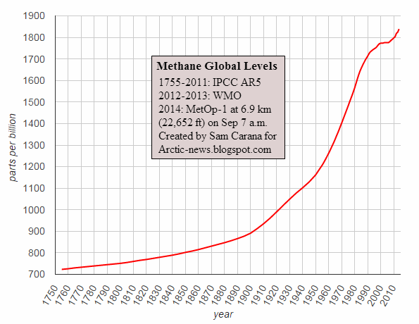
Rising temperatures speed up the decline of sea ice and permafrost, which can in turn result in huge emissions of carbon dioxide, methane and nitrous oxide.
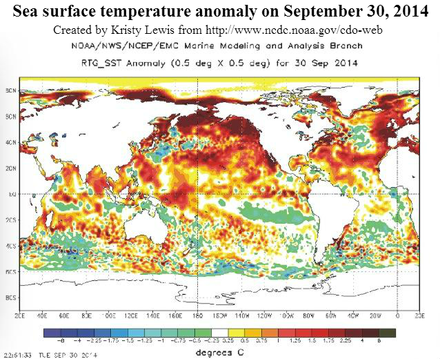
The decline of permafrost results in more meltwater that speeds up the flow of rivers. The image on the right shows sea surface temperatures as high as 18.3°C in the Bering Strait on June 29, 2024.
Deformation of the Jet Stream is another important feedback and it particularly affects the Northern Hemisphere where the Arctic heats up more rapidly than the rest of the world, thus narrowing the temperature difference between the Tropics and the Arctic, which changes the shape of the Jet Stream.
The Jet Stream will meander more and can at times even form circular wind patterns in some areas, which can strongly amplify extreme weather events such as storms that come with flooding and heatwaves that come with forest fires on land.
On land, more extreme weather can cause strong rainfall, resulting in more water running off into the Arctic Ocean. As heatwaves cause the water of rivers to heat up, a lot more heat can enter the Arctic Ocean.
Heatwaves and increased lightning can also cause fires that result in emissions and cause black carbon to settle on ice, causing temperature rise due to albedo loss and speeding up the thawing of permafrost and melting of sea ice. The image below, adapted from Copernicus, shows biomass burning aerosols, i.e. a forecast for June 29, 2024.
Heatwaves and increased lightning can also cause fires that result in emissions and cause black carbon to settle on ice, causing temperature rise due to albedo loss and speeding up the thawing of permafrost and melting of sea ice. The image below, adapted from Copernicus, shows biomass burning aerosols, i.e. a forecast for June 29, 2024.

Over oceans, the impact of deformation of the Jet Stream can be even larger, since wind tends to be stronger over oceans than over land. Near the ocean, the greater temperature difference between land and sea will result in stronger winds.
The image below shows sea surface temperatures in the Northern Hemisphere. Heavy melting occurs in the blue-colored areas. Where the sea ice has disappeared, red and yellow colors show up, indicating temperatures higher than they used to be at this time of year in the respective area. High anomalies result from the loss of the latent heat buffer that previously absorbed heat and from the albedo changes that result in more sunlight getting absorbed by the surface.

Furthermore, the image shows a deformed Jet Stream with many circular wind patterns (at 250 hPa) over the Arctic. Deformation of the Jet Stream contributes to these high temperatures, by enabling heatwaves to extend over the Arctic Ocean, increasing not only the intensity, but also the frequency, duration and areas covered by such events.
The above image shows sea surface temperatures as high as 8.2°C or 46.7°F (i.e. 4.5°C or 8.1°F higher than 1981-2011) in the Laptev Sea (at the green circle), illustrating how a deformed Jet Stream is moving hot air over the Arctic Ocean and is also heating up the water of the Lena River and accelerating the speed at which the water is flowing into the Arctic Ocean.

Deformation of the Jet Stream enables strong winds to develop over the North Atlantic, which can at times strongly accelerate the speed at which hot water is flowing toward the Arctic Ocean along path of the Gulf Stream.
A deformed Jet Stream can temporarily speed up this flow, causing huge amounts of ocean heat to get abruptly pushed into the Arctic Ocean in the path of the Gulf Stream.
The image on the right shows hot water getting pushed along the path of the Gulf Stream from the Gulf of Mexico toward the Arctic Ocean. The image shows sea surface temperatures as high as 32.3°C on June 22, 2024.


Climate Emergency Declaration
The situation is dire and the precautionary principle calls for rapid, comprehensive and effective action to reduce the damage and to improve the situation, as described in this 2022 post, where needed in combination with a Climate Emergency Declaration, as discussed at this group.

The image below shows sea surface temperatures in the Northern Hemisphere. Heavy melting occurs in the blue-colored areas. Where the sea ice has disappeared, red and yellow colors show up, indicating temperatures higher than they used to be at this time of year in the respective area. High anomalies result from the loss of the latent heat buffer that previously absorbed heat and from the albedo changes that result in more sunlight getting absorbed by the surface.

Furthermore, the image shows a deformed Jet Stream with many circular wind patterns (at 250 hPa) over the Arctic. Deformation of the Jet Stream contributes to these high temperatures, by enabling heatwaves to extend over the Arctic Ocean, increasing not only the intensity, but also the frequency, duration and areas covered by such events.
The above image shows sea surface temperatures as high as 8.2°C or 46.7°F (i.e. 4.5°C or 8.1°F higher than 1981-2011) in the Laptev Sea (at the green circle), illustrating how a deformed Jet Stream is moving hot air over the Arctic Ocean and is also heating up the water of the Lena River and accelerating the speed at which the water is flowing into the Arctic Ocean.
The image below shows sea surface temperatures as high as 15.4°C or 59.7°F (i.e. 14.9°C or 26.8°F higher than 1981-2011) in Hudson Bay (at the green circle), while a deformed Jet Stream is moving hot air from Siberia far over the Arctic Ocean.

 |
| [ click on images to enlarge ] |
As Arctic temperatures keep rising, two tipping points threaten to get crossed as temperatures rise and Arctic sea ice disappears, i.e. the latent heat tipping point and the seafloor methane tipping point, as discussed in an earlier post.
The combination image below, adapted from the University of Bremen, indicates that most of the thicker sea ice has melted in the course of June 2024, and that the latent heat buffer may be gone soon.
The combination image below, adapted from the University of Bremen, indicates that most of the thicker sea ice has melted in the course of June 2024, and that the latent heat buffer may be gone soon.

As illustrated by the image below, adapted from IRI, La Niña may develop during July-September 2024. A combination of feedbacks and their interaction, including the water vapor feedback, deformation of the Jet Stream and loss of albedo and loss of the latent heat buffer, may cause a continuation of high temperatures even during this La Niña. A new El Niño may develop in 2025 and be prevalent in 2026.

In other words, we may move into the next El Niño while the temperature rise keeps accelerating, while the masking effect of aerosols gets further reduced and while sunspots are moving toward a peak (in July 2025).
Climate Emergency Declaration
The situation is dire and the precautionary principle calls for rapid, comprehensive and effective action to reduce the damage and to improve the situation, as described in this 2022 post, where needed in combination with a Climate Emergency Declaration, as discussed at this group.

Links
• Climate Reanalyzer
https://climatereanalyzer.org
• Have feedbacks taken over?
https://arctic-news.blogspot.com/2024/06/have-feedbacks-taken-over.html
• Copernicus
https://atmosphere.copernicus.eu
• nullschool
https://earth.nullschool.net
• Feebacks in the Arctic
https://arctic-news.blogspot.com/p/feedbacks.html
• Jet Stream
https://arctic-news.blogspot.com/p/jet-stream.html
• University of Bremen - Arctic sea ice
https://seaice.uni-bremen.de/start
• Latent heat
https://arctic-news.blogspot.com/p/latent-heat.html
• Albedo
https://arctic-news.blogspot.com/p/albedo.html
• Two Tipping Points
https://arctic-news.blogspot.com/2023/08/two-tipping-points.html
• The International Research Institute for Climate and Society, Columbia University Climate School
https://iri.columbia.edu/our-expertise/climate/forecasts/enso/current/?enso_tab=enso-sst_table
• Sunspots
https://arctic-news.blogspot.com/p/sunspots.html
https://climatereanalyzer.org
• Arctic Sea Ice Alert
https://arctic-news.blogspot.com/2024/06/have-feedbacks-taken-over.html
• Copernicus
https://atmosphere.copernicus.eu
• nullschool
https://earth.nullschool.net
• Feebacks in the Arctic
https://arctic-news.blogspot.com/p/feedbacks.html
• Jet Stream
https://arctic-news.blogspot.com/p/jet-stream.html
• University of Bremen - Arctic sea ice
https://seaice.uni-bremen.de/start
• Latent heat
https://arctic-news.blogspot.com/p/latent-heat.html
• Albedo
https://arctic-news.blogspot.com/p/albedo.html
• Two Tipping Points
https://arctic-news.blogspot.com/2023/08/two-tipping-points.html
• The International Research Institute for Climate and Society, Columbia University Climate School
https://iri.columbia.edu/our-expertise/climate/forecasts/enso/current/?enso_tab=enso-sst_table
• Sunspots
https://arctic-news.blogspot.com/p/sunspots.html
• Aerosols
https://arctic-news.blogspot.com/p/aerosols.html
• Extinction
https://arctic-news.blogspot.com/p/extinction.html
• Climate Plan
https://arctic-news.blogspot.com/p/climateplan.html
• Transforming Society
https://arctic-news.blogspot.com/2022/10/transforming-society.html
• Climate Emergency Declaration
https://arctic-news.blogspot.com/p/climate-emergency-declaration.html