 |
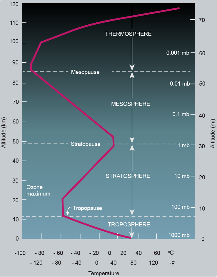
| [CC image, credit: nptel.ac.in ] |
2025
The image below shows temperatures as high as 6.1°C or 43.1°F forecast over Antarctica at 10 hPa for September 23, 2025. This would count as a Stratospheric Warming Event, since the temperature over Antarctica at 10 hPa is typically far below zero (see images right). During a Stratospheric Warming Event, heat rises up into the atmosphere, typically due to high surface temperature anomalies.


As illustrated by the image on the right, relative humidity as high as 37% is forecast over Antarctica for September 23, 2025, at 70 hPa, which is in the lower stratosphere corresponding with an altitude of approximately 20 km.
The stratosphere extends from roughly 10-50 km. The ozone layer is located in the lower stratosphere and water vapor reaching the stratosphere threatens to deplete ozone in the ozone layer.
As temperatures rise, the danger increases since a Sudden Stratospheric Warming event can come with water vapor moving into the stratosphere.
Furthermore, more water vapor gets into the air as temperatures rise. Also, the precipitable water standardized anomaly can rise strongly over both the Arctic and Antarctica, as illustrated by the combination image below, a nowcast for September 23, 2025.

A mild Stratospheric Warming Event took place in January 2014. On January 4, 2014 06:00 UTC, temperatures in the Stratosphere at 10 hPa were as high as -8.9°C or 16.1°F (at the green circle).

The event was followed by moistening of the Stratosphere, as illustrated by the image below. On January 25, 2014 06:00 UTC, relative humidity over the North Atlantic in the Stratosphere at 10 hPa was as high as 51% (at the green circle).

2016
On February 7, 2016 12:00 UTC, temperatures in the Stratosphere at 10 hPa were as high as 15°C or 58.9°F (at the green circle).

The event was accompanied by moistening of the Stratosphere, as illustrated by the image below. On February 8, 2016 09:00 UTC, relative humidity over the North Atlantic in the Stratosphere at 10 hPa was as high as 56% (at the green circle).

In December 2016, profound moistening of the Stratosphere over the Arctic took place. The image below shows 100% relative humidity over a large part of the Arctic in the Stratosphere at 10 hPa on December 19, 2016 00:00 UTC.

2017
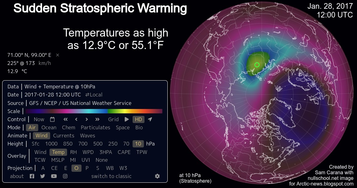
Temperatures were as high as 12.9°C or 55.1°F in the Stratosphere at 10 hPa on January 28, 2017 12:00 UTC.
The Sudden Stratospheric Warming events was accompanied by moistening of the Stratosphere over the North Atlantic. The image below shows a relative humidity as high as 54% in the Stratosphere at 10 hPa on January 29, 2017 12:00 UTC.

2018
The image below shows the situation on January 18, 2018, 15:00 UTC. The Polar Vortex has split into two parts, with one part centering over Bering Strait (left) and the other part centering over Fram Strait/Greenland (right), while the Polar Vortex is reaching speeds over the Arctic as high as 416 km/h or 259 mph (green circle).

The image below shows the situation on January 21, 2018. The Polar Vortex on the Northern Hemisphere has developed a third eye over the Mediterranean Sea and reaches speeds as high as 428 km/h or 266 mph over the North Sea. On the Southern Hemisphere, the Polar Vortex is located close to the Equator.

On February 9, 2018, four eyes were present, while the Polar Vortex reached speeds as high as 425 km/h or 263 mph over Greenland, reflecting increasingly extreme conditions due to global warming. Two images are added, the image below is a global projection.

In February 2018, a huge amount of heat had accumulated in the Arctic, as the NASA image below shows.


As illustrated by the image below, the 1-day area weighted 2 m temperature anomaly over the Arctic was 3.46°C on February 1, 2023.
The early 2023 Sudden Stratospheric Warming Event was preceded by moistening of the Stratosphere over the North Atlantic and the Arctic starting in November 2022. The image below shows relative humidity as high as 34% in the Stratosphere at 10 hPa on November 29, 2022 02:00 UTC.

The image below shows temperatures as high as 3.5°C or 38.2°F recorded in the Stratosphere (at 10 hPa, at the green circle) on February 14, 2023 15:00 UTC. The green area around the green circle shows temperatures above the freezing point of water (of 0°C).


Furthermore, global overheating causes the temperature of oceans to rise and this keeps air temperatures over water relatively high (compared with temperatures over land). This growing temperature difference between cold continents and hot oceans further strengthens the wind in Winter.
Global overheating is causing the wind to get stronger, while at the same time causing deformation of the Jet Stream, which at times can result in very cold air descending from the Arctic to North America and Eurasia. So, this can at times significantly bring down temperatures on land further.
Stronger wind and higher temperatures result in more evaporation. Strong wind can cause heat and water vapor to rise up high into the atmosphere, particularly from the North Atlantic Ocean and the Arctic Ocean, where sea surface temperature anomalies are very high. This can result in stratospheric phenomena such as a Sudden Stratospheric Warming event and moistening of the Stratosphere.
Such phenomena are rare and when they do occur, they will typically last only for a short time. The fact that Sudden Stratospheric Warming in 2023 is forecast to be extended over such a long period is worrying and reflects huge overheating of the Arctic Ocean.
A further associated temporary phenomenon is a cold snap at surface level that can follow such a strong rise of heat to higher altitudes.


 Following the massive amount of heat rising high up in the atmosphere, a temperature of -50.3°C (or -58.6°F) was recorded in Russia on January 21, 2025 (07:00 UTC), as illustrated by the image on the right and discussed here.
Deformation of the Jet Stream contributed to this situation, by enabling cold air to descend from the Arctic deep over continents and by enabling huge amounts of heat to get moved from the North Atlantic toward the North Pole, as illustrated by the combination image below.

• Arctic Ocean January 2020
https://arctic-news.blogspot.com/2020/02/arctic-ocean-february-2020.html
• Seismic Events
https://arctic-news.blogspot.com/p/seismic-events.html
• Methane, Earthquake and Sudden Stratospheric Warming
The image below shows the situation on January 18, 2018, 15:00 UTC. The Polar Vortex has split into two parts, with one part centering over Bering Strait (left) and the other part centering over Fram Strait/Greenland (right), while the Polar Vortex is reaching speeds over the Arctic as high as 416 km/h or 259 mph (green circle).


The image below shows the Northern Hemisphere (orthographic=90,90) on February 9, 2018, when the Polar Vortex was split up into four vortices. As said above, winds at 10 hPa reached speeds as fast as 425 km/h or 264 mph (at the green circles on the images above and below).
 |
| Polar Vortex split up into 4 vortices |

On February 16, 2018, the Polar Vortex has four eyes, with one eye centered over Alberta. The Polar Vortex reaches temperatures as high as 8.9°C or 47.9°F over Hudson Bay, and as low as -69.1°C or -92.5°F over the Pacific and -69.8°C or -93.6°F over the Atlantic. This huge temperature difference makes winds over Yukon Territory reach speeds as high as 328 km/h or 204 mph.
The image below shows Sudden Stratospheric Warming on February 16, 2018, when the Polar Vortex had split up into four vortices, as the Sudden Stratospheric Warming event unfolded.

Following the event, an atmospheric river of heat reached the North Pole; temperatures were as high as 1.1°C or 34.1°F on February 25, 2018, as illustrated by the image below.

The images below further illustrate the huge amount of heat that entered the Arctic from the south. Temperatures above 6°C were registered at Kap Morris Jesup, Greenland's northernmost weather station, on February 25, 2018.


Worryingly, very high methane releases followed this chain of events, likely originating from the seafloor of the East Siberian Arctic Shelf (ESAS), as discussed in the post Warning Signs.


 On the morning of March 12, 2020, peak methane levels were as high as 2902 ppb (parts per billion) at a pressure level of 469 mb (millibar, equivalent to an altitude of some 6 km (almost 20,000 feet).
 What did cause this very high peak? The image on the right shows the situation at 695 mb.
High levels of methane, colored in magenta, show up over the oceans at high latitudes north, especially around Greenland and around Svalbard.
The image underneath on the right shows methane even closer to sea level, at 1000 mb. At this altitude, such magenta-colored high levels of methane only show up over an area in between Greenland and Svalbard.
It appears that these high methane levels did originate from this area. What could have triggered this?
The image below shows that an earthquake with a magnitude of 4.8 on the Richter scale hit an area in between Greenland and Svalbard on March 11, 2020, at 21:30:03 (UTC), 2020, at depth of 10 km.

It appears that the earthquake did cause destabilization of sediments at the seafloor of the Arctic Ocean in between Greenland and Svalbard, containing methane in the form of hydrates and free gas, with the destabilization resulting in the eruption of methane that subsequently reached the atmosphere.
 The image on the right shows strong difference in pressure in the atmosphere over Greenland and over the Arctic Ocean on March 11, 2020, 21:00 UTC.
The next question is if there was something that triggered the earthquake.
The image below shows a forecast for March 22, 2020, of conditions in the stratosphere at 10 hPa.
Temperatures as high as 6.2°C or 43.2°F are forecast, and as low as -68.8°C or -91.9°F at another location, with wind reaching speeds as high as 369 km/h or 229 mph.

 This indicates a strong updraft, carrying huge amounts of relatively warm air from low altitudes over the Arctic up into the stratosphere.
While Arctic sea ice extent is a bit larger than it was in previous years at this time of year, sea ice thickness is at a record low for the time of year.
These conditions may have acted as a sink plunger, triggering the earthquake and destabilizing sediments at the seafloor, resulting in the methane eruptions.
More generally, the events reflect a huge and growing overall imbalance in the temperature of the atmosphere, with the added methane releases further contributing to this imbalance.
The maps on the right show what happened later in 2020, and in February 2021.


As the Climate Reanalyzer forecast below shows, the 2 m temperature anomaly was forecast to be very high for an area over the Arctic Ocean north of Siberia for January 24, 2023 00:00 UTC.
The image below shows Sudden Stratospheric Warming on February 16, 2018, when the Polar Vortex had split up into four vortices, as the Sudden Stratospheric Warming event unfolded.

Following the event, an atmospheric river of heat reached the North Pole; temperatures were as high as 1.1°C or 34.1°F on February 25, 2018, as illustrated by the image below.

The images below further illustrate the huge amount of heat that entered the Arctic from the south. Temperatures above 6°C were registered at Kap Morris Jesup, Greenland's northernmost weather station, on February 25, 2018.

Large areas over the Arctic Ocean can at times heat up strongly. The image below shows the higher latitudes reaching temperatures that are 30°C or 54°F higher than 1979-2000.

Late 2018, significant stratospheric moistening took place over the North Atlantic. The image below shows that a relative humidity of 100% was recorded in the Stratosphere at 10 hPa on Dec 24, 2018 at 12:00 UTC (at the green circle).

Early 2020
Besides an influx of heat, as occurred in February 2018, there are further events that can trigger methane releases from the seafloor of the Arctic Ocean.

 On the morning of March 12, 2020, peak methane levels were as high as 2902 ppb (parts per billion) at a pressure level of 469 mb (millibar, equivalent to an altitude of some 6 km (almost 20,000 feet).
 What did cause this very high peak? The image on the right shows the situation at 695 mb.
High levels of methane, colored in magenta, show up over the oceans at high latitudes north, especially around Greenland and around Svalbard.
The image underneath on the right shows methane even closer to sea level, at 1000 mb. At this altitude, such magenta-colored high levels of methane only show up over an area in between Greenland and Svalbard.
It appears that these high methane levels did originate from this area. What could have triggered this?
The image below shows that an earthquake with a magnitude of 4.8 on the Richter scale hit an area in between Greenland and Svalbard on March 11, 2020, at 21:30:03 (UTC), 2020, at depth of 10 km.

It appears that the earthquake did cause destabilization of sediments at the seafloor of the Arctic Ocean in between Greenland and Svalbard, containing methane in the form of hydrates and free gas, with the destabilization resulting in the eruption of methane that subsequently reached the atmosphere.

The next question is if there was something that triggered the earthquake.
The image below shows a forecast for March 22, 2020, of conditions in the stratosphere at 10 hPa.
Temperatures as high as 6.2°C or 43.2°F are forecast, and as low as -68.8°C or -91.9°F at another location, with wind reaching speeds as high as 369 km/h or 229 mph.

 This indicates a strong updraft, carrying huge amounts of relatively warm air from low altitudes over the Arctic up into the stratosphere.
While Arctic sea ice extent is a bit larger than it was in previous years at this time of year, sea ice thickness is at a record low for the time of year.
These conditions may have acted as a sink plunger, triggering the earthquake and destabilizing sediments at the seafloor, resulting in the methane eruptions.
More generally, the events reflect a huge and growing overall imbalance in the temperature of the atmosphere, with the added methane releases further contributing to this imbalance.
 |
| [ Sep. 2020 anomaly, from earlier post ] |
2020 - 2021
The maps on the right show what happened later in 2020, and in February 2021.
Polar temperature anomalies were high in September 2020. Importantly, heatwave conditions were battering the north of Russia for months, setting up conditions for a Sudden Stratospheric Waring event.
The next map underneath on the right shows the situation in November 2020.
 |
| [ Nov. 2020 anomaly, from earlier post ] |
Temperature anomalies were even higher, with anomalies as high as 12.9°C showing up over the Arctic Ocean and over the north of Russia.
The Sudden Stratospheric Warming event reached a peak on December 30, 2020 03:00Z.
Temperatures at 10 hPa (at the level of the stratospheric Polar Vortex) were as high as 5.4°C (or 41.6°F) and as low as -84.6°C (or -120.4 °F), indicating extreme temperature differences in the stratosphere (image below).
 |
| [ Feb. 2021 anomaly, click to enlarge ] |
The image on the right shows a relatively low temperature anomaly for February 2021 of 0.67°C, with some very cold areas showing up over North America and Russia.
As acknowledged by the WMO, the Sudden Atmospheric Warming event did contribute to more extreme weather with some very low temperatures temporarily showing up in some areas in February 2021.
The image below illustrates the severity of the Sudden Stratospheric Warming event.

So, because a huge amount of hot air had moved up from surface level into the stratosphere over Russia, temperatures were lower than usual over Russia at surface levels in February 2021.
At the same time, the heating of the Arctic Ocean continued, resulting in a decreased temperature difference between the North Pole and the Equator, in turn decreasing the speed at which hot air from around the Tropics moved toward the Arctic Ocean, making the Jet Stream more wavy which in turn enabled very cold air to descend from the Arctic deep down over North America and the north of Russia (see the above February 2021 anomaly map).
At the same time, the heating of the Arctic Ocean continued, resulting in a decreased temperature difference between the North Pole and the Equator, in turn decreasing the speed at which hot air from around the Tropics moved toward the Arctic Ocean, making the Jet Stream more wavy which in turn enabled very cold air to descend from the Arctic deep down over North America and the north of Russia (see the above February 2021 anomaly map).
In other words, the Sudden Atmospheric Warming event constituted a third mechanism distorting the Jet Stream, besides the two mechanisms discussed in a recent post.
Early 2023

As the image on the right shows, very high temperature anomalies were forecast over a large part of the Arctic Ocean for January 16, 2023, reflecting a huge build-up of heat in the Arctic Ocean.
This heat set the scene for strong winds in the stratosphere and high temperatures, i.e. a Sudden Stratospheric Warming event.
The image below shows very strong wind in the stratosphere on January 24, 2023 13.00 UTC, reaching speeds as high as 476 km/h or 296 mph over the Arctic Ocean (at the green circle).


The Climate Reanalyzer image below shows the 2 m average temperature anomaly (from 1979-2000) for January 24, 2023. The anomaly is very high over an area of the Arctic Ocean north of Siberia. The anomaly for the Arctic as a whole was 3.55°C on January 24, 2023.

The image below shows that, on February 1, 2023 11:00 UTC, the temperature in the stratosphere at 10 hPa was as high as 14.6°C or 58.2°F (at the green circle).


The early 2023 Sudden Stratospheric Warming Event was preceded by moistening of the Stratosphere over the North Atlantic and the Arctic starting in November 2022. The image below shows relative humidity as high as 34% in the Stratosphere at 10 hPa on November 29, 2022 02:00 UTC.

For more on moisture reaching the stratosphere, see also Moistening Atmosphere.
The image below shows temperatures as high as 3.5°C or 38.2°F recorded in the Stratosphere (at 10 hPa, at the green circle) on February 14, 2023 15:00 UTC. The green area around the green circle shows temperatures above the freezing point of water (of 0°C).

Below is a forecast for Thursday February 23, 2023 12:00 UTC showing temperature anomalies (from 1979-2010) as high as 55°C or 99°F in the Stratosphere at 10 hPa.

Phenomena such as a Sudden Stratospheric Warming event and moistening of the Stratosphere occur when it is Winter in the Northern Hemisphere, so little sunlight is reaching the surface at higher latitudes on the Northern Hemisphere. Winter conditions result in surface temperatures on land that are much lower than at other times of the year.
Furthermore, global overheating causes the temperature of oceans to rise and this keeps air temperatures over water relatively high (compared with temperatures over land). This growing temperature difference between cold continents and hot oceans further strengthens the wind in Winter.
Global overheating is causing the wind to get stronger, while at the same time causing deformation of the Jet Stream, which at times can result in very cold air descending from the Arctic to North America and Eurasia. So, this can at times significantly bring down temperatures on land further.
Stronger wind and higher temperatures result in more evaporation. Strong wind can cause heat and water vapor to rise up high into the atmosphere, particularly from the North Atlantic Ocean and the Arctic Ocean, where sea surface temperature anomalies are very high. This can result in stratospheric phenomena such as a Sudden Stratospheric Warming event and moistening of the Stratosphere.
Such phenomena are rare and when they do occur, they will typically last only for a short time. The fact that Sudden Stratospheric Warming in 2023 is forecast to be extended over such a long period is worrying and reflects huge overheating of the Arctic Ocean.
A further associated temporary phenomenon is a cold snap at surface level that can follow such a strong rise of heat to higher altitudes.
2025
A Stratospheric Warming Event occurred in January 2025. On January 10, 2025 02:00 UTC, temperatures in the Stratosphere at 10 hPa were as high as 0.4°C or 32.6°F (at the green circle). Three vortices are visible, with heat rising up in the air over Russia, in between the two largest vortices, while a third, smaller vortex is present over the North Atlantic.
A Stratospheric Warming Event occurred in January 2025. On January 10, 2025 02:00 UTC, temperatures in the Stratosphere at 10 hPa were as high as 0.4°C or 32.6°F (at the green circle). Three vortices are visible, with heat rising up in the air over Russia, in between the two largest vortices, while a third, smaller vortex is present over the North Atlantic.

The event was followed by moistening of the Stratosphere, as illustrated by the image below. On January 12, 2025 19:00 UTC, the relative humidity over the North Atlantic in the Stratosphere at 10 hPa was as high as 37% (at the green circle).


Deformation of the Jet Stream contributed to this situation, by enabling cold air to descend from the Arctic deep over continents and by enabling huge amounts of heat to get moved from the North Atlantic toward the North Pole, as illustrated by the combination image below.

The above combination image shows a forecast of a temperature of 1.7°C (35.1°F) hitting the North Pole (green circle) on February 2, 2025 17:00 UTC at 1000 hPa (left panel) and 0.9°C (33.5°F) at surface (right panel), as discussed here.
 |
| [ from earlier post ] |
The above image shows a forecast of high precipitable water anomalies over the Arctic Ocean on February 2, 2025.
Water vapor reaching stratospheric altitudes is a threat to the ozone layer, as it causes ozone depletion, as James Anderson describes in a 2017 paper and discusses in the short 2016 video below.
[ from an earlier post ]
Links
• Feedbacks in the Arctic
• Warning Signs
https://arctic-news.blogspot.com/2020/02/arctic-ocean-february-2020.html
• Seismic Events
https://arctic-news.blogspot.com/p/seismic-events.html
• Methane, Earthquake and Sudden Stratospheric Warming
https://arctic-news.blogspot.com/2020/03/methane-earthquake-and-sudden-stratospheric-warming.html
• Heat flux forecast to enter Arctic early February 2025
• Jet Stream
• Sudden Stratospheric Warming event, December 30, 2020
https://www.facebook.com/SamCarana/posts/10164724853710161
• WMO on relatively cold February 2021: mixed temperatures highlight new “climate norms"
• Unseasonable European Warmth Smashes All-Time February Temperature Records
• nullschool.net
• Climate Reanalyzer
https://arctic-news.blogspot.com/2025/01/heat-flux-forecast-to-enter-arctic-early-february-2025.html
• Moistening Atmosphere
• Jet Stream