SSP5-8.5 scenario

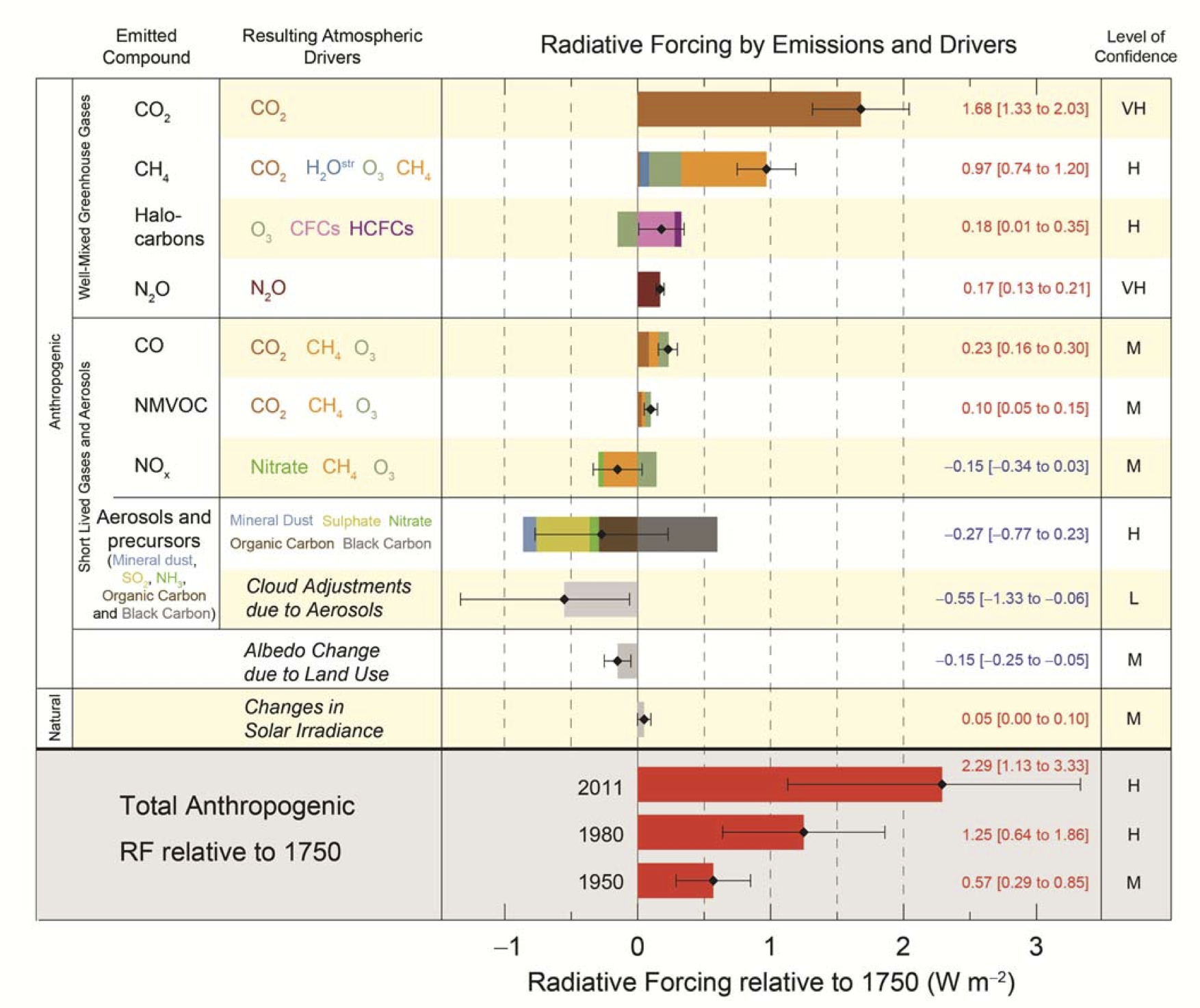
The above image shows IPCC projections for CO₂ concentration and temperature change for the SSP5-8.5 scenario. The IPCC translates concentrations of greenhouse gases into radiative forcing (see image below), which can in turn be converted into temperature change (see image above) by using a climate sensitivity multiplier.

In the SSP5-8.5 scenario, radiative forcing is by definition projected to increase to 8.5 W/m² by 2100. When using an (older) climate sensitivity multiplier of 0.75, this could result in a temperature rise of more than 6°C by 2100. Recent research such as by James Hansen et al. suggests that a higher climate sensitivity multiplier should be used, which could result in a temperature rise of more than 10°C by 2100 in the SSP5-8.5 scenario.
The IPCC has a history of trying to downplay the strength of global warming and refuses to accept that its projections have been too low. Lo and behold, some scientist have now come forward to accommodate the IPCC by suggesting to drop SSP5-8.5 altogether, arguing it had become "implausible, based on trends in the costs of renewables, the emergence of climate policy and recent emission trends".
Let's take a look into those arguments. While the cost of renewables and sales of coal have fallen, the emergence of climate policy depends on political opinion. The temperature rise is accelerating and feedbacks are threatening to kick in with greater ferocity. The rise in the Earth Energy Imbalance and in ocean heat is outpacing SPSS5-8.5, as discussed in an earlier post. Furthermore, the aerosol masking effect is decreasing. Additionally, IPCC models subtract assumed carbon dioxide removal (CDR), despite doubts regarding the way the IPCC seeks CDR to take place, as discussed in this post and in this video posted on facebook.
Therefore, it is vital to include SSP5-8.5 as a reference, in order to inform and warn about a potentially huge temperature rise, the more so since mainstream media fail to do so and policymakers typically look only a few years ahead. Indeed, not including warnings could be a recipe for bad climate policy, halting or even reversing the necessary climate action.
Feedbacks
 |
| [ click on image to enlarge ] |
There are numerous feedbacks that can dramatically accelerate the temperature rise, such as albedo changes and changes to wind tracks and ocean currents causing oceans to take up less heat, resulting in more heat in the atmosphere.
The danger is that a strong storm will cause a huge amount of warm, salty water to travel underneath the surface of the Atlantic Ocean into the shallow parts of the Arctic Ocean, pushing up temperatures and salinity levels at the seafloor and destabilizing methane hydrates, in turn resulting in eruptions of methane from these hydrates and from free gas underneath the hydrates, as discussed at this post and at this page.
The danger increases as greenhouse gases keep rising, so let's have a look at recent concentrations.
Carbon dioxide (CO₂)
The image below, from an earlier post, shows the CO₂ concentration over 31 days at Mauna Loa, Hawaii. The hand points at a daily CO₂ concentration of 433.95 parts per million (ppm) recorded on May 1, 2026.

The image below, dated June 1, 2026, shows carbon dioxide concentration over the past few years at Mauna Loa, Hawaii. Note the high surface flask measurements recorded recently.

The image below shows daily carbon dioxide at Utqiaġvik, formerly know as Barrow, Alaska, June 1, 2026.

Nitrous oxide (N₂O)
The image below shows nitrous oxide concentration at Mauna Loa, Hawaii, June 1, 2026.

The image below shows monthly nitrous oxide at Utqiaġvik, formerly know as Barrow, Alaska, June 1, 2026.

Nitrous oxide has a lifetime of 109 years and a Global Warming Potential (GWP) of 273 for a horizon of 20 years and also a GWP of 273 over 100 years, according to IPCC AR6. Nitrous oxide is both a potent greenhouse gas and a compound that depletes ozone in the ozone layer.
The image below shows the globally averaged marine surface mean nitrous oxide concentration through 2025 with a trend added to show the potential for a huge rise by 2047.

Methane (CH₄)
The image below shows monthly methane at Mauna Loa, Hawaii, June 1, 2026.

 |
| [ from earlier post, discussed on facebook ] |
Greenhouse gas concentrations are rising and carbon dioxide and nitrous oxide are rising fast, while methane is rising even faster (see image on the right) and more methane threatens to erupt from the seafloor, as discussed in earlier posts such as this one and this one.
There are many feedbacks that further contribute to the temperature rise (such as albedo loss and more heat moving into or remaining in the atmosphere instead of being absorbed by oceans, ice and land, as discussed below). Altogether, this could result in a temperature rise of more than 20°C within one year, as discussed in an earlier post.
The image below show that a methane peak of 2652 parts per billion was recorded at 399.1 mb by the NOAA20 satellite on June 21, 2026 AM. Methane peaks this high at such altitudes can be caused by an eruption of seafloor methane that rises up in the form of plumes.

Sulfur hexafluoride (SF₆)
The image below shows a worrying recent rise in concentrations of sulfur hexafluoride (SF₆), which has a global warming potential (GWP) over 100 years of 24,300 and, because it has a lifetime of 1000 years, its GWP over 500 years is even higher, i.e. 29,000 (IPCC AR6).

Regarding SF₆, one does not have to bother to check historical levels, since the vast majority of SF₆ in the atmosphere is produced by people, it's a synthetic, industrial gas that leaked from its use mainly as an insulator in high-voltage and medium-voltage power systems and lines that can carry power over long distances. Clearly, too little is done politically to reduce SF₆ emissions, even though there are safe, viable alternatives available to using SF₆ in the power industry. Furthermore, rooftop solar systems can - where needed - be part of microgrids, which can reduce the need for transmission lines, poles and towers, so microgrids can also reduce fire hazards. Fire can also destroy warehouses where SF₆ is stored in tanks.
For high concentrations of surfur hexafluoride recorded at other locations, also see this post and comments at facebook.
The image below shows global annual mean SF₆ through 2025, with a trend added to show the potential for a huge rise by 2037.


The image below shows a Copernicus forecast of carbon monoxide for June 5, 2026.


Not only is the extra energy increasing, as depicted by the above images, but the proportions of where the extra energy is going is additionally changing, resulting in an increasingly higher temperature rise of the lower atmosphere, as described below.
- Oceans
The ocean's capacity to act as an energy buffer is increasingly compromised by stratification, changes to ocean currents, changes in salinity, ocean oxygen depletion, acidification and more, as discussed in earlier posts such as this one. This is a big issue, since oceans take up 91% of the extra heat caused by greenhouse gases, so if there is even a 1% reduction in the heat taken up by oceans, the heat remaining in the atmosphere may double.
- Ice
Furthermore, the capacity for ice to act as a buffer by consuming energy in the process of melting is increasingly compromised by sea ice decline, by retreat of glaciers, and by darkening of ice due to dust, algae, black carbon and more. Arctic sea ice is facing a Blue Ocean Event with sea ice decline threatening to both dramatically lower albedo and reduce the ability for ocean heat to be consumed in the process of melting. Mountain glaciers are also in decline and permafrost is approaching the point where thawing of permafrost will speed up rapidly, as discussed in earlier posts such as this one.
- Land
The capacity for land to take up heat also faces a tipping point: The Land Evaporation Tipping Point can get crossed locally when water is no longer available locally for further evapotranspiration, i.e. from all processes by which water moves from the land surface to the atmosphere via evaporation and transpiration, including transpiration from vegetation, evaporation from the soil surface, from the capillary fringe of the groundwater table, and from water bodies on land. Once this tipping point gets crossed, the land and atmosphere will heat up strongly, due to the extra heat, i.e. heat that was previously consumed by evaporation and thawing, as described at this page.
- Atmosphere
As said, while the extra energy is increasing, as depicted by the above images, the capacity of oceans, land and ice to take up more energy is decreasing. Consequently, an increasingly large amount of extra heat threatens to accumulate in the lower atmosphere, especially in the Northern Hemisphere over land and in the Arctic, where temperatures are rising faster than anywhere in the world.
- Wetlands and freshwaters
The image below is adapted from a recent study led by Zhen Zhang and shows projections in which the tropics (30° S–30° N) contribute approximately 68% of the net increase in estimated wetlands methane emissions, while temperate regions (30° N–60° N) and the Arctic (>60° N) are expected to contribute 21% and 8%.

Approximately half of all methane (CH₄) emissions come from freshwaters, where they are regulated by the microbial ‘CH₄ filter’ whose efficiency describes the fraction of CH₄ produced that is subsequently oxidized back to CO₂ (methanotrophy) before emission. CH₄ production becomes more efficient with warming, linked to increased abundance of methanogens and underpinned by community shifts. In contrast, while CH₄ oxidation activity increases, its process-level efficiency does not, and methanotrophs shift towards less efficient taxa. Consequently, the system-level CH₄ filter efficiency remains fixed, and CH₄ emissions increase. If this fixed CH₄ filter efficiency under warming is common to freshwaters worldwide (wetlands, lakes and rivers), then an upward trajectory for CH₄ emissions through future climate change appears inevitable. From a recent study led by Sarah Harpenslager.
Compounding dangers in Arctic

Peatlands store approximately 30% of the global total soil carbon, with 80% of this carbon contained in Arctic peatlands. An emerging concern caused by accelerated climate change and permafrost thaw is the rapid increase in Arctic peatland fires, which have already expanded to the Siberian Arctic Ocean coast, Greenland, and Alaskan tundra peatlands. These fires occur along with record-breaking boreal forest fires raging in Canada. Peat fires may smolder for weeks and months, releasing massive amounts of, potentially ancient, carbon, which may transform them from a major carbon sink into a net carbon source into the atmosphere.
In addition to globally significant greenhouse gas emissions, peatland fires release abundant particulate matter. Smoldering peat fires may emit six times more aerosol mass per unit carbon combusted compared to flaming (grassland and forest) fires. Wildfires are a major source of Black Carbon (BC), which is the strongest light-absorbing particulate with a large positive global radiative effect. Simultaneously, wildfires release abundant Organic Carbon (OC), which can have a cooling effect either directly by scattering solar radiation or indirectly by modulating cloud properties. However, increasing evidence of substantial light-absorbing OC, i.e., Brown Carbon (BrC), being emitted in wildfires, suggests that the atmospheric net effect of biomass burning plumes is warming, as specifically shown for boreal and Indonesian peat combustion, while the properties and atmospheric lifetime of BrC vary depending on, for instance, combustion characteristics, biomass type, and moisture content. Moreover, BC and BrC decrease surface albedo when deposited on snow and ice, further accelerating Arctic climate change. Consequently, increasing high-latitude peatland fires are of great concern in the vicinity of snow- and ice-covered surfaces.
Ominously, a peak methane level of 2628 parts per million (ppb) was recorded at 695.1 mb by the NOAA 20 satellite on May 18, 2026 PM, as illustrated by the above image, while the image below shows a peak level of 2579 ppb recorded by the NOAA 21 satellite on May 13, 2026 PM, at 840 mb, which is even closer to sea level, indicating that large releases of methane may have taken place from the seafloor of the ocean.


This is an update of an earlier post that also discusses the Earth Energy Imbalance and the threat of a rapid rise in methane in more detail.
Carbon monoxide (CO)
The image below, dated June 5, 2026, shows carbon monoxide (CO) concentration over the past few years at Mauna Loa, Hawaii, with some high recent readings showing up.


 |
| [ image from earlier post ] |
CO acts as the largest single sink for hydroxyl (OH). Elevated CO concentrations can therefore cause OH depletion that results in increases in the atmospheric lifespan of methane. More methane in turn also results in more ozone and stratospheric water vapor.
The IPCC AR5 image on the right depicts the global warming potential (GWP) and carbon dioxide equivalent (CO₂e) of methane (brown bars) and carbon monoxide (grey bars).
The IPCC AR5 image on the right depicts the global warming potential (GWP) and carbon dioxide equivalent (CO₂e) of methane (brown bars) and carbon monoxide (grey bars).
The image below shows the effective radiative forcing of methane, ozone and stratospheric water vapor.

Earth energy imbalance
As temperatures rise, the outgoing longwave radiation has not risen as fast as the absorbed incoming solar radiation, due to weakening of the Planck feedback as geographical patterns of warming are shifting and due to high (and rising) concentrations of greenhouse gases and loss of albedo, resulting in an increasingly larger amount of extra energy stored on Earth. The image below, from an earlier post, depicts Earth energy imbalance (in orange), i.e. the extra energy that is left after subtracting outgoing longwave radiation (in red) from incoming solar radiation (in black).
As temperatures rise, the outgoing longwave radiation has not risen as fast as the absorbed incoming solar radiation, due to weakening of the Planck feedback as geographical patterns of warming are shifting and due to high (and rising) concentrations of greenhouse gases and loss of albedo, resulting in an increasingly larger amount of extra energy stored on Earth. The image below, from an earlier post, depicts Earth energy imbalance (in orange), i.e. the extra energy that is left after subtracting outgoing longwave radiation (in red) from incoming solar radiation (in black).

Where does the extra energy go? According to the IPCC AR6 WG1, 91% of the extra energy is taken up by oceans, 5% by land, 3% by ice melting and 1% remains in the atmosphere. Oceans, land and melting ice thus act as a buffer that did take up the vast majority (99%) of the extra energy, based on IPCC data. The image below, by Leon Simons, shows how, over time, absorbed solar radiation (black line) has increased more rapidly than outgoing longwave radiation (red line). The orange-colored area in between the lines depicts Earth's Energy Imbalance, or the extra energy that remains on Earth.
 |
| [ image by Leon Simons, discussed on facebook ] |
- Oceans
The ocean's capacity to act as an energy buffer is increasingly compromised by stratification, changes to ocean currents, changes in salinity, ocean oxygen depletion, acidification and more, as discussed in earlier posts such as this one. This is a big issue, since oceans take up 91% of the extra heat caused by greenhouse gases, so if there is even a 1% reduction in the heat taken up by oceans, the heat remaining in the atmosphere may double.
- Ice
Furthermore, the capacity for ice to act as a buffer by consuming energy in the process of melting is increasingly compromised by sea ice decline, by retreat of glaciers, and by darkening of ice due to dust, algae, black carbon and more. Arctic sea ice is facing a Blue Ocean Event with sea ice decline threatening to both dramatically lower albedo and reduce the ability for ocean heat to be consumed in the process of melting. Mountain glaciers are also in decline and permafrost is approaching the point where thawing of permafrost will speed up rapidly, as discussed in earlier posts such as this one.
- Land
The capacity for land to take up heat also faces a tipping point: The Land Evaporation Tipping Point can get crossed locally when water is no longer available locally for further evapotranspiration, i.e. from all processes by which water moves from the land surface to the atmosphere via evaporation and transpiration, including transpiration from vegetation, evaporation from the soil surface, from the capillary fringe of the groundwater table, and from water bodies on land. Once this tipping point gets crossed, the land and atmosphere will heat up strongly, due to the extra heat, i.e. heat that was previously consumed by evaporation and thawing, as described at this page.
- Atmosphere
As said, while the extra energy is increasing, as depicted by the above images, the capacity of oceans, land and ice to take up more energy is decreasing. Consequently, an increasingly large amount of extra heat threatens to accumulate in the lower atmosphere, especially in the Northern Hemisphere over land and in the Arctic, where temperatures are rising faster than anywhere in the world.
- Wetlands and freshwaters
The image below is adapted from a recent study led by Zhen Zhang and shows projections in which the tropics (30° S–30° N) contribute approximately 68% of the net increase in estimated wetlands methane emissions, while temperate regions (30° N–60° N) and the Arctic (>60° N) are expected to contribute 21% and 8%.


Peatlands store approximately 30% of the global total soil carbon, with 80% of this carbon contained in Arctic peatlands. An emerging concern caused by accelerated climate change and permafrost thaw is the rapid increase in Arctic peatland fires, which have already expanded to the Siberian Arctic Ocean coast, Greenland, and Alaskan tundra peatlands. These fires occur along with record-breaking boreal forest fires raging in Canada. Peat fires may smolder for weeks and months, releasing massive amounts of, potentially ancient, carbon, which may transform them from a major carbon sink into a net carbon source into the atmosphere.
In addition to globally significant greenhouse gas emissions, peatland fires release abundant particulate matter. Smoldering peat fires may emit six times more aerosol mass per unit carbon combusted compared to flaming (grassland and forest) fires. Wildfires are a major source of Black Carbon (BC), which is the strongest light-absorbing particulate with a large positive global radiative effect. Simultaneously, wildfires release abundant Organic Carbon (OC), which can have a cooling effect either directly by scattering solar radiation or indirectly by modulating cloud properties. However, increasing evidence of substantial light-absorbing OC, i.e., Brown Carbon (BrC), being emitted in wildfires, suggests that the atmospheric net effect of biomass burning plumes is warming, as specifically shown for boreal and Indonesian peat combustion, while the properties and atmospheric lifetime of BrC vary depending on, for instance, combustion characteristics, biomass type, and moisture content. Moreover, BC and BrC decrease surface albedo when deposited on snow and ice, further accelerating Arctic climate change. Consequently, increasing high-latitude peatland fires are of great concern in the vicinity of snow- and ice-covered surfaces.
The above text and comparison images are adapted from a 2026 analysis led by Meri Ruppel.
 |
| [ image from earlier post, click to enlarge ] |
 |
| [ image from earlier post, click to enlarge ] |
For more on the danger of rising methane concentrations, see the Clouds Tipping Point post.
Could the Northern Hemisphere land-only temperature rise exceed 3°C soon?
The upcoming El Niño could trigger a rapid and steep rise in temperature on land in the Northern Hemisphere, as illustrated by the combination image below that uses land-only data in the top panel and Northern Hemisphere data in the bottom panel.
The upcoming El Niño could trigger a rapid and steep rise in temperature on land in the Northern Hemisphere, as illustrated by the combination image below that uses land-only data in the top panel and Northern Hemisphere data in the bottom panel.
 |
| [ image from earlier post, discussed on facebook here ] |
Conclusion
The situation is dire and unacceptably dangerous, and the precautionary principle necessitates rapid, comprehensive and effective action to reduce the damage and to improve the outlook, where needed in combination with a Climate Emergency Declaration, as described in posts such as in this 2022 post and this 2025 post, and as discussed in the Climate Plan group.

Links
• NOAA - Global Monitoring Laboratory - data viewer
https://gml.noaa.gov/dv/iadv
• NOAA - Global Monitoring Laboratory - Carbon Cycle Greenhouse Gases - Mauna Loa, Hawaii
https://gml.noaa.gov/ccgg/trends/mlo.html
• NOAA - Office of Satellite and Products Operations - NOAA-20 and NOAA-21 satellites
https://www.ospo.noaa.gov/products/atmosphere/soundings/heap/nucaps/new/nucaps_products.html
• IPCC AR6, Workgroup 1, Chapter 4, Future Global Climate: Scenario-based Projections and Near-term Information
https://www.ipcc.ch/report/ar6/wg1/downloads/report/IPCC_AR6_WGI_Chapter04.pdf
• IPCC AR6, Workgroup 1, Chapter 7, Supplementary material - SF6 GWP and lifetime
https://www.ipcc.ch/report/ar6/wg1/downloads/report/IPCC_AR6_WGI_Chapter07_SM.pdf
• Copernicus - carbon monoxide forecasts
https://atmosphere.copernicus.eu/charts/packages/cams/products/carbon-monoxide-forecasts
• Indicators of Global Climate Change 2025: annual update of key indicators of the state of the climate system and human influence - by Piers Forster et al. (2026)
https://essd.copernicus.org/preprints/essd-2026-287/essd-2026-287.pdf
• A fixed methane filter maximizes freshwater emissions under warming - by Sarah Harpenslager et al. https://www.nature.com/articles/s41558-026-02649-2
as discussed on facebook at:
https://www.facebook.com/groups/arcticnews/permalink/10164343110889679
• Transforming Society
https://arctic-news.blogspot.com/2022/10/transforming-society.html
• Climate Plan
https://arctic-news.blogspot.com/p/climateplan.html
• Climate Emergency Declaration
https://arctic-news.blogspot.com/p/climate-emergency-declaration.html
https://gml.noaa.gov/dv/iadv
https://gml.noaa.gov/ccgg/trends/mlo.html
https://www.ospo.noaa.gov/products/atmosphere/soundings/heap/nucaps/new/nucaps_products.html
https://www.ipcc.ch/report/ar6/wg1/downloads/report/IPCC_AR6_WGI_Chapter04.pdf
https://www.ipcc.ch/report/ar6/wg1/downloads/report/IPCC_AR6_WGI_Chapter07_SM.pdf
https://atmosphere.copernicus.eu/charts/packages/cams/products/carbon-monoxide-forecasts
https://essd.copernicus.org/preprints/essd-2026-287/essd-2026-287.pdf
as discussed on facebook at:
https://www.facebook.com/groups/arcticnews/permalink/10164343110889679
https://arctic-news.blogspot.com/2022/10/transforming-society.html
https://arctic-news.blogspot.com/p/climateplan.html
https://arctic-news.blogspot.com/p/climate-emergency-declaration.html


