Tuesday, November 5, 2024

Sea ice alert

Sea ice

[ click on images to enlarge ]
The above image shows Arctic sea ice extent from November 5 to December 24, a period when Arctic sea ice is growing in extent. The red line shows 2024 sea ice extent through November 23, 2024. Dots mark Arctic sea ice extent on November 23 for the respective year. On November 23, Arctic sea ice extent was lower only in 2016, which is worrying, since El Niño conditions were dominant in 2016, whereas La Niña conditions are now dominant. 

The current La Niña is predicted to be weak and short-lived, as illustrated by the image below, from NOAA


The image below shows NOAA monthly temperature anomalies versus El Niño through October 2024. 


The image below shows Antarctic sea ice extent during the months September and October, highlighting extent in 2023 and 2024, as compared to extent averages in previous decades.

As illustrated by the above image, Antarctic sea ice extent in September and October 2023 & 2024 was much lower than in previous decades, a huge difference that occurred during a period when little or no sunlight was reaching Antarctic sea ice. On November 9, 2024, Antarctic sea ice extent was 14.99 million km², a record low for the time of year.

Global sea ice typically reaches its annual maximum extent around this time of year, as Arctic sea ice expands in extent. On November 9, 2024, global sea ice extent was 23.34 million km², a record low for the time of year and well below the 24.15 million km² on November 9, 2023. 


Higher ocean heat in combination with higher air temperatures over the Arctic Ocean are two drivers behind the current slow growth in Arctic sea ice extent, which is in turn keeping global sea ice extent low.

[ from earlier post ]
Record low Arctic sea ice extent of 3.387 million km² was reached on September 17, 2012 (image below left). 

The fact that this has remained the record low for more than a dozen years may be caused by slowing down of the Atlantic meridional overturning circulation (AMOC) resulting in less ocean heat reaching the highest latitudes North, while more ocean heat instead is accumulating in the North Atlantic. 

At the same time, rising ocean heat has caused a steady decrease in the volume of Arctic sea ice, as illustrated by the image on the right.  

The danger is that as more heat accumulates in the North Atlantic, some of it can get abruptly pushed into the Arctic Ocean along the path of the Gulf Stream due to ever stronger hurricanes and formation of a freshwater lid at the surface of the North Atlantic, resulting in more ocean heat reaching the seafloor of the Arctic Ocean and destabilizing sediments that contain hydrates holding huge amounts of methane, in turn resulting in huge amounts of methane abruptly entering the atmosphere. 

[ click on images to enlarge ]

Antarctic sea ice reached a record minimum extent of 1.788 million km² on February 21, 2023 (above image right). The increasingly low Antarctic sea ice extent of the past few years may have been caused by slowing down of AMOC causing less vertical mixing in the Southern Ocean, resulting in more heat  accumulating at the surface that melted more Antarctic sea ice, with numerous feedbacks reinforcing the sea ice decline.

Since the minimum extent of Antarctic sea ice is much lower than the minimum sea ice extent in the Arctic, it may well be that a Blue Ocean Event (BOE) will occur in the Southern Hemisphere, before occurring in the Northern Hemisphere. 

A double Blue Ocean Event could occur in 2025. Both Antarctic sea ice and Arctic sea ice could virtually disappear in 2025. A BOE occurs when sea ice extent falls to 1 million km² or less, which could occur early 2025 for Antarctic sea ice and in Summer 2025 in the Northern Hemisphere for Arctic sea ice.

The compilation of four images by the University of Bremen below illustrates the decline in Antarctic sea ice thickness from August 27, 2024, to November 28, 2024.


An Antarctic Blue Ocean Event in early 2025 would have terrifying consequences; it would rapidly and dramatically drive up global temperatures and threaten to unleash a double Blue Ocean Event in 2025.  

The image and the right and below illustrate the ocean heat that is accumulating at the surface of the Atlantic Ocean.

On November 30, 2024, the sea surface temperature of the US Atlantic was as high as 31.1°C.

On November 28, 2024, the sea surface temperature was 27.1°C in the Gulf of Mexico, 2.07°C higher than 1982-2010.  

[ click on images to enlarge ]

Historic rise: more than 1.5°C above 1903-1924 for 16 consecutive months 


The above image, created with NASA data through October 2024 while using a 1903-1924 custom base, illustrates that the monthly temperature anomaly has been more than 1.5°C above this base for 16 consecutive months (from July 2023 through October 2024). The red line shows a trend (2-year Lowess Smoothing) associated with recent data and the trend indicates that the anomaly is rising. 

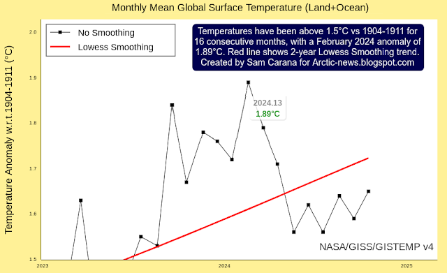
How appropriate is the use of a 1903-1924 base? Using a different base can make a lot of difference. As illustrated by the image below, the temperature anomaly for February 2024 can be as high as 1.89°C when using a 1904-1911 base. 


A recent study argues that existing estimates of ocean temperatures for the period 1900–1930 are too cold. When adjusting ocean data upward, the anomaly compared to this period would come down, so in order not to downplay the temperature rise, it's important to put this into perspective.

As the image below shows, differences between ocean and land data for the period 1880-1898 are even larger, which is important since the period 1880-1898 is part of the period that the IPCC has selected as pre-industrial base. 


While adjusting ocean data for 1921-1943 makes sense, it is even more important to use the most appropriate base as pre-industrial and to adjust the temperature rise from pre-industrial accordingly. When using a genuinely pre-industrial base, anomalies such as the above-mentioned 1.89°C for February 2024 will exceed 2°C, as discussed at the pre-industrial page

[ click on images to enlarge ]
The map on the right with October 2024 temperature anomalies from 1951-1980 based on NCEP data shows high polar anomalies.   

Similarly, the map below with October 2024 temperature anomalies from 1951-1980 based on ERA5 data shows high polar anomalies.  

The 1951-1980 base for the maps is NASA's default base, but neither 1951-1980 nor the above 1903-1924 is pre-industrial. As said, anomalies from a pre-industrial base are higher.


The rise to come

As illustrated by the image below, adapted from Copernicus, the temperature in 2024 has been higher than it was in 2023 for most of the year. On November 23, 2024, the temperature was 13.86°C, the highest on record for the time of year. 


The image below shows temperature anomalies versus 1991-2020 from early 2023 through November 23, 2024. Trends added to the ERA5 data show that the anomaly has been rising for almost 18 consecutive months, i.e. since the start of El Niño (June 2023, pink shading), during ENSO-neutral conditions (from May 2024, blue shading) and into La Niña (from October 2024, also blue shading).


The black linear trend shows a huge rise. The red trend is closer in line with variability such as resulting from ENSO and sunspots. The red trend indicates very high anomalies and a steep further rise into 2025, in line with the next El Niño becoming dominant in the second half of 2025, coinciding with very high sunspots.

Self-amplifying feedbacks, crossing of tipping points and further developments (such as loss of the aerosol masking effect) can all contribute to further accelerate the temperature rise through 2026, resulting in a rise from pre-industrial of more than 10°C, while in the process causing the clouds tipping point to get crossed that can push up the temperature rise by a further 8°C, as discussed in earlier posts such as this one.

Jet Stream distortion

As a result of the narrowing temperature difference between the Arctic and the Tropics, the Jet Stream gets distorted. The image below shows a distorted Jet Stream (250 hPa) over the North Atlantic on November 11, 2024. 


Precipitation

The image below shows an atmospheric river stretched out over the North Atlantic from the Tropics to the Arctic with high rainfall over the North Atlantic and snowfall over Greenland on November 11, 2024.  


Water vapor

The image below shows a forecast for November 12, 2024, with precipitable water anomalies at the high end of the scale over the Arctic Ocean. 

Feedbacks

The image below illustrates how multiple feedbacks can interact and jointly contribute to further acceleration of the temperature rise.

[ from earlier post ]

There are many feedbacks and other mechanisms active and they are interacting on top of driving up temperatures individually. 

Albedo change is a feedback that can have a huge impact. The currently very low global sea ice extent is a self-reinforcing feedback, as it results in less sunlight getting reflected back into space and more heat getting absorbed by oceans.

Extra water vapor is another self-reinfocing feedback, since water vapor is a potent greenhouse gas. 

These are just some of the feedbacks that can contribute to further acceleration of the temperature rise, as discussed in an earlier post.

Carbon dioxide keeps rising

The above image shows carbon dioxide on November 12, 2024 - forecast for 03 UTC by Copernicus. The graph at the bottom of the image shows monthly carbon dioxide exceeding 425 ppb in October 2024 at Mauna Lao, Hawaii, based on NOAA data with trend added.


The images on the right, adapted from Climate Reanalyzer, shows the total precipitation standardized anomaly over the past few years. The top image shows the anomaly in Brazil.

The image underneath on the right shows the anomaly in Africa. In many places, what were previously carbon sinks have turned into sources of carbon emissions.

[ click on images to enlarge ]
Methane

Ominously, high methane peaks have been recorded recently. The image below shows - on the left - that methane reached a peak of 2616 parts per billion (ppb) at 481.5-489 mb on November 28, 2024 pm, with high methane levels recorded over the Arctic and also over Antarctica. The image below shows - on the right - that, on November 28, 2024 pm, high methane levels were present over the oceans at 988.6-1002.4 mb. 


Where does the methane come from?

The image on the right shows methane at pressure levels from 988.6 to 1002.4 mb, which corresponds to near sea level, so no methane does show up on over land with higher elevation, e.g. Greenland, Antarctica, even Australia (lowest continent). 

Methane is light and will rise up in the atmosphere, so more methane will typically accumulate at higher altitudes than at near sea level. Much of the methane that is visible at the higher altitude image (left) is also present at the low altitude image (right) and at relatively high concentrations, peaking at 2415 parts per billion (ppb). 

Furthermore, on the image on the left with the 2616 ppb peak, relatively little extra magenta-colored methane shows up over continental areas where typically high concentrations are present, compared to the image on the right. 

These points indicate that much of the high concentrations of methane could have originated from oceans and from hydrates in sediments that are getting destabilized by high temperature swings. 

[ click on images to enlarge ]

As mentioned above, ocean heat threatens to destabilize sediments that contain hydrates holding huge amounts of methane, resulting in huge amounts of methane abruptly entering the atmosphere.

[ The Buffer has gone, feedback #14 on the Feedbacks page ]
Dangers associated with high temperatures are discussed in this earlier post. A 2018 study (by Strona & Bradshaw) indicates that most life on Earth will disappear with a 5°C rise. Humans, who depend for their survival on many other species, will likely go extinct with a 3°C rise, as illustrated by the image below, from an earlier post.


Climate Emergency Declaration

The situation is dire and the precautionary principle calls for rapid, comprehensive and effective action to reduce the damage and to improve the situation, as described in this 2022 post, where needed in combination with a Climate Emergency Declaration, as discussed at this group.


Links

• National Institute of Polar Research Japan
https://ads.nipr.ac.jp

• NOAA - Climate Prediction Center - 14 November 2024
https://www.cpc.ncep.noaa.gov/products/analysis_monitoring/enso_advisory/ensodisc.html

• University of Bremen - sea ice
also discussed on facebook at: 
https://www.facebook.com/groups/arcticnews/posts/10162009995269679

• NOAA - sea surface temperatures - Contoured Regional Images of Blended 5 km SST Analysis 

• Early-twentieth-century cold bias in ocean surface temperature observations - by Sebastian Sippel et al. 
discussed on facebook at: 
https://www.facebook.com/groups/arcticnews/posts/10161956156144679

• pre-industrial
https://arctic-news.blogspot.com/p/pre-industrial.html

• Climate Reanalyzer
https://climatereanalyzer.org

• Copernicus
https://climate.copernicus.eu

• NOAA - Global Monitoring Laboratory - Carbon Cycle Gases, trends in CO2
https://gml.noaa.gov/ccgg/trends
also discussed on facebook at: 
https://www.facebook.com/groups/arcticnews/posts/10161904718934679
 
https://www.facebook.com/SamCarana/posts/10169996053330161

• Sunspots
https://arctic-news.blogspot.com/p/sunspots.html

• Feedbacks in the Arctic
https://arctic-news.blogspot.com/p/feedbacks.html

• Jet Stream
https://arctic-news.blogspot.com/p/jet-stream.html

• Pre-industrial
https://arctic-news.blogspot.com/p/pre-industrial.html

• The Clouds Feedback and the Clouds Tipping Point
https://arctic-news.blogspot.com/p/clouds-feedback.html

• NOAA - HEAP IASI - methane
https://www.ospo.noaa.gov/products/atmosphere/soundings/heap/iasi/iasiproducts.html

• Transforming Society
https://arctic-news.blogspot.com/2022/10/transforming-society.html

• Climate Plan
https://arctic-news.blogspot.com/p/climateplan.html

• Climate Emergency Declaration
https://arctic-news.blogspot.com/p/climate-emergency-declaration.html


Saturday, October 26, 2024

Models downplay wrath of what they sow

Models that analyze what is driving up the temperature all too often omit specific sources, or when included, models all too often downplay their contribution. Accordingly, policies that are promoted based on such models are all too often ineffective or even counter-productive. 

Methane is all too often referred to as 'natural gas' originating from wetlands, swamps, cows and pigs, as if calling methane 'natural' implied that human activities were not responsible for such emissions. Moreover, people with vested interests all too often suggest that such 'natural emissions' should be captured and used for heating, cooking or industrial purposes, to offset 'human emissions'. Similarly, forest fires are all too often referred to as 'wildfires', as if human activities were not responsible for them. 

The compilation of images below shows forest fires as the largest source of carbon dioxide emissions on October 26, 2024. An image of carbon monoxide is also added (bottom right), as carbon monoxide is an indicator of forest fires. Carbon monoxide is also important since it is a precursor of tropospheric ozone and carbon monoxide depletes tropospheric hydroxyl radicals, thus extending methane's lifetime. 


The methane image (top right) shows a high presence of methane in northern Europe. The cause for this is the high temperatures anomaly in northern Europe on October 26, 2024, resulting in strong decomposition of vegetation, which comes with high emissions of carbon dioxide, carbon monoxide and methane. 


The high temperatures anomaly in northern Europe is illustrated by the above image. The image also illustrates polar amplification of the temperature rise, one of the mechanisms that drives up the temperature rise. Numerous mechanisms driving up the temperature rise are discussed in an earlier post that warns about a Double Blue Ocean Event. Thawing permafrost can cause huge emissions of carbon dioxide (CO₂), methane and nitrous oxide. 

[ from earlier post ]
Rising emissions could originate from many sources, the more so as more sinks turn into sources.
[ from earlier post ]
Many models go back only to 1750, many even use an earlier base, as if concentrations of greenhouse gases only started to rise then. 

The image on the right shows IPCC and WMO values for the rise of methane (CH₄), carbon dioxide (CO₂) and nitrous oxide (N₂O) from 1750. The image shows that: 
- Methane rose to 265% its 1750 value. - Carbon dioxide rose to 151% its 1750 value.
- Nitrous oxide rose to 125% its 1750 value.

Note that values for methane as low as 550 ppb and carbon dioxide as low as 260 ppm have been found in ice cores corresponding with periods thousands of years ago, as illustrated by the image below, from the pre-industrial page, based on Ruddiman et al. (2015)


According to the Met Office, climate sensitivity is typically defined as the global temperature rise following a doubling of CO₂ concentration in the atmosphere compared to pre-industrial levels. Pre-industrial CO₂ was about 260 parts per million (ppm), so a doubling would be at roughly 520 ppm.

recent study found that doubling the atmospheric CO₂ levels could cause an increase in Earth’s average temperature of 7 to 14°C (13 to 25.2°F). In the video below, Guy McPherson discusses the study.


How fast could a rise to 520 ppm CO₂ unfold? Models typically put 520 ppm CO₂ far away in the future. The image below shows an analysis based on August 2009 through July 2024 data that has a trend added pointing at 520 ppm CO₂ getting crossed in 2029 and 1200 ppm CO₂ getting crossed in early 2035. In other words, the clouds tipping point could get crossed in early 2035 due to rising CO₂ alone, and because this tipping point is measured in CO₂e, this could occur well before 2035 when including the impact of feedbacks and further mechanisms.

[ from earlier post ]

Another way the danger of rising temperatures is all too often downplayed is to suggest that many feedbacks work only over very long timescales. This narrative may be convenient for politicians who rarely bother about what happens beyond the next election. However, as discussed in a recent post, there are many mechanisms that can push up the temperature rapidly, adding up to a potential rise of more than 18°C within years.

Climate Emergency Declaration

Instead of omitting them, all mechanisms driving up the temperature should be fully included in an action plan that seeks to improve the situation. Multiple policy instruments and combinations of policy instruments should be considered for implementation, preferably through local feebates

The situation is dire and the precautionary principle calls for rapid, comprehensive and effective action to reduce the damage and to improve the situation, as described in this 2022 post, where needed in combination with a Climate Emergency Declaration, as discussed at this group.


Links

• Copernicus - Climate Pulse
https://atmosphere.climate.copernicus.eu

• Climate Reanalyzer 
https://climatereanalyzer.org

• World Meteorological Organization (WMO) - Greenhouse Gas Bulletin - No. 20 – 28 October 2024

• Double Blue Ocean Event 2025? 
https://arctic-news.blogspot.com/2024/10/double-blue-ocean-event-2025.html

• Continuous sterane and phytane δ13C record reveals a substantial pCO2 decline since the mid-Miocene - by Caitlyn R. Witkowski et al. (2024) 


Friday, October 4, 2024

Double Blue Ocean Event 2025?

A double Blue Ocean Event could occur in 2025. Both Antarctic sea ice and Arctic sea ice could virtually disappear in 2025. A Blue Ocean Event (BOE) occurs when sea ice extent falls to 1 million km² or less, which could occur early 2025 for Antarctic sea ice and in Summer 2025 in the Northern Hemisphere for Arctic sea ice.

Arctic sea ice volume

In September 2024, Arctic sea ice reached a new record low volume, as illustrated by the image below, adapted from the Danish Meteorological Institute, with markers for September (red) and April (blue) corresponding with the year's minimum- and maximum volume.


Trends could be added pointing at Arctic sea ice approaching zero volume soon; even more worrying, tipping points could be crossed and speed up the temperature rise beyond a smooth curve. Feedbacks are typically seen as increasing the temperature gradually and smoothly, either in a linear or non-linear way. Feedbacks are mechanisms, but there are also mechanisms that act more abruptly.

Indeed, some mechanisms can have a more abrupt impact. Sea ice could shrink strongly and rapidly as a (tipping) point is reached where the latent heat buffer disappears abruptly and as further incoming ocean heat suddenly can no longer be consumed by melting of what once was thick sea ice that extended meters below the surface. Arctic sea ice typically reached its annual low about half September, but an abrupt decline of Arctic sea ice may well occur earlier than that. Sea ice may melt strongly, and large pieces of sea ice may additionally get pushed out of the Arctic Basin by strong winds. Large and rapid loss of Arctic sea ice may therefore well occur in July 2025 or even earlier, as the latent heat tipping point gets crossed and additional mechanisms further contribute to increase the temperature.

Antarctic Sea ice extent

Antarctic sea ice extent has passed its maximum for the year, and looks set for a steep decline, in line with seasonal changes.

On October 11, 2024, Antarctic sea ice was more than 1 million km² lower in extent than on October 11, 2022, and almost 3 million km² lower in extent than a decade ago, as illustrated by the image below.


Antarctic sea ice extent was
16.757 million km² on October 11, 2024
17.926 million km² on October 11, 2022
19.412 million km² on October 11, 2014

This difference indicates that sea ice extent may fall below 1 million km² in February 2025.

As illustrated by the image below, Antarctic sea ice extent was 1.976 million on February 25, 2022, so 1 million km² less extent than that would result in a Blue Ocean Event early next year. A Blue Ocean Event is deemed to occur when the sea ice extent falls to 1 million km² or less.

Low Antarctic sea ice extent is a tipping point, as sea ice thickness by February 2025 can be expected to be minimal, resulting in no further ocean heat getting consumed by sea ice below the surface. So, there would be less sunlight getting reflected back into space for months and by February 2025 there would no longer be thicker sea ice that previously consumed incoming ocean heat, and both of these mechanisms are further increasing temperatures.

Note also that Antarctic sea ice extent looks set for a steep decline, the more so as the impact of less sunlight getting reflected will increase over the coming months as more sunlight reaches the Southern Hemisphere, in line with seasonal changes. Albedo changes hit Antarctic sea ice in particular, as it is located at higher latitudes than Arctic sea ice, which is located mostly around the North Pole.

As the image below illustrates, the Antarctic Sea ice extent minimum was well below 2 million km² in each of the past three years.
Minimum annual Antarctic sea ice extent was:
1.976 million km² on February 25, 2022
1.788 million km² on February 21, 2023
1.985 million km² on February 20, 2024

The image below highlights Antarctic sea ice extent in the months September and October, showing NSIDC data from 2010 through November 2, 2024.


As above image shows, Antarctic sea ice extent in September and October 2023 & 2024 was much lower than in previous years, a huge difference that occurred during a period when little or no sunlight was reaching Antarctic sea ice. 

So, what mechanisms caused this huge difference?

Since little or no sunlight reaches the area around Antarctica at this time of year, sea surface albedo changes (i.e. changes from sea ice to water) or albedo changes of clouds over the sea surface are unlikely to contribute much (yet) to this huge difference.

Changes in wind patterns and changes in oceans (temperature, currents, vertical mixing and stratification) can make a lot of difference and so can changes in emissivity, a feedback that is active throughout the entire year. Mechanisms that are contributing to the demise of the snow and ice cover (and thus are contributing to the temperature rise) are discussed point by point further below in this post.  

Global sea ice extent at record low for time of year

Rising global temperatures go hand in hand with lower global sea ice extent. On November 3, 2024, global sea ice extent was 23.15 million km², a record low for the time of year and well below the 2023 extent at this time of year. This record low global sea ice extent is in turn accelerating the rise in global temperatures. Global sea ice typically reaches its annual maximum extent around this time of year, as Arctic sea ice expands in extent. 

[ Click on images to enlarge ]

Antarctic Sea ice thickness and volume

The images by University of Bremen below show sea ice thickness on August 27, 2024 (left), September 29, 2024 (center) and October 28, 2024 (right). The fall in sea ice thickness also indicates that Antarctic sea ice volume is decreasing. 

[ Click on images to enlarge ]

Temperatures keep rising

Temperature anomalies were high in September 2024, while there have been ENSO-neutral conditions since May 2024 through September 2024. Parts of Antarctic sea ice were hit by very high anomalies, of over 10°C, while very little sunlight is yet reaching Antarctic sea ice in September. 


The Copernicus image below illustrates that for most of the year, temperatures in 2024 have been higher than in 2023. The temperature was 14.71°C on November 2, 2024, a record high for the time of year. 

The image below, based on ERA5 data from early 2023 through November 2, 2024, indicates that, overall, temperature anomalies have been rising even before El Niño started, a rise that has continued during El Niño, during ENSO-neutral conditions and into La Niña. 


Note that the above temperature anomalies are calculated from 1991-2020, which isn't pre-industrial. When using a pre-industrial base, the anomalies will be a lot higher.


The above image, created with NASA data through September 2024 while using a 1903-1924 custom base, illustrates that the monthly temperature anomaly has been more than 1.5°C above this base for each of the past consecutive 15 months. The red line shows the trend (2-year Lowess Smoothing) associated with the rapid recent rise.

Note again that the above temperature anomalies are not calculated from pe-industrial, in this case they are calculated from 1903-1924. When using a pre-industrial base, the anomalies will be higher.

Mechanisms accelerating the temperature rise

Emissions by people are driving up temperatures and, as temperatures rise, feedbacks can accelerate the rise. The image below illustrates the mechanism of how multiple feedbacks can jointly accelerate the temperature rise.


[ from earlier post ]

As illustrated by the image below, there are at least seven mechanisms that can accelerate the rise in surface temperatures, and thus in turn accelerating sea ice decline.


Each of these seven mechanisms are feedbacks that are also described at the feedback page and in earlier posts. These seven mechanisms are grouped together here since they all relate to changes in snow and ice cover, changes in oceans and changes in wind patterns, i.e. the orange part of the stacked bar chart at the conclusion of this article. In other words, as temperatures rise on the Southern Hemisphere, these seven mechanisms could contribute to dramatic sea ice loss around Antarctica over the next few months. The are described below in more detail:

1. latent heat buffer loss  ➭  less heat gets consumed by melting (feedback #14)

Sea ice constitutes a buffer that consumes ocean heat; the temperature of the water will not rise as long as there is ice, but once all ice has melted, further heat will raise the temperature of the water. The amount of energy absorbed by melting ice is as much as it takes to heat an equivalent mass of water from zero to 80°C.

[ Latent heat ]

2. sea ice changing into dark ocean  ➭  less sunlight is reflected (feedback #1)
Water covered by snow and ice can reflect as much as 90% of the sunlight back into space, absorbing only 10%. By contrast, water without snow and ice can absorb as much as 94% of sunlight, with as little as 6% reflected back into space.  
A study by Duspayev et al. (2024) finds that global sea ice has lost 13%–15% of its planetary cooling effect since the early/mid 1980s, and the implied global sea ice albedo feedback is 0.24–0.38 W m⁻² K⁻¹.

3. less sea ice  ➭  less outward radiation (feedback #23)

A 2014 study finds significantly lower values of far-IR emissivity for ocean surfaces than for sea ice and snow, leading to a decrease in surface emission at far-IR wavelengths, reduced cooling to space, and warmer radiative surface temperatures.

4. ocean warming  ➭  less lower clouds  ➭  less sunlight reflected (feedback #25)

A 2021 study finds that warming oceans cause fewer bright clouds to reflect sunlight into space, admitting even more energy into Earth's climate system.

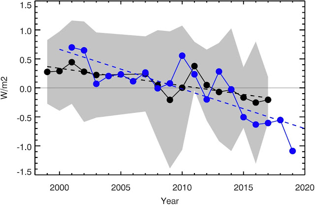
[ Earthshine annual albedo anomaly expressed as reflected flux in W/m². CERES data. ] 

The image below highlights the Pattern Effect of the Southern Ocean's committed warming (around -60°S) becoming more manifest over the years, as warming causes low-level clouds to disappear that reflect sunlight back. A 2021 study concludes this could make a difference of 0.7°C.

[ The Pattern Effect could account for a 0.7°C temperature rise. ]

5. ocean warming  ➭  stratification  ➭  less heat reaches deeper waters (feedback #29)

Higher sea surface temperatures come with greater stratification.

[ from earlier post ]

A recent study by Goreau et al. concludes:
Decreased vertical exchange in cold surface currents and in upwelling zones increases thermal stratification and slows down the Atlantic Meridional Overturning Circulation (AMOC), retains heat longer in the surface ocean, and reduces CO₂ exchange among the atmosphere, surface ocean, and the deep sea. The HotSpot maps from year to year suggest that upwelling systems can abruptly shut off, causing sudden sharp rises in regional air temperatures, and reducing air-ocean exchange of temperature and CO₂.

6. ocean currents and wind patterns change  ➭  less heat reaches deeper waters (feedback #19)

[ from earlier post ]
Oceans are still absorbing an estimated 91% of the excess heat energy trapped in the Earth's climate system due to human-caused global warming. If just a small part of that heat instead remains in the atmosphere, this could constitute a huge rise in the  temperature of the lower atmosphere.

Polar amplification of the temperature rise causes a relative slowing down of the speed at which heat flows from the Equator to the poles. This can affect ocean currents and wind patterns, resulting in slowing down of the Atlantic meridional overturning circulation (AMOC) and of ocean currents around Antarctica that carry heat to the deep ocean, as well as in deformation of the Jet Stream.

Another recent study warns about intensification of global warming due to the slowdown of the overturning circulation. The overturning circulation carries carbon dioxide and heat to the deep ocean, where it is stored and hidden from the atmosphere. As the ocean storage capacity is reduced, more carbon dioxide and heat are left in the atmosphere. This feedback accelerates global warming.

7. freshwater lid forms at ocean surface  ➭  more heat reaches Arctic Ocean (feedback #28)

Greater stratification, meltwater and rain can contribute to the formation of a freshwater lid that expands at the surface of the North Atlantic, enabling more ocean heat to travel underneath this lid from the North Atlantic into the Arctic Ocean, which can occur abruptly at times when a deformed Jet Stream causes storms that speed up ocean currents along this path.

8. Further mechanisms

8.1. El Niño and sunspots

Further mechanisms that could accelerate the temperature rise include a new El Niño in 2025, coinciding with a peak in sunspots that is higher than expected. The black dashed line in the image below, adapted from NOAA, indicates a transition to La Niña in October 2024, persisting through Jan-Mar 2025.


The image below shows the October 2024 IRI ENSO forecast. NOAA adds that the IRI plume predicts a weak and a short duration La Niña, as indicated by the Niño-3.4 index values less than -0.5°C.

[ IRI ENSO forecast from Oct 2024 ]

A new El Niño looks set to emerge soon and this may occur in the course of 2025, while Earth's Energy Imbalance is high (and rising), while feedbacks and other mechanisms add further heat and while sunspots reach a peak in this cycle (expected to occur in July 2025), all contributing to further accelerate the temperature rise.

[ click on images to enlarge ]

The above image, adapted from NOAA, illustrates that El Niño conditions were present from June 2023 through April 2024, and that ENSO-neutral conditions were present from May 2024 through September 2024.

8.2. Earth's Energy Imbalance and lack of political will to act

Earth's growing energy imbalance is perhaps the most obvious mechanism that increases the temperature. 


The image below, by Leon Simons, shows Earth's Energy Imbalance to April 2024 (12-month running mean) as the difference between absorbed and outgoing radiation. 


It's obvious that political action can and must improve Earth's Energy Imbalance, which can and must be achieved by reducing greenhouse gas emissions and further action, through transitions in energy use, agriculture, transport, etc. 

The IPCC has for many years weaved and twisted findings by scientists into a political narrative that downplays the temperature rise and refuses to point at the most effective measures to be taken to act on climate change, in an effort to create the illusion that there was a carbon budget to be divided among polluters as if pollution could continue for decades to come.

Lack of political will to act on the climate emergency is perhaps the most depressing mechanism accelerating the temperature rise. Moreover, where action is taken, blunt political instruments are all too often chosen that won't last long or turn out to be counter-productive. 

8.3. Aerosols

A further mechanism that could strongly accelerate the temperature rise is the falling away of the masking effect of aerosols currently emitted jointly with the greenhouse gases produced in the process of burning fossil fuel and biofuel. Blunt measures may be taken to reduce burning of fossil fuel and biofuel, which will reduce greenhouse gas emissions and also reduce emission of cooling aerosols, while such measures can at the same time encourage many to use more wood burners, thus also causing more warming aerosols to be emitted.

Sadly, few people are calling for more sophisticated measures, let alone for more effective measures such as local feebates. It is important to be open and clear as to what can and must be achieved and how, and why.  

Scientist warn that the combined impact of aerosols and nitrogen fertilizers has been underestimated; a recent study concludes that when ammonia, nitric acid and sulfuric acid are present together, they contribute strongly to the formation of cirrus clouds.

The IPCC image below shows how much temperatures are currently suppressed in the Arctic due to aerosols and thus also shows how much temperatures in the Arctic look set to rise as the aerosol masking effect falls away. 


8.4. Water vapor and the importance of the size of the temperature rise

The water vapor feedback is also getting stronger. The image below, created with NOAA data, shows surface precipitable water through September 2024. Note that values in 2024 are higher than in 2023. 

The image below, adapted from Climate Reanalyzer, shows the spread of the September 2024 anomaly in precipitable water, with less over the Amazon, but more over the Sahara, while more also shows up at higher northern latitudes, i.e. over the Barents Sea and the Canadian Arctic Archipelago. 


Since the water vapor feedback roughly follows the temperature rise (7% more water vapor for every 1°C warming), it's important to know the full rise from pre-industrial, as opposed to a rise calculated from a later base. If the temperature rise since pre-industrial is significantly larger, then the extra water wapor feedback will accordingly be larger. 

A lot of the extra water vapor gets into the atmosphere through evaporation from oceans, but a significant part also comes from land and water bodies on land. A lot of energy gets consumed in the process of evaporation from land and lakes and in the process of thawing of permafrost. Water that previously remained present in the ground, is increasingly moving up into the atmosphere. The water vapor feedback results in more moisture getting sucked up into the air as temperatures rise, a process that can be further accelerated by stronger wind as temperatures rise.

The image on the right shows shallow groundwater storage in most of South America for the week of October 7, 2024, as measured by the Gravity Recovery and Climate Experiment Follow-On (GRACE-FO) satellites (NASA image, discussed on facebook). 

The image illustrates the danger of the Land Evaporation Tipping Point getting crossed locally when water is no longer available locally for further evapotranspiration, i.e. from all processes by which water moves from the land surface to the atmosphere via evaporation and transpiration, including transpiration from vegetation, evaporation from the soil surface, from the capillary fringe of the groundwater table, and from water bodies on land. Once this tipping point gets crossed, the land and atmosphere will heat up strongly, due to the extra heat, i.e. heat that was previously consumed by evaporation and thawing. Additionally, more water vapor in the atmosphere accelerates the temperature rise, since water vapor is a potent greenhouse gas and this also contributes to speeding up the temperature rise of the atmosphere.

Similarly, the rise to come (over the next few years) could be significantly larger than expected, e.g. due to the above seven mechanisms relating to changes in snow & ice, winds and oceans, in which case the extra water vapor will accordingly be larger. 

The image below shows the global September 2024 sea surface temperature anomaly (versus 1951-1980, ERA5 data, adapted from Climate Reanalyzer). 


The image below shows that the September 2024 sea surface temperature anomaly (versus 1951-1980) was at a record high, in a tie with October 2023, in the area between latitudes 10°North and 40°North. 


The image below shows that the September 2024 total column precipitable water anomaly (versus 1951-1980, ERA5 data) was at a record high in the area between latitudes 10°North and 40°North. 


8.5. Tipping points

Loss of Arctic sea ice and loss of Permafrost in Siberia and North America can be regarded both as feedbacks and as tipping points. Loss of Antarctic sea ice and loss of the snow and ice cover on land elsewhere (on Greenland, on Antarctica and on mountaintops such as the Tibetan Plateau) can also be regarded as tipping points. 

What makes them tipping points is that, once the snow and ice cover has disappeared and the ice in the soil has melted, further heat can no longer be consumed in the process of melting or thawing, resulting in a sudden local temperature rise that spreads to neighboring areas. 

As temperatures keep rising, this could cause a second Blue Ocean Event to occur in 2025, i.e. in the Arctic. Subsequently, as the oceans keep heating up, the seafloor methane tipping point could be crossed. 

The image below lists 14 events. Note that the 14 mechanisms below are from an earlier post and many mechanisms differ from the above 8 mechanisms. Note also that the order may differ and that, instead of one domino tipping over the next one sequentially, many events may occur simultaneously and reinforce each other in the speed at which they unfold and the temperature rise that results. There could be interaction and amplification between mechanisms, resulting in a huge abrupt acceleration of the temperature rise that leads to extinction of most species, including humans, as the image below warns, from an earlier post. Finally, note that there could be Black Swan Events that have not yet been identified. 

[ from earlier post - click on images to enlarge ]

Seven important tipping points are:
- The Latent Heat Tipping Point (feedback #14, as discussed above)
- The Seafloor Methane Tipping Point (feedback #16)
- The Clouds Tipping Point (also clouds feedback #30)
- The Terrestrial Biosphere Temperature Tipping Point
- The Ocean Surface Tipping Point (also discussed at facebook)
- The Land Evaporation Tipping Point (discussed above, also discussed at facebook)
- The Aquatic Deoxygenation Tipping Point (also discussed at facebook)

[ for more background, also view the Extinction page ]
A huge temperature rise could occur soon

A huge temperature rise could occur soon, as the impact of these mechanisms keeps growing, as the latent heat tipping point gets crossed in a Double Blue Ocean Event and the seafloor methane tipping point subsequently gets crossed. 

As temperatures keep rising in the Arctic, changes to the Jet Stream look set to intensify, resulting in loss of terrestrial albedo in the Arctic that could equal the albedo loss resulting from sea ice decline.

Further feedbacks include permafrost degradation, both terrestrial and on the seafloor of the Arctic Ocean, which looks set to cause huge releases of greenhouse gases (particularly CO₂, CH₄ and N₂O).

This would in turn also cause more water vapor to enter the atmosphere, further speeding up the temperature rise. 

The danger of a huge temperature rise is very large in the Arctic, where vast amounts of methane are held in sediments at the seafloor and in permafrost on land, and where there is very little hydroxyl in the air to break down the methane.

Climate Emergency Declaration

The situation is dire and the precautionary principle calls for rapid, comprehensive and effective action to reduce the damage and to improve the situation, as described in this 2022 post, where needed in combination with a Climate Emergency Declaration, as discussed at this group.


Links

• Arctic Data archive System - National Institute of Polar Research - Japan
https://ads.nipr.ac.jp/vishop

• Danish Meteorological Institute - Arctic sea ice volume and thickness
https://ocean.dmi.dk/arctic/icethickness/thk.uk.php

• University of Bremen - Arctic sea ice
https://seaice.uni-bremen.de/start

• NSIDC - Interactive sea ice chart
https://nsidc.org/arcticseaicenews/charctic-interactive-sea-ice-graph

• Climate Reanalyzer

• Copernicus

• Earth's Sea Ice Radiative Effect From 1980 to 2023 - by Duspayev et al. (2024) 
• NOAA - Climate Prediction Center - ENSO: Recent Evolution, Current Status and Predictions
https://www.cpc.ncep.noaa.gov/products/analysis_monitoring/lanina/enso_evolution-status-fcsts-web.pdf

• NOAA - Physical Sciences Laboratory
https://psl.noaa.gov

• NASA 
https://data.giss.nasa.gov

• Indicators of Global Climate Change 2023: annual update of key indicators of the state of the climate system and human influence - by Piers Forster et al. 
https://essd.copernicus.org/articles/16/2625/2024

• 2023 Record marine heat waves: coral reef bleaching HotSpot maps reveal global sea surface temperature extremes, coral mortality, and ocean circulation changes - by Thomas Goreau et al. 
https://academic.oup.com/oocc/article/4/1/kgae005/7666987

• Feedbacks
https://arctic-news.blogspot.com/p/feedbacks.html

• Jet Stream
https://arctic-news.blogspot.com/p/jet-stream.html

• Freshwater lid on the North Atlantic
https://arctic-news.blogspot.com/p/cold-freshwater-lid-on-north-atlantic.html

• Latent Heat
https://arctic-news.blogspot.com/p/latent-heat.html

• Sunspots
https://arctic-news.blogspot.com/p/sunspots.html

• Indicators of Global Climate Change 2023: annual update of key indicators of the state of the climate system and human influence - by Piers Forster et al.