Surface Temperature (ST) and Sea surface Temperature (SST) including Sea surface Temperature Anomaly (SSTA)
Northern Hemisphere SSTA
Above image shows sea surface temperature anomalies on the Northern Hemisphere, with a polynomial trend pointing at a doubling of ocean warming within one decade.
From the post 'Pursuing efforts?', at:
http://arctic-news.blogspot.com/2016/10/pursuing-efforts.html
Northern Hemisphere SSTA
The image below illustrates how much and how fast oceans are warming on the Northern Hemisphere.
 |
| Trend points at 1.5°C warmer NH oceans in 2025. Shaded area covers seasonal fluctuations and natural variability. |
https://arctic-news.blogspot.com/2017/05/arctic-warming-update-may-2017.html
Below from: Greenhouse Gas Levels Keep Accelerating
Below from: High Temperatures Over Arctic Ocean In June 2018
Below from: Doomsday by 2021?
https://arctic-news.blogspot.com/2018/11/doomsday-by-2021.html
Here's how. As above image shows, oceans continue to warm up, due to the rise in greenhouse gas levels in the atmosphere.
The image on the right shows sea surface temperature anomalies as high as as 7.1°C (or 12.7°F) in the Bering Strait (at the green circle) on October 15, 2018.
Warmer oceans result in stronger cyclones. The next image on the right shows that Typhoon Yutu was forecast to reach an Instantaneous Wind Power Density (WPD) as high as 207647 W/m² at 850 mb and wind speeds as fast as 268 km/h or 167 mph at the green circle, i.e. at 18.50° N, 124.00° E, on October 30, 2018, 00:00 UTC.
Cyclones can suddenly push huge amounts of salty warm water into the Arctic Ocean. The danger is that a strong influx of salty warm water into the Arctic Ocean could trigger destabilization of hydrates in sediments, resulting in massive eruptions of methane from the seafloor of the Arctic Ocean, as described in earlier posts such as this one.
This methane could cause temperatures to suddenly rise strongly at the higher latitudes of the Northern Hemisphere, speeding up decline of sea ice and permafrost, and further deforming the jet stream.
SSTA - Lena River, Siberia
Warm water from rivers is flowing into the Arctic Ocean, carrying further heat into the Arctic Ocean.
Above image shows that on June 23, 2021, sea surface temperatures were 22.3°C or 72.2°F at a spot where water from the Lena River flows into the Arctic Ocean.
The image on the right shows that at a nearby location the sea surface temperature was 20°C or 36°F higher than 1981-2011.
From:
Heatwaves and the danger of the Arctic Ocean heating up
Heatwaves and the danger of the Arctic Ocean heating up
SST NEAR SVALBARD
August 13, 2018
SSTA: 16.4°C or 29.5°F warmer than during 1981-2011
SST: 22°C or 71.6°F (record high) on August 13, 2018
from:
Peaks Matter
As illustrated by above image, the sea surface near Svalbard was 22°C or 71.6°F at the green circle on August 13, 2018, i.e. 16.4°C or 29.5°F warmer than 1981-2011.
SSTA NEAR SVALBARD
December 8, 2018
SSTA: 18.2°C or 32.7°F warmer than during 1981-2011 (record high) on December 8, 2018
SST: 20.7°C or 69.3°F
from:
Dangerous situation in Arctic
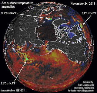 In the North Pacific, the flow of warmer water is clearly visible (see images right, green circle left).
In the North Atlantic, huge amounts of heat are moving into the Arctic Ocean (green circle right).
At some spots, heat that is traveling underneath the sea surface comes to the surface (green circle at the top).
Most warming caused by people's emissions goes into oceans, especially into the top layer of oceans.
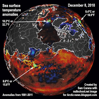 Furthermore, warmer air and warmer sea surfaces can cause winds to grow dramatically stronger. As the Arctic is warming much faster than the rest of the world, the narrowing difference between the temperatures at the North Pole and the Equator is decreasing the speed at which winds circumnavigate Earth; at the same time, the amount of heat that is moving north can grow dramatically, both due to winds and sea currents, and cyclones can further accelerate this.
The danger is that an influx of warm salty water will reach the seafloor and trigger methane eruptions.
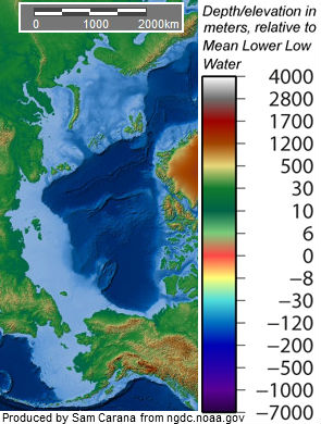 The situation is especially critical in many parts of the Arctic Ocean where the water is very shallow. Some 75% of the East Siberian Arctic Shelf (ESAS) is shallower than 50 m (see maps on the right).
 |
| [ warm water from the Atlantic Ocean is increasingly invading the Arctic Ocean ] |

The danger here is huge, for numerous reasons, incl.:
• shallow waters can warm up very rapidly in case of an influx of warm water;
• these shallow seas are now covered by ice, so the heat cannot escape to the atmosphere;
• sea ice is very thin, so the sea ice won't act as a buffer to absorb the heat;
• methane rising through shallow waters will pass through the water column and enter the atmosphere more quickly;
• in shallow waters, large abrupt releases will more quickly deplete the oxygen in the water, making it harder for microbes to break down the methane;
• hydroxyl levels over the Arctic are very low, which means that it takes much longer for methane over the Arctic to get broken down.
The four videos below provide a good introduction into the various issues and illustrate how dangerous the situation is in the Arctic.
Each video is part of a talk between Dave Borlace and Peter Wadhams.
Heat threatens to destabilize methane hydrates
As discussed in earlier posts such as this one, this heat threatens to destabilize methane hydrates contained in sediments at the seafloor of the Arctic Ocean.
As the panel on the left shows, sea surface temperatures in the Bering Strait were as much as 15.1°C or 27.2°F hotter than 1981-2011 on June 20, 2020 (in Norton Sound, Alaska, at the green circle).
The bathymetry map in the right panel of above image shows how shallow seas in the Arctic Ocean can be. The water over the ESAS is quite shallow, making that the water can warm up very quickly during summer heat peaks and heat can reach the seafloor, which comes with the risk that heat will penetrate cracks in sediments at the seafloor. Melting of ice in such cracks can lead to abrupt destabilization of methane hydrates contained in sediments.
Large abrupt methane releases will quickly deplete the oxygen in shallow waters, making it harder for microbes to break down the methane, while methane rising through waters that are shallow can enter the atmosphere very quickly.
The situation is extremely dangerous, given the vast amounts of methane present in sediments in the ESAS, given the high global warming potential (GWP) of methane following release and given that over the Arctic there is very little hydroxyl in the air to break down the methane.
 |
| [ from earlier post ] |
From:
2020 Siberian Heatwave continues
https://arctic-news.blogspot.com/2020/06/2020-siberian-heatwave-continues.html
High greenhouse gas levels are causing high temperatures over the Arctic and high ocean temperatures.
On July 25, 2020, sea surface temperatures in the Arctic Ocean were as high as 20.8°C or 69.4°F (at the green circle on above image).
At that same location, on July 22, 2020, sea surface temperatures in the Arctic Ocean were as much as 17°C or 30.5°F higher than the daily average during the years 1981-2011.
This location is where the Pechora River flows into the Barents Sea (the green circle pointed at by the white arrow on above image).
As the image below shows, sea surface temperatures in the Arctic Ocean on August 1, 2020, were as much as 11.5°C or 20.7°F higher than 1981-2011 (at green circle, off the coast of Siberia, opposite Greenland).
From:
Arctic sea ice could disappear completely within two months' time
https://arctic-news.blogspot.com/2020/07/arctic-sea-ice-could-disappear-completely-within-two-months-time.html
October 31, 2016
SSTA: 13.9°C
SST: 17°C
On October 31, 2016, the Arctic Ocean was as warm as 17°C or 62.7°F (green circle near Svalbard), or 13.9°C or 25°F warmer than 1981-2011. This indicates how much warmer the water is beneath the surface, as it arrives in the Arctic Ocean from the Atlantic Ocean.
From the post 'Less sea ice, warmer Arctic Ocean', at:
http://arctic-news.blogspot.com/2016/11/less-sea-ice-warmer-arctic-ocean.html
August 12, 2016
SSTA: 13.6°C
SST: 18.9°C
 |
| Sea surface temperature and anomaly. Anomalies from +1°C to +2°C are red, above that they turn yellow and white |
From the post 'Wildfires in Russia's Far East', at:
https://arctic-news.blogspot.com/2016/08/wildfires-in-russias-far-east.html
HOT SPOT Svalbard Left
SSTA 10.4°C or 18.7°F Jan 24, 2016
SST 12.3°C or 54.2°F
used at:
Arctic sea ice area at record low for time of year
HOT SPOT Svalbard right
SSTA 9.4°C or 17°F Jan 25, 2016
SST 10.7°C or 51.3°F
SSTA off the east coast of North America
HOT SPOT off coast NA
SSTA 10.3°C or 18.5°F Dec 11, 2015
SST 20.8°C or 69.4°F
features at:
2015 warmest year on record
SSTA 12.7°C or 21.8°F Nov 27, 2020
The image below shows sea surface temperature anomalies compared to 1981-2011 on the Northern Hemisphere on October 23, 2020, when anomalies off the coast of North America were as high as 10.8°C or 19.5°F (left), and on December 3, 2020, when anomalies off the coast of North America were as high as 12.7°C or 22.8°F (right).
From the post 'Above Zero Celsius at North Pole November 2020', at:
https://arctic-news.blogspot.com/2020/11/above-zero-celsius-at-north-pole-november-2020.html
GULF STREAM Jan 7, 2016
8.2 °C or 14.7 °F January 7, 2016 warm spot Gulf Stream
https://arctic-news.blogspot.com/2020/11/above-zero-celsius-at-north-pole-november-2020.html
GULF STREAM Jan 7, 2016
8.2 °C or 14.7 °F January 7, 2016 warm spot Gulf Stream
The image below shows that sea surface temperatures were as much as 14.1°C or 25.3°F higher than 1981-2011 off the North American coast (green circle) on March 5, 2022.
From the post 'Signs of the rise to come', at:The image below shows that sea surface temperatures were as much as 14.8°C or 26.6°F higher than 1981-2011 off the North American coast (green circle) on May 17, 2022.
Ocean heat is carried along the path of the Gulf Stream into the Arctic Ocean, melting Arctic sea ice.
Ocean heat is carried along the path of the Gulf Stream into the Arctic Ocean, melting Arctic sea ice.
Above image from: Ten temperature rise indications, at:
https://arctic-news.blogspot.com/p/ten-temperature-rise-indications.html
https://arctic-news.blogspot.com/p/ten-temperature-rise-indications.html
2. Ocean Heat
Above image shows the worrying rise of Northern Hemisphere sea surface temperature anomalies from the 20th century average, with the added trend illustrating the danger that this rise will lead to Arctic sea ice collapse and large methane eruptions from the seafloor of the Arctic Ocean, further accelerating the temperature rise. From the post July 2019 Hottest Month On Record.
The image below shows a trend (based on 1880-2020 data) for sea surface temperature anomalies (versus the 20th century average) on the Northern Hemisphere. Note that the image indicates that the latent heat tipping point was crossed in the year 2020.
https://arctic-news.blogspot.com/p/ten-temperature-rise-indications.html
Content below from the page The Mechanism, at:
http://arctic-news.blogspot.com/p/the-mechanism.html
 |
| [ click on image to enlarge, from: The Great Unraveling ] |
Waters at greater depth are also warming rapidly, as illustrated by the image on the right, from an earlier post, showing a rise in ocean heat up to 2000 m deep that has more than doubled over the past decade.
Data from 2005 through to 2014 contain a polynomial trendline that points at a similar rise by 2017, followed by an even steeper rise.
The North Atlantic is warming rapidly, with sea surface temperatures as high as 22.2°C (71.96°F) recorded east of North America on April 11, 2015, a 12.6°C (22.68°F) anomaly, at a location marked by the green circle on above image.
A warmer North Atlantic is a major contributor to the rapidly warming waters of the Arctic Ocean, since the Gulf Stream keeps carrying warmer water into the Arctic Ocean all year long.
Ocean heat is carried by the Gulf Stream from Florida via the North Atlantic into the Arctic Ocean.
The huge amounts of energy entering the oceans translate into higher temperatures of the water and of the air over the water, as well as higher waves and stronger winds.
 |
The image below shows sea surface temperatures with the scale going up to 35°C on August 22, 2015, indicating that a huge amount of ocean heat has accumulated in the Atlantic Ocean off the east coast of North America.
The image below gives a further idea of how much the water in the Gulf Stream is heating up, compared to how it used to be. On August 22, 2015, at a location near Florida marked by the green circle, sea surface temperatures were as high as 33.4°C (92.1°F), an anomaly of 3.8°C (6.8°F), versus 1981-2011.
The image below shows that on September 1, 2014, a sea surface temperature of 17.5°C (63.5°F) was recorded at a location near Svalbard (green circle, co-ordinates in the black panel on the left), a 11.9°C (21.42°F) anomaly.
As the bottom part of above image shows, sea surface temperatures around that location were substantially colder, indicating that this 17.5°C surface temperature was caused by ocean heat reaching that location from underneath the sea surface.
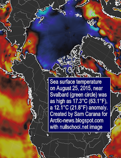 In other words, subsurface temperatures of the water carried along by the Gulf Stream can be substantially higher than temperatures of the water at the surface, and this can be the case for the water all the way from the coast of North America to the Arctic Ocean.
Warm water carried by the Gulf Stream underneath the ocean surface will come to the surface where the sea is rather shallow.
This appears to be confirmed by the image on the left, showing the situation on August 25, 2015, when sea surface temperatures near Svalbard were recorded as high as 17.3°C (63.1°F), as marked by the green circle, a 12.1°C (21.8°F) anomaly.
The Gulf Stream keeps pushing much of this very warm water north, into the Arctic Ocean, where it threatens to unleash huge methane eruptions from the Arctic Ocean seafloor.
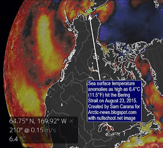 A further contributor is a warmer North Pacific. The image on the right shows very high sea surface temperature anomalies around North America. On August 23, 2015, sea surface temperature anomalies as high as 6.4°C (11.5°F) were recorded in the Bering Strait, at a location marked by the green circle. This is where warm waters from the Pacific Ocean are flowing into the Arctic Ocean.
 Further contributions come from the combined impact of numerous feedbacks, in particular changing winds and currents, cryosphere changes and methane releases, as further described below.
Below from: Alaska On Fire
https://arctic-news.blogspot.com/2019/07/alaska-on-fire.html
Sea surface temperatures in the Bering Sea were as high as 21.6°C or 70.88°F on July 15, 2019.
Warm water from rivers flowing into the Bering Strait have contributed to some of the high temperatures of the water near the coast of Alaska.
Furthermore, as the June 21, 2019, image below shows, sea surface temperature anomalies have also been high around Alaska further away from the coast.
Indeed, more than 90% of the extra energy caused by humans goes into oceans, and sea currents carry a lot of this extra heat toward the Arctic Ocean.
The image below shows sea surface temperature anomalies around Alaska on July 11, 2019, with an anomaly of 7.7°C or 13.8°F compared to 1981-2011 showing up north of Alaska in the Arctic Ocean. The light blue areas indicate sea surface that is colder, due to heavy melting of the sea ice in those areas.
The image below shows sea surface temperature anomalies as high as 14°C or 25.1°F compared to 1981-2011 in the Bering Strait on June 17, 2020 (at the green circle).
From the post:
2020 Siberian Heatwave continues
https://arctic-news.blogspot.com/2020/06/fast-path-to-extinction.html
Forecast of hourly temperature anomalies for the Arctic and daily average temperature anomalies.
The image below shows that, on March 16, 2022, the daily average temperature in the Arctic was 3.5°C higher than 1979-2000.
From the post:
Signs of the rise to comehttps://arctic-news.blogspot.com/2022/03/signs-of-rise-to-come.html
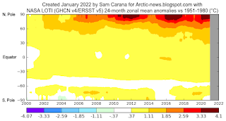
This is illustrated by the image on the right, created with a NASA image that shows temperature anomalies of up to 4.1°C (versus 1951-1980) over the Arctic Ocean.
The next image on the right, by Climate Reanalyzer, illustrates that very high temperature anomalies can show up at the highest latitudes North during Winter on the Northern Hemisphere, in this case a temperature anomaly (vs 1979-2000) of 7°C for the Arctic as a whole on February 28, 2022.
It is ominous for such high anomalies to show up in the Arctic during a La Niña period, and when it's Winter on the Northern Hemisphere when there's only very little sunlight reaching the Arctic.
For comparison, the next image on the right shows a temperature anomaly (vs 1979-2000) of 7.7°C for the Arctic as a whole on November 18, 2016, when there was an El Niño.
We're currently in the depth of a persistent La Niña, as illustrated by the next image on the right, adapted from NOAA. This has been suppressing the temperature and it will keep suppressing the temperature until the start of the next El Niño. The next El Niño could push temperatures up even more strongly than the average El Niño, for a number of reasons.
From:
Daily Reanalysis, SST, & Sea Ice Maps
Forecasts of hourly temperature anomalies can be even higher than daily average temperatures.
end
The highest temperature anomalies have over the years shown up at the highest latitudes North, i.e. the Arctic Ocean, in particular during El Niño periods.
This is illustrated by the image on the right, created with a NASA image that shows temperature anomalies of up to 4.1°C (versus 1951-1980) over the Arctic Ocean.
It is ominous for such high anomalies to show up in the Arctic during a La Niña period, and when it's Winter on the Northern Hemisphere when there's only very little sunlight reaching the Arctic.
We're currently in the depth of a persistent La Niña, as illustrated by the next image on the right, adapted from NOAA. This has been suppressing the temperature and it will keep suppressing the temperature until the start of the next El Niño. The next El Niño could push temperatures up even more strongly than the average El Niño, for a number of reasons.
From the post:
Signs of the rise to comeThe image below shows that, on November 19, 2016, the daily average temperature in the Arctic was 8°C higher than 1979-2000.
Daily Reanalysis, SST, & Sea Ice Maps
Forecasts of hourly temperature anomalies can be even higher than daily average temperatures.
The forecast for 6:00 UTC on February 23, 2016, shows an anomaly of 8.17°C or 14.71°F.
Temperatures in January 2016 over the Arctic Ocean were 7.3°C (13.1°F) higher than in 1951-1980, according to NASA data, as illustrated by the graph on the right, from an earlier post.
These high temperatures go hand in hand with sea ice extent that is much lower for this time of year than since records started.
As discussed in an earlier post, low sea ice extent is fuelling fears that this year's maximum extent was already reached on February 9, 2016.
From the post:
Arctic Winter Heatwave
end




No comments:
New comments are not allowed.