Showing posts with label jet stream. Show all posts

Thursday, December 22, 2022

Wild Winter Weather

[ posted earlier at facebook ]
The image on the right shows a forecast of very low temperatures over North America with a temperature of -40 °C / °F highlighted (green circle at center) for December 23, 2022 14:00 UTC. 

As the image shows, temperatures over large parts of North America are forecast to be even lower than the temperature at the North Pole.  

The combination image below illustrates this further, showing temperatures as low as -50.3°C or -58.6°F in Alaska on December 22, 2022 at 17:00 UTC, while at the same time the temperature at the North Pole was -13.6°C or 7.4°F. 


The Jet Stream

The image below shows the Jet Stream (250 hPa) on December 13, 2022, stretched out vertically and reaching the North Pole as well as the South Pole, while sea surface temperature anomalies are as high as 11°C or 19.7°F from 1981-2011 at the green circle. 

The Jet Stream used to circumnavigate the globe within a narrow band from West to East (due to the Coriolis Force), and it used to travel at relatively high speed, fuelled by the temperature difference between the tropics and the poles.

[ posted earlier at facebook ]

The Jet Stream used to circumnavigate the globe within a narrow band from West to East (due to the Coriolis Force), and it used to travel at relatively high speed, fuelled by the temperature difference between the tropics and the poles. 

As the above image shows, the Pacific Ocean is currently cooler at the tropics and warmer further to the north (compared to 1981-2011), which narrows this temperature difference and in turn makes the Jet Stream wavier. Accordingly, the Jet Stream is going up high into the Arctic before descending deep down over North America. 


[ click omn images to enlarge ]
The above image shows Rossby waves, from NOAA. When you see a wave traveling along the surface of water, there are peaks and troughs in the water height. The same happens in the atmosphere with a traveling Rossby wave – as the Rossby wave travels through the atmosphere, the peaks and troughs of the wave produce regions of high and low air pressure.

The image on the right shows air pressure at sea level on December 22, 2022. High sea surface temperatures make air rise, lowering air pressure at the surface to levels as low as 973 hPa over the Pacific. Conversely, a more wavy Jet Stream enables cooler air to flow from the Arctic to North America, raising air pressure at the surface to levels as high as 1056 hPa.

On December 22, 2022, the Jet Stream reached very high speeds over the Pacific, fuelled by high sea surface temperature anomalies. The image on the right shows the Jet Stream moving over the North Pacific at speeds as high as 437 km/h or 271 mph (with a Wind Power Density of 349.2 kW/m², at the green circle). 

The Jet Stream then collides with higher air pressure and moves up into the Arctic, and subsequently descends deep down over North America, carrying along cold air from the Arctic. Deformation of the Jet Stream also results in the formation of circular wind patterns that further accelerate the speed of the Jet Stream. 

The image on the right shows the Jet Stream moving over North America at speeds as high as 366 km/h or 227 mph (green circle). The image also shows high waves in the North Pacific. 

La Niña / El Niño

The low sea surface temperature anomalies in the Pacific Ocean are in line with the current La Niña. 

The fact that such extreme weather events occur while we're in the depth of a persistent La Niña is worrying. The next El Niño could push up temperatures further, which would hit the Arctic most strongly. This would further narrow the difference between temperatures at the Equator and the North Pole, thus making the Jet Stream more wavy, which also enables warm air to move into the Arctic, further accelerating feedbacks in the Arctic.

The image below, from NOAA, indicates that the next El Niño is likely to emerge soon. More about that in the next post. 


Conclusion

The situation is dire and calls for immediate, comprehensive and effective action as described in the Climate Plan


Links

• nullschool

• Jet Stream

• Coriolis Force

• NOAA - What are teleconnections? Connecting Earth's climate patterns via global information superhighways

• Wind Power Density

• Extreme Weather
https://arctic-news.blogspot.com/p/extreme-weather.html

• Feedbacks in the Arctic
https://arctic-news.blogspot.com/p/feedbacks.html

• NOAA - Multivariate ENSO Index Version 2 (MEI.v2)


Thursday, September 29, 2022

Crossing 3C

The Northern Hemisphere is where most people live. Furthermore, most people live on land. Let's first look at the temperature rise on the Northern Hemisphere. 

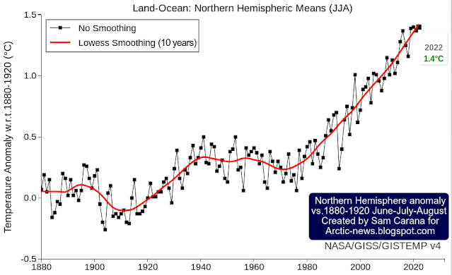
The image below, created with a September 30, 2022 screenshot from NASA customized analysis plots, shows June-July-August temperature anomalies from 1880-1920 on the Northern Hemisphere with June-July-August 2022 highlighted with an anomaly of 1.4°C or 2.52°F, a record high in a tie with 2020. 


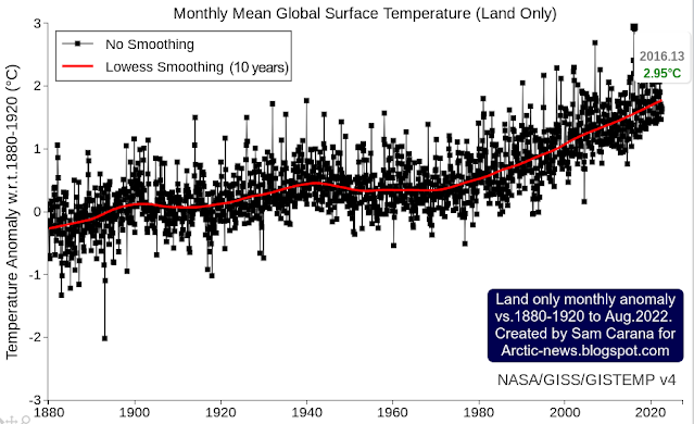
Secondly, most people live on land. The image below shows the monthly mean global surface temperature anomaly on land. It is similarly created with a September 30, 2022 screenshot from NASA customized analysis plots and shows a peak anomaly from 1880-1920 of 2.95°C or 5.31°F (for February 2016, land only).


The year 2016 was an El Niño year. During an El Niño, temperatures are higher than usual. We are currently in the depths of a persistent La Niña, which suppresses temperatures. We look set to move into another El Niño within years. 

In conclusion, the temperature rise on land on the Northern Hemisphere looks set to cross 3°C soon, the more so since we are also facing a peak in sunspots (by 2025), which may coincide with peak temperatures associated with the upcoming El Niño. Also keep in mind that the above temperature anomalies are measured from 1880-1920, so the temperature rise from pre-industrial is significantly higher than that. 


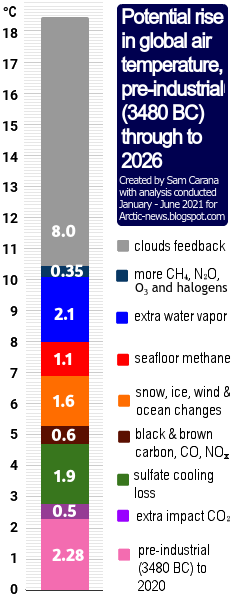
There are further events and developments that could additionally speed up the temperature rise, as discussed at the extinction page. Humans are likely to go extinct with a rise of 3°C, as illustrated by the above image, from an analysis discussed in an earlier post.

Methane levels keep rising

The image below, from an earlier post, shows annual global mean methane with a trend added that points at a methane rise that could in 2028 represent a forcing of 780 ppm CO₂e (with a 1-year GWP of 200).

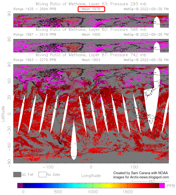
In other words, the clouds tipping point at 1200 ppm CO₂e could be crossed in 2028 due to the forcing of methane and CO₂ alone, assuming that CO₂ concentration in 2028 will exceed 420 ppm. Moreover, this could happen even earlier, since there are further forcers, while there also are further events and developments that could additionally speed up the temperature rise, as discussed in earlier posts such as this one. Furthermore, the NOAA data used in the above image rise are for marine surface measurements. Methane is accumulating at higher altitude, as illustrated by the compilation images below. 


The top image of above compilation image shows that the MetOp-B (also known as MetOp-1) satellite recorded a mean methane concentration of 1979 parts per billion (ppb) at 293 mb on September 30, 2022 pm. 

The above compilation image shows high concentrations of methane close to sea level, all the way up to the Tropopause. Does this indicate that methane is rising up from the seafloor of the Arctic Ocean?  

Polar Jet Stream (blue) and Subtropical
Jet Stream (red) - NOAA image
Let's first take a look at prevailing wind pattern and how they changed. On the Northern Hemisphere, the coldest point used to be the North Pole, so wind used to flow from the tropics to the North Pole.

This and the deflection due to the Coriolis force resulted in two Jet Streams forming, circumnavigating the globe in what used to be narrow and straight bands, i.e. the Polar Jet Stream at 60° North and the Subtropical Jet Stream at about 30°, both on the Northern and Southern Hemisphere, resulting in a total of four Jet Streams.

The Jet Stream used to circumnavigate the globe in narrow and straight bands, predominantly following a path from East to West, in line with its strength and with this deflection.

Polar Jet Stream and Subtropical Jet Stream - NOAA image
The Jet Stream used to circumnavigate the globe at specific latitudes, as illustrated by the images on the right.

Prevailing wind patterns cause carbon dioxide to accumulate at the poles, as illustrated by the image underneath on the right that shows a high carbon dioxide concentration of 235 ppm over the North Pole. 

Some things changed as, due to emissions by people, the difference in temperature between the Arctic and the Tropics narrowed. 

This decreases the speed at which heat is moving to the North on the Northern Hemisphere and it deforms the Jet Stream and the prevailing wind patterns, which can make it even more easy for methane that is released from the Arctic Ocean to rise up and accumulate at the Tropopause, and move from there toward the Equator as it rises. 

Emissions by people are also causing the Troposhere to expand. 

Note the important difference in weight between carbon dioxide and methane. Carbon dioxide tends to accumulate at lower altitudes since it is heavier than air. Methane, on the other hand, is lighter than air, causing methane to rise and accumulate at altitudes near the Tropopause, from where methane moves closer to the Equator, since the Tropopause is higher in altitude at the Tropics than at the Poles. 

The accumulation of methane at higher altitudes is further illustrated in the compilation image below that shows that methane mean levels are highest where the troposphere ends over the Arctic. 


The situation is dire and the right thing to do now is to help avoid or delay the worst from happening, through action as described in the Climate Plan.


Links

• NASA - GISS Surface Temperature Analysis
https://data.giss.nasa.gov/gistemp/graphs_v4/customize.html

• Cataclysmic Alignment
https://arctic-news.blogspot.com/2022/06/cataclysmic-alignment.html

• Sunspots
https://arctic-news.blogspot.com/p/sunspots.html

• Pre-industrial
https://arctic-news.blogspot.com/p/pre-industrial.html

• When will we die?
https://arctic-news.blogspot.com/2019/06/when-will-we-die.html

• Extinction
https://arctic-news.blogspot.com/p/extinction.html

• Blue Ocean Event 2022?

• Jet Stream

• nullschool.net

Friday, March 18, 2022

Signs of the rise to come

Arctic sea ice extent has fallen strongly over the past few weeks and looks set to keep falling rapidly over the next few months. 


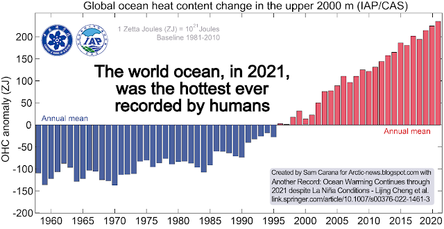
Ocean heat is at record levels, as illustrated by the image below and as discussed in an earlier post


The image below shows the temperature at the North Pole reaching 0.7°C or 33.3°F (at 1000 hPa, at the green circle) on March 16, 2022, with ocean currents depicted at the background.


How could the temperature at the North Pole get this high, in March? 

As said, ocean heat is at record levels. This is heating up the air over the Atlantic Ocean. At times, huge amounts of heat are getting pushed into the Arctic due to a distorted Jet Stream. The image on the right shows the Jet Stream on the Northern Hemisphere on March 16, 2022, with strong winds at 250 hPa pushing heat from the Atlantic Ocean into the Arctic.

Furthermore, the Gulf Stream is pushing huge amounts of ocean heat toward the Arctic. 

The image below shows that sea surface temperatures were as much as 14.1°C or 25.3°F higher than 1981-2011 off the North American coast (green circle) on March 5, 2022.


The image below shows that, on March 16, 2022, the temperature in the Arctic was 3.5°C higher than 1979-2000. 


Below, a Climate Reanalyzer forecast for March 18, 2022, of very high temperature anomalies over Antarctica combined with a forecast of a diversion over Antarctica of the Southern Polar Jet Stream (wind at 250 hPa).


As the combination image below shows, the temperature on Antarctica was 12.5°C or 54.4°F at 1000 hPa at the green circle on March 17, 2022 at 17:00 UTC. The image in the left panel shows high sea surface temperature anomalies south of Australia, while the Jet Stream (250 hPa) moves over Antarctica. The image in the right panel shows wind and temperature at 1000 hPa. 


What causes such distortions of the Jet Stream?

• Emissions by people heat up the air, and heat up oceans and make winds stronger, as discussed in an earlier post.

• Another mechanism affecting the Jet Stream is that, as oceans heat up, the temperature difference between land and oceans widens both in Summer and in Winter and this can cause the Jet Stream to divert deeper from the narrow path it used to follow, as discussed in an earlier post

• What especially affects the Jet Stream on the Northern Hemisphere is that, as the Arctic gets hit hard by temperature rises, the temperature difference narrows between the Arctic and the Equator, slowing the Jet Stream; this can prolong and amplify extreme weather events.


Signs of the things to come

The above events could be seen as signs of the strength and the speed of the rise to come.  


Rise due to La Niña and high sunspots

The image below indicates that the global temperature difference between the top of an El Niño and the bottom of a La Niña period could be more than half a degree Celsius.


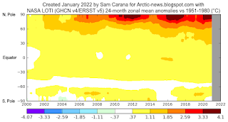
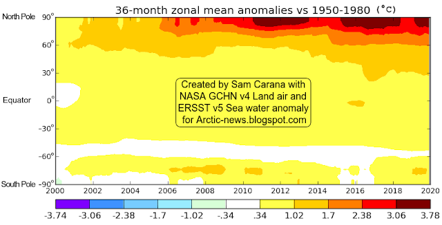
The highest temperature anomalies have over the years shown up at the highest latitudes North, i.e. the Arctic Ocean, in particular during El Niño periods.

This is illustrated by the image on the right, created with a NASA image that shows temperature anomalies of up to 4.1°C (versus 1951-1980) over the Arctic Ocean.

The next image on the right, by Climate Reanalyzer, illustrates that very high temperature anomalies can show up at the highest latitudes North during Winter on the Northern Hemisphere, in this case a temperature anomaly (vs 1979-2000) of 7°C for the Arctic as a whole on February 28, 2022. 

It is ominous for such high anomalies to show up in the Arctic during a La Niña period, and when it's Winter on the Northern Hemisphere when there's only very little sunlight reaching the Arctic. 

For comparison, the next image on the right shows a temperature anomaly (vs 1979-2000) of 7.7°C for the Arctic as a whole on November 18, 2016, when there was an El Niño. 

We're currently in the depth of a persistent La Niña, as illustrated by the next image on the right, adapted from NOAA. This has been suppressing the temperature and it will keep suppressing the temperature until the start of the next El Niño. The next El Niño could push temperatures up even more strongly than the average El Niño, for a number of reasons.

As the temperature keeps rising, ever more frequent strong El Niño events are likely to occur, as discussed in an earlier post. Furthermore, a 2019 study analyzes how tipping the ENSO into a permanent El Niño can trigger state transitions in global terrestrial ecosystems, as mentioned in an earlier post.

Currently, the temperature rise is additionally suppressed by low sunspots. Within a few years time, sunspots can be expected to reach the peak of their current cycle. Observed sunspots look stronger than predicted, as described at the sunspots page. According to IPCC AR4, warming by solar irradiance ranges from 0.06 to 0.3 W/m².


Rise due to further elements

[ from the Extinction page ]
On top of the temperature rise that can be expected to unfold over the next few years due to variables such as an upcoming  El Niño and high sunspots, there is the temperature rise due to further elements.

One of these elements causing the temperature to rise is the falling away of sulfate aerosols, while there could be a further temperature rise due to releases of other aerosols that have a net warming impact, such as black and brown carbon, which can increase dramatically as more wood burning and forest fires take place.

As the temperature of the atmosphere rises, this will trigger self-reinforcing feedbacks such as an increase in water vapor combined with a decrease in lower clouds decks, further increasing the temperature, as described at the clouds feedback page.

What could further push up temperatures a lot over the next few years is the compound impact of feedbacks in the Arctic, including decline of the snow and ice cover, releases of greenhouse gases from degrading subsea and terrestrial permafrost, and further distortion of the Jet Stream causing more extreme weather events.


Conclusion

The situation is dire and calls for the most comprehensive and effective action, as described at the Climate Plan.


Links

• Albedo loss in Antarctica
https://arctic-news.blogspot.com/2022/02/albedo-loss-in-antarctica.html

• NSIDC - Charctic interactive Sea Ice Graph
https://nsidc.org/arcticseaicenews/charctic-interactive-sea-ice-graph

• Nullschool.net
https://earth.nullschool.net

• Climate Reanalyzer
https://climatereanalyzer.org

• Accelerating loss of global snow and ice cover
https://arctic-news.blogspot.com/2022/02/accelerating-loss-of-global-snow-and-ice-cover.html

• Why stronger winds over the North Atlantic are so dangerous

• NOAA - ENSO: Recent Evolution, Current Status and Predictions
https://www.cpc.ncep.noaa.gov/products/analysis_monitoring/lanina/enso_evolution-status-fcsts-web.pdf

• Historical change of El Niño properties sheds light on future changes of extreme El Niño - by Bin Wang et al. 
https://www.pnas.org/content/116/45/22512

• Tipping the ENSO into a permanent El Niño can trigger state transitions in global terrestrial ecosystems - by Mateo Duque-Villegas et al. 
https://esd.copernicus.org/articles/10/631/2019

• Accelerating loss of global snow and ice cover 

• Clouds feedback

• Feedbacks in the Arctic


Monday, June 28, 2021

Heatwaves and the danger of the Arctic Ocean heating up

 Heatwaves and Jet Stream Changes

Heatwaves are increasingly hitting higher latitudes, as illustrated by the forecasts below. The background behind this is that the temperature rise caused by people's emissions is also causing changes to the jet streams. 

[ click on images to enlarge ]

These changes to the Jet Stream are increasingly creating conditions for heatwaves to strike at very high latitudes, as also illustrated by the images on the right.

The first image on the right shows that surface temperatures as high as 48°C or 118.3°F are forecast in the State of Washington for June 30, 2021, at 01:00 UTC, at a latitude of 46.25°N. At the same time, even higher temperatures are forecast nearby at 1000 hPa level (temperatures as high as 119.4°C or 48.6°C). 

The next two images on the right show what happened to the jet stream. One image shows instantaneous wind power density at 250 hPa, i.e. at an altitude where the jet stream circumnavigates the globe, on June 26, 2021 at 11:00 UTC. The image features two green circles. The top green circle marks a location where the jet stream is quite forceful and reaches a speed of 273 km/h or 170 mph. The bottom green circle marks the same location where the 48°C is forecast on June 30, 2021. This shows how heat has been able to move north from as early as June 26, 2021.

The next image on the right shows the situation on June 30, 2021, 04:00 UTC, illustrating how such a jet stream pattern can remain in place (blocked) for several days (in this case for more than five days). The green circle again marks the same location where the 48°C is forecast (in the top image on the right).

This illustrates how a more wavy jet stream can enable high temperatures to rise to higher latitudes, while holding a pattern in place for several days, thus pushing up temperatures over time in the area.  

As said, these changes in the jet stream that are enabling hot air to rise up to high latitudes are caused by global warming. Accelerating warming in the Arctic is causing the temperature difference between the North Pole and the Equator to narrow, which in turn is making the jet stream more wavy.

The next image on the right shows that a UV index reading as high as 12 (extreme) is forecast for a location at 51.56°N in Washington for June 28, 2021, illustrating that such an extreme level of UV can occur at high latitudes, due to changes in the jet stream.

Accelerated Warming in the Arctic


As the temperature rise is accelerating due to people's emissions, it is speeding up more in the Arctic than anywhere else on Earth. 

The Arctic is heating up faster than elsewhere, as numerous feedbacks and tipping points are hitting the Arctic, including:

• Albedo loss goes hand in hand with decline of the snow and ice cover. Albedo is a measure of reflectivity of the surface. Albedo is higher as more sunlight is reflected back upward and less energy is getting absorbed at the surface. Albedo decline can occur as snow and ice disappears and the underlying darker soil and rock becomes exposed. Even when the snow and ice cover remains extensive, its reflectivity can decline, due to cracks and holes in the ice, due to formation of melt ponds on top of the ice and due to changes in texture (melting snow and ice reflects less light). Calving of the ice can take place where warmer water can reach it, and such calving can increase as storms strengthen and waves get larger.

• Furthermore, albedo loss can occur as dust, soot and organic compounds that are caused by human activities get deposited on the snow and ice cover, reducing the reflectivity of the surface. Organic compounds and nutrients in meltwater pools can lead to rapid growth of algae, especially at times of high insolation.

• Latent heat loss. As sea ice gets thinner, ever less ocean heat gets consumed in the process of melting the subsurface ice, to the point where - as long as air temperatures are still low enough - there still is a thin layer of ice at the surface that will still consume some heat below the surface, but that at the same time acts as a seal, preventing heat from the Arctic Ocean to enter the atmosphere.

• Wind changes including changes to the Jet Stream can further amplify the temperature rise in the Arctic. As the temperature difference between the North Pole and the Equator narrows, the Jet Stream becomes more wavy, spreading out widely at times. The changes to the jet stream cause more extreme weather, including heatwaves, forest fires, storms, flooding, etc. This can cause more aerosols to get deposited on the snow and ice cover. Stronger wind and storms over the North Atlantic can also speed up the flow of warm water into the Arctic Ocean.

Albedo loss, latent heat loss and changes to wind patterns can dramatically amplify the temperature rise in the Arctic. The temperature of the Arctic Ocean is rising accordingly, while there are a number of developments and events that specifically speed up the temperature rise of the water of the Arctic Ocean, as discussed below.


Arctic Ocean heating up

The temperature of the water of the Arctic Ocean is rising, due to a number of events and developments:
                 [ from the insolation page ]
  • Solstice occurred on June 21, 2021. The Arctic is now receiving huge amounts of sunlight (see image on the right, from the insolation page).

  • Sea surface temperatures and temperatures on land are very high in Siberia, Canada and Alaska. Strong winds can spread warm air over the Arctic Ocean.

  • Arctic sea ice extent is low for the time of year, but at this stage, there still is a lot of sea ice present (compared to September). The sea ice acts as a seal, preventing ocean heat from entering the atmosphere, resulting in more heat remaining in the Arctic Ocean.

[ Lena River, Siberia ]

  • Warm water from rivers is flowing into the Arctic Ocean, carrying further heat into the Arctic Ocean. Above image shows that on June 23, 2021, sea surface temperatures were 22.3°C or 72.2°F at a spot where water from the Lena River flows into the Arctic Ocean. The image on the right shows that at a nearby location the sea surface temperature was 20°C or 36°F higher than 1981-2011. 

  • Warm water from the North Atlantic Ocean and the North Pacific Ocean is flowing into the Arctic Ocean and the amount of ocean heat flowing into the Arctic Ocean is rising each year.

  • As mentioned above, latent heat loss is contributing to the rapid temperature rise in the Arctic. The remaining sea ice acts as a buffer, consuming ocean heat from below. Sea ice is getting thinner each year, so ever less ocean heat can get consumed in the process of melting the sea ice from below.

  • Changes to the jet stream can also cause strong storms to dramatically speed up the amount of heat flowing into the Arctic Ocean, as discussed at the Cold freshwater lid on North Atlantic page.

The danger of the temperature rise of the Arctic Ocean

The danger of the temperature rise of the Arctic Ocean is that it can cause destabilization of hydrates at its seafloor, resulting in eruption of huge amounts of methane from hydrates and from free gas underneath the hydrates.

[ The Buffer has gone, feedback #14 on the Feedbacks page ]

In conclusion, changes to the jet stream could cause a huge temperature rise soon, while a 3°C rise could cause humans to go extinct, which is a daunting prospect. Even so, the right thing to do is to help avoid the worst things from happening, through comprehensive and effective action as described in the Climate Plan.

• Insolation

• Cold freshwater lid on North Atlantic

• Most Important Message Ever
https://arctic-news.blogspot.com/2019/07/most-important-message-ever.html

• Could temperatures keep rising?

• Latent Heat


Monday, February 22, 2021

Snowstorms, the breach of the Arctic vortex and the effects of ice meltwater on the oceans

by Andrew Glikson

Warnings by leading climate scientists regarding the high sensitivity of the atmosphere in response to abrupt compositional changes, such as near-doubling of greenhouse gas concentrations, are now manifest: According to Wallace Broecker, (the “father” of climate science) “The paleoclimate record shouts out to us that, far from being self-stabilizing, the Earth's climate system is an ornery beast which overreacts to even small nudges, and humans have already given the climate a substantial nudge”. As stated by James Zachos, “The Paleocene hot spell should serve as a reminder of the unpredictable nature of climate”.

As snowstorms such as the Beast from the East (2018) and Storm Darcy (2021) sweep the northern continents, reaching Britain and as far south as Texas and Greece, those who still question the reality and consequences of global climate change, including in governments, may rejoice as if they have a new argument to question global warming.

However, as indicated by the science, these fronts result from a weakened circum-Arctic jet stream boundary due to decreased temperature polarity between the Arctic Circle and high latitude zones in Europe, Russia and North America. The reduced contrast allows migration of masses of cold Arctic air southward and of tropical air northward across the weakened jet stream boundary, indicating a fundamental shift in the global climate pattern (Figure 1).

Figure 1. (A) Extensions from the Arctic polar zone into Europe and North America; (B) Extension into North America; (C) weakening and increasing undulation of the Arctic jet stream boundary (NOAA) allowing intrusion of air masses of contrasted temperature across the boundary.

The weakening of the Arctic boundary is a part of the overall shift of climate zones toward the poles in both hemispheres, documented in detail in Europe (Figure 2). Transient cooling pauses are projected as a result of the flow of cold ice meltwater from Greenland and Antarctica into the oceans, leading to stadial cooling intervals.

Figure 2. Migration of climate zones in Europe during 1981-2010 and under +2°C. Faint pink areas represent advanced warming. (A, left) Agro‐climate zonation of Europe based on growing season length (GSL) and active temperature sum (ATS) obtained as an ensemble median from five different climate model simulations during the baseline period (1981–2010). (B, right) Ensemble median spatial patterns of agro-climate zones migration under 2°C global surface warming according to model RCP8.5. Gray areas represent regions where no change with respect to the baseline period is simulated.

A combination of ice sheet melting and the flow of melt water into the oceans on the one hand, and ongoing warming of tropical continental zones on the other hand, are likely to lead to the following:
  • Storminess due to collisions of cold and warm air masses;
  • As the ice sheets continue to melt, the cold meltwater enhances lower temperatures at shallow ocean levels, as modelled by Hansen et al. (2016) and Bonselaer et al (2018) (Figure 3A), as contrasted with warming at deeper ocean levels over large parts of the oceans. This transiently counterbalances the effects of global warming over the continents arising from the greenhouse effect; 
  • The above processes herald chaotic climate effects, in particular along continental margins and island chains.
Figure 3. A. 2080–2100 meltwater-induced sea-air temperature anomalies relative to the standard RCP8.5 ensemble (Bronselaer et al., 2018), indicating marked cooling of parts of the southern oceans. Hatching indicates where the anomalies are not significant at the 95% level; B. Negative temperature anomalies through the 21st-22nd centuries signifying stadial cooling intervals (Hansen et al., 2016); C. A model of Global warming for 2096, where cold ice melt water occupies large parts of the North Atlantic and circum-Antarctica, raises sea level by about 5 meters and decreases global temperature by -0.33°C (Hansen et al., 2016).

The extreme rate at which the global warming and the shift of climate zones are taking place virtually within a period less than one generation-long, faster than major past warming events such as at the Paleocene-Eocene boundary 56 million years ago, renders the term “climate change” hardly appropriate, since what we are looking at is a sudden and abrupt event

According to Giger (2021) “Tipping points could fundamentally disrupt the planet and produce abrupt change in the climate. A mass methane release could put us on an irreversible path to full land-ice melt, causing sea levels to rise by up to 30 meters. We must take immediate action to reduce global warming and build resilience with these tipping points in mind.”

Computer modelling does not always capture the sensitivity, complexity and feedbacks of the atmosphere-ocean-land system as observed from paleoclimate studies. Many models portray gradual or linear responses of the atmosphere to compositional variations, overlooking self-amplifying effects and transient reversals associated with melting of the ice sheets and cooling of the oceans by the flow of ice melt.

According to Bonselaer et al. (2018) “The climate metrics that we consider lead to substantially different future climate projections when accounting for the effects of meltwater from the Antarctic Ice Sheet. These differences have consequences for climate policy and should be taken into account in future IPCC reports, given recent observational evidence of increasing mass loss from Antarctica” and “However, the effect on climate is not included (by the IPCC) and will not be in the upcoming CMIP6 experimental design. Similarly, the effects of meltwater from the Greenland Ice Sheet have so far not been considered, and could lead to further changes in simulated future climate”. Depending on future warming the effect of Antarctic ice meltwater may extend further, possibly becoming global.

By contrast to ocean cooling, further to NASA’s reported mean land-ocean temperature rise of +1.18°C in March 2020 above pre-industrial temperatures, relative to the 1951-1980 baseline, large parts of the continents, including central Asia, west Africa eastern South America and Australia are warming toward mean temperatures of +2°C and higher. The contrast between cooling of extensive ocean regions and warming of the continental tropics is likely to lead to extreme storminess, in particular along continent-ocean interfaces.

The late 20th century to early 21st century global greenhouse gas levels and regional warming rates have reached a large factor to an order of magnitude faster than warming events of past geological and mass extinction events, with major implications for the nature and speed of extreme weather events.

For these reasons the term “climate change” for the current extreme warming, which is reaching +1.5°C over the continents and more than +3°C over the Arctic over a period shorter than one century, no longer applies.

The world is looking at an extremely rapid shift in the climatic conditions that have allowed civilization to emerge.

Andrew Glikson
A/Prof. Andrew Glikson
Earth and Paleo-climate scientist
The University of New South Wales,
Kensington NSW 2052 Australia

Books:
The Asteroid Impact Connection of Planetary Evolution
The Archaean: Geological and Geochemical Windows into the Early Earth
Climate, Fire and Human Evolution: The Deep Time Dimensions of the Anthropocene
The Plutocene: Blueprints for a Post-Anthropocene Greenhouse Earth
Evolution of the Atmosphere, Fire and the Anthropocene Climate Event Horizon
From Stars to Brains: Milestones in the Planetary Evolution of Life and Intelligence
Asteroids Impacts, Crustal Evolution and Related Mineral Systems with Special Reference to Australia


Wednesday, February 3, 2021

More Extreme Weather

As temperatures rise, the weather is getting more extreme. Around the globe, extreme weather events are striking with ever greater frequency and intensity. 

In 2020, in the U.S. alone, a record number of 22 climate and weather disasters took place that each caused damage of more than 1 billion dollar, while jointly causing the deaths of 262 people. 

Rising temperatures cause stronger storms, droughts, heatwaves and forest fires. Rising temperatures are also behind the cold weather that is currently hitting large parts of North America. Two mechanisms that, by distorting the Jet Stream, are contributing to more extreme weather are described below. 

Distortion of the Jet Streams - two mechanisms

The Jet Streams used to circumnavigate the globe in narrow bands. World climate zones used to be kept well apart by stable Jet Streams. 

On the Northern Hemisphere, the coldest point used to be the North Pole, so wind used to flow from the tropics to the North Pole, while the wind was moved to the side due to Earth's turning. 

Polar Jet Stream and Subtropical Jet Stream - NOAA image
This resulted in two Jet Streams forming, circum-navigating the globe in relatively narrow and straight bands, i.e. the Polar Jet Stream at 60°N and the Subtropical Jet Stream at about 30°N. 
 
Polar Jet Stream (blue) and Subtropical
Jet Stream (red) - NOAA image
First mechanism distorting the Jet Stream

The first mechanism distorting the Jet Stream is that, as the Arctic gets hit much harder by temperature rises, the difference in temperature decreases between the North Pole and the Equator.

This slows down the speed at which wind travels from the Tropics to the North Pole, in turn making the Jet Stream more wavy, just like a slow-moving river over flat land will take a winding route and meander.

For years, Jennifer Francis et al. warned that this will cause more extreme weather in mid latitudes. Arctic-News described Deformation of the Jet Stream as Opening the Doorways to Doom, i.e. one of the feedbacks (#10) of accelerated Arctic warming.

Second mechanism distorting the Jet Stream

Due to the rapid temperature rise of the Arctic Ocean, the North Pole is increasingly not the coldest place on the Northern Hemisphere.

Instead, the air over Greenland, North Canada and Siberia is increasingly more cold than before, and can be much colder than the North Pole, as illustrated by the ClimateReanalyzer image on the right.

This creates temperature and pressure conditions over the East Pacific and over North America that make the Jet Stream branch out.

On the next image on the right, the Jet Stream can be seen running over the West Pacific at speeds as high as 387 km/h or 241 mph (green circle) and moving within a narrow and straight band.

The Jet Stream is then confronted with much different conditions over North America that make the Jet Stream branch out widely (white arrows), with one branch moving north and going circular over the Arctic Ocean, while at the other end a branch can be seen dipping below the Equator.

As a result of these two distortion mechanisms, cold air that used to stay contained over the North Pole, can descend more easily over Siberia and North America, causing more extreme weather, while also taking away opportunities for the sea ice to build up to the strength and depth than it used to have. 

The combination image below shows forecasts for February 6, 2021.


On the above combination image, the left panel shows that, not far apart from each other and at the same time, temperature anomalies over North America are forecast to approach the top end and the bottom end of the scale. The right panel shows that temperatures over North America and Siberia are forecast to be much lower than over the Arctic Ocean.

As the temperature difference between land and ocean gets stronger on the Northern Hemisphere in Winter, the transfer of water vapor and heat to the atmosphere increases (#25 on the feedbacks page, image right). Storms and clouds forming over the North Atlantic trap heat and move much heat toward the North Pole.
 
Formation of clouds can be further facilitated by aerosols (feedback #9). A recent study looks at how melting sea ice can cause more release of iodine into the atmosphere, seeding the growth of new clouds that trap longwave radiation that would otherwise go into space.

The combination image below shows in the left panel how a branch of the Jet Stream is forecast to be moving over the North Pole at speeds as high as 107 km/h or 67 mph on February 16, 2021. Hours later that day, as the globe in the right panel shows, the surface temperature on the North Pole is forecast to be -18°C, i.e. warmer than the white-blue color (about -20°C) that covers most of North America.


As the globe in the left panel of the combination image below shows, temperature anomalies in Texas were approaching the bottom end of the scale on February 15, 2021, i.e. -32°C or -57.6°F (below 1979-2000), while the globe in the right panel shows that on February 16, 2021, temperature anomalies in between Greenland and the North Pole were forecast to approach the top end of the scale, i.e. 32°C or 57.6°F (above 1979-2000). 


Above freezing at North Pole?

As the combination image below shows, the temperature at the North Pole is forecast to be 0°C or 32°F, panel right, on February 22, 2021, 18:00 UTC, while temperature anomalies at the North Pole are forecast to be at the top end of the scale, i.e. 32°C or 57.6°F above 1979-2000. 


The light-blue color over the North Atlantic on the globe on the left is a cold anomaly resulting from cold air moving from North America over the Atlantic Ocean (forecast initiated Feb.15, 2021, 18:00 UTC).

Ominously, sea ice is breaking up north of Greenland. 


And ominously, the N20 satellite recorded methane levels as high as 2835 ppb at 399.1 mb on the afternoon of February 17, 2021.


Conclusion

The situation is dire and calls for immediate, comprehensive and effective action as described in the Climate Plan.


Links

• 2020: Hottest Year On Record
https://arctic-news.blogspot.com/2021/01/2020-hottest-year-on-record.html

• NOAA - U.S. Billion-Dollar Weather and Climate Disasters: Overview
https://www.ncdc.noaa.gov/billions/overview

• Climate Reanalyzer
https://climatereanalyzer.org

• Nullschool

• Feedbacks in the Arctic

• Evidence linking Arctic amplification to extreme weather in mid‐latitudes - by Jennifer Francis et al. 

• Opening the Doorways to Doom (feedback #14)