Showing posts with label ocean heat. Show all posts

Saturday, July 23, 2022

Arctic sea ice July 2022

Blue Ocean Event

[ from Blue Ocean Event ]
A Blue Ocean Event occurs when virtually all sea ice disappears and the surface color changes from white (sea ice) to blue (ocean). According to many, a Blue Ocean Event starts once Arctic sea ice extent falls below 1 million km².

The image on the right shows a trend pointing at zero Arctic sea ice volume by September 2027.

Note that the volume data in the image are averages for the month September ⁠— the minimum for each year is even lower. Furthermore, since zero volume implies zero extent, this indicates that a Blue Ocean Event (extent below 1 million km²) could happen well before 2027.

Sea ice extent

The image below, adapted from NSIDC, shows the extent of Arctic sea ice on July 26, 2022. 
[ click on images to enlarge ]

The extent of Arctic sea ice was among the lowest on record for the time of year on July 26, 2022. Furthermore, Antarctic sea ice extent is currently at a record low for the time of year, as illustrated by the image below, adapted from Vishop and showing the situation up to July 27, 2022. 


As a result, global extent of sea ice is close to record low for the time of year, as illustrated by the image below, adapted from Vishop and showing the situation up to July 27, 2022. 


Both Vishop and NSIDC use 15% concentration as the threshold for including an area in calculations of sea ice extent. This makes it important to look at the concentration of the sea ice. 

Sea ice concentration

The image below, adapted from University of Bremen, shows Arctic sea ice concentration on July 22, 2022, with concentration in many areas close to the North Pole down to 0%. 


The image below, adapted from NSIDC, shows Arctic sea ice concentration on July 26, 2022, with very low concentration of sea ice visible close to the North Pole. 


Sea ice thickness

The Naval Research Laboratory one-month animation below shows Arctic sea ice thickness up to July 25, 2022, with 8 days of forecasts added. 


The combination image below shows the fall in Arctic sea ice thickness from June 8 through August 6, 2022.

[ click on images to enlarge ]
The above combination image shows that most sea ice on June 8 (left) was forecast to be over 2 meters thick, that most sea ice on July 8 (center) was forecast to be over 1 meter thick, and that most sea was forecast to be under 1 meter thick on August 6, 2022 (right).

While the fall in extent over this period wasn't as dramatic, due to the suppression of air temperatures by the current La Niña, note that the green and yellow colors where the sea ice on June 8 was more than 2.5 meters thick, north of Greenland and north of the Canadian Arctic Archipelago, have virtually disappeared in the August 6 forecast.

The above maps show a dramatic fall in sea ice thickness over a large area. This fall in thickness is mostly due to warm water from the Atlantic Ocean that is melting the sea ice hanging underneath the surface. This is where the sea ice constitutes the latent heat buffer, consuming incoming heat in the process of melting.

The above Naval Research Laboratory maps may be conservative. The NASA Worldview and University of Bremen images below indicate that Arctic sea ice may be even thinner than that, especially north of the North Pole. 

The NASA Worldview combination image below shows the sea ice north of the North Pole on July 22, 2022 (left), and on July 23, 2022 (right), indicating that at many places there is no sea ice left at all. Note that the view in many places is obscured due to clouds. 


The University of Bremen combination image below shows the difference in sea ice thickness between June 1, 2022, June 30, 2022, and July 22, 2022. The images at the center and on the right show large areas where sea ice is less than 20 cm thick, indicating that the latent heat buffer had already disappeared in June 2022,  as also discussed further below. 

[ click on images to enlarge ]
The NASA Worldview combination image below shows the sea ice north of Greenland on July 19, 2022 (top), and on July 22, 2022 (bottom), indicating that even at places where the sea ice once was the thickest, it can melt away rapidly. The mechanism behind this is that, as thick ice breaks off and fragments, it additionally gets heated up from the sides, and this further accelerates the melting as the sea ice breaks up further, into ever smaller pieces.


The image below was created with a screenshot of a July 26, 2022, NASA Worldview satellite image, with the Earth at Night layer activated and brightness and contrast enhanced, which enables a closer look to be taken through the clouds. The image shows very little sea ice near the North Pole. 


The image below, a screenshot of a July 26, 2022, NASA Worldview satellite image, further shows that there is little sea ice close to the North Pole. 


Conditions behind the danger

One reason why sea ice has fallen so much in thickness so close to the North Pole is that around the time of the June Solstice (June 22, 2022) the North Pole receives more insolation than anywhere else on Earth.

Around this time of year, the sunlight has less distance to travel through the thinner atmosphere over the Arctic, so less sunlight gets absorbed or scattered before reaching the surface. In addition, the high angle of the Sun produces long days and sunlight is concentrated over a smaller area. Above the Arctic Circle, the Sun does not set at this time of year, so solar radiation continues all day and night.


How much sunlight does reach the surface further depends on weather conditions such as clouds and how much heat gets pushed by the wind toward the North Pole. As temperatures have risen over the years, the Jet Stream has become more deformed, increasing the chance that heatwaves over land extend over the Arctic Ocean. Deformation of the Jet Stream can also lead to increasingly strong winds speeding up ocean currents that can abruptly push huge amounts of ocean heat into the Arctic ocean, as further discussed below. For more background, also see the feedbacks page. 

Ocean heat

On July 19, 2022, the sea surface was as warm as 1.8°C or 35.2°F north of Greenland, as the nullschool.net image below shows. 


The above image also shows how cold water (blue) flows down to the east of Greenland, while warm water (green) flows off the west coast of Norway toward to Arctic Ocean, diving under the sea ice north of Svalbard and reaching areas north of Greenland where sea surface temperatures rise above freezing point. 

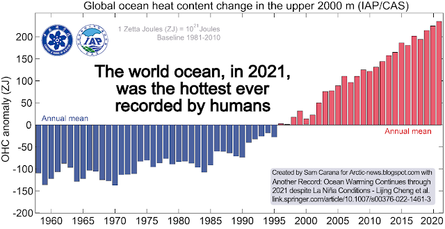
Of the extra heat from Earth's energy imbalance, about 93% ends up in the ocean as increasing ocean heat content (see image below), 3% goes into melting ice, 4% goes into raising temperatures of land and melting permafrost, and less than 1% remains in the atmosphere, as discussed in an earlier post.

[ from earlier post ]

Sea ice has disappeared in the Bering Strait, in part due to warm water from rivers in Alaska, as illustrated by the NOAA image below, which shows sea surface temperatures as high as 18.6°C or 65.48°F.


On July 19, 2022, the sea surface temperature anomaly from 1981-2011 in the Arctic Ocean was as high as 14.0°C or 25.2°F (at green circle), as illustrated by the screenshot below of a nullschool.net image (with text added). In 1981-2011, the sea surface temperature at this spot (at the green circle in the Kara Sea) at this time of year was around freezing point.


The above image also shows a distorted Jet Stream (at 250 hPa) moving over the Arctic ocean, instead of circumventing the Arctic and thus keeping heat out of the Arctic and keeping cold inside the Arctic, as it used to be.  


The above NOAA image illustrates how the Gulf Stream is pushing warm water toward the Arctic, with sea surface temperatures in the North Atlantic reaching as high as 32.6°C or 90.68°F on July 23, 2022.

Latent heat

Latent heat is heat that is (less and less) going into melting the sea ice. The reason this heat is called latent (hidden) heat, is that it doesn't raise the temperature of the water, but instead gets consumed in the process of melting the ice. Latent heat is energy associated with a phase change, such as the energy consumed when solid ice turns into water (i.e. melting). During a phase change, the temperature remains constant. Sea ice acts as a buffer that absorbs heat, while keeping the temperature at zero degrees Celsius. As long as there is sea ice in the water, this sea ice will keep absorbing heat, so the temperature doesn't rise at the sea surface. The amount of energy absorbed by melting ice is as much as it takes to heat an equivalent mass of water from zero to 80°C.


Once most of the sea ice that was hanging underneath the surface is gone, further heat will still keep moving underneath the sea ice from the Atlantic Ocean and - to a lesser extent - from the Pacific Ocean into the Arctic Ocean. Without the latent heat buffer, this heat must go elsewhere, i.e. it will typically raise the temperature of the water. The atmosphere will also warm up faster. More evaporation will occur once the sea ice is gone, further warming up the atmosphere.

A 2019 analysis concludes that the latent heat tipping point gets crossed when the sea surface temperature anomaly on the Northern Hemisphere gets higher than 1°C above 20th century's temperature and when there is little or no thick sea ice left. As the image below indicates, the temperature anomaly of 1°C above the 20th century average looks set to be crossed in the course of the year 2021.
As the Latent Heat Tipping Point gets crossed, there may still be a thin layer of ice at the surface, at least as long as air temperatures are low enough to keep it frozen and as long as strong winds haven't pushed the sea ice out of the Arctic Ocean. This thin layer of ice will still consume some ocean heat below the surface, but at the same time it acts as a seal, preventing heat from the Arctic Ocean to enter the atmosphere. Even if a lot of sea ice remains, the situation is dangerous, if not even more dangerous. The continuing La Niña could cause a lot of thin sea ice to remain at the surface of the Arctic Ocean this year. The more sea ice remains, the less ocean heat can be transferred from the Arctic Ocean to the atmosphere over the Arctic Ocean, which means that more heat remains in the Arctic Ocean.

One huge danger is that, as the buffer disappears that until now has consumed huge amounts of ocean heat, more heat will reach methane hydrates at the seafloor of the Arctic Ocean, causing them to get destabilized and resulting in releases of methane from these hydrates and from free gas underneath that was previously sealed by the hydrates.

As the latent heat buffer of the sea ice underneath the surface disappears, more of this heat could then reach sediments at the seafloor of the Arctic Ocean, threatening eruptions to occur of seafloor methane (from hydrates and from free gas underneath the hydrates). The methane could similarly push up temperatures dramatically over the Arctic, and globally over the next few years.

[ feedback #14: Latent Heat ]

The above 2014 image, from the feedbacks page, shows three of the numerous feedbacks that are accelerating warming in the Arctic. Feedback #1 is the albedo feedback. Feedback #14 refers to the loss of the Latent Heat Buffer and warming of the Arctic Ocean. Feedback #2 refers to methane releases.

Heatwaves look set to continue on the Northern Hemisphere, extending heat over the Arctic Ocean and thus affecting Arctic sea ice from above, while warm water from rivers will cause more melting at the surface, and while rising ocean heat will continue to cause more melting of the ice underneath the surface. If this continues, we can expect a new record low for sea ice in September 2022 and the joint loss of the latent heat buffer and the loss of albedo could push up temperatures dramatically over the Arctic, while the additional methane could similarly push up temperatures dramatically over the Arctic, and globally over the next few years.

[ The Buffer has gone, feedback #14 on the Feedbacks page ]
As discussed at the albedo page and the feedbacks page, albedo change, loss of the latent heat buffer and changes to the Jet Stream are important feedbacks. 


The above image, adapted from an ECMWF.int forecast for July 29, 2022, 12 UTC, run at that time, shows virtually no snow and ice cover over land except Greenland. The image also shows the difference such cover or the lack thereof makes in albedo. 

[ click on images to enlarge ]
The above image, adapted from NOAA Coral Bleaching Heat Stress Monitoring, shows expected coral bleaching heat stress for August to November 2022. The image on the right shows that coral bleaching alert level 2 was reached in the Barents Sea (green circle) on July 29, 2022, while a distorted Jet Stream is pushing warm, salty water from the Atlantic Ocean into the Arctic Ocean. 

2022 study of the Blob, a warm water area in the North Pacific that began in late 2013, concludes that the unusually warm waters were transported northward from further south. The researchers found that abnormally warm temperatures extended 1,000 meters (3,280 feet) below the surface.


The above image shows the Blob on July 24, 2022, with sea surface temperature anomalies as high as 10.5°C or 18.8°F on July 24, 2022. The North Pacific Current is visible, extending eastward from the coast of Japan.

Arctic-news has long (e.g. in this 2017 post) warned that changes to the Jet Stream can strengthen storms that can in turn cause a large amount of warm, salty water to abruptly move north and enter the Arctic Ocean from the Atlantic Ocean and trigger destabilization of methane hydrates at the seafloor of the Arctic Ocean, resulting in eruption of huge amounts of methane that could drive humans into extinction in a matter of years. 


Conclusion

In conclusion, temperatures could rise strongly in the Arctic soon, due to sea ice loss in combination with feedbacks and an upcoming El Niño coinciding with a peak in sunspots, with the potential to drive humans extinct as early as in 2025, while temperatures would continue to skyrocket in 2026, making it in many respects rather futile to speculate about what will happen beyond 2026. At the same time, the right thing to do now is to help avoid the worst things from happening, through comprehensive and effective action as described in the Climate Plan.


Links

• Blue Ocean Event
https://arctic-news.blogspot.com/p/blue-ocean-event.html

• National Snow and Ice Data Center (NSIDC)
https://nsidc.org

• Visualization Service of Horizontal scale Observations at Polar region (Vishop) 
https://ads.nipr.ac.jp/vishop/#/extent

• Naval Research Laboratory
https://www7320.nrlssc.navy.mil/GLBhycomcice1-12/arctic.html

• University of Bremen
https://seaice.uni-bremen.de/databrowser

• NASA Worldview satellite
https://worldview.earthdata.nasa.gov

• NOAA - sea surface temperature

• Human Extinction by 2025? 


Friday, March 18, 2022

Signs of the rise to come

Arctic sea ice extent has fallen strongly over the past few weeks and looks set to keep falling rapidly over the next few months. 


Ocean heat is at record levels, as illustrated by the image below and as discussed in an earlier post


The image below shows the temperature at the North Pole reaching 0.7°C or 33.3°F (at 1000 hPa, at the green circle) on March 16, 2022, with ocean currents depicted at the background.


How could the temperature at the North Pole get this high, in March? 

As said, ocean heat is at record levels. This is heating up the air over the Atlantic Ocean. At times, huge amounts of heat are getting pushed into the Arctic due to a distorted Jet Stream. The image on the right shows the Jet Stream on the Northern Hemisphere on March 16, 2022, with strong winds at 250 hPa pushing heat from the Atlantic Ocean into the Arctic.

Furthermore, the Gulf Stream is pushing huge amounts of ocean heat toward the Arctic. 

The image below shows that sea surface temperatures were as much as 14.1°C or 25.3°F higher than 1981-2011 off the North American coast (green circle) on March 5, 2022.


The image below shows that, on March 16, 2022, the temperature in the Arctic was 3.5°C higher than 1979-2000. 


Below, a Climate Reanalyzer forecast for March 18, 2022, of very high temperature anomalies over Antarctica combined with a forecast of a diversion over Antarctica of the Southern Polar Jet Stream (wind at 250 hPa).


As the combination image below shows, the temperature on Antarctica was 12.5°C or 54.4°F at 1000 hPa at the green circle on March 17, 2022 at 17:00 UTC. The image in the left panel shows high sea surface temperature anomalies south of Australia, while the Jet Stream (250 hPa) moves over Antarctica. The image in the right panel shows wind and temperature at 1000 hPa. 


What causes such distortions of the Jet Stream?

• Emissions by people heat up the air, and heat up oceans and make winds stronger, as discussed in an earlier post.

• Another mechanism affecting the Jet Stream is that, as oceans heat up, the temperature difference between land and oceans widens both in Summer and in Winter and this can cause the Jet Stream to divert deeper from the narrow path it used to follow, as discussed in an earlier post

• What especially affects the Jet Stream on the Northern Hemisphere is that, as the Arctic gets hit hard by temperature rises, the temperature difference narrows between the Arctic and the Equator, slowing the Jet Stream; this can prolong and amplify extreme weather events.


Signs of the things to come

The above events could be seen as signs of the strength and the speed of the rise to come.  


Rise due to La Niña and high sunspots

The image below indicates that the global temperature difference between the top of an El Niño and the bottom of a La Niña period could be more than half a degree Celsius.


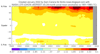
The highest temperature anomalies have over the years shown up at the highest latitudes North, i.e. the Arctic Ocean, in particular during El Niño periods.

This is illustrated by the image on the right, created with a NASA image that shows temperature anomalies of up to 4.1°C (versus 1951-1980) over the Arctic Ocean.

The next image on the right, by Climate Reanalyzer, illustrates that very high temperature anomalies can show up at the highest latitudes North during Winter on the Northern Hemisphere, in this case a temperature anomaly (vs 1979-2000) of 7°C for the Arctic as a whole on February 28, 2022. 

It is ominous for such high anomalies to show up in the Arctic during a La Niña period, and when it's Winter on the Northern Hemisphere when there's only very little sunlight reaching the Arctic. 

For comparison, the next image on the right shows a temperature anomaly (vs 1979-2000) of 7.7°C for the Arctic as a whole on November 18, 2016, when there was an El Niño. 

We're currently in the depth of a persistent La Niña, as illustrated by the next image on the right, adapted from NOAA. This has been suppressing the temperature and it will keep suppressing the temperature until the start of the next El Niño. The next El Niño could push temperatures up even more strongly than the average El Niño, for a number of reasons.

As the temperature keeps rising, ever more frequent strong El Niño events are likely to occur, as discussed in an earlier post. Furthermore, a 2019 study analyzes how tipping the ENSO into a permanent El Niño can trigger state transitions in global terrestrial ecosystems, as mentioned in an earlier post.

Currently, the temperature rise is additionally suppressed by low sunspots. Within a few years time, sunspots can be expected to reach the peak of their current cycle. Observed sunspots look stronger than predicted, as described at the sunspots page. According to IPCC AR4, warming by solar irradiance ranges from 0.06 to 0.3 W/m².


Rise due to further elements

[ from the Extinction page ]
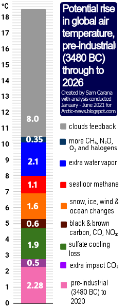
On top of the temperature rise that can be expected to unfold over the next few years due to variables such as an upcoming  El Niño and high sunspots, there is the temperature rise due to further elements.

One of these elements causing the temperature to rise is the falling away of sulfate aerosols, while there could be a further temperature rise due to releases of other aerosols that have a net warming impact, such as black and brown carbon, which can increase dramatically as more wood burning and forest fires take place.

As the temperature of the atmosphere rises, this will trigger self-reinforcing feedbacks such as an increase in water vapor combined with a decrease in lower clouds decks, further increasing the temperature, as described at the clouds feedback page.

What could further push up temperatures a lot over the next few years is the compound impact of feedbacks in the Arctic, including decline of the snow and ice cover, releases of greenhouse gases from degrading subsea and terrestrial permafrost, and further distortion of the Jet Stream causing more extreme weather events.


Conclusion

The situation is dire and calls for the most comprehensive and effective action, as described at the Climate Plan.


Links

• Albedo loss in Antarctica
https://arctic-news.blogspot.com/2022/02/albedo-loss-in-antarctica.html

• NSIDC - Charctic interactive Sea Ice Graph
https://nsidc.org/arcticseaicenews/charctic-interactive-sea-ice-graph

• Nullschool.net
https://earth.nullschool.net

• Climate Reanalyzer
https://climatereanalyzer.org

• Accelerating loss of global snow and ice cover
https://arctic-news.blogspot.com/2022/02/accelerating-loss-of-global-snow-and-ice-cover.html

• Why stronger winds over the North Atlantic are so dangerous

• NOAA - ENSO: Recent Evolution, Current Status and Predictions
https://www.cpc.ncep.noaa.gov/products/analysis_monitoring/lanina/enso_evolution-status-fcsts-web.pdf

• Historical change of El Niño properties sheds light on future changes of extreme El Niño - by Bin Wang et al. 
https://www.pnas.org/content/116/45/22512

• Tipping the ENSO into a permanent El Niño can trigger state transitions in global terrestrial ecosystems - by Mateo Duque-Villegas et al. 
https://esd.copernicus.org/articles/10/631/2019

• Accelerating loss of global snow and ice cover 

• Clouds feedback

• Feedbacks in the Arctic


Wednesday, May 1, 2019

Greenhouse Gas Levels Keep Accelerating

Carbon Dioxide


Weekly CO₂ (carbon dioxide) levels at Mauna Loa, Hawaii, in May, 2019, reached 415.39 ppm, as above image shows. An ominous trendline points at 420 ppm in 2020.


The daily average CO₂ level recorded by NOAA at Mauna Loa, Hawaii, on May 15, 2019, was 415.64 ppm, as above image shows. The image below also shows hourly average levels from April 15, 2019, to May 15, 2019.


Current CO₂ levels far exceed levels that were common during the past 800,000 years, as the image below shows. CO₂ levels moved between roughly 180 and 280 ppm, while the temperature went up and down by some 10°C or 18°F.


The daily average CO₂ level recorded by scripps.ucsd.edu at Mauna Loa, Hawaii, on May 13, 2019, was 415.5 ppm and the May 15, 2019, level was 415.7 ppm. On May 14, 2019, one hourly average exceeded 417 ppm.


The situation is dire

This level of 417 ppm is 139 ppm above the CO₂ level in the year 1750 and more than 157 ppm above what the CO₂ level would have been if levels had followed a natural trend. As shown by the inset (from Ruddiman et al.) in above image, a natural trend points at levels below 260 ppm.

Furthermore, methane levels are rising even faster than CO₂ levels. While CO₂ levels did rise by 146% since 1750, methane levels did rise by 257% since that time and there is much potential for an even faster rise in methane levels due to seafloor hydrate releases. Levels of nitrous oxide also keep rising rapidly.

Such a rise in greenhouse gas levels has historically corresponded with more than 10°C or 18°F of warming, when looking at greenhouse gas levels and temperatures over the past 420,000 years, as illustrated by the image below.


Given that a 100 ppm rise in CO₂ did historically cause temperatures to rise by 10°C or 18°F, how much warming would be in line with a 157 ppm CO₂ and how fast could such a rise unfold?

A temperature of 10°C or 18° above 1750 seems in line with such high greenhouse gas levels. This is illustrated by above graph, based on 420,000 years of ice core data from Vostok, Antarctica, and as the post What Does Abrupt Climate Change Look Like? describes.


Why isn't it much warmer now? Why hasn't such a rise happened yet? Oceans and ice are still holding off such a rise, by absorbing huge amounts of warming. Of 1993-2003 warming, 95.5% was absorbed by oceans and ice. However, ocean stratification and ice loss are making the atmosphere take up more and more heat.

There are further warming elements, in addition to the accelerating rise in greenhouse gas levels. Mentioned above is the loss of the snow and ice cover. The domino effect is a popular way to demonstrate a chain reaction. It is typically sequential and typically uses dominoes that are equal in size. A chain reaction can be achieved with solid dominoes each as much as 1.5 times larger than the previous one. The exponential function is discussed in the video below by Guy McPherson. Rather than following a linear order, warming elements can be self-reinforcing feedback loops and can influence each other in ways that multiply (rather than pass on) their impact, which can speed up the temperature rise exponentially.

So, how fast and by how much could temperatures rise? As oceans and ice are taking up ever less heat, rapid warming of the lower troposphere could occur very soon. When including the joint impact of all warming elements, as described in a recent post, abrupt climate change could result in a rise of as much as 18°C or 32.4°F by 2026. This could cause most life on Earth (including humans) to go extinct within years.

Methane

Next to carbon dioxide, there are further greenhouse gases. Methane is important, because of its high short-term potency as a greenhouse gas and because methane levels in the atmosphere have hugely risen since 1750, and especially recently, as illustrated by the image on the right.

Carbon dioxide (CO₂), methane (CH₄) and nitrous oxide (N₂O) levels in the atmosphere in 2017 were, respectively, 257%, 146% and 122% their 1750 levels.

A recent study by Turetsky et al. concludes that, since sudden collapse releases more carbon per square metre because it disrupts stockpiles deep in frozen layers, and since abrupt thawing releases more methane than gradual thawing does, the impact of thawing permafrost on Earth’s climate could be twice that expected from current models.

As said, there also is a huge and growing danger of large abrupt methane releases from clathrates contained in sediments at the seafloor of the Arctic Ocean.

As illustrated by the image below, methane levels are rising and this rise is accelerating.


The graph shows July 1983 through December 2018 monthly global methane means at sea level, with added trend. Higher methane means can occur at higher altitude than at sea level. On Sep 3, 2018, daily methane means as high as 1905 ppb were recorded at 307 mb, an altitude at which some of the strongest growth in methane has occurred, as discussed in earlier posts such as this one.

The recent rise in methane is the more worrying in the light of recent research that calculates that methane's radiative forcing is about 25% higher than reported in IPCC AR5, implying that methane's GWP (global warming potential) over 10 years may be well over 150 times as much as CO₂.

Nitrous Oxide

Next to carbon dioxide and methane, there are further greenhouse gases, of which nitrous oxide is particularly important. Nitrous oxide is up to 300 times as potent as a greenhouse gas as carbon dioxide and has a lifetime of 121 years. Several recent studies point at the danger of huge releases of nitrous oxide from permafrost.

According to a 2017 study by Voigt et al., Arctic permafrost contains vast amounts of nitrogen (more than 67 billion tons). Warming of the Arctic permafrost is accelerating, causing rapid thaw of permafrost soils, and this now threatens to cause huge releases of nitrous oxide to the atmosphere. The study concluded that nitrous oxide emissions in the Arctic are likely substantial and underestimated, and show high potential to increase with permafrost thaw.

In the video below, Paul Beckwith discusses nitrous oxide.


In the video below, Paul Beckwith discusses the recent study by Wilkerson et al.


The study by Wilkerson et al. shows that nitrous oxide emissions from thawing Alaskan permafrost are about twelve times higher than previously assumed. A 2018 study by Yang et al. points at the danger of large nitrous oxide releases from thawing permafrost in Tibet. Even more nitrous oxide could be released from Antarctica. The danger is illustrated by the image below, which shows that massive amounts of nitrous oxide were recorded over Antarctica on April 29, 2019.


Depletion of the Ozone Layer

In addition to being a potent greenhouse gas, nitrous oxide is also an ozone depleting substance (ODS). As the left panel of the image below shows, growth in the levels of chlorofluorocarbons (CFCs) has slowed over the years, yet their impact will continue for a long time, given their long atmospheric lifetime (55 years for CFC-11 and 140 years for CFC-12). Since nitrous oxide levels continue to increase in the atmosphere, while the impact of CFC-11 and CFC-12 is slowly decreasing over time, the impact (as an ODS) of nitrous oxide has relatively grown, as the right panel of the image below shows.

[ from an earlier post ]
James Anderson, co-recipient of the 1995 Nobel Prize in chemistry for his work on ozone depletion, said in 2018 that "we have five years to save ourselves from climate change".

Comprehensive Action

In conclusion, while it's important to reduce emissions of all greenhouse gases, reducing emissions of methane and nitrous oxide is particularly important. To both reduce polluting emissions and to remove greenhouse gases from the atmosphere and oceans, the Climate Plan recommends feebates as depicted in the image below. As the image also mentions, further lines of action will be needed to avoid a rapid rise in temperature.

[ from an earlier post ]
Meanwhile, Arctic sea ice reached a new record low for April, as illustrated by the NSIDC image below.

In the video below, Guy McPherson describes what threatens to eventuate soon. This is an edit of the April 22, 2019, video in which Guy McPherson was interviewed by Peter B. Collins for the community television station in Marin County, California.


In the video below, Guy McPherson gives a presentation at the Center for Spiritual Living, in Chico, April 28, 2019.


The situation is dire and calls for comprehensive and effective action as described in the Climate Plan.


Links

• Climate Plan
https://arctic-news.blogspot.com/p/climateplan.html

• Permafrost collapse is accelerating carbon release, by Merritt Turetsky et al. (30 April 2019)
https://www.nature.com/articles/d41586-019-01313-4

• Permafrost nitrous oxide emissions observed on a landscape scale using the airborne eddy-covariance method, by Jordan Wilkerson et al. (April 3, 2019)
https://www.atmos-chem-phys.net/19/4257/2019/

• Can natural or anthropogenic explanations of late-Holocene CO2 and CH4 increases be falsified?, by William Ruddiman et al. (2011)
https://journals.sagepub.com/doi/10.1177/0959683610387172

• Radiative forcing of carbon dioxide, methane, and nitrous oxide: A significant revision of the methane radiative forcing, by Etminan et al. (2016)
https://agupubs.onlinelibrary.wiley.com/doi/full/10.1002/2016GL071930

• Magnitude and Pathways of Increased Nitrous Oxide Emissions from Uplands Following Permafrost Thaw, by Guibiao Yang et al. (July 9, 2018)
https://pubs.acs.org/doi/10.1021/acs.est.8b02271

• Increased nitrous oxide emissions from Arctic peatlands after permafrost thaw, by Carolina Voigt et al.
https://www.pnas.org/content/early/2017/05/23/1702902114

• We Have Five Years To Save Ourselves From Climate Change, Harvard Scientist Says - James Anderson (January 15, 2018)
https://www.forbes.com/sites/jeffmcmahon/2018/01/15/carbon-pollution-has-shoved-the-climate-backward-at-least-12-million-years-harvard-scientist-says/

• A rise of 18°C or 32.4°F by 2026?
https://arctic-news.blogspot.com/2019/02/a-rise-of-18c-or-324f-by-2026.html

• Care for the Ozone Layer
https://arctic-news.blogspot.com/2019/01/care-for-the-ozone-layer.html

• What Does Runaway Warming Look Like?
https://arctic-news.blogspot.com/2018/10/what-does-runaway-warming-look-like.html

• Rapid ice loss in early April leads to new record low - NSIDC
https://nsidc.org/arcticseaicenews/2019/05/rapid-ice-loss-in-early-april-leads-to-new-record-low/