Saturday, February 2, 2019

Global Warming is destroying our Liveable Climate

Global Warming is destroying our Liveable Climate. To illustrate what's going on, have a look at the images below, showing low temperatures in Africa at 32°N latitude and high temperatures near Svalbard at about 78°N latitude.

2018 image
2019 image

Surface air temperatures near Svalbard were as high as 5.2°C or 41.4°F near Svalbard on February 3, 2019. At the same time, it was as cold as -3.5°C or 25.6°F in Africa.

The contrast was even more profound on February 4, 2018, when at those same spots it was as cold as -10°C or 13.9°F in Africa, while at the same time it was as warm as 5.8 or 42.4°F near Svalbard.

How is this possible?

As the Arctic warms up faster than the rest of the world, the temperature difference between the North Pole and the Equator narrows, making the jet stream wavier, thus enabling cold air from the Arctic to descend further south, as illustrated by the image on the right, showing instantaneous wind power density at 250 hPa (jet stream) on February 4, 2018.
[ NOAA Climate.gov cartoon by Emily Greenhalgh ]

Furthermore, as oceans get warmer, the temperature difference between land and oceans increases in Winter. This larger temperature difference results in stronger winds that can carry more warm, moist air inland, e.g. into the U.S., as illustrated by the cartoon on the right.

As the jet stream becomes wavier, this also enables more heat to enter the Arctic.

On December 8, 2018, the sea surface temperature near Svalbard was 18.2°C or 32.7°F warmer than 1981-2011. On January 23, 2019, sea surface temperatures at that spot were as high as 18.3°C or 64.9°F, as illustrated by the image on the right, from an earlier post.

A warmer sea surface can cause winds to grow dramatically stronger, and they can push warm, moist air into the Arctic, while they can also speed up sea currents that carry warm, salty water into the Arctic Ocean.

As warmer water keeps flowing into the Arctic Ocean and as air temperatures in the Arctic are now starting to rise on the back of a strengthening El Niño, fears for a Blue Ocean Event are rising.

Rivers can also carry huge amounts of warm water from North America and Siberia into the Arctic Ocean, as these areas are getting hit by ever stronger heatwaves that are hitting the Arctic earlier in the year.

With Arctic sea ice at a low, it won't be able to act as a buffer to absorb heat for long, with the danger that an influx of warm, salty water will reach the seafloor and trigger methane eruptions.

Ominously, the image below shows peak methane levels as high as 2764 ppb on February 2, 2019.


The situation is dire and calls for comprehensive and effective action, as described in the Climate Plan.

See also Dave Borlace's video below:


Links

• How frigid polar vortex blasts are connected to global warming, by Jennifer Francis
https://arctic-news.blogspot.com/2019/02/how-frigid-polar-vortex-blasts-are-connected-to-global-warming.html

• Are record snowstorms proof that global warming isn’t happening?
https://www.climate.gov/news-features/climate-qa/are-record-snowstorms-proof-global-warming-isn%E2%80%99t-happening

• Accelerating growth of carbon dioxide in the atmosphere
https://arctic-news.blogspot.com/2019/01/accelerating-growth-of-carbon-dioxide-in-the-atmosphere.html

• Dangerous situation in Arctic
https://arctic-news.blogspot.com/2018/11/dangerous-situation-in-arctic.html

• Blue Ocean Event
https://arctic-news.blogspot.com/2018/09/blue-ocean-event.html

• Climate Plan
https://arctic-news.blogspot.com/p/climateplan.html

• Extinction
https://arctic-news.blogspot.com/p/extinction.html


Friday, February 1, 2019

How frigid polar vortex blasts are connected to global warming

by Jennifer Francis, Rutgers University

File 20190128 39344 1rjndrb.jpg?ixlib=rb 1.1
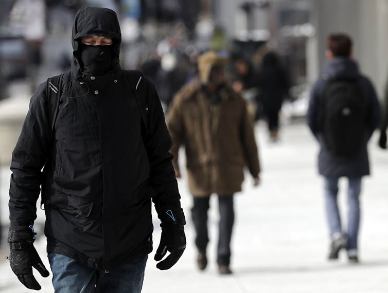
Bundled up against the cold in downtown Chicago, Sunday, Jan. 27, 2019.
AP Photo/Nam Y. Huh

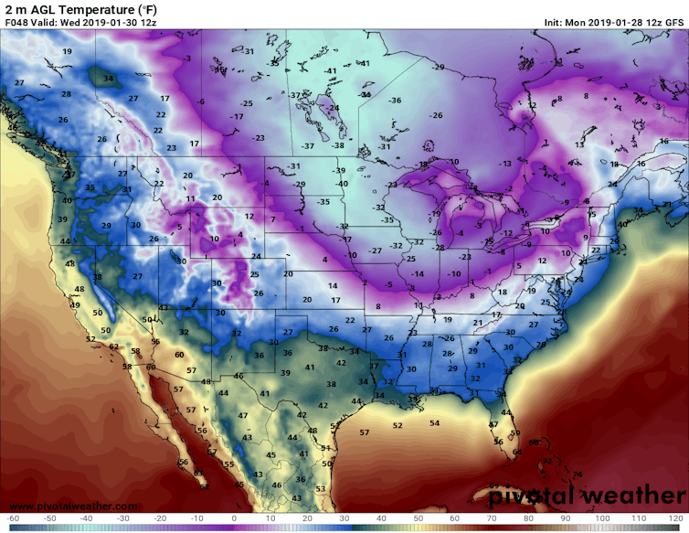
A record-breaking cold wave is sending literal shivers down the spines of millions of Americans. Temperatures across the upper Midwest are forecast to fall an astonishing 50 degrees Fahrenheit (28 degrees Celsius) below normal this week – as low as 35 degrees below zero. Pile a gusty wind on top, and the air will feel like -60 F.


Predicted near-surface air temperatures (F) for Wednesday morning, Jan. 30, 2019. Forecast by NOAA’s Global Forecast System model. Pivotal Weather, CC BY-ND
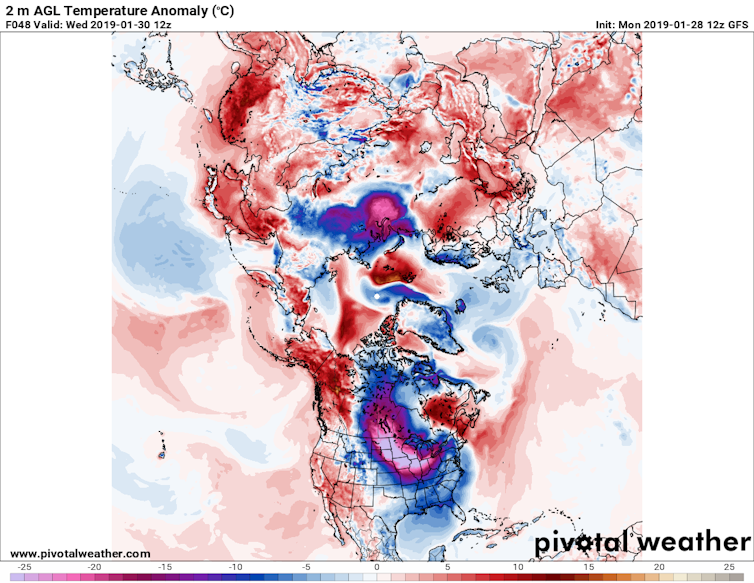
This cold is nothing to sneeze at. The National Weather Service is warning of brutal, life-threatening conditions. Frostbite will strike fast on any exposed skin. At the same time, the North Pole is facing a heat wave with temperatures approaching the freezing point – about 25 degrees Fahrenheit (14 C) above normal.


Predicted near-surface air temperature differences (C) from normal, relative to 1981-2010.
Pivotal Weather, CC BY-ND
What is causing this topsy-turvy pattern? You guessed it: the polar vortex.

In the past several years, thanks to previous cold waves, the polar vortex has become entrenched in our everyday vocabulary and served as a butt of jokes for late-night TV hosts and politicians. But what is it really? Is it escaping from its usual Arctic haunts more often? And a question that looms large in my work: How does global warming fit into the story?


Jimmy Fallon examines the pros and cons of the polar vortex.

Rivers of air

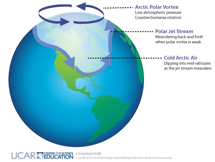
Actually, there are two polar vortices in the Northern Hemisphere, stacked on top of each other. The lower one is usually and more accurately called the jet stream. It’s a meandering river of strong westerly winds around the Northern Hemisphere, about seven miles above Earth’s surface, near the height where jets fly.

The jet stream exists all year, and is responsible for creating and steering the high- and low-pressure systems that bring us our day-to-day weather: storms and blue skies, warm and cold spells. Way above the jet stream, around 30 miles above the Earth, is the stratospheric polar vortex. This river of wind also rings the North Pole, but only forms during winter, and is usually fairly circular.


Dark arrows indicate rotation of the polar vortex in the Arctic; light arrows indicate the location of the polar jet stream when meanders form and cold, Arctic air dips down to mid-latitudes. L.S. Gardiner/UCAR, CC BY-ND
Both of these wind features exist because of the large temperature difference between the cold Arctic and warmer areas farther south, known as the mid-latitudes. Uneven heating creates pressure differences, and air flows from high-pressure to low-pressure areas, creating winds. The spinning Earth then turns winds to the right in the northern hemisphere, creating these belts of westerlies.

Why cold air plunges south

Greenhouse gas emissions from human activities have warmed the globe by about 1.8 degrees Fahrenheit (1 C) over the past 50 years. However, the Arctic has warmed more than twice as much. Amplified Arctic warming is due mainly to dramatic melting of ice and snow in recent decades, which exposes darker ocean and land surfaces that absorb a lot more of the sun’s heat.

Because of rapid Arctic warming, the north/south temperature difference has diminished. This reduces pressure differences between the Arctic and mid-latitudes, weakening jet stream winds. And just as slow-moving rivers typically take a winding route, a slower-flowing jet stream tends to meander.

Large north/south undulations in the jet stream generate wave energy in the atmosphere. If they are wavy and persistent enough, the energy can travel upward and disrupt the stratospheric polar vortex. Sometimes this upper vortex becomes so distorted that it splits into two or more swirling eddies.

These “daughter” vortices tend to wander southward, bringing their very cold air with them and leaving behind a warmer-than-normal Arctic. One of these eddies will sit over North America this week, delivering bone-chilling temperatures to much of the nation.

Deep freezes in a warming world

Splits in the stratospheric polar vortex do happen naturally, but should we expect to see them more often thanks to climate change and rapid Arctic warming? It is possible that these cold intrusions could become a more regular winter story. This is a hot research topic and is by no means settled, but a handful of studies offer compelling evidence that the stratospheric polar vortex is changing, and that this trend can explain bouts of unusually cold winter weather.

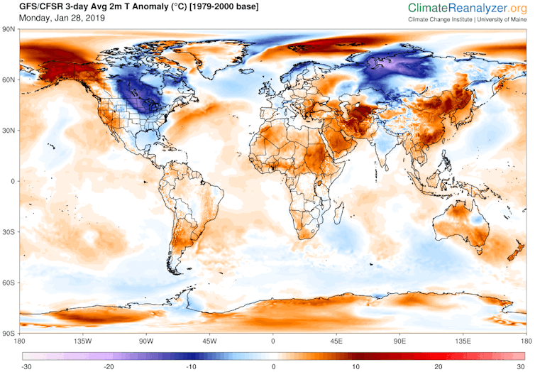
Undoubtedly this new polar vortex attack will unleash fresh claims that global warming is a hoax. But this ridiculous notion can be quickly dispelled with a look at predicted temperature departures around the globe for early this week. The lobe of cold air over North America is far outweighed by areas elsewhere in the United States and worldwide that are warmer than normal.


Predicted daily mean, near-surface temperature (C) differences from normal (relative to 1979-2000) for Jan. 28-30, 2019. Data from NOAA’s Global Forecast System model.
Climate Reanalyzer, Climate Change Institute, University of Maine., CC BY-ND
Symptoms of a changing climate are not always obvious or easy to understand, but their causes and future behaviors are increasingly coming into focus. And it’s clear that at times, coping with global warming means arming ourselves with extra scarfs, mittens and long underwear.

Jennifer Francis, Visiting Professor, Rutgers University

This article is republished from The Conversation under a Creative Commons license. Read the original article.


Wednesday, January 30, 2019

A Revision of Future Climate Change Trends

By Andrew Glikson

Abstract


As the Earth continues to heat, paleoclimate evidence suggests transient reversals will result in accentuating the temperature polarities, leading to increase in the intensity and frequency of extreme weather events.

Pleistocene paleoclimate records indicate interglacial temperature peaks are consistently succeeded by transient stadial freeze events, such as the Younger Dryas and the 8.5 kyr-old Laurentide ice melt, attributed to cold ice melt water flow from the polar ice sheets into the North Atlantic Ocean. The paleoclimate evidence raises questions regarding the mostly linear to curved future climate model trajectories proposed for the 21ᵗʰ century and beyond, not marked by tipping points. However, early stages of a stadial event are manifest by a weakening of the North Atlantic overturning circulation and the build-up of a large pool of cold water south and east of Greenland and along the fringes of Western Antarctica. Comparisons with climates of the early Holocene Warm Period and the Eemian interglacial when global temperatures were about +1°C higher than late Holocene levels. The probability of a future stadial event bears major implications for modern and future climate change trends, including transient cooling of continental regions fringing the Atlantic Ocean, an increase in temperature polarities between polar and tropical zones across the globe, and thereby an increase in storminess, which need to be taken into account in planning global warming adaptation efforts.

Introduction

Reports of the International Panel of Climate Change (IPCC)⁽¹⁾, based on thousands of peer reviewed science papers and reports, offer a confident documentation of past and present processes in the atmosphere⁽²⁾, including future model projections (Figure 1). When it comes to estimates of future ice melt and sea level change rates, however, these models contain a number of significant departures from observations based on the paleoclimate evidence, from current observations and from likely future projections. This includes departures in terms of climate change feedbacks from land and water, ice melt rates, temperature trajectories, sea level rise rates, methane release rates, the role of fires, and observed onset of transient stadial (freeze) events⁽³⁾. Early stages of stadial event/s are manifest by the build-up of a large pool of cold water in the North Atlantic Ocean south of Greenland and along the fringes of the Antarctic continent (Figure 2).
Figure 1. IPCC AR5: Time series of global annual mean surface air temperature anomalies relative to 1986–2005
from CMIP5 (Coupled Model Inter-comparison Project) concentration-driven experiments.
Projections are shown for each RCP for the multi model mean (solid lines) and the 5–95%
range (±1.64 standard deviation) across the distribution of individual models (shading).⁽⁴⁾
Hansen et al. (2016) (Figure 2) used paleoclimate data and modern observations to estimate the effects of ice melt water from Greenland and Antarctica, showing cold low-density meltwater tend to cap increasingly warm subsurface ocean water, affecting an increase ice shelf melting, accelerating ice sheet mass loss (Figure 3) and slowing of deep water formation (Figure 4). Ice mass loss would raise sea level by several meters in an exponential rather than linear response, with doubling time of ice loss of 10, 20 or 40 years yielding multi-meter sea level rise in about 50, 100 or 200 years.

Linear to curved temperature trends portrayed by the IPCC to the year 2300 (Figure 1) are rare in the Pleistocene paleo-climate record, which abrupt include warming and cooling variations during both glacial (Dansgaard-Oeschger cycles; Ganopolski and Rahmstorf 2001⁽⁵⁾; Camille and Born, 2019⁽⁶⁾) and interglacial (Cortese et al. 2007⁽⁷⁾) periods. Hansen et al.’s (2016) model includes sharp drops in temperature, reflecting stadial freezing events in the Atlantic Ocean and the sub-Antarctic Ocean and their surrounds, reaching -2°C over several decades (Figure 5).
Figure 2. 2055-2060 surface-air temperature to +1.19°C above 1880-1920
(AIB model modified forcing, ice melt to 1 meter) From: Hansen et al. (2016)⁽⁸⁾
Figure 3. Greenland and Antarctic ice mass change. GRACE data are extension of Velicogna et al. (2014)⁽⁹⁾
gravity data. MBM (mass budget method) data are from Rignot et al. (2011)⁽¹⁰⁾. Red curves are gravity
data for Greenland and Antarctica only; small Arctic ice caps and ice shelf melt add to freshwater input.⁽¹¹⁾
Figure 4. (a) AMOC (Sverdrup⁽¹²⁾) at 28°N in simulations (i.e., including freshwater injection of 720 Gt year−1 in 2011
                around Antarctica, increasing with a 10-year doubling time, and half that amount around Greenland).
(b) SST (°C) in the North Atlantic region (44–60°N, 10–50°W).
Temperature and sea level rise relations during the Eemian interglacial⁽¹³⁾ about 115-130 kyr ago, when temperatures were about +1°C or higher than during the late stage of the Holocene, and sea levels were +6 to +9 m higher than at present, offer an analogy for present developments. During the Eemian overall cooling of the North Atlantic Ocean and parts of the West Antarctic fringe ocean due to ice melt led to increased temperature polarities and to storminess⁽¹⁴⁾, underpinning the danger of global temperature rise to +1.5°C. Accelerating ice melt and nonlinear sea level rise would reach several meters over a timescale of 50–150 years (Hansen et al. 2016)

Figure 5. Global surface-air temperature to the year 2300 in the North Atlantic and Southern Oceans,
including stadial freeze events as a function of Greenland and Antarctic ice melt doubling time

Portents of collapse of the Atlantic Meridional Ocean Circulation (AMOC)


The development of large cold water pools south and east of Greenland (Rahmstorf et al. 2015⁽¹⁵⁾) and at the fringe of West Antarctica (Figures 1 and 5) signify early stages in the development of a stadial, consistent with the decline in the Atlantic Meridional Ocean Circulation (AMOC) (Figure 4). These projections differ markedly from linear model trends (Figure 1). IPCC models mainly assume long term ice melt⁽¹⁶⁾, stating “For the 21st century, we expect that surface mass balance changes will dominate the volume response of both ice sheets (Greenland and Antarctica). A key question is whether ice-dynamical mechanisms could operate which would enhance ice discharge sufficiently to have an appreciable additional effect on sea level rise”⁽¹⁷⁾. The IPCC conclusion is difficult to reconcile with studies by Rignot et al. (2011) reporting that in 2006 the Greenland and Antarctic ice sheets experienced a “combined mass loss of 475 ± 158 Gt/yr, equivalent to 1.3 ± 0.4 mm/yr sea level rise”⁽¹⁸⁾. For the Antarctic ice sheet the IEMB team (2017) states the sheet lost 2,720 ± 1,390 billion tonnes of ice between 1992 and 2017, which corresponds to an increase in mean sea level of 7.6 ± 3.9 millimeter⁽¹⁹⁾.

A non-linear climate warming trend, including stadial freeze events, bears significant implications for planning future adaptation efforts, including preparations for transient deep freeze events in parts of Western Europe and eastern North America, for periods lasting several decades (Figure 5) and coastal defenses against enhanced storminess arising from increased temperature contrasts between the cooled regions and warm tropical latitudes.

Imminent climate risks

Climate model projections for the 21ᵗʰ to 23ʳᵈ centuries need to take paleoclimate evidence more fully into account, including the transient stadial effects of ice melt water flow into the oceans and amplifying feedbacks of global warming from land and oceans. Radiative forcing⁽²⁰], increasing with concentration of atmospheric greenhouse gases and rising by about 0.04 Watt/m²/year over the last 50 years⁽²¹⁾, totaled by more than 2 Watt/m², equivalent to ~3.0°C (~1.5°C per W/m²)⁽²²⁾. The rise of mean global temperatures to date by 0.9°C since 1880⁽²³⁾ therefore represents lag effect, pointing to potential temperature rise by approximately two degrees Celsius. A further rise in global temperatures would be enhanced by amplifying feedbacks from land and oceans, including exposure of water surfaces following sea ice melting, reduction of CO₂ concentration in water, release of methane and fires. Climate change trajectories would be highly irregular as a result of stadial events affected by flow of ice melt water into the oceans. Whereas similar temperature fluctuations and stadial events occurred during past interglacial periods (Cortese et al. 2007⁽²⁴⁾; Figure 6), when temperature fluctuations were close to ~1°C, further rises in temperature in future would enhance the intensity and frequency of extreme weather events, entering uncharted territory unlike any recorded during the Pleistocene, rendering large parts of the continents uninhabitable.

Figure 6. (A) Evolution of sea surface temperatures in 5 glacial-interglacial transitions recorded in ODP 1089
at the sub-Antarctic Atlantic Ocean. Lower grey lines – δ¹⁸O measured on Cibicidoides plankton;
Black lines – sea surface temperature. Marine isotope stage numbers are indicated on top of diagrams.
Note the stadial temperature drop events following interglacial peak temperatures, analogous
to the Younger Dryas preceding the onset of the Holocene (Cortese et al. 2007⁽²⁵⁾).
(B) Mean temperatures for the late Pleistocene and early Holocene.

Note to readers: please click the share buttons above. Forward this article to your email lists. 
Crosspost on your blog site, internet forums. etc.

Andrew Glikson
by Andrew Glikson
Earth and Paleo-climate science, Australia National University (ANU) School of Anthropology and Archaeology,
ANU Planetary Science Institute,
ANU Climate Change Institute,
Honorary Associate Professor, Geothermal Energy Centre of Excellence, University of Queensland.

Books:
http://www.springer.com/gp/book/9783319079073
http://www.springer.com/gp/book/9789400763272
http://www.springer.com/us/book/9783319745442
http://www.springer.com/gp/book/9783319225111
http://www.springer.com/gp/book/9783319572369
http://www.springer.com/gp/book/9789400773318


Notes

(1) IPCC, Special Report, Global Warming of 1.5 ºC
https://www.ipcc.ch
https://www.ipcc.ch/sr15/

(2) Climate Council, Report, The good, the bad and the ugly: limiting temperature rise to 1.5°C
https://www.climatecouncil.org.au/resources/limiting-temperature-rise/

(3) Ice melt, sea level rise and superstorms: evidence from paleoclimate data, climate modeling, and modern observations that 2 °C global warming could be dangerous, by James Hansen et al.
https://www.atmos-chem-phys.net/16/3761/2016/

(4) IPCC Climate Change 2013: Technical Summary, p.89
http://www.climatechange2013.org/images/figures/WGI_AR5_Fig12-5.jpg
http://www.climatechange2013.org/images/report/WG1AR5_TS_FINAL.pdf

(5) Rapid changes of glacial climate simulated in a coupled climate model, by Andrey Ganopolski and Stefan Rahmstorf
https://www.nature.com/articles/35051500
https://www.ncbi.nlm.nih.gov/pubmed/11196631

(6) Coupled atmosphere-ice-ocean dynamics in Dansgaard-Oeschger events, by Camille Li and Andreas Born
https://www.sciencedirect.com/science/article/pii/S0277379118305705

(7) The last five glacial‐interglacial transitions: A high‐resolution 450,000‐year record from the subantarctic Atlantic, by G. Cortese, A. Abelmann and R. Gersonde
https://agupubs.onlinelibrary.wiley.com/doi/full/10.1029/2007PA001457

(8) Ice melt, sea level rise and superstorms: evidence from paleoclimate data, climate modeling, and modern observations that 2 °C global warming could be dangerous, by James Hansen et al. (2016)
https://www.atmos-chem-phys.net/16/3761/2016/acp-16-3761-2016-avatar-web.png
https://www.atmos-chem-phys.net/16/3761/2016/

(9) Regional acceleration in ice mass loss from Greenland and Antarctica using GRACE time‐variable gravity data, by I. Velicogna et al.
https://agupubs.onlinelibrary.wiley.com/doi/10.1002/2014GL061052

(10) Acceleration of the contribution of the Greenland and Antarctic ice sheets to sea level rise, by E. Rignot et al. (2011)
https://agupubs.onlinelibrary.wiley.com/doi/10.1029/2011GL046583

(11) Ice melt, sea level rise and superstorms: evidence from paleoclimate data, climate modeling, and modern observations that 2 °C global warming could be dangerous, by James Hansen et al.
https://www.atmos-chem-phys.net/16/3761/2016/acp-16-3761-2016.pdf

(12) Sverdrup: Unit of flow – 1 Sv is equal to 1,000,000 m³ per second
https://en.wikipedia.org/wiki/Sverdrup

(13) Eemian Interglacial Stage
https://www.britannica.com/science/Eemian-Interglacial-Stage

(14) Giant boulders and Last Interglacial storm intensity in the North Atlantic, by Alessio Rovere et al. (2017)
http://moraymo.us/wp-content/uploads/2018/03/Rovereetal_PNAS_2017.pdf
Northern hemisphere winter storm tracks of the Eemian interglacial and the last glacial inception, by F. Kaspar (2006)
https://www.clim-past.net/3/181/2007/cp-3-181-2007.pdf

(15) Exceptional twentieth-century slowdown in Atlantic Ocean overturning circulation, by Stefan Rahmstorf et al. (2015)
https://www.nature.com/articles/nclimate2554

(16) The UN's Devastating Climate Change Report Was Too Optimistic, by Nafeez Ahmed (Oct 16, 2018)
https://motherboard.vice.com/en_us/article/43e8yp/the-uns-devastating-climate-change-report-was-too-optimistic

(17) IPCC Third Assessment Report, Working Group I: The Scientific Basis
https://archive.ipcc.ch/ipccreports/tar/wg1/416.htm

(18) Acceleration of the contribution of the Greenland and Antarctic ice sheets to sea level rise, by E. Rignot et al. (2011)
https://agupubs.onlinelibrary.wiley.com/doi/full/10.1029/2011GL046583

(19) Mass balance of the Antarctic Ice Sheet from 1992 to 2017
https://www.nature.com/articles/s41586-018-0179-y.epdf

(20) Radiative forcing – the difference between incoming radiation and radiation reflected back to space
https://en.wikipedia.org/wiki/Radiative_forcing

(21) Climate Change in a Nutshell: The Gathering Storm, by James Hansen (18 December 2018)
http://www.columbia.edu/~jeh1/mailings/2018/20181206_Nutshell.pdf

(22) Target atmospheric CO2: Where should humanity aim?, by James Hansen (2008)
https://arxiv.org/abs/0804.1126

(23) NASA: Global temperature
https://climate.nasa.gov/vital-signs/global-temperature/

(24) The last five glacial‐interglacial transitions: A high‐resolution 450,000‐year record from the subantarctic Atlantic, by G. Cortese, A. Abelmann and R. Gersonde
https://agupubs.onlinelibrary.wiley.com/doi/full/10.1029/2007PA001457

(25) The last five glacial‐interglacial transitions: A high‐resolution 450,000‐year record from the subantarctic Atlantic, by G. Cortese, A. Abelmann and R. Gersonde
https://agupubs.onlinelibrary.wiley.com/doi/full/10.1029/2007PA001457

This is an edited version of an article at Global Research
Copyright © Dr. Andrew Glikson, 2019

Friday, January 25, 2019

Accelerating growth of carbon dioxide in the atmosphere

People may not have thought that growth in carbon dioxide (CO₂) levels in the atmosphere would accelerate, when pledges were made in 2015 at the Paris Agreement to take efforts to keep the temperature rise under 1.5°C compared to preindustrial.


Yet, on January 21, 2019, hourly average CO₂ levels well above 414 ppm were recorded at Mauna Loa, Hawaii, the highest levels since such measurements started. A daily average level of 413.86 ppm was recorded on January 22, 2019.


A recent Met Office forecast expects monthly averages to reach a level of 414.7 ppm in May 2019. The forecast expects annual average CO₂ levels at Mauna Loa to be 2.75 ppm higher in 2019 than in 2018. That figure is virtually on the trendline depicted below.


The trend in above image is calculated with NOAA 1959-2017 growth data, with an estimate for 2018 calculated by Sam Carana with NOAA January 2017-November 2018 data (orange dot), and with this Met Office forecast used for 2019 (purple dot).

Strong CO₂ growth is forecast for 2019, due to a number of factors including rising emissions, the added impact of El Niño and less uptake of carbon dioxide by ecosystems. A recent study warns that global warming will enhance both the amplitude and the frequency of eastern Pacific El Niño events and associated extreme weather events. Another recent study warns that, while the terrestrial biosphere now absorbs some 25% of CO₂ emissions by people, the rate of land carbon uptake is likely to fall with reduced soil moisture levels in a warmer world. Furthermore, forest fires will increase as temperatures rise, as soils get more dry and as winds increase in strength, resulting in further increases of CO₂ emissions.

The warming impact of CO₂ can be expected to increase over the next ten years, the more so since the warming impact of CO₂ reaches a peak ten years after emission. In conclusion, CO₂ can cause a global temperature rise of 0.5°C over the next ten years.

Ocean Heat

La Niña has kept much heat in oceans in 2018. Not surprisingly, 2018 was the hottest year for our oceans since global records began in 1958.

As an indication how much heat is contained in the North Atlantic, very high sea surface temperatures did show up recently off the coast of North America, with anomalies on January 23, 2019, as high as 12.6°C or 22.6°F (compared to 1981-2011, green circle on the image on the right).

That day, sea surface temperatures near Svalbard were as high as 18.3°C or 64.9° (green circle, image right). The Gulf Stream carries ocean heat to the Arctic Ocean and it can take a couple of months for this heat to reach the Arctic Ocean and contribute to melting of the sea ice.

So, Arctic sea ice is expected to be invaded by ocean heat from below in 2019, while El Niño will cause high temperatures over the Arctic, melting the sea ice from above.

Furthermore, rivers that end in North America and Siberia can be expected to carry much warm water into the Arctic Ocean.

The image below shows surface air temperature forecasts for February 1, 2019, 15:00 UTC. Low temperatures show up many place on the Northern Hemisphere, such as -44.5°C or -48.2°F in Siberia, -44°C or -47.1°F in Greenland and -40.8°C or -41.4°F near Hudson Bay.


[ NOAA Climate.gov cartoon by Emily Greenhalgh ]
These low temperatures are the result of global warming. As the Arctic warms up faster than the rest of the world, the temperature difference between the North Pole and the Equator narrows, making the jet stream wavier, thus enabling cold air from the Arctic to descend further south.

As the jet stream gets wavier, more warm air can also enter the Arctic from the south. Above image also shows that surface air temperatures near Svalbard are forecast as high as 5.2°C or 41.4°F, illustrating how warm the air can be close to the North Pole, at a time of year when virtually no sunlight reaches that area.

Furthermore, as oceans get warmer, the temperature difference between land and oceans increases in Winter. This larger temperature difference results in stronger winds that can carry more warm and moist air inland, e.g. into the U.S., as illustrated by the cartoon. Stronger winds can also carry more warm and moist air into the Arctic and can speed up the flow of sea currents, causing warm and salty water to reach the sea ice and speed up its decline.

The sea surface is warming up strongly in this area near Svalbard, as the water underneath the surface of the North Atlantic can be much warmer than the water at the surface, and warm water is coming to the surface in line with a rise in the seafloor in this area, as discussed in earlier posts such as this one and this one.

Methane hydrates

With sea ice at a low, it won't be able to act as a buffer to absorb heat for long. One danger is that, as more heat arrives in the Arctic and as the sea ice melts away, the sea ice will no longer be able to act as a buffer absorbing ocean heat any longer, and ocean heat will instead reach sediments at the seafloor of the Arctic Ocean.

[ The Buffer has gone, feedback #14 on the Feedbacks page ]
Joint impact

[ For details, see the Extinction page ]
The joint impact of all this is terrifying. Ocean heat that reaches sediments at the seafloor of the Arctic Ocean can destabilize hydrates, resulting in eruptions of huge amounts of methane. This alone can cause a global temperature rise of 1.1°C in a matter of years.

A lot of this has not been accounted for by the IPCC, i.e. the recent increases in CO₂ emissions, increases in methane releases, increases in further emissions such as nitrous oxide and black carbon, albedo changes due to decline in the snow and ice cover and associated changes such as jet stream changes, more permafrost melting and stronger impacts of future El Niño events.

The image on the right shows the joint impact of the warming elements that threaten to eventuate over the next few years and that could result in a rapid 10°C or 18°F global temperature rise by 2026 or even earlier. Keep in mind that global biodiversity will have collapsed once temperatures have risen by 5°C.

The situation is dire and calls for comprehensive and effective action, as described at the Climate Plan.


Links

• Faster CO₂ rise expected in 2019
https://www.metoffice.gov.uk/news/releases/2019/2019-carbondioxide-forecast

• Increased variability of eastern Pacific El Niño under greenhouse warming, by Wenju Cai et al.
https://www.nature.com/articles/s41586-018-0776-9

• El Niño events will intensify under global warming, by Yoo-Geun Ham
https://www.nature.com/articles/d41586-018-07638-w

• Large influence of soil moisture on long-term terrestrial carbon uptake, by Julia Green et al.
https://www.nature.com/articles/s41586-018-0848-x

• 2018 Continues Record Global Ocean Warming, by Lijing Cheng et al.
https://link.springer.com/article/10.1007/s00376-019-8276-x

• Are record snowstorms proof that global warming isn’t happening?
https://www.climate.gov/news-features/climate-qa/are-record-snowstorms-proof-global-warming-isn%E2%80%99t-happening

• Co-extinctions annihilate planetary life during extreme environmental change, by Giovanni Strona and Corey Bradshaw
https://www.nature.com/articles/s41598-018-35068-1

• Dangerous situation in Arctic
https://arctic-news.blogspot.com/2018/11/dangerous-situation-in-arctic.html

• Accelerating Warming of the Arctic Ocean
https://arctic-news.blogspot.com/2016/12/accelerating-warming-of-the-arctic-ocean.html

• Climate Plan
https://arctic-news.blogspot.com/p/climateplan.html

• Extinction
https://arctic-news.blogspot.com/p/extinction.html