
AP Photo/Nam Y. Huh
A record-breaking cold wave is sending literal shivers down the spines of millions of Americans. Temperatures across the upper Midwest are forecast to fall an astonishing 50 degrees Fahrenheit (28 degrees Celsius) below normal this week – as low as 35 degrees below zero. Pile a gusty wind on top, and the air will feel like -60 F.
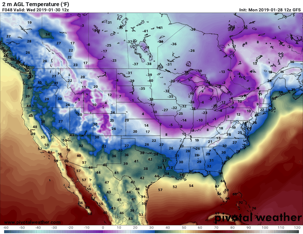
Predicted near-surface air temperatures (F) for Wednesday morning, Jan. 30, 2019. Forecast by NOAA’s Global Forecast System model. Pivotal Weather, CC BY-ND

Predicted near-surface air temperature differences (C) from normal, relative to 1981-2010.
Pivotal Weather, CC BY-ND
In the past several years, thanks to previous cold waves, the polar vortex has become entrenched in our everyday vocabulary and served as a butt of jokes for late-night TV hosts and politicians. But what is it really? Is it escaping from its usual Arctic haunts more often? And a question that looms large in my work: How does global warming fit into the story?
Rivers of air
Actually, there are two polar vortices in the Northern Hemisphere, stacked on top of each other. The lower one is usually and more accurately called the jet stream. It’s a meandering river of strong westerly winds around the Northern Hemisphere, about seven miles above Earth’s surface, near the height where jets fly.
The jet stream exists all year, and is responsible for creating and steering the high- and low-pressure systems that bring us our day-to-day weather: storms and blue skies, warm and cold spells. Way above the jet stream, around 30 miles above the Earth, is the stratospheric polar vortex. This river of wind also rings the North Pole, but only forms during winter, and is usually fairly circular.
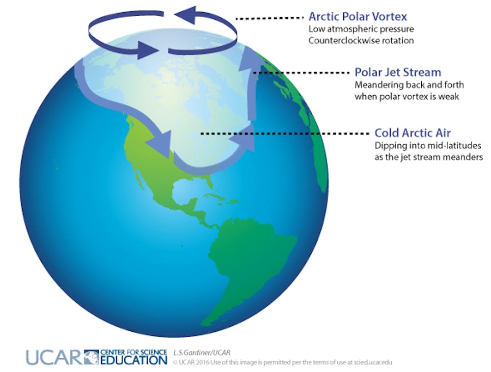
Dark arrows indicate rotation of the polar vortex in the Arctic; light arrows indicate the location of the polar jet stream when meanders form and cold, Arctic air dips down to mid-latitudes. L.S. Gardiner/UCAR, CC BY-ND
Why cold air plunges south
Greenhouse gas emissions from human activities have warmed the globe by about 1.8 degrees Fahrenheit (1 C) over the past 50 years. However, the Arctic has warmed more than twice as much. Amplified Arctic warming is due mainly to dramatic melting of ice and snow in recent decades, which exposes darker ocean and land surfaces that absorb a lot more of the sun’s heat.
Because of rapid Arctic warming, the north/south temperature difference has diminished. This reduces pressure differences between the Arctic and mid-latitudes, weakening jet stream winds. And just as slow-moving rivers typically take a winding route, a slower-flowing jet stream tends to meander.
Large north/south undulations in the jet stream generate wave energy in the atmosphere. If they are wavy and persistent enough, the energy can travel upward and disrupt the stratospheric polar vortex. Sometimes this upper vortex becomes so distorted that it splits into two or more swirling eddies.
These “daughter” vortices tend to wander southward, bringing their very cold air with them and leaving behind a warmer-than-normal Arctic. One of these eddies will sit over North America this week, delivering bone-chilling temperatures to much of the nation.
Deep freezes in a warming world
Splits in the stratospheric polar vortex do happen naturally, but should we expect to see them more often thanks to climate change and rapid Arctic warming? It is possible that these cold intrusions could become a more regular winter story. This is a hot research topic and is by no means settled, but a handful of studies offer compelling evidence that the stratospheric polar vortex is changing, and that this trend can explain bouts of unusually cold winter weather.
Undoubtedly this new polar vortex attack will unleash fresh claims that global warming is a hoax. But this ridiculous notion can be quickly dispelled with a look at predicted temperature departures around the globe for early this week. The lobe of cold air over North America is far outweighed by areas elsewhere in the United States and worldwide that are warmer than normal.
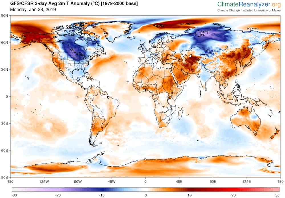
Predicted daily mean, near-surface temperature (C) differences from normal (relative to 1979-2000) for Jan. 28-30, 2019. Data from NOAA’s Global Forecast System model.
Climate Reanalyzer, Climate Change Institute, University of Maine., CC BY-ND
Jennifer Francis, Visiting Professor, Rutgers University
This article is republished from The Conversation under a Creative Commons license. Read the original article.
No comments:
Post a Comment