Tuesday, July 26, 2016

It could be unbearably hot in many places within a few years time


On July 24, 2016, 21:00 UTC, it was 98.7°F or 37.1°C at the green circle on above image. Because humidity at the time was 72% and wind speed was 2 mph or 3 km/h, it felt like it was 140.4°F or 60.2°C.


Above image shows temperatures, i.e. 98.7°F or 37.1°C at the green circle.


Above image shows that relative humidity was 72% at the green circle.


This event occurred at a location on the border of Missouri and Arkansas, just within Missouri, as is also indicated by the red marker above Google Maps image.

As the EPA animation on the right illustrates, a relatively small rise in average temperature can result in a lot more hot and extremely hot weather.

The three images underneath, from the IPCC, show the effect on extreme temperatures when (a) the mean temperature increases, (b) the variance increases, and (c) when both the mean and variance increase for a normal distribution of temperature.

The 'Misery Index' is the perceived air temperature as a combination of wind chill and heat index (which combines air temperature and relative humidity, in shaded areas).

As temperatures and humidity levels keep rising, there comes a point where the wind factor no longer matters, in the sense that wind can no longer provide cooling.

The thermodynamic wet-bulb temperature is determined by temperature, humidity and pressure (hPa), and it is the lowest temperature that can be achieved by evaporative cooling of a water-wetted ventilated surface.

Once the wet-bulb temperature reaches 35°C, one can no longer lose heat by perspiration, even in strong wind, but instead one will start gaining heat from the air beyond a wet-bulb temperature of 35°C.

The above combination of 37.1°C at 72% relative humidity at a pressure of 1013 hPa translates into a wet-bulb temperature of 32.43°C. Had humidity risen to 87% while temperature remained at 37.1°C, the wet-bulb temperature would have risen above 35°C. Alternatively, had the temperature risen to 39.9°C while humidity remained at 72%, the wet-bulb temperature would also have risen above 35°C.

This goes to show how close the world is to unbearable heat. After all, this event occurred in Missouri, i.e. at some distance from the Equator, implying that, as temperatures and humidity levels keep rising, it could be unbearably hot in many places within a few years time.

As discussed in a recent post and illustrated by the image on the right, the world could be 10°C or 18°F warmer in ten years time. Accordingly, this would lead to numbers of climate-related global deaths in line with the prognosis below.


The situation is dire and calls for comprehensive and effective action as described in the Climate Plan.


Links

• Climate Plan
https://arctic-news.blogspot.com/p/climateplan.html

• Wet-bulb temperature
https://en.wikipedia.org/wiki/Wet-bulb_temperature

• What is Wet Bulb temperature? By Steven Sherwood
http://web.science.unsw.edu.au/~stevensherwood/wetbulb.html

• NOAA wet bulb calculator
http://www.srh.noaa.gov/epz/?n=wxcalc_rh

• Dry Bulb, Wet Bulb and Dew Point temperatures
http://www.engineeringtoolbox.com/dry-wet-bulb-dew-point-air-d_682.html

• Heat Index
https://en.wikipedia.org/wiki/Heat_index
http://www.nws.noaa.gov/os/heat/heat_index.shtml

• NOAA Heat Index calculator
http://www.wpc.ncep.noaa.gov/html/heatindex.shtml

• Wind chill
https://en.wikipedia.org/wiki/Wind_chill

• NOAA Meteorological Conversions and Calculations
http://www.wpc.ncep.noaa.gov/html/calc.shtml

• An adaptability limit to climate change due to heat stress - by Steven Sherwood and Matthew Huber
http://www.pnas.org/content/107/21/9552.abstract

• The Deadly Combination of Heat and Humidity
http://www.nytimes.com/2015/06/07/opinion/sunday/the-deadly-combination-of-heat-and-humidity.html

• Researchers find future temperatures could exceed livable limits
http://www.purdue.edu/newsroom/research/2010/100504HuberLimits.html

• Intergovernmental Panel of Climate Change (IPCC), 3rd Assessment Report, Working Group I: The Scientific Basis
https://www.ipcc.ch/ipccreports/tar/wg1/088.htm

• A Global Temperature Rise Of More than Ten Degrees Celsius By 2026?
https://arctic-news.blogspot.com/2016/07/a-global-temperature-rise-of-more-than-ten-degrees-celsius-by-2026.html

• WMO examines reported record temperature of 54°C in Kuwait, Iraq
http://public.wmo.int/en/media/news/wmo-examines-reported-record-temperature-of-54°c-kuwait

• Extinction
https://arctic-news.blogspot.com/p/extinction.html


Sunday, July 17, 2016

High Methane Levels Follow Earthquake in Arctic Ocean

In the 12 months up to July 14, 2016, 48 earthquakes with a magnitude of 4 or higher on the Richter scale hit the map area of the image below, mostly at a depth of 10 km (6.214 miles).


As temperatures keep rising and as melting of glaciers keeps taking away weight from the surface of Greenland, isostatic rebound can increasingly trigger earthquakes around Greenland, and in particular on the faultline that crosses the Arctic Ocean.

Two earthquakes recently hit the Arctic Ocean. One earthquake hit with a magnitude of 4.5 on the Richter scale on July 9, 2016. The other earthquake hit with a magnitude of 4.7 on the Richter scale on July 12, 2016, at 00:15:24 UTC, with the epicenter at 81.626°N 2.315°W and at a depth of 10.0 km (6.214 miles), as illustrated by the image below.


Following that most recent earthquake, high levels of methane showed up in the atmosphere on July 15, 2016, over that very area where the earthquake hit, as illustrated by the image below.


Above image shows that methane levels were as high as 2505 ppb at an altitude of 4,116 m or 13,504 ft on the morning of July 15, 2016. At a higher altitude (of 6,041 m or 19,820 ft), methane levels as high as 2598 ppb were recorded that morning and the magenta-colored area east of the north-east point of Greenland (inset) looks much the same on the images in between those altitudes. All this indicates that the earthquake did cause destabilization of methane hydrates contained in sediments in that area.

Above image, from another satellite, confirms strong methane releases east of Greenland on the afternoon of July 14, 2016, while the image below shows high methane levels on July 16, 2016, along the faultline that crosses the Arctic Ocean.


The image on the right shows glaciers on Greenland and sea ice near Greenland and Svalbard on July 15, 2016. Note that clouds partly obscure the extent of the sea ice decline.


Above image shows the sea ice on July 12, 2016. There is a large area with very little sea ice close to the North Pole (left) and there is little or no sea ice around Franz Josef Land (right). Overall, sea ice looks slushy and fractured into tiny thin pieces. All this is an indication how warm the water is underneath the sea ice.

[ click on image to enlarge ]
In addition to the shocks and pressure changes caused by earthquakes, methane hydrate destabilization can be triggered by ocean heat reaching the seafloor of the Arctic Ocean. Once methane reaches the atmosphere, it can very rapidly raise local temperatures, further aggravating the situation.

Temperatures are already very high across the Arctic, as illustrated by the image below, showing that on July 16, 2016, it was 1.6°C or 34.8°F over the North Pole (top green circle), while it was 32.7°C or 90.8°F at a location close to where the Mackenzie River flows into the Arctic Ocean (bottom green circle).

Arctic sea ice is in a very bad shape, as also illustrated by the Naval Research Laboratory nowcast below.


Sea ice thickness has fallen dramatically over the years, especially the ice that was more than 2.5 m thick. The image below compares the Arctic sea ice thickness (in m) on July 15, for the years from 2012 (left panel) to 2015 (right panel), using Naval Research Laboratory images.

[ Click on image to enlarge ]
The image below shows sea surface temperature anomalies from 1961-1990 on July 24, 2016.


Sea surface temperatures off the coast of America are high and much of this ocean heat will be carried by the Gulf Stream toward the Arctic Ocean over the next few months.


On July 24, 2016, sea surface temperature near Florida was as high as 33.2°C or 91.7°F, an anomaly of 3.7°C or 6.6°F from 1981-2011 (bottom green circle), while sea surface temperature near Svalbard was as high as 17.3°C or 63.2°F, an anomaly of 12.6°C or 22.8°F from 1981-2011 (top green circle).

A cold freshwater (i.e. low salinity) lid sits on top of the ocean and this lid is fed by precipitation (rain, hail, snow, etc.), melting sea ice (and icebergs) and water running off the land (from rivers and melting glaciers on land). This lid reduces heat transfer from ocean to atmosphere, and thus contributes to a warmer North Atlantic where huge amounts of heat are now carried underneath this lid toward the Arctic Ocean. The danger is that more ocean heat arriving in the Arctic Ocean will destabilize clathrates at the seafloor and result in huge methane eruptions, as discussed in earlier posts such as this one.

As temperatures keep rising, snow and ice in the Arctic will decline. This could result in some 1.6°C or 2.88°F of warming due to albedo changes (i.e. due to decline both of Arctic sea ice and of snow and ice cover on land). Additionally, some 1.1°C or 2°F of warming could result from methane releases from clathrates at the seafloor of the world's oceans. As discussed in an earlier post, this could eventuate as part of a rise from pre-industrial levels of as much as 10°C or 18°F, by the year 2026.

[ click on image to enlarge ]


The impact of rising temperatures will be felt firstly and most strongly in the Arctic, where global warming is accelerating due to numerous feedbacks that can act as self-reinforcing cycles.

Already now, this is sparking wildfires across the Arctic.

Above image shows wildfires (indicated by the red dots) in Alaska and north Canada, on July 15, 2016.

The image on the right shows smoke arising from wildfires on Siberia. The image below shows that, on July 18, 2016, levels of carbon monoxide (CO) over Siberia were as high as 32318 ppb, and in an area with carbon dioxide (CO2) levels as low as 345 ppm, CO2 reached levels as high as 650 ppm on that day.

[ click on images to enlarge them ]
The image below shows the extent of smoke from wildfires in Siberia on July 23, 2016.


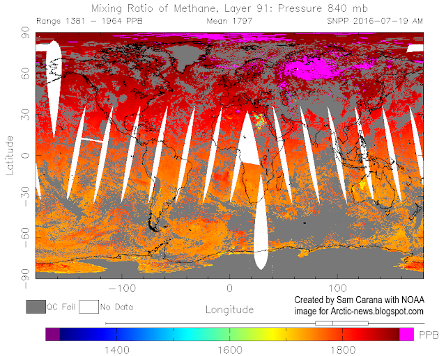
The image below shows high methane levels over Siberia on July 19, 2016.


The image below, from the MetOp satellite, shows high methane levels over Siberia on July 21, 2016.

Below are further images depicting mean global methane levels, from 1980-2016 (left) and 2012-2016 (right).

The image below shows methane levels at Barrow, Alaska.


The image below shows that, while methane levels may appear to have remained stable over the past year when taking measurements at ground level, at higher altitudes they have risen strongly.


The conversion table below shows the altitude equivalents in feet, m and mb.
57016 feet44690 feet36850 feet30570 feet25544 feet19820 feet14385 feet 8368 feet1916 feet
17378 m13621 m11232 m 9318 m 7786 m 6041 m 4384 m 2551 m 584 m
 74 mb 147 mb 218 mb 293 mb 367 mb 469 mb 586 mb 742 mb 945 mb

The situation is dire and calls for comprehensive and effective action, as described at the Climate Plan.


Friday, July 15, 2016

A Global Temperature Rise Of More than Ten Degrees Celsius By 2026?

How much have temperatures risen and how much additional warming could eventuate over the next decade? The image on the right shows a potential global temperature rise by 2026 from pre-industrial levels. This rise contains a number of elements, as discussed below from the top down.

February 2016 rise from 1900 (1.62°C)

The magenta element at the top reflects the temperature rise since 1900. In February 2016, it was 1.62°C warmer compared to the year 1900, so that's a rise that has already manifested itself.

Rise from pre-industrial levels to 1900 (0.3°C)

Additional warming was caused by humans before 1900. Accordingly, the next (light blue) element from the top down uses 0.3°C warming to reflect anthropogenic warming from pre-industrial levels to the year 1900.

When also taking this warming into account, then it was 1.92°C (3.46°F) warmer in February 2016 than in pre-industrial times, as is also illustrated on the image below.


Warming from the other elements (described below) comes on top of the warming that was already achieved in February 2016.

Rise due to carbon dioxide from 2016 to 2026 (0.5°C)

The purple element reflects warming due to the amount of carbon dioxide in the atmosphere by 2026. While the IEA reported that energy-related carbon dioxide emissions had not risen over the past few years, carbon dioxide levels in the atmosphere have continued to rise, due to feedbacks that are kicking in, such as wildfires and reduced carbon sinks. Furthermore, maximum warming occurs about one decade after a carbon dioxide emission, so the full warming wrath of the carbon dioxide emissions over the past ten years is still to come. In conclusion, an extra 0.5°C warming by 2026 seems possible as long as carbon dioxide levels in the atmosphere and oceans remain high and as temperatures keep rising.

Removal of aerosols masking effect (2.5°C)

With dramatic cuts in emissions, there will also be a dramatic fall in aerosols that currently mask the full warming of greenhouse gases. From 1850 to 2010, anthropogenic aerosols brought about a decrease of ∼2.53 K, says a recent paper. While on the one hand not all of the aerosols masking effect may be removed over the next ten years, there now are a lot more aerosols than in 2010. A 2.5°C warming due to removal of part of the aerosols masking effect therefore seems well possible by the year 2026.

Albedo changes in the Arctic (1.6°C) 

Warming due to Arctic snow and ice loss may well exceed 2 W per square meter, i.e. it could more than double the net warming now caused by all emissions by people of the world, calculated Professor Peter Wadhams in 2012. A 1.6°C warming due to albedo changes (i.e. decline of both Arctic sea ice and snow and ice cover on land) therefore seems well possible by the year 2026.

Methane eruptions from the seafloor (1.1°C)

". . we consider release of up to 50 Gt of predicted amount of hydrate storage as highly possible for abrupt release at any time," Dr. Natalia Shakhova et al. wrote in a paper presented at EGU General Assembly 2008. Authors found that such a release would cause 1.3°C warming by 2100. Note that such warming from an extra 50 Gt of methane seems conservative when considering that there now is only some 5 Gt of methane in the atmosphere, and over a period of ten years this 5 Gt is already responsible for more warming than all the carbon dioxide emitted by people since the start of the industrial revolution. Professor Peter Wadhams co-authored a study that calculated that methane release from the seafloor of the Arctic Ocean could yield 0.6°C warming of the planet in 5 years (see video at earlier post). In conclusion, as temperatures keep rising, a 1.1°C warming due to methane releases from clathrates at the seafloor of the world's oceans seems well possible by the year 2026.

Extra water vapor feedback (2.1°C)

Rising temperatures will result in more water vapor in the atmosphere (7% more water vapor for every 1°C warming), further amplifying warming, since water vapor is a potent greenhouse gas. Extra water vapor will result from warming due to the above-mentioned albedo changes in the Arctic and methane releases from the seafloor that could strike within years and could result in huge warming in addition to the warming that is already there now. As the IPCC says: "Water vapour feedback acting alone approximately doubles the warming from what it would be for fixed water vapour. Furthermore, water vapour feedback acts to amplify other feedbacks in models, such as cloud feedback and ice albedo feedback. If cloud feedback is strongly positive, the water vapour feedback can lead to 3.5 times as much warming as would be the case if water vapour concentration were held fixed", according to the IPCC. Given a possible additional warming of 2.7°C due to just two elements, i.e. Arctic albedo changes and seafloor methane, an additional warming over the next decade of 2.1°C due to extra water vapor in the atmosphere therefore does seem well possible by the year 2026.

Further feedbacks (0.3°C)

Further feedbacks will result from interactions between the above elements. Additional water vapor in the atmosphere and extra energy trapped in the atmosphere will result in more intense storms and precipitation, flooding and lightning. Flooding can cause rapid decomposition of vegetation, resulting in strong methane releases. Furthermore, plumes above the anvils of severe storms can bring water vapor up into the stratosphere, contributing to the formation of cirrus clouds that trap a lot of heat that would otherwise be radiated away, from Earth into space. The number of lightning strikes can be expected to increase by about 12% for every 1°C of rise in global average air temperature. At 3-8 miles height, during the summer months, lightning activity increases NOx by as much as 90% and ozone by more than 30%. The combination of higher temperatures and more lightning will also cause more wildfires, resulting in emissions such as of methane and carbon monoxide. Ozone acts as a direct greenhouse gas, while ozone and carbon monoxide can both act to extend the lifetime of methane. Such feedbacks may well result in an additional 0.3°C warming by the year 2026.

Total potential global temperature rise by 2026 (10°C or 18°F)

Adding up all the warming associated with the above elements results in a total potential global temperature rise (land and ocean) of more than than 10°C or 18°F within a decade, i.e. by 2026. As said before, this scenario assumes that no geoengineering will take place over the next decade.

The situation is dire and calls for comprehensive and effective action as described in the Climate Plan.


Sunday, July 10, 2016

Extreme Weather Events


Sea ice close to the North Pole looks slushy and fractured into small pieces. The image below shows the situation on July 8, 2016.

Sea ice north of the geographic North Pole. For more on the (geo)magnetic North Pole, see this page
For reference, the bars at the bottom right show distances of 20 km and 20 miles. By comparison, sea ice in the same area did develop large cracks in 2012, but even in September 13, 2012, it was not broken up into small pieces, as shown by this image at a recent post.


As shown by above image, by Jim Pettit, Arctic sea ice volume has been in decline for decades. While this may look like a steady decline, chances are that the sea ice will abruptly collapse over the next two months, for the reasons described below.

The animation below, from the Naval Research Laboratory, shows Arctic sea ice thickness for 30 days up through July 8, 2016, including a forecast of 7 days.

Below is a new Naval Research Laboratory image, dated July 4, 2016
and contributed by Albert Kallio with the following description.


NORTH POLE SEA ICE DISAPPEARING VERY RAPIDLY 4.7.2016

Albert Kallio: The upgraded US Navy sea ice thickness system revealed extreme rates of sea ice pulverization and melting on 4.7.2016 which justifies a continued close attention to the developments on the Arctic Ocean. Due to virtually continuous storm centering the North Pole for weeks now, warm water upswells and sea water mixing drives base melting of icefloes besides wave actions that both wash and pulverize broken sea ice. The more pulverized sea ice becomes, the greater its 3-dimensional surface area that sits in water becomes, this easing transfer of heat from ocean to sea ice. In addition, honeycombing of ice also flushes ice with water in a stormy weather. The final factor being that most of sea ice is very recent (seasonal) ice that contain residues of salts, when saline brine is expelled this creates boreholes into ice making it "rotten ice" easily.
https://www7320.nrlssc.navy.mil/GLBhycomcice-12/navo/arcticictn_nowcast_anim30d.gif
Sea ice decline reflects the extra energy added to the Arctic, as global warming and feedbacks are hitting the Arctic particularly strongly. Three of these feedbacks are depicted in the image on the right.

As the sea ice melts, sea surface temperatures will remain at around zero degree Celsius (32°F) for as long as there is ice in the water, since the extra energy will first go into melting the ice. Only after the ice has melted will the extra energy start raising the temperature of the water.

Sea ice thus acts as a buffer that absorbs heat, preventing sea surface temperature from rising. As
sea ice is busy melting, each gram of ice takes 334 Joule of heat to change into water, while the temperature remains steady at 0°C ( 32°F).

Once all ice has turned into water, all further heat goes into raising the temperature of the water. To raise the temperature of each gram of water by one degree Celsius then takes only 4.18 Joule of heat.

In other words, melting of the ice absorbs 8 times as much heat as it takes to warm up the same mass of water from zero to 10°C. As sea ice disappears, extra energy instead goes into raising the temperature of the water, as depicted in the image on the right, and as further described at the feedbacks page as feedback #14.

Sea ice can reflect as much as 90% of the sunlight back into space. Once the ice has melted away, the water of the ocean reflects only 6% of the incoming solar radiation and absorbs the rest. Albedo change is depicted in above image as feedback #1. As Professor Peter Wadhams once calculated, warming due to Arctic snow and ice loss could more than double the net warming now caused by all emissions by all people of the world.

Professor Peter Wadhams on albedo changes in the Arctic, image from Edge of Extinction
Once the sea ice has disappeared, a lot more energy will get absorbed by the Arctic Ocean, i.e. energy that was previously reflected back into space and energy that previously went into changing ice into water.

Furthermore, as the sea ice disappears, chances increase that storms will develop that come with rain and winds that can batter and push the remaining sea ice out of the Arctic Ocean, while storms can also increase the amount of water vapor in the atmosphere and the occurrence of cirrus clouds that can trap heat.

Methane is a further feedback, depicted as feedback #2 in the image further above. As the water of the Arctic Ocean gets warmer, the danger increases that heat will reach hydrates at the seafloor and that this will trigger release of huge amounts of methane, in an additional self-reinforcing feedback loop that will make warming in the Arctic accelerate further and that threatens to escalate into a third kind of warming, i.e. runaway warming. Peter Wadhams co-authored a study that calculated that methane release from the seafloor of the Arctic Ocean could yield 0.6°C warming of the planet in 5 years (see video at earlier post).


As above image shows, methane on July 8, 2016, reached levels as high as 2655 ppb. Such high levels typically occur due to methane hydrates getting destabilized. As the sea ice disappears, the situation could get worse rapidly, as illustrated by the images below.

July 5, 2016, sea surface was as warm as 17.1°C / 62.7°F at green circle, i.e. 13.7°C / 24.7°F warmer than 1981-2011. 
These high sea surface temperature anomalies are the result of warmer water getting carried by the Gulf Stream below the sea surface of the Atlantic Ocean into the Arctic Ocean. The water carried into the Arctic Ocean is both warmer and saltier than the water at the surface, as the fresh cold meltwater forms a lid at the surface. At areas around Svalbard where the sea is rather shallow, the warmer water comes to the surface. These high anomalies thus indicate how much warmer the water now is that is entering the Arctic Ocean, as discussed in earlier posts such as this one.
image from previous post
The rapid recent rise in ocean heat is illustrated by above image, showing that oceans on the Northern Hemisphere in May 2015 through April 2016 were 0.93°C warmer than the 20th century average, whereas for the equivalent 2012 period the anomaly was merely 0.46°C. In other words, there now is more ocean heat, making the possibility of methane hydrates destabilization more threatening.

Meanwhile, the speed at which the Arctic is warming is changing the jet streams, as discussed by Paul Beckwith in the video below, following Paul's earlier video that's included in an earlier post.


There are many indications that changes to the climate are accelerating, causing extreme weather events to hit with increasing strength and intensity. Water vapor is a potent greenhouse gas and for each degree Celsius that temperatures rise, the atmosphere can hold 7% more water vapor, which will also lead to stronger storms such as cyclones. On the image below, typhoon Nepartak is approaching Taiwan, with wind speed as high as 103 mph or 165 km/h, and with cloud water as much as 9 kg per square m on July 7, 2016.

Nepartak approaching Taiwan on July 7, 2016, with wind speed as high as 103 mph or 165 km/h (left panel), and with cloud water as much as 9 kg per square m (right panel)
NASA image
According to NASA, very powerful storms near the center of Nepartak's circulation were found to be dropping rain at a rate of over 193 mm (7.6 inches) per hour. Tall thunderstorms called "hot towers" were found to reach heights of 17.0 km (about 10.5 miles).

The image on the right shows a thermal image of Typhoon Nepartak on July 7 at 17:45 UTC. The colder the cloud tops, the higher they are in the troposphere and the stronger the storms.

On July 7, 2016, at 1500 UTC, Nepartak's maximum sustained winds had reached 150 knots (172.6 mph/ 277.8 kph), generating waves as high as 48 feet (14.6 meters).

Strong storms can bring water vapor high up into the stratosphere, contributing to the formation of cirrus clouds that trap a lot of heat that would otherwise be radiated away, from Earth into space.

Altogether, the combined global temperature rise due to global warming and feedbacks could exceed 10°C or 18°F within a decade, as discussed in previous posts such as this one.

The situation is dire and calls for comprehensive and effective action as described in the Climate Plan.


Links

 The North Geographic Pole, the North Magnetic Pole and the North Geomagnetic Pole
http://wdc.kugi.kyoto-u.ac.jp/poles/polesexp.html

 Three Kinds of Warming in the Arctic
http://arctic-news.blogspot.com/2016/02/three-kinds-of-warming-in-arctic.html

 NASA: Napartak (July 9, 2016)
https://www.nasa.gov/feature/goddard/2016/napartak-nw-pacific-ocean

 Jim Pettit Climate Graphs
http://iwantsomeproof.com/3d/siv-ds-weekly-3d.asp