Saturday, August 25, 2012

How much sea ice is lost daily?

How much sea ice is lost in the Arctic daily? What are your estimates (in square km and cubic km)? 


Paul Beckwith
Paul Beckwith, B.Eng, M.Sc. (Physics),
Ph. D. student (Climatology) and
Part-time Professor, University of Ottawa

Losses of 100,000 square kilometer per day loss of sea ice area are being reported by various sources. Images of ice speed and drift, in conjunction with ice thickness, would support this.

This rate of loss is as large as that lost during the August 3rd to 10th cyclone (700,000 to 800,000 square kilometers lost for the duration of the cyclone).

My prediction that we'll lose virtually all sea ice by September 30th, 2012, still seems very reasonable.


Sam Carana

I too estimate there have been losses of 100,000 square kilometer per day for over two months now.

The top image at my recent post on ice extent shows that extent has roughly halved in two months time, from over 12 million square km at the start of June to roughly 6 million square km at the start of August. That's a loss of about 6 million square km in two months time, or about 100,000 square km per day.

To date, this loss rate appears to have continued in August and shows no signs of decreasing yet.

Cyclone Warning

By Harold Hensel, edited by Sam Carana

The Google Earth view below shows an Arctic Cyclone going over Alaska and entering the Arctic Ocean.

Arctic - Google Earth view
The warm rain and wind will further deteriorate the North Pole Ice Cap.

In case you're looking for news in Tropical Storm ISAAC, see the images below.

Tropical Storm ISAAC - Google Earth view
Tropical Storm ISAAC - NOAA image
Above image and the image below are from the NOAA National Hurricane Center. For updates on ISAAC, check that site!
Tropical Storm ISAAC - NOAA image


Friday, August 24, 2012

Arctic sea ice extent update

The image below shows sea ice extent as calculated by the Polar View team at the University of Bremen, Germany, updated August 25, 2012.


The image below, edited from the National Snow & Ice Data Center (NSIDC), shows the situation according to the NSIDC updated at August 23, 2012. It's clear that Arctic sea ice extent looks set to reach the 2007 record low within days, if it hasn't been reached already now.


For updates, see the daily images produced by the NSIDC. Note that, to calculate extent, both the NSIDC and the Univeristy of Bremen include areas that show at least 15% sea ice. In the image below, from the Danish Meteorological Institute (DMI), areas with ice concentration higher than 30% are included to calculate ice extent.


Monday, August 20, 2012

Record low sea ice area


Arctic sea ice area reached a record low of 2.87746 million square km on the 230th day of 2012, as illustrated on the image below by The Cryosphere Today.


Below the sea surface temperature anomaly for August 20, 2012, by the National Oceanic and Atmospheric Administration (NOAA).


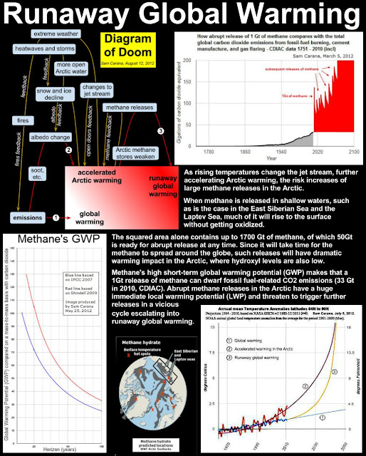
Rising temperatures in the Arctic threaten to trigger methane releases, as shown on the poster below.


The poster forms part of the updated presentation Why act now, and how?