Wednesday, August 13, 2014

Horrific Methane Eruptions in East Siberian Sea

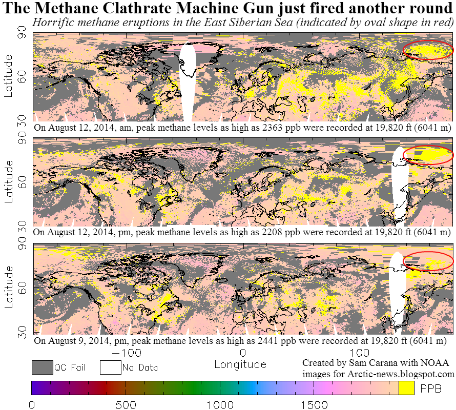
A catastrophe of unimaginable propertions is unfolding in the Arctic Ocean. Huge quantities of methane are erupting from the seafloor of the East Siberian Sea and entering the atmosphere over the Arctic Ocean.


As the top image above shows, peak levels as high as 2363 ppb were recorded at an altitude of 19,820 ft (6041 m) on the morning of August 12, 2014. The middle image shows that huge quantities of methane continued to be present over the East Siberian Sea that afternoon, while the bottom image shows that methane levels as high as 2441 ppb were recorded a few days earlier, further indicating that the methane did indeed originate from the seafloor of the East Siberian Sea.

On August 12, 2014, peak methane levels at higher altitudes were even higher than the readings mentioned on above image. Levels as high as 2367 ppb were reached at an altitude of 36,850 ft (11,232 m). Such high levels have become possible as the huge quantities of methane that were released from the seafloor of the Arctic Ocean over the period from October 2013 to March 2014, have meanwhile descended to lower latitudes where they show up at higher altitudes.

Methane eruptions from the Arctic Ocean's seafloor helped push up mean global methane levels to readings as high as 1832 ppb on August 12, 2014.

Ironically, the methane started to erupt just as an international team of scientists from Sweden, Russia and the U.S. (SWERUS-C3), visiting the Arctic Ocean to measure methane, had ended their research.

Örjan Gustafsson describes part of their work: “Using the mid-water sonar, we mapped out an area of several kilometers where bubbles were filling the water column from depths of 200 to 500 m. During the preceding 48 h we have performed station work in two areas on the shallow shelf with depths of 60-70m where we discovered over 100 new methane seep sites.”

Örjan Gustafsson adds that “a tongue of relatively warm Atlantic water, with a core at depths of 200–600 m may have warmed up some in recent years. As this Atlantic water, the last remnants of the Gulf Stream, propagates eastward along the upper slope of the East Siberian margin, our SWERUS-C3 program is hypothesizing that this heating may lead to destabilization of upper portion of the slope methane hydrates.”

Schematics of key components of the Arctic climate-cryosphere-carbon system that are addressed by the SWE-C3 Program. a,b) Sonar images of gas plumes in the water column caused by sea floor venting of methane (a: slope west of Svalbard, Westbrook et al., 2009; b: ESAO, Shakhova et al., 2010, Science). c) Coastal erosion of organic-rich Yedoma permafrost, Muostoh Island, SE Laptev Sea. d) multibeam image showing pockmarks from gas venting off the East Siberian shelf. e) distribution of Yedoma permafrost in NE Siberia. f) Atmospheric venting of CH₄, CO₂. (SWERUS-C3)
Örjan Gustafsson further adds that SWERUS-C3 researchers have on earlier expeditions documented extensive venting of methane from the subsea system to the atmosphere over the East Siberian Arctic Shelf.

In 2010, team members Natalia Shakhova and Igor Semiletov estimated the accumulated methane potential for the Eastern Siberian Arctic Shelf alone to be as follows:
- organic carbon in permafrost of about 500 Gt;
- about 1000 Gt in hydrate deposits; and
- about 700 Gt in free gas beneath the gas hydrate stability zone.

Back in 2008, Shakhova et al. wrote a paper warning that “we consider release of up to 50 Gt of predicted amount of hydrate storage as highly possible for abrupt release at any time.”

Last year, a team of researchers including Professor Peter Wadhams calculated that such a 50 Gt release would cause global damage with a price-tag of $60 trillion.

As Prof Wadhams explains in the video below: “We really have no choice except to seriously consider the use of geoengineering.”


Sea surface temperatures as high as 18.8°C are now recorded at locations where warm water from the Pacific Ocean is threatening to invade the Arctic Ocean.

At the same time, huge amounts of very warm water are carried into the Arctic Ocean by the Gulf Stream through the North Atlantic. The image below illustrates how the Gulf Stream brings very warm water to the edge of the sea ice.

Waters close to Svalbard reached temperatures as high as 62°F (16.4°C) on July 29, 2014 (green circle). Note that the image below shows sea surface temperatures only. At greater depths (say about 300 m), the Gulf Stream is pushing even warmer water through the Greenland Sea than temperatures at the sea surface.

Since the passage west of Svalbard is rather shallow, a lot of this very warm water comes to the surface at that spot, resulting in an anomaly of 11.1°C. The high sea surface temperatures west of Svalbard thus show that the Gulf Stream can carry very warm water (warmer than 16°C) at greater depths and is pushing this underneath the sea ice north of Svalbard. Similarly, warm water from greater depth comes to the surface where the Gulf Stream pushes it against the west coast of Novaya Zemlya.


[ click on image to enlarge ]
As Malcolm Light writes in an earlier post: The West Spitzbergen Current dives under the Arctic ice pack west of Svalbard, continuing as the Yermak Branch (YB on map) into the Nansen Basin, while the Norwegian Current runs along the southern continental shelf of the Arctic Ocean, its hottest core zone at 300 metres depth destabilizing the methane hydrates en route to where the Eurasian Basin meets the Laptev Sea, a region of extreme methane hydrate destabilization and methane emissions.

The images below give an impression of the amount of heat transported into the Arctic Ocean.


The image below gives an idea how methane eruptions from the seafloor of the Arctic Ocean could unfold over the coming decades. For more on this image, see this post and this page.


As said, the situation is dire and calls for comprehensive and effective action, as discussed at the Climate Plan blog at climateplan.blogspot.com and as illustrated by the image below.


Friday, August 8, 2014

The Arctic Methane Monster's Rapid Rise


Researcher Jennifer Hynes recently gave a frightening presentation about the situation in the Arctic and the odds that things will rapidly spiral out of control soon, escalating into runaway global warming a few decades from now. 


Above, a slide from the presentation, warning about the danger of earthquakes causing methane hydrate destabilization (from: Smoke Blankets North America). As the map below shows, 77 M4+ earthquakes did hit locations around Greenland in the year 2014 up until August 4.


Below is Jennifer's presentation, also on youtube at youtube.com/watch?v=a9PshoYtoxo


The image below shows sea surface temperature anomalies in the Arctic at August 7, 2014.


Warm water is carried into the Arctic Ocean by the Gulf Stream, as illustrated by the image below.
[ click on image to enlarge ]
The image shows how the Gulf Stream brings warm water to the edge of the sea ice. Waters close to Svalbard reached temperatures as high as 15.6°C (60.1°F) on August 8, 2014 (green circle). Note that what the image shows are sea surface temperatures only. At greater depths (say 300 m), warm water is pushed through the Greenland Sea by the Gulf Stream. Since the passage west of Svalbard is rather shallow, a lot of this warm water comes to the surface there. The high sea surface temperatures west of Svalbard thus indicate that the Gulf Stream is carrying very warm water (warmer than 15°C) at greater depths and is pushing this underneath the sea ice north of Svalbard.

As said, the situation is dire and calls for comprehensive and effective action, as discussed at the Climate Plan blog at climateplan.blogspot.com and as illustrated by the image below.


Monday, August 4, 2014

Warm waters threaten to trigger huge methane eruptions from Arctic Ocean seafloor

The evidence of abrupt high methane releases in the Arctic Ocean is accumulating. The graph below shows in situ methane measurements taken at the Barrow Observatory, including recent levels as high as close to 2200 parts per billion (ppb).


Satellite data picture a similarly dire situation. Global mean methane levels as high as 1831 ppb were recorded on the morning of July 30, 2014, while peak methane levels as high as 2330 ppb were recorded that morning. More recently, peak methane levels as high as 2522 ppb were recorded (on August 2, 2014).

IPCC/NOAA figures suggest that methane levels were rising by some 5 to 6 ppb annually, reaching 1814 ppb in 2013. While methane levels at lower altitudes have indeed shown little rise, much larger rises have been recorded at higher altitudes, as illustrated by the image below.


These high methane levels recorded at higher altitudes appear to be caused by the huge quantities of methane released from the seafloor of the Arctic Ocean during the period from end 2013 to early 2014. This methane has meanwhile risen to higher altitudes, while also descending to lower latitudes, wreaking havoc on weather patterns around latitude 60° North.

The releases of methane from the seafloor of the Arctic Ocean were caused by water that had warmed up strongly off the east coast of North America from June 2013. It took some months for this warm water to be carried by the Gulf Stream into the Arctic Ocean.


Meanwhile, very high sea surface temperatures are recorded in the Arctic Ocean, as above image shows, while warm water is carried into the Arctic Ocean by the Gulf Stream, as illustrated by the image below.


As said, the situation is dire and calls for comprehensive and effective action, as discussed at the Climate Plan blog.


Tuesday, July 29, 2014

More than 2.5m Sea Level Rise by 2040?

A warming period more than 400,000 years ago pushed the Greenland ice sheet past its stability threshold (which may have been no more than several degrees above pre-industrial temperatures). This resulted in a nearly complete deglaciation of southern Greenland, raising global sea levels some 4.5-6 meters, found a recent study by Reyes et al. Due to melting elsewhere, global mean sea level then was 6 to 13 metres above the present level. Indeed, melting of the entire West Antarctic Ice Sheet can add a further 6-meter rise in sea levels. If the East Antarctic Ice Sheet (EAIS) were to melt as well, sea levels would rise by around 70 metres.

Sea level is now rising by 3.1mm (0.122 inch) per year. Much of this rise is due to rising temperatures, but there are also other factors. One quarter of the rise results from groundwater depletion, while run off from melting ice and glaciers adds another quarter and the remainder is attributed to thermal expansion of sea water. Furthermore, as temperatures rise, feedbacks start to kick in, e.g. the kinetic energy from stronger waves and more intense storms can speed things up.

Clearly, a rapid multi-meter rise would be devastating as it would flood many coastal cities, as well as much of the land now used to grow food. By how much have sea levels been rising recently and how fast can they be expected to rise in the near future?
NASA image, data by the JPL PODAAC, in support of the NASA's MEaSUREs program.
Sea levels have risen by some 60 mm over the past 20 years, as above NASA image shows, which has a linear trendline added. The question is whether a linear trendline is the most appropriate trendline, given that it suggests that a similar rise could be expected over the next 20 years. A polynomial trendline appears to fit the data better, as the animation below shows.


Such a polynomial trendline, however, points at a similar rise (of some 50 mm) in just four years time, with an even more steeper rise to follow, as illustrated by the image below.


And indeed, such a rise doesn't slow down there. A polynomial trendline applied to the data points at a sea level rise of more than 2.5 m (8.2 ft) by the year 2040.


The image below gives an idea of what a sea level rise of six feet (1.829 m) would do to the City of New York. Of course, this is only the sea level rise. Storm surge would come on top of this, as discussed at Ten Dangers of Global Warming.


So, what would be more appropriate, to expect sea levels to continue to rise in a linear way, or to take into account feedbacks that could speed things up? Where such feedbacks could lead to is illustrated by the image below.
[ from: How many deaths could result from failure to act on climate change? click on image to enlarge ]
This calls for comprehensive and effective action, as discussed at the Climate Plan blog.


References

- South Greenland ice-sheet collapse during Marine Isotope Stage 11, Reyes et al. (2014)
http://www.nature.com/nature/journal/v510/n7506/full/nature13456.html

- Nonsustainable groundwater sustaining irrigation: A global assessment, Yoshihide Wada et al. (2012)
http://onlinelibrary.wiley.com/doi/10.1029/2011WR010562/abstract

- Groundwater Depletion Linked to Rising Sea Levels
http://www.waterworld.com/articles/2010/11/groundwater-depletion-linked-to-rising.html

- Assessment of the Jason-2 Extension to the TOPEX/Poseidon, Jason-1 Sea-Surface Height Time Series for Global Mean Sea Level Monitoring, Beckley et al. (2010)
http://www.tandfonline.com/doi/abs/10.1080/01490419.2010.491029

- Feedbacks in the Arctic
http://climateplan.blogspot.com/p/feedbacks.html

- How many deaths could result from failure to act on climate change? (2014)
http://arctic-news.blogspot.com/2014/05/how-many-deaths-could-result-from-failure-to-act-on-climate-change.html


Monday, July 21, 2014

Methane rising through fractures

by Harold Hensel


Methane is colorless and odorless and it is right above us in the atmosphere.

In addition to other sources, methane has traveled from the Arctic and has blanketed most of the Northern Hemisphere.

The well-known sources are methane hydrates from the Arctic Ocean floor and methane coming from thawing permafrost.

There is also another less well-known source. During the geologic history of the Arctic area, tectonic plates have spread, crashed into each other and subducted under one another. Geologists call the Arctic a tectonic plate junkyard. There are numerous fractures in the earth's crust there.

A quote from earth scientist Malcolm Light: ‘Mantle methane formed from the reduction of oceanic carbonates by water in the presence of iron (II) oxides buried to depths of 100 km to 300 km in the Asthenosphere and at temperatures above 1200°C.’ This is a nonorganic source of methane formed near the earth's mantel. Katey Walter Anthony from the University of Alaska calls it geologic methane.

Vast reservoirs of methane have been created by chemical reactions and stored near the mantle under a lot of pressure for millennia.

The methane has had a route to the surface through the fractures in the earth's crust, but the fractures have been sealed over by ice. Now for the first time in human history, the ice sealing the fractures is thawing. Methane is rising through the fractures and into the atmo­sphere. This methane has migrated to the United States and is over us.


Harold Hensel, 
Cedar Rapids.
Earlier published as 
Letter to the Editor 
Cedar Rapids Gazette 
(without images)


Related

- Study: Geologic methane seeping from thawing cryosphere - by Marmian Grimes
http://uafcornerstone.net/study-geologic-methane-seeping-from-thawing-cryosphere

- Focus on Methane - by Malcolm Light
http://arctic-news.blogspot.com/2014/07/focus-on-methane.html

- Arctic Atmospheric Methane Global Warming Veil - by Malcolm Light, Harold Hensel and Sam Carana

- Mantle Methane - by Malcolm Light


Friday, July 18, 2014

Smoke Blankets North America


A thick layer of smoke blankets large parts of North America, as also illustrated by the animation below based on images from July 15 to 18, 2014, from Wunderground.com.

[ note that this animation is a 2.3MB file that may take some time to fully load ]
The are also extensive wildfires throughout the boreal forest and tundra zones of Central Siberia in Russia.

Such wildfires can send huge amounts of carbon dioxide, methane, soot, dust and volatile organic compounds into the atmosphere. Much of this gets deposited at higher latitudes, discoloring land, snow and ice, and thus speeding up warming by absorbing more sunlight that was previously reflected back into space.

Soils at higher latitudes can contain huge amounts of carbon in the form of peat, as described in the earlier post The Threat of Wildfires in the North. There are further conditions that make the situation in the Arctic so dangerous.
Temperature anomaly March-April-May-June 2014 (JMA)

The Arctic is particularly vulnerable to warming due to geographics. Seas in the Arctic Ocean are often shallow and covered by sea ice that is disappearing rapidly. Largely surrounded by land that is also rapidly losing its snow and ice cover, the Arctic Ocean acts like a trap capturing heat carried in by the Gulf Stream, which brings in ever warmer water. Of all the heat trapped on Earth by greenhouse gases, 90% goes into oceans, while a large part of the remaining 10% goes into melting the snow and ice cover in the Arctic, as described in an earlier post. Such basic conditions make that the Arctic is prone to warming.

Then, there are huge amounts of methane held in sediments under the Arctic Ocean, in the form of hydrates and free gas. Unlike methane releases from biological sources elsewhere on Earth, methane can be released from the seafloor of the Arctic Ocean in large quantities, in sudden eruptions that are concentrated in one area.

Until now, permafrost and the sea ice have acted as a seal, preventing heat from penetrating these methane hydrates and causing further destabilization. As long as there is ice, additional energy will go into melting the ice, and temperatures will not rise. The ice also acts as a glue, keeping the soil together and preventing hydrate destabilization from pressure changes and shockwaves resulting from seismic activity. Once the ice is gone, sediments become prone to destabilization and heat can more easily move down along fractures in the sediment, reaching hydrates that had until then remained stable.
 
Temperature anomaly March-April-May 2014 (NASA)
When methane escapes from the seafloor of the Arctic Ocean and travels through waters that are only shallow, there is little opportunity for this methane to be broken down in the water, so a lot of it will enter the atmosphere over the Arctic Ocean. The Coriolis effect will spread the methane sideways, but latitudes over the Arctic are relatively short, making the methane return at the same spot relatively quickly, while the polar jet stream acts as a barrier keeping much of the methane within the Arctic atmosphere. In case of large methane eruptions, the atmosphere over the Arctic will quickly become supersaturated with methane that has a huge initial local warming potential.

Hydroxyl levels in the atmosphere over the Arctic are very low, extending the lifetime of methane and other precursors of stratospheric ozone and water vapor, each of which have a strong short-term local warming potential. In June/July, insolation in the Arctic is higher than anywhere else on Earth, with the potential to quickly warm up shallow waters, making that heat can penetrate deep into sediments under the seafloor.

created by Sam Carana, part of AGU 2011 poster
The initial impact of this methane will be felt most severely in the Arctic itself, given the concentrated and abrupt nature of such releases, with the danger that even relatively small releases of methane from the seafloor of the Arctic can trigger further destabilization of hydrates and further methane releases, escalating into runaway warming.

This danger is depicted in the image on the right, showing how albedo changes and methane releases act as feedbacks that further accelerate warming in the Arctic, eventually spiraling into runaway global warming.

The currently very high sea surface temperature anomalies are illustrated by the two images below.


As the image below right shows, sea surface temperatures as high as 18 degrees Celsius (64.4 degrees Fahrenheit) are currently recorded in the Arctic.

Albedo changes and methane releases are only two out of numerous feedbacks that are accelerating warming in the Arctic.

Also included must be the fact that Earth is in a state of energy imbalance. Earth is receiving more heat from sunlight than it is emitting back into space. Over the past 50 years, the oceans have absorbed about 90% of the total heat added to the climate system, while the rest goes to melting sea and land ice, warming the land surface and warming and moistening the atmosphere.

In a 2005 paper, James Hansen et al. estimated that it would take 25 to 50 years for Earth’s surface temperature to reach 60% of its equilibrium response, in case there would be no further change of atmospheric composition. The authors added that the delay could be as short as ten years.

Earth's waters act as a buffer, delaying the rise in land surface temperatures that would otherwise occur, but this delay could be shortened. Much of that extra ocean heat may enter the atmosphere much sooner, e.g. as part of an El Niño event. Another buffer, Arctic sea ice, could collapse within years, as illustrated by the image below.

[ click on image to enlarge ]
The demise of sea ice comes with huge albedo changes, resulting in more heat getting absorbed by the Arctic Ocean, in turn speeding up warming of the often shallow waters of the Arctic Ocean. This threatens to make heat penetrate subsea sediments containing huge amounts of methane. Abrupt release of large amounts of methane would warm up the Arctic even more, triggering even further methane releases in a spiral of runaway warming.

Particularly worrying is the currently very warm water that is penetrating the Arctic Ocean from the Atlantic Ocean and also from the Pacific Ocean, as illustrated by the image further above and the image on the right.

The danger is that the Arctic will warm rapidly with decline of the snow and ice cover that until now has acted as a buffer absorbing heat, with more sunlight gets absorbed due to albedo changes and as with additional emissions, particularly methane, resulting from accelerating warming in the Arctic.

The numerous feedbacks that accelerate warming in the Arctic are pictured in the image below.

[ from: climateplan.blogspot.com/p/feedbacks.html ]
Furthermore, the necessary shift to clean energy will also remove the current masking effect of aerosols emitted when burning fuel. One study finds that a 35% – 80% cut in people's emission of aerosols and their precursors will result in about 1°C of additional global warming.

In the video below and the video further down below, Guy McPherson discusses Climate Change and Human Extinction.


This is further illustrated by the image below, showing how surface temperature rises are accelerating in the Arctic compared to global rises, with trendlines added including one for runaway global warming, from How many deaths could result from failure to act on climate change?
[ click on image to enlarge ]
The situation is dire and calls for comprehensive and effective action, as discussed at the Climate Plan blog.

Hat tip to Jim Kirkcaldy for pointing at the wildfire development at an early stage.

Monday, July 14, 2014

Focus on Methane

by Malcolm Light

Methane formed by organisms in the water becomes trapped in the fabric of water ice crystals when it freezes and is stable below about 300 metres depth in the Arctic Ocean.

There are such massive methane reserves below the Arctic Ocean floor that they represent around 100 times the amount that is required to cause a Permian style major extinction event, should the methane be released into the atmosphere.

There are also giant reservoirs of mantle methane, originally sealed in by shallow methane hydrate plugs in fractures cutting the Arctic seafloor.

Unfortunately for us, global warming has heated up the oceanic currents fed by the Gulf Stream flowing into the Arctic, causing massive destabilization of the subsea methane hydrates and fault seals and releasing increasing volumes of methane directly into the atmosphere.

Screenshot from Perdue University's Vulcan animation, which
shows pollution from North America spreading over the North
Atlantic, from Warming of the Arctic Fueling Extreme Weather
The volume transport of the Gulf Stream has increased by three times since the 1940s due to the rising atmospheric pressure difference set up between the polluted, greenhouse gas rich air above North America and the marine Atlantic air.

The increasingly heated Gulf Stream, with its associated high winds and energy rich weather systems, flows NE to Europe where it recently pummelled Great Britain with catastrophic storms. Other branches of the Gulf Stream then enter the Arctic and heat up the Arctic methane hydrate seals on subsea and deep high - pressure mantle methane reservoirs below the Eurasian Basin- Laptev Sea transition.

This is releasing increasing amounts of methane into the atmosphere contributing to anomalous temperatures, greater than 20 degree C above average. Over very short time periods of a few days to a few months the atmospheric methane has a warming potential from 1000 to 100 times that of carbon dioxide.

The amount of carbon stored in hydrates globally
was in 1992 estimated to be 10,000 Gt (USGS),
while a later source gives a figure of 63,400 Gt C
for the Klauda & Sandler (2005) estimate of marine
hydrates. A warming Gulf Stream causes methane
eruptions
 off the North American coast. Methane also
appears to be erupting from hydrates on Antarctica,
on the Qinghai-Tibetan Plateau and on Greenland.
In just one part of the Arctic Ocean alone, the East
Siberian Arctic Shelf (ESAS), up to 1700 Gt of
methane is contained in sediments in the form of
methane hydrates and free gas. A sudden release
of just 3% of this amount could add over 50 Gt of
methane to the atmosphere, i.e. some seven times
what is in the atmosphere now, and experts consider
such an amount to be ready for release at any time.
From: Will the Anthropocene last for only 100 years?
There are such massive reserves of methane in the subsea Arctic methane hydrates, that if only a few percent of them are released, they will lead to a jump in the average temperature of the Earth's atmosphere of 10 degrees C and produce a "Permian" style major extinction event which will kill us all.

The whole northern hemisphere is now covered by a thickening atmospheric methane veil that is spreading southwards at about 1 km a day and it already totally envelopes the United States.

A giant hole in the equatorial ozone layer has also been discovered in the west Pacific, which acts like an elevator transferring methane from lower altitudes to the stratosphere, where it already forms a dense equatorial global warming stratospheric band that is spreading into the Polar regions.

The spreading atmospheric methane global warming veil is raising the temperature of the lower atmosphere many times faster than carbon dioxide does, causing the extreme summer temperatures in Australia and the US.

During the last winter, the high Arctic winter temperatures and pressures displaced the normal freezing Arctic air south into Canada and the United States, producing never before seen, freezing winter storms and massive power failures.

When the Arctic ice cap finally melts towards the end of next year, the Arctic sea will be aggressively heated by the sun and the Gulf Stream. The cold Arctic air will then be confined to the Greenland Ice cap and the hot Arctic air with its methane will flow south to the United States to further heat up the Gulf Stream, setting up an anticlockwise circulation around Greenland.

Under these circumstances Great Britain and Europe must expect even more catastrophic storm systems, hurricane force winds and massive flooding after the end of next year, due to a further acceleration in the energy transport of the Gulf Stream. If this process continues unchecked the mean temperature of the atmosphere will rise a further 8 degrees centigrade and we will be facing global deglaciation, a more than 200 feet rise in sea level rise and a major terminal extinction event by the 2050s.

The US and Canada must cut their global emissions of carbon dioxide by 90% in the next 10 to 15 years, otherwise they will be become an instrument of mass destruction of the Earth and its entire human population. Recovery of the United States economy from the financial crisis has been very unsoundly based by the present administration on an extremely hazardous "all of the above" energy policy that has allowed continent wide gas fracking, coal and oil sand mining and the return of widespread drilling to the Gulf Coast. This large amount of fossil fuel has to be transported and sold which has caused extensive spills, explosions and confrontations with US citizens over fracking and the Keystone XL pipeline. Gas fracking is in the process of destroying the entire aquifer systems of the United States and causing widespread earthquakes. The oil spills are doing the same to the surface river run off.

We are now facing a devastating final show down with Mother Nature, which is being massively accelerated by the filthy extraction of fossil fuels by US and Canada by gas fracking, coal and tar sand mining and continent wide bitumen transport. The United States and other developed nations made a fatal mistake by refusing to sign the original Kyoto protocols. The United States and Canada must now cease all their fossil fuel extraction and go entirely onto renewable energy in the next 10 to 15 years otherwise they will be guilty of planetary ecocide - genocide by the 2050's. There must also be a world-wide effort to capture methane in the oceans and eradicate the quantities accumulating in the atmosphere.