Monday, May 2, 2016

Wildfire Danger Increasing

Wildfires are starting to break out in British Columbia, Canada. The wildfire on the image below started on May 1, 2016 (hat tip to Hubert Bułgajewski‎).


The coordinates of the wildfire are in the bottom left corner of above map. They show a location where, on May 3, 2016, it was 26.0°C (or 78.8°F). At a nearby location, it was 27.6°C (or 81.8°F) on May 3, 2016. Both locations are indicated on the map on the right.

These locations are on the path followed by the Mackenzie River, which ends up in the Arctic Ocean. Wildfires aggravate heat waves as they blacken the soil with soot. As the Mackenzie River heats up, it will bring warmer water into the Arctic Ocean where this will speed up melting of the sea ice.

Moreover, winds can carry soot high up into the Arctic, where it can settle on the sea ice and darken the surface, which will make that more sunlight gets absorbed, rather than reflected back into space as before.

The danger of wildfires increases as temperatures rise. The image on the right show that temperatures in this area on May 3, 2016 (00:00 UTC) were at the top end of the scale, i.e. 20°C or 36°F warmer than 1979-2000 temperatures.

Extreme weather is becoming increasingly common, as changes are taking place to the jet stream. As the Arctic warms up more rapidly than the rest of the world, the temperature difference between the Equator and the North Pole decreases, which in turn weakens the speed at which the north polar jet stream circumnavigates the globe.

This is illustrated by the wavy patterns of the jet stream in the image on the right, showing the situation on May 3, 2016 (00:00 UTC), with a loop bringing warm air high up into North America and into the Arctic.

In conclusion, warm air reaching high latitudes is causing the sea ice to melt in a number of ways:
  • Warm air makes the ice melt directly. 
  • Warmer water in rivers warms up the Arctic Ocean. 
  • Wildfires blacken land and sea ice, causing more sunlight to be absorbed, rather than reflected back into space as before.  
[ click on images to enlarge ]
The situation doesn't appear to be improving soon, as illustrated by the image on the right. Following the record high temperatures that hit the world earlier this year, the outlook for the sea ice looks bleak.

Further decline of the snow and ice cover in the Arctic looks set to make a number of feedbacks kick in stronger, with methane releases from the seafloor of the Arctic Ocean looming as a huge danger.

NSIDC scientist Andrew Slater has created the chart below of freezing degree days in 2016 compared to other years at Latitude 80°N. See Andrew's website and this page for more on this.
Below is a comparison of temperatures and emissions for the two locations discussed above. Such fires are becoming increasingly common as temperatures rise, and they can cause release of huge amounts of carbon dioxide, carbon monoxide, methane, sulfur dioxide, soot, etc.

May 3, 2016, at a location north of Fort St John, British Columbia, Canada.
May 4, 2016, near Fort McMurray, Alberta, Canada.
The video below shows methane levels (in parts per billion or ppb) on May 3, 2016, pm, starting at 44,690 ft or 13,621 m and coming down to 5,095 ft or 1,553 m altitude. In magenta-colored areas, methane is above 1950 ppb.


In the video below, Paul Beckwith discusses the situation.


Wildfires are also devastating other parts of the Earth. Below is an image showing wildfires over the Amur River on May 7, 2016.


The image below shows carbon monoxide levels over the Amur River as high as 22,480 ppb on May 9, 2016. Hat tip to Grofu Antoniu for pointing at the CO levels. According to this Sputniknews report, a state of emergency was declared in the Amur Region as fires stretched across 12,200 acres.


The video below shows carbon monoxide emissions in eastern Asia from May 1 to May 26, 2016.

Meanwhile, the National Snow and Ice Data Center (NSIDC) has resumed daily sea ice extent updates with provisional data. The image below is dated May 5, 2016, check here for updates.

As illustrated by the image below, from JAXA, sea ice extent on May 6, 2016, was under 12 million square km, more than 15 days ahead on extent in the year 2012, which was 12 million square km on May 21, 2012.


The situation is dire and calls for comprehensive and effective action as described in the Climate Plan.

Malcolm Light comments:

Most natural processes on the Earth are run by convection including plate tectonics that moves the continental and oceanic plates across the surface of the planet. Mother Earth has been able to hold its atmospheric temperature within certain limits and maintain an ocean for more than 3 billion years because each time there was a build up of carbon dioxide in the atmosphere which produced a global fever, Mother Earth it eliminated the living creatures with a massive Arctic methane firestorm that fried them alive. This giant Arctic methane firestorm is a natural antibiotic the Earth uses to rid itself of those creatures that have overproduced carbon dioxide and caused a global fever.

Essentially mankind has again caused a massive build up of fossil fuel carbon dioxide in the atmosphere and Mother Earth has already started to respond with the predicted massive Arctic methane blow out (since 2010) which will lead to an Earth engulfing firestorm in 5 to 8 years.

The giant fires in the Fort McMurray region are a result of atmospheric methane induced heating of the Arctic and 93.5% global warming of the oceans that has generated a massive El Nino event this year. Hot winds moving away from these high pressure areas have generated high temperatures and massive fires in Alberta which is a giant fever spot on Earth where mankind has produced the maximum amount of dirty fossil fuel extraction and pollution in Canada.

Mother Earth will continue to respond more vigorously with her Arctic methane antibiotic to eliminate the humans from her system as we represent nothing more to her than a larger version of an influenza virus which has seriously retarded her oceanic and atmospheric temperature range functioning systems.

If we do not immediately stop fossil fuel extraction worldwide and control the Arctic methane emission sites we will all be stardust before a decade is past.

Links

• The Threat of Wildfires in the North
http://arctic-news.blogspot.com/2013/06/the-threat-of-wildfires-in-the-north.html

• Smoke Blankets North America

Sunday, May 1, 2016

2016 Heat Felt Around Globe

created by Sam Carana with JAXA image
Above image shows that 2016 Arctic sea ice extent has been very low, if not at record low, up to April 30, 2016. This situation doesn't appear likely to improve, due to high ocean heat causing melting from below and high air temperatures that cause melting from above and that also cause water to warm up in rivers ending up in the Arctic Ocean.

The image below shows that on April 28, 2016, sea surface off the coast of North America was as much as 12.3°C or 22.1°F warmer than in 1981-2011. The Gulf Stream will make that much of this heat will arrive in the Arctic Ocean over the next few months.


The image below compares April 30 sea surface temperature anomalies between 2015 (left panel) and 2016 (right panel), showing that the sea surface in many areas is warmer in 2016 than it was in 2015.


Next to sea surface temperatures, air temperatures are rising, as illustrated by the image on the right, showing temperatures over Alaska as high as 14.6°C or 58.4°F at 64.5°N and as high as 10.8°C or 51.4°F at 66.5°N on May 1, 2016. Such rising temperatures over land will warm up rivers that will in turn warm up the Arctic Ocean.

The Google reference map below shows a large part of the Arctic Ocean, including Alaska on the left and the Beaufort Sea at the bottom. The map has an added red square inset that indicates the outlines of the map further below, which zooms in further on the Beaufort Sea.


The April 26, 2016, NASA map below shows that, while it is in places still relatively thick, the sea ice in the Beaufort Sea is strongly fractured with much water showing up in the fractures, and even more water along the coast.


Worryingly, high methane peaks have been recorded recently, as high as 2810 ppb on April 29, 2016, as illustrated by the image below, showing a large area with high methane levels east of Greenland.


Meanwhile, the heatwave in South-East Asia continues, with temperatures as high as 49°C or 120.1°F recorded on April 27, 2016, as illustrated by the image on the right.

As the image below shows, temperatures do not appear to be coming down, with temperatures as high as 49.4°C or 120.8°F forecast to hit India on May 2, 2016 (at the location marked by the green circle).

As global warming continues, this will make humidity levels rise. A 3°C warming will cause about 25% increase in absolute humidity, which will make it feel at least 6°C hotter. Moreover, water vapor is a potent greenhouse gas, further accelerating global warming.


The situation is dire and calls for comprehensive and effective action, as described at the Climate Plan.


Saturday, April 23, 2016

More and more extreme weather

The weather is getting more and more extreme. On April 23, 2016, temperatures in India were as high as 47.7°C or 117.9°F. At the same time, temperatures in California were as low as -12.6°C or 9.2°F, while temperatures in Greenland were as high as 3.6°C or 38.6°F. Meanwhile, Antarctica was as cold as -60°C or -76°F.


The situation in India is most worrying. Temperatures are very high in many locations. India has been experiencing heatwave conditions for some time now, as reported in this and in this earlier posts.


[ click on images to enlarge ]
More extreme weather goes hand in hand with changes that are taking place to the jet stream, as also discussed in earlier posts (see further below).

As the Arctic warms up more rapidly than the rest of the world, the temperature difference between the Equator and the North Pole decreases, which in turn weakens the speed at which the north polar jet stream circumnavigates the globe. This is illustrated by the wavy patterns of the north polar jet stream in the image on the right.

The outlook for the next week shows the north polar jet stream move higher over the arctic, and to eventually disintegrate altogether, while merging with the subtropical jet stream over the Pacific Ocean.

The video below shows how a very wavy jet stream is projected to disintegrate over the Arctic Ocean over the coming week.


This makes it easier for warm air to move into the Arctic and for cold air to move out of the Arctic, in turn further decreasing the temperature difference between the Equator and the North Pole, in a self-reinforcing feedback loop: "It's like leaving the freezer door open."

Temperature forecasts for the Arctic Ocean are high, with anomalies projected to be above 4°C for the Arctic over the coming week.

The image on the right shows one such forecast, projecting a temperature anomaly of 5.31°C or 9.56°F for the Arctic on April 27, 2016, 1500 UTC, while an earlier forecast projected a 5.34°C or 9.61°F anomaly (hat tip to Mark Williams).

The danger is that the combined impact of high air temperatures and ocean heat will cause rapid demise of Arctic sea ice over the next few months.


On April 22, 2016, the sea surface was as much as 11.3°C or 20.3°F warmer than 1981-2011 (at the location off the coast of North America marked by the green circle).

High ocean heat is further accelerating Arctic sea ice demise, as the Gulf Stream keeps carrying ever warmer water into the Arctic Ocean. The image below, created with an image from the JAXA site, shows that Arctic sea ice extent was well under 13 million kmon April 19, 2016, and about 1 million km less than the extent in the year 2012 around this time of year.


Demise of the sea ice will cause even more rapid warming of the Arctic Ocean, with the danger that more heat will penetrate sediments that contain huge amounts of methane in the form of hydrates and free gas, threatening to trigger huge methane releases and cause runaway warming.

Methane levels are increasing strongly. This may not be as noticeable when taking samples from ground stations, but the rise is dramatic at higher altitudes, as also discussed earlier in this post and in this post.

Methane levels in ppb (parts per billion, at bottom of image)


The situation is dire and calls for comprehensive and effective action, as described at the Climate Plan.


Related

- What's wrong with the weather?

Monday, April 18, 2016

Can we Design Hydrogen-Fuelled Aircraft?

Can we Design Hydrogen-Fuelled Aircraft?

S H Salter, Engineering and Electronics, University of Edinburgh.EH9 3JL.

The collection of temperature measurements by David Travis following the 3-day grounding of all US civilian flights after 9/11 showed the astonishing effect of jet exhaust on the environment. If burning hydrocarbon fuel in the stratosphere ever becomes a criminal offence, the aviation industry will have an interesting problem. A possible solution is the use of hydrogen as a fuel. Is this technically possible?

The Airbus 380 carries 250 tonnes of fuel with a total calorific value of about 1013 joules. Fuel is stowed in wing tanks but this would be a volume of about one eighth of the fuselage. The calorific value per unit mass of hydrogen is about 3.5 times that of jet fuel and so the weight of hydrogen for the same range would be only about 70 tonnes. Unfortunately the ratio of density of jet fuel to un-pressurized hydrogen is about 9000, so the design problem is how to reduce the volume ratio by about 2500. If we compress hydrogen to reduce its volume by a factor of, say, 100 we still have a fuel volume of 25 times the liquid fuel one or 3.2 times the fuselage volume. The cube root of 3.2 is 1.47 so by increasing all three fuselage dimensions by this factor we could have an aircraft with enough volume for all fuel in the fuselage but no passenger space. An increase by a factor of about 1.6 in both diameter and fuselage length would give enough volume for passengers provided they did not feel unhappy about being close to so much hydrogen.

The immediate reaction against the proposal will be triggered by embedded folk memories of the Hindenburg. Any use of hydrogen will need careful public relations. The Hindenburg survival rate was 64%, much better than crashes of modern conventional aircraft. Deaths were caused by jumping not burning. People who stayed aboard until the wreck reached the ground were unharmed. It is likely that the fire started in the fabric dope rather than the hydrogen. Because spilt hydrogen moves rapidly upwards there is much less risk than from a liquid fuel or heavier-than-air gases like butane or propane which regularly cause devastating explosions in boats and buildings. Furthermore the heat radiated by the invisible hydrogen flame is much lower than that from carbon particles in hydrocarbon flames. We can argue that hydrogen is actually safer than jet fuel, petrol and hydrocarbon gases.

We can spend the 180 tonne fuel weight-saving on gas storage bottles in the form of a low-permeability skin surrounded by wound carbon fibres. A helical winding of aluminium sheet with a low diffusion coefficient for hydrogen looks good. It can be made with the linear equivalent of spot welding. The axial stress in a thin-wall tube under pressure is only half the hoop stress, so we can use the gas tubes as fuselage strength-members. Once the fuselage bending moments are known, we can choose the wrap angle of the windings to give the right balance of directional strength. One structure might be a bundle of nine tubes in a hexagonal array with six full of hydrogen and three containing passengers. A cross section is sketched in the figure. Other configurations are being studied.

The smooth stress paths of the gas bottles would be badly disrupted by the conventional design of landing gear. Can we get rid of it? The requirements for processing the variable energy flows from renewable-energy sources have led to the development of new high-pressure oil machines using digital rather than analogue control of machine displacement. These machines have very high conversion efficiencies and very easy interfaces to computers (see http://www.artemisip.com/ ) . The extremely accurate control of very large energy flows allows many new applications. One of these involves replacing the landing gear of large passenger aircraft with a ground vehicle. Please suspend disbelief until you have considered the following facts:
  1. The landing gear of the A380 weighs 20 tonnes, say, 200 passengers. This weight is carried round the world for many hours and then used for only a few minutes on each flight.
  2. The landing gear occupies a substantial volume of the internal space. The volume restriction limits the travel of the landing gear and so increases acceleration forces.
  3. The requirement for openings compromises the structural integrity of the fuselage and adds weight, even more passengers.
  4. Landing gear must perform with very high reliability despite the weight penalty and extreme temperature cycling.
  5. The full weight of the aircraft must be passed to the ground through highly stressed points.
  6. Gas turbines are very inefficient for moving aircraft on the ground at slow speeds.
  7. On the A380 the shape of the landing gear doors and opening spoils the aerodynamic fairness. 
  8. There is a severe design conflict between tyre weight, tyre life and braking performance.
An alternative might be to provide the function of the landing gear by a special-purpose ground vehicle. It would of course have to have VERY reliable links to the aircraft ground approach electronics so as to be in exactly the right place and moving with the right velocity underneath an aircraft on final approach. However there would be no weight, volume or temperature compromises.


The contact between the landing vehicle and the aircraft would be provided by a nest of large air-filled tubes like very large, very soft V-block, running the full length of the fuselage. This would spread the weight evenly into the aircraft skin. The tube surfaces could have vacuum suckers, like an octopus, which could apply shear forces evenly to the aircraft skin. The bags could be on a frame which could have hydraulic actuators to give a much longer travel than the legs of the landing gear. Tilting this frame would remove the need for the angling of the rear underside of the fuselage required to prevent ground contact at V-Rotate. This would further reduce drag during flight. The absence of fuselage penetrations could allow safe water landings for emergency. Runways can have parallel lakes presenting a much lower fire hazard if fuel is spilt. The impact loading on the runway would be much reduced and it might even be possible to revert to grass runways with several parallel operations from any wind direction.

The ground vehicles could use Diesel engines with much higher efficiency at taxi speed than gas turbines. They could have higher acceleration during take off and higher deceleration during landing. The hydraulic transmission would also allow regenerative braking, so the kinetic energy from one landing could be used for the next take-off. All-wheel steering and the option of direct side movement would allow much better use of ground space. The ground vehicle could have many more tyres, which need have no weight or volume compromise to achieve high braking. It could have an air-knife to dry runway surfaces and remove snow. There would be plenty of time to inspect and exchange landing vehicles and they would be in use for a much higher fraction of the time. The landing vehicles could gently lower aircraft on to passive supports at each loading pier and be used for other movements while aircraft were being boarded or serviced.

Images by S H Salter, University of Edinburgh.
The volume of most aircraft wings is much below that of the fuselage and so there is not a strong reason to use gas tubes as structural wing members. However they would offer a way to offset the extra drag of the larger frontal cross-section. From the original work by Prandtl, it has long been known that sucking air from the upper surface of an aerofoil section will reduce the drag by an amount which far offsets the power needed for a suction pump. Schlichting in figure 14.9 of Boundary Layer Theory gives a graph showing a factor of more than two. An objection to suction on wings, where the outer skin is a structural member, is that perforations and slits cause stress concentrations. This should not apply to wing spars made as gas tubes supporting an unstressed skin.

It is important that using fuel does not move the centre of gravity of the aircraft. This happens automatically with fuel stowed in wing tanks. If large quantities of fuel are to be stored in the fuselage it will be necessary to have the centre of pressure of the wings close to the centre of gravity of the fuselage-engine combination. The choice of a ground-based landing vehicle suggests high wings and engine placement above the wing. In theory at least, this will give some advantage from higher air-velocity over the upper wing surface and lower noise transmission to ground level. It is much easier to service and inspect equipment if you do not have to reach above your head. Cranes lifting an engine upwards are much more convenient than forklift trucks working from below. While some change in the architecture of maintenance hangers would be required, high engines accessed from above would by no means be unwelcome to ground crew.

Gas tubes may not be ideal for connections to a low-chord wing and so the longer attachment line of a delta wing, such as used in the Vulcan and Concord and many fighter designs, should be investigated. A flat underside will relax the requirement for precision in yaw during landing. Suction may be able to offset some of the disadvantages of the delta wing as applied to civilian aircraft provided always that they can land safely after a failure of the suction system. A delta wing with a deep thickness and a leading edge made from very strong but transparent material, perhaps poly carbonate, might even allow passengers to sit in the wing enjoying a splendid view if their vertigo allows.

The range of the A 380 is 15,000 kilometres. While this may have been chosen for passenger convenience with the properties of present fuels, it is larger than necessary for trans-Atlantic flights and could allow a further volume reduction. The San Francisco to Sydney distance is only 12000 km and stops in mid Pacific could be very attractive.

Before we waste time on radical new aircraft designs and ground-based landing systems, it is necessary to confirm that burning hydrogen in gas turbines at high altitudes will be a chemically appropriate solution. If we burn hydrogen in ambient air there will be no release of carbon dioxide but there will still be the formation of nitrogen–oxygen compounds collectively known as NOXes. If these are cooled very rapidly, as in the adiabatic expansion of an internal combustion engine, they can be ‘frozen’ at the high-temperature equilibrium state with lots of very nasty acids. The lower combustion pressure and slightly slower cooling of a jet exhaust should be less severe but we want to quantify the severity of the problem. There may even be problems from ice crystals formed from the exhaust. I have asked colleagues at the National Centre for Atmospheric Research at Boulder Colorado for an opinion.

There is one engine design in which the combustion products cool slowly enough for almost all the NOX production to revert to ambient values. This is the Stirling engine originating from 1815 but abandoned because of the absence of materials with good thermal conductivity and high hot strength. Much better materials are now available. By an extraordinary coincidence, the digital hydraulic systems needed for the speed and accuracy of the ground-based landing gear can also radically change the design of Stirling engines by using hydraulics to replace the crank and connecting rods of the conventional Stirling engine. A Stirling-engined aircraft would probably have to use a ducted fan or propeller propulsion but these could still allow civilian aviation to continue in a NOX-sensitive world.

The best way to do experiments on high-altitude engine-chemistry might be from a balloon. Do we know anyone with an interest in this area?

Saturday, April 16, 2016

March temperature


Above image shows Land-Ocean (in red) and Land-only (in black) global monthly temperature anomalies compared to the average over the period 1951-1980.

At the Paris Agreement, nations committed to strengthen the global response to the threat of climate change by holding the increase in the global average temperature to well below 2°C above pre-industrial levels and to pursue efforts to limit the temperature increase to 1.5°C above pre-industrial levels.

To see how much temperatures have risen compared to pre-industrial levels, a comparison with the period 1951-1980 does not give the full picture. The image below, created by selecting a smoothing radius of 1200 km, shows that the global temperature rise from 1890-1910 was 1.58°C or 2.84°F.


The temperature rise is even higher when looking at measurements from land-only stations. The image below compares the March 2016 temperature with the period from 1890-1910 (250 km smoothing), showing a Land-only anomaly of 2.42°C or 4.36°F.


Taking into account that temperatures had already risen by some 0.3°C (0.54°F) before 1900, this adds up to a total temperature rise on land in March 2016 of 2.72°C (4.9°F) from the start of the industrial revolution.

On the Northern Hemisphere, there was an even more dramatic temperature rise on land. In March 2016, on land on the Northern Hemisphere, it was 4.9°F or 2.72°C warmer than the 20th century average, as illustrated by the image below.

How much of this rise can be attributed to El Niño? One way to answer this question is by adding a polynomial trend, as in the March Northern Hemisphere Land Temperature Anomaly image below, showing that temperatures had already risen by 2°C in March 2015, while pointing at a rise of 4°C by March 2030 and 10°C before the year 2050.


The trendline also shows that a temperature difference of about half a degree Celsius between the 20th century average and the year 1900. Taking into account that temperatures had already risen by some 0.3°C (0.54°F) before 1900, this adds up to a total temperature rise on land on the Northern Hemisphere in March 2016 of 3.52°C or 6.34°F from the start of the industrial revolution.

NOAA data show that in March 2016, it was 2.33°C or 4.19°F warmer on land globally than the 20th century average. When compared to temperatures around the year 1900, it was even warmer.

In February 2016, NASA data show that it was 2.33°C or 4.19°F warmer on land (with 1200 km smoothing) than it was in 1890-1910, while it was 2.48°C or 4.46°F warmer for a 250 km smoothing radius for the land-only data. In an earlier post, a 2.3°C rise in February 2016 was used as one of several elements making up the total rise that could eventuate on land by the year 2026, assuming that no geoengineering will take place (image below).


Meanwhile, the current El Niño is still going strong and causing very high temperatures, making one wonder how high temperatures will be during the next El Niño, which could eventuate a decade or less from now. The image below shows high temperatures at four locations in South-East Asia on April 20, 2016.


The situation is dire and calls for comprehensive and effective action, as described in the Climate Plan.

Tuesday, April 5, 2016

Record Arctic Warming

On April 3rd, 2016, Arctic sea ice extent was at a record low for the time of the year, reports the National Snow and Ice Data Center (NSIDC).

The image below, created with an image from the JAXA site, gives an update on sea ice extent.


Besides sea ice extent, sea ice area is important. For more on what constitutes "ice-covered" and what is sea ice extent (versus sea ice area), see this NSIDC FAQ page.

Another measure is sea ice area. On April 2nd, 2016, Northern Hemisphere sea ice area was at a record low for the time of the year, reports the Cryosphere Today.


In 2015, there still was more sea ice area than there is now when it was half a month later (15 days) into the year. In 2012, there still was more sea ice when it was 25 days later in the year. In other words, sea ice area decline is almost one month ahead compared with the situation in 2012.

NSIDC scientist Andrew Slater has created the chart below of freezing degree days in 2016 compared to other years at Latitude 80°N. See Andrew's website and this page for more on this.

The Arctic has warmed more than elsewhere on Earth. Surface temperatures over the past 365 days were more than 2.5°C or 4.5°F higher than they were in 1981-2010.


The image below compares sea ice thickness on April 3rd for the years 2012, 2015 and 2016 (respectively the left, center and right panel).


Sea ice thickness has fallen dramatically over the years, as illustrated by the image on the right, from NSIDC, showing Arctic sea ice age for the week from March 4 to 10, from 1985 to 2016.

The high temperatures that have hit the Arctic Ocean over the past 365 days make that the outlook for the sea ice in the Arctic this year is not good.

As illustrated by the image on the right, the current El Niño is still going strong, with temperatures above 100°F recorded in three continents.

The year 2016 is already shaping up as the warmest year on record by far.

Temperatures look set to soar over the coming months, over the Northern Hemisphere at large and over the Arctic in particular.

The image below shows that over a 90-day period from January 13, 2016, to April 11, 2016, most of the Arctic Ocean was more than 6°C (10.8°F) warmer than 1981-2011.

The DMI image below shows recent melting in Greenland up to April 11, 2016. Maps in the left panel show areas where melting has taken place on April 10 and April 11, 2016. The chart in the right panel shows 2016 melting (blue line), against the 1990-2013 average (the vertical axis reflects the percentage of the total area of the ice where the melting occurred).

As a recent study confirms, ice sheets can contain huge amounts of methane in the form of hydrates and free gas. Much methane can escape due to melting and fracturing during wild weather swings.


Rapid melting on Greenland looks set to continue. The forecast for April 12, 2016 (0000 UTC), on the right shows temperature anomalies at the top end of the scale (20°C or 36°F) over most of Greenland and Baffin Bay, while the Arctic as a whole is hit by a temperature anomaly of over 5°C (over 9°F), compared to 1979-2000.

Furthermore, ocean temperatures are currently very high. These high temperatures, together with the poor condition of the sea ice, make that chances are that the sea ice will be largely gone by September 2016.

[ click on images to enlarge them ]
The image on the bottom right shows sea surface temperature anomalies above Latitude 60°N on April 4, 2016.

The image below shows that, on April 7, 2016, sea surface in the Barents Sea was as warm as 10.1°C or 50.2°F, an anomaly of 9.4°C or 16.9°F from 1981-2011 (at the location marked by the top right green circle), while there were anomalies as high as 11.3°C or 20.3°F off the coast of North America (green circle bottom left).

The white line shows the approximate path of the cold exit current, while the red line shows the approximate path of the warm entry current.

The high temperatures in the Barents Sea give an indication of the ocean heat traveling toward the Arctic Ocean, while the high temperature anomalies off the east coast of North America give an indication of the heat that is building up there. Much of this heat will make its way to the Arctic Ocean over the coming months


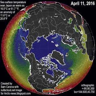
April 11, 2016: SST anomalies as high as 11.6°C or 20.8°F
In the Pacific, sea surface temperature anomalies from 1981-2011 were as high as 11.6°C or 20.8°F near Japan on April 11, 2016 (see image right), giving a further indication of the huge amount of additional heat that there now is in oceans on the Northern Hemisphere. The prospect is that temperatures will rise over the next few months to levels even higher than they were last year (see earlier post on temperatures in June 2015).

Sea ice acts as a buffer, absorbing heat and keeping the temperature of the water at freezing point. Without such a buffer, further heat will instead make that the temperature of the water will rise rapidly. Furthermore, less sea ice means that less sunlight gets reflected back into space and more sunlight instead gets absorbed by the Arctic Ocean.

These are just some of the many feedbacks that accelerate warming in the Arctic. Warm water reaching the seafloor of the Arctic Ocean can penetrate sediments that can contain huge amounts of methane in the form of hydrates and free gas, triggering abrupt release of methane in gigantic quantities, escalating into runaway warming, and subsequent destruction and extinction at massive scale.

On a 10-year timescale, the current global release of methane from all anthropogenic sources already exceeds all anthropogenic carbon dioxide emissions as agents of global warming; that is, methane emissions are more important than carbon dioxide emissions for driving the current rate of global warming.


Above image shows that growth in methane levels has been accelerating recently; a trendline points at a doubling of methane levels by the year 2040. Unlike carbon dioxide, methane's GWP does rise as more of it is released. Methane's lifetime can be extended to decades, in particular due to depletion of hydroxyl in the atmosphere.

The situation is dire and calls for comprehensive and effective action as described at the Climate Plan.

Albert Kallio comments: 
More could have been added from the last National Snow and Ice Data Center (NSIDC) Arctic sea ice report for March, the general outlook for massive sea ice loss because the near-all-time record low marine snow and ice cover is coinciding with near-all-time record low terrestrial snow cover. NSIDC forecast that due to dark surfaces being so high, this easily leads to loss of sea ice. In fact, 2016 situation is even worse that it was previous record loss 2012 when snow cover was much larger. Same in 2007 when the sea ice area was slighly smaller, there was much larger terrestrial snow cover. Furthermore, neither 2007 nor 2012 occurred during strong El Nino like 1998. El Nino 2015-2016 is the strongest ever, also accompanied by the very warm Indian Ocean, Atlantic Ocean, and Southern Ocean around Antarctica. At times Antarctic sea water temperatures were also high leading to second smallest Austral summer sea ice at one point. Sea ice area also around Antarctica has been smaller than average most of time, despite increased melt water and reduced salinity - due to high temperatures. All these additional factors should be added into your conclusions without forgetting to mention that the added heat in the earth system is ripping the Polar Vortex apart as the jet streams have started to blend into other irregular atmospheric wind patters. Note also the increased flow of sea ice through the Fram Strait due to lowered spatial viscosity of sea ice that also results from larger wave action, vertical mixing of ocean by wind, thinner sea ice breaking easier apart and collapsing into pack ice, as well as being mostly seasonal ice (containing trace amounts of salts that make the chemical bounds in ice crystals weaker and fragile and melting easier), May be you can update and rejoice on NSIDC's March 2016 report noting all the points therein..