This is the most important message ever posted.
Please share it widely and add your comments!
(click on share in the box underneath this post)
Please share it widely and add your comments!
(click on share in the box underneath this post)
A catastrophe of unimaginable proportions is unfolding. Life is disappearing from Earth and runaway heating could destroy all life. At 5°C heating, most life on Earth will have disappeared. When looking only at near-term human extinction, 3°C will likely suffice. Study after study is showing the severity of the threat, yet too many keep ignoring or denying it, at the peril of the world at large. Have a look at the following:
Crossing the 2°C guardrail
The image below shows two trends, a long-term trend (blue) and a short-term trend (red) that better reflects El Niño peaks.

The image confirms an earlier analysis that it could be 1.85°C (or 3.33°F) hotter in 2019 than in 1750.
June 2019 was the hottest June on record, it was 2.08°C (or 3.74°F) hotter than the annual global mean 1980-2015, which was partly due to seasonal variations, as the image below shows.

This gives an idea of how hot it will be mid 2019. July 2019 is on course to be hottest month on record, further highlighting the danger that a strengthening El Niño could cause a steep temperature rise soon.
Remember the 2015 Paris Agreement, when politicians pledged to act on the threat of climate change, including by “Holding the increase in the global average temperature to well below 2°C above pre-industrial levels . . . ”
The image at the top highlights the danger of a rapid temperature rise occurring soon and of the 2°C (or 3.6°F) guardrail getting crossed soon, i.e. in 2020 (the blue long-term trend, based on 1880-June2019 data), or in 2019 (red trend, based on 2011-June 2019 data). Moreover, the danger is that temperatures will not come down after crossing 2°C, but instead will continue in a steep rise toward 3°C.

We are already at about 2°C above pre-industrial
 In the image at the top, NASA data are adjusted, as discussed in an earlier post. Such adjustment is appropriate for a number of reasons.
 Firstly, NASA uses the period 1951-1980 as their default baseline. Most of the adjustment is due to the use of a 1750 baseline, which better reflects pre-industrial.
Furthermore, air temperatures over oceans and higher polar anomalies are more appropriate, as confirmed by a recent study that concludes that missing data have been responsible for an underestimation of global warming by 0.1°C, and as illustrated by the image on the right, from a recent study, which shows the difference between using surface air temperature globally (black line), versus when sea surface temperature are used for oceans (dark blue line) and in case of incomplete coverage (light blue line).
At a 3°C rise, humans will likely go extinct
The image at the top shows two trends, a long-term trend in blue and a short-term trend in red which follows variations such as El Niño more closely. The blue trend points at a 3°C (or 5.4°F) rise by 2026, while the red trends shows that a 3°C rise could eventuate as early as in 2020 in case of a persistently strengthening El Niño.
At a 3°C rise, humans will likely go extinct, as habitat for humans (and many other species) will disappear. Such a rise will cause a rapid decline of the snow and ice cover around the globe, in turn making that less sunlight gets reflected back into space. Associated changes are discussed in more detail at this page and this page, and include that the jet stream will further get out of shape, resulting in more extreme weather events such as droughts, heatwaves and firestorms. Changes to the jet stream will also contribute to a further strengthening of storms, which threatens to push large amounts of hot, salty water into the Arctic Ocean, triggering eruptions of more and more seafloor methane.
From a 4°C rise, Earth will have a moist-greenhouse scenario
As the temperature rise gains further momentum, runaway heating may well turn Earth into a lifeless planet. This danger was discussed in a 2013 post, warning that, at 4°C rise, Earth will enter a moist-greenhouse scenario and without anything stopping the rise, it will continue to eventually destroy the ozone layer and the ice caps, while the oceans would be evaporating into the atmosphere's upper stratosphere and eventually disappear into space.
 |
| [ from an earlier post ] |
At 5°C rise, most life on Earth will be extinct. A 2018 study by Strona & Bradshaw indicates that most life on Earth will disappear with a 5°C rise (see box on the right).
As the temperature keeps rising, chances are that all life on Earth will go extinct, as Earth would be left with no ozone layer to protect life from deadly UV-radiation. Furthermore, Earth would no longer have water, an essential building block of life. Soil moisture, ground water and water in oceans would evaporate and eventually disappear into space, as discussed in an earlier post.
There are several reasons why the temperature will keep rising well beyond a 5°C rise, as discussed below.
Could Earth go the same way as Venus?
At first glace, such a lifeless planet scenario may seem unlikely, as Earth did experience high temperatures before, but each time it did cool down again. While many species went extinct as a result of steep temperature rises, each time some species did survive the mass extinction events in the past.
This time, however, the situation is much more dire than during previous mass extinctions, and temperatures could keep rising, due to:
- Brighter Sun - The sun is now much brighter than it was in the past;
- No sequestration - The rapidity of the rise in greenhouse gases and of the associated temperature rise leaves species little or no time to adapt or move, and leaving no time for sequestration of carbon dioxide by plants and by deposits from other species, nor for formation of methane hydrates at the seafloor of oceans;
- No weathering - The rapidity of the rise also means that weathering doesn't have a chance to make a difference. Rapid heating is also dwarfing what weathering (and vegetation) can do to reduce carbon dioxide levels; and
- Methane - Due to the rapid temperature rise, there is also little or no time for methane to get decomposed. Methane levels will skyrocket, due to fires, due to decomposition of dying vegetation and due to releases from melting terrestrial permafrost and from the seafloor (see more on methane further below).

The methane threat
Our predicament
The predicament of this geological time is that methane in hydrates has been accumulating for a long time, especially in the Arctic, where there is little or no hydroxyl present in the atmosphere in the first place, while some 75% of the East Siberian Arctic Shelf (ESAS) is shallower than 50 m, as also discussed in this earlier post and this earlier post.
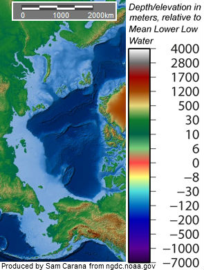
As more methane rises abruptly from the seafloor in plumes, the chance reduces that it will get decomposed in the water, and especially so in the Arctic where long uni-directional sea currents prevent microbes to return to the location of such plumes.
Shallow seas (light blue areas on the image on the right) make waters prone to warm up quickly during summer peaks, allowing heat to penetrate the seabed.
Methane rising through shallow waters will also enter the atmosphere more quickly. Elsewhere in the world, releases from hydrates underneath the seafloor will largely be oxidized by methanotroph bacteria in the water. In shallow waters, however, methane released from the seabed will quickly pass through the water column.
Large abrupt releases will also quickly deplete the oxygen in the water, making it harder for bacteria to break down the methane.
 |
| [ from an earlier post ] |
Hydroxyl depletion extending methane's lifetime
The graph on the right also shows that methane levels in the atmosphere remained almost unchanged during the period 2000-2007. One explanation for this is that, as the world heated up due to the rising levels of greenhouse gases in the atmosphere, the amount of water vapor in the atmosphere rose accordingly (at a rate of 7% for each degree Celsius rise), which translated into more hydroxyl getting produced that resulted in more methane getting decomposed. So, while methane emissions kept rising, the amount of methane in the atmosphere remained relatively stable, as more methane got decomposed. Eventually, in 2007, the continued rise in methane emissions started to overwhelm the capacity of hydroxyl to decompose methane.
The danger is that, as huge amounts of methane get released rapidly, hydroxyl depletion will extend its lifetime, in turn further accelerating heating and resulting in further releases of seafloor methane.
Methane's GWP
 Measured over a few years, methane's global warming potential (GWP) is very high. The image on the right, from IPCC AR5, shows that over a 10-year timescale, the current global release of methane from all anthropogenic sources exceeds all anthropogenic carbon dioxide emissions as agents of global warming; that is, methane emissions are more important than carbon dioxide emissions for driving the current rate of global warming.
The values for methane's GWP that are used in the image on the right are also used in the image below, which shows that over the first few years, methane's GWP is more than 150 times higher than carbon dioxide.

Above image is actually conservative, as the IPCC also gives higher values for methane's GWP in AR5, i.e. for fossil methane and when including climate change feedbacks, while there also is additional warming due to the carbon dioxide that results from methane's oxidation. Furthermore, research published in 2016 and 2018 found methane to be more potent than IPCC's GWP for methane in AR5, so it seems appropriate to use 150 as methane's GWP for periods of a few years.
Self-reinforcing feedback loops further accelerate heating in the Arctic and just one of them, seafloor methane, could suffice to cause runaway heating.
 |
| from an earlier post (2014) |

As described on above image and in an earlier post, a rapid temperature rise could result from a combination of elements, including albedo changes, loss of sulfate cooling, and methane released from destabilizing hydrates contained in sediments at the seafloor of oceans.
 |
| [ from an earlier post ] |
Seafloor methane releases could be triggered soon by strong winds causing an influx of warm, salty water into the Arctic ocean, as described in an earlier post and discussed in the 2017 video below. In the above images, methane is responsible for a temperature rise of as much as 1.1°C in a matter of years, but the rise won't stop there. A study published in 2012 calculates that 1000-fold methane increase could occur resulting in a rise of as much as 6°C within 80 years, with more to follow after that.
Youtube video by RT America
In the May 2019 video below, Professor Guy McPherson and Thom Hartmann discuss our predicament.
The situation is dire and calls for comprehensive and effective action, as described in the Climate Plan.
Links
• Extinction Alert
https://arctic-news.blogspot.com/2019/02/extinction-alert.html
• Geographical Distribution of Thermometers Gives the Appearance of Lower Historical Global Warming - by Rasmus Benestad et al.
https://agupubs.onlinelibrary.wiley.com/doi/full/10.1029/2019GL083474
• July on course to be hottest month ever, say climate scientists - The Guardian
https://www.theguardian.com/environment/2019/jul/16/july-on-course-to-be-hottest-month-ever-say-climate-scientists
• Radiative forcing of carbon dioxide, methane, and nitrous oxide: A significant revision of the methane radiative forcing - by Maryam Etminan et al. (2018)
https://agupubs.onlinelibrary.wiley.com/doi/full/10.1002/2016GL071930
• Large regional shortwave forcing by anthropogenic methane informed by Jovian observations - by William Collins et al. (2016)
https://advances.sciencemag.org/content/4/9/eaas9593
• Estimating and tracking the remaining carbon budget for stringent climate targets - by Joeri Rogelj et al.
https://www.nature.com/articles/s41586-019-1368-z
• As El Niño sets in, will global biodiversity collapse in 2019?
https://arctic-news.blogspot.com/2018/11/as-el-nino-sets-in-will-global-biodiversity-collapse-in-2019.html
• Methane hydrates
https://methane-hydrates.blogspot.com/2013/04/methane-hydrates.html
• Damage of Land Biosphere due to Intense Warming by 1000-Fold Rapid Increase in Atmospheric Methane: Estimation with a Climate–Carbon Cycle Model, by Atsushi Abata et al. (2012)
https://journals.ametsoc.org/doi/full/10.1175/JCLI-D-11-00533.1
• Extreme weather
https://arctic-news.blogspot.com/p/extreme-weather.html
• Feedbacks in the Arctic
https://arctic-news.blogspot.com/p/feedbacks.html
• Albedo and Latent Heat
https://arctic-news.blogspot.com/p/albedo.html
• Earth is on the edge of runaway warming
https://arctic-news.blogspot.com/2013/04/earth-is-on-the-edge-of-runaway-warming.html
• When Will We Die?
https://arctic-news.blogspot.com/2019/06/when-will-we-die.html
• Warning of mass extinction of species, including humans, within one decade
http://arctic-news.blogspot.com/2017/02/warning-of-mass-extinction-of-species-including-humans-within-one-decade.html
• Climate Plan
https://arctic-news.blogspot.com/p/climateplan.html


