Saturday, February 15, 2014

Extreme weather strikes around the globe - update

As the weather gets more extreme, disaster strikes around the globe. The Guardian reports three people killed as storms continue to batter southern UK. The Vancouver Sun reports that a U.S. Northeast snowstorm kills 25. And the Sacramento Bee reports Six dead and 1,000 injured in fresh Japan snow storm.

What is the story behind these extreme weather events? The image below tells the story. The Arctic has been much warmer than it used to be, due to numerous feedbacks that accelerate warming in the Arctic. This reduces the temperature differential between the Arctic and lower latitudes, which changes the Jet Stream and Polar Vortex, in turn making the weather at many places ever more extreme.

 earlier forecasts by cci-reanalyzer.org
Above image illustrates the situation, showing an Arctic Ocean that is warmer than the higher latitudes of the Asian and North American continents.

Arctic sea ice has meanwhile reached record lows, as illustrated by the image below.


The situation can be expected to get even worse. The image below shows sea ice extent, as measured by the NSIDC, which is one day ahead compared to above image.


Below, two regular contributors to the Arctic-news blog comment on the situation.

Monday, February 10, 2014

Extreme weather strikes around the globe

  Editorial note: this post has meanwhile been updated as
Extreme weather strikes around the globe update.


As the weather gets more extreme, disaster strikes around the globe.

Here's a snapsnot from today's news. In London, the BBC reports, flooded homes along the River Thames are being evacuated and thousands more are at risk. In Japan, reports Reuters, eleven people died, more than a thousand were injured and tens of thousands lost power when the worst snowstorm in decades hit Tokyo and areas around the Japanese capital before heading north to blanket the tsunami-hit Pacific coast. Many countries in the Middle East were hit by snow. The BBC reports that heavy snow in northern Iran has left around 480,000 homes without power and some towns and villages cut off.

What is causing these extreme weather events? The image below tells the story. While at times it has been cold at many places around the world, when averaged over the past 30 days, temperatures around the globe have actually been several degrees higher than they used to be. The Arctic has been hit hardest, with anomalies as high as 21°C over this 30 day period. This affects the Jet Stream and Polar Vortex, which in turn is making the weather ever more extreme.


The situation is further illustrated by the cci-reanalyzer.org forecasts below.


And while the sea ice didn't look too bad at the start of the year, growth has meanwhile stopped, as illustrated by the image below.


Added below are two videos by Paul Beckwith, further discussing the situation.


Editor's note: Reanalysis of temperature anomaly Jan 12 - Feb 10, 2014.
Meanwhile, I've added another image (above), created with NOAA's reanalysis, which compares temperatures to a larger dataset, and the colors look a lot different, so NOAA may indeed have mixed the colors up somewhat in the initial image, as Albert suggested at the Facebook discussion (click on image below).

Anyway, the point made in the post remains, i.e. that as global warming continues, warming in the Arctic accelerates more rapidly than at lower latitudes, which weakens the polar vortex and jet stream in a self-reinforcing feedback that causes the Arctic to warm up even further compared with lower latitudes.

As said, the situation calls for comprehensive and effective action, as discussed at the Climate Plan blog.

Sunday, February 9, 2014

High methane readings over Greenland

High methane readings have been recorded over Greenland since the start of February 2014. The image below shows methane readings of 1950 ppb and higher in yellow on February 9, 2014.


The animation below shows that high methane readings (1950+ ppb in yellow) have been showing up over Greenland since the start of February 2014.

[ Note: this animation is a 3.28 MB file that may take some time to fully load ]
What could have caused these high methane readings? The persistence with which the methane shows up over Greenland indicates that it did indeed originate from Greenland.

The above animation also illustrates that high methane readings show up every other image. The IASI readings come from a satellite that is orbiting the poles twice daily, with a 12-hour interval, so the satellite passes the North Pole twice every day. This makes that the images follow a day-versus night pattern, indicating that the high methane readings follow a circadian rhythm, suggesting a pattern that is in line with temperature differences between day and night.

There often is a difference in methane readings between day and night, but rarely is it as distinct as is currently the case over Greenland. And indeed, more is currently happening to temperatures over Greenland than mere differences in temperature between day and night.

As discussed in earlier posts such as this one, the once-common temperature difference between the Arctic and lower latitudes has been shattered, and this is weakening the Jet Stream and the Polar Vortex, in turn making it easier for cold air to flow down to lower latitudes and for warmer air to enter the Arctic. As a result, temperatures over Greenland can go from one extreme to another and back, as illustrated by the image with selected cci-reanalyzer.org forecasts below.

[ click on image to enlarge ]
Above image shows that, in some areas over Greenland, temperature anomalies may go down as low as as minus 20 degrees Celsius one day, then climb as high as 20 degrees Celsius a few days laters, to hit temperature anomalies as low as minus 20 degrees Celsius again some days later. These are swings of 40 degrees Celsius that can hit an area over the course of a few days. 

This could explain the methane over Greenland. Methane is present in the Greenland ice sheet in the form of hydrates and free gas. These huge temperature swings are causing the ice to expand and contract, thus causing difference in pressure as well as temperature. The combined shock of wide pressure and temperature differences is causing movement and fractures in the ice allowing methane to rise to the surface and enter the atmosphere.

The image below puts things in perspective, comparing methane over Greenland with methane over the Arctic Ocean.


Above image shows that the amounts of methane over Greenland are huge, while methane is still being released from the seafloor of the Arctic Ocean, in particular along the faultline that runs from the north of Greenland to the Laptev Sea. 

Few people seem to have anticipated these methane releases from the mountains of Greenland. Even worse, similar processes could be going at times on Antarctica, the Himalayas and the Qinghai-Tibet Plateau. I warned about this danger, e.g. in the May 2013 post Is Global Warming breaking up the Integrity of the Permafrost?. The danger that methane will be released in large (and growing) quantities from hydrates and free gas contained in the ice over mountains appears to have been ignored by the IPCC, which puts more weight on my estimate that methane release from hydrates currently amounts to 99 Tg annually, vastly more than the most recent IPCC estimates of 6 Tg per year. 

Without action on climate change, these methane releases threaten to rise even further and cause runaway global warming. This calls for comprehensive and effective action as discussed at the Climate Plan blog

Saturday, February 8, 2014

CO2 growth highest on record

Despite many promises, global emissions of carbon dioxide (CO2) continue to grow.

NOAA figures show that 2013 CO2 level growth was the highest ever recorded, i.e. 2.95 ppm.

The EPA expects U.S. 2013 energy-related CO2 emissions to be 2% higher than in 2012.

The UC San Diego image below shows CO2 levels in the atmosphere over the past two years.

Back in September 2013, John Davies warned: The world is probably at the start of a Runaway Greenhouse Event which will end most human life on Earth before 2040. This will occur because of a massive and rapid increase in the carbon dioxide concentration in the air which has just accelerated significantly. The increasing Greenhouse Gas concentration, the gases which cause Global Warming, will very soon cause a rapid warming of the global climate and a chaotic climate.

The post featured a graph with a 4th-order polynomial trendline pointing at some 7.5 ppm CO2 annual growth by 2040. While many welcomed the warning contained in the graph, some argued against using higher-order polynomial trendlines. So, for those who don't feel comfortable with a 4th-order polynomial trendline, the graph below adds both a linear trendline and a 3rd-order polynomial trendline.


The 3rd-order polynomial trendline, based on the recent data, points at CO2 annual growth of some 7 ppm by 2040, justifying the warning sounded by the 2013 graph.

And what do the recent data say, when a 4th-order polynomial trendline is applied? As the image below shows, they show an even steeper rise, reaching 7 ppm growth per year as early as 2030.


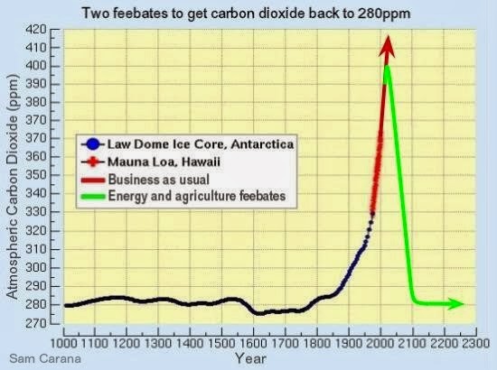
As many posts at this blog have warned, rapid growth in greenhouse gases and numerous feedbacks are threatening to push Earth into runaway global warming. This calls for comprehensive and effective action to - among other things - reduce atmospheric CO2 levels back to 280 ppm, as illustrated by the image below and as further discussed at the Climate Plan blog.


Tuesday, February 4, 2014

As continental U.S. freezes, Alaska gets record high temperatures

While much of the continental United States endured several cold snaps in January 2014, record-breaking warmth gripped Alaska. Spring-like conditions set rivers rising and avalanches tumbling. NASA Eartobservatory illustrates the above words with the two images below.


Above map depicts land surface temperature anomalies in Alaska for January 23–30, 2014. Based on data from the Moderate Resolution Imaging Spectroradiometer (MODIS) on NASA’s Terra satellite, the map shows how 2014 temperatures compared to the 2001–2010 average for the same week. Areas with warmer than average temperatures are shown in red; near-normal temperatures are white; and areas that were cooler than the base period are blue. Gray indicates oceans or areas where clouds blocked the satellite from collecting usable data.

A persistent ridge of high pressure off the Pacific Coast fueled the warm spell, shunting warm air and rainstorms to Alaska instead of California, where they normally end up. The last half of January was one of the warmest winter periods in Alaska’s history, with temperatures as much as 40°F (22°C) above normal on some days in the central and western portions of the state, according to Weather Underground’s Christopher Bart. The all-time warmest January temperature ever observed in Alaska was tied on January 27 when the temperature peaked at 62°F (16.7°C) at Port Alsworth. Numerous other locations—including Nome, Denali Park Headquarters, Palmer, Homer, Alyseka, Seward, Talkeetna, and Kotzebue—all set January records.

The combination of heat and rain has caused Alaska’s rivers to swell and brighten with sediment, creating satellite views reminiscent of spring and summer runoff. On January 25, 2014, the Aqua satellite collected this image of sediment flowing into the Gulf of Alaska from numerous rivers along the state’s southeastern coast.

All of the heat, moisture, and melting snow has elevated the risk of avalanches. A series of extremely large avalanches in late January sent snow and debris crashing onto the Richardson Highway, blocking the road and cutting the port town of Valdez off from highway access. The avalanches dumped a mound of snow 100 feet (30 meters) tall and up to 1,500 feet (460 meters) long on the highway.


Below are two videos with forecasts for the period from February 4, 2014, to February 11, 2014. The top video shows temperature forecasts and the bottom video shows temperature anomaly forecasts.

Saturday, February 1, 2014

Abrupt Climate Change - by Paul Beckwith

by Paul Beckwith

Humans have benefited greatly from a stable climate for the last 11,000 years - roughly 400 generations. Not anymore. We now face an angry climate. One that we have poked in the eye with our fossil fuel stick and awakened. Now we must deal with the consequences. We must set aside our differences and prepare for what we can no longer avoid. And that is massive disruption to our civilizations.

In a nutshell, the logical chain of events occurring is as follows:
  1. Greenhouse gases that humans are putting into the atmosphere from burning fossil fuels are trapping extra heat in the earth system (distributed between the oceans (93%), the cryosphere (glaciers, ice sheets, sea ice for 3%), the earth surface (rocks, vegetation, etc. for 3%) and the atmosphere (only an amazingly low 1%). The oceans clearly get the lions share of the energy, and if that 1% heating the atmosphere varies there can be decades of higher or lower warming, as we have seen recently. This water vapor rises and cools condensing into clouds and releasing its stored latent heat which is increasing storm intensity.
  2. (i)Rapidly declining Arctic sea ice (losing about 12% of volume per decade) and (ii)snow cover (losing about 22% of coverage in June per decade) and (iii)darkening of Greenland all cause more solar absorption on the surface and thus amplified Arctic warming (global temperatures have increased (on average) about 0.17oC per decade, the Arctic has increased > 1oC per decade, or about 6x faster)
  3. Equator-to-Arctic temperature difference is thus decreasing rapidly
  4. Less heat transfer occurs from equator to pole (via atmosphere, and thus jet streams become streakier and wavier and slower in west-to-east direction, and via ocean currents (like Gulf Stream, which slows and overruns continental shelf on Eastern seaboard of U.S.)
  5. Storms (guided by jet streams) are slower and sticking and with more water content are dumping huge torrential rain quantities on cities and widespread regions at higher latitudes than is “normal”.
  6. A relatively rare meteorological event called an “atmospheric river” is now much more common, and injects huge quantities of water over several days to specific regions, such as Banff (with water running downhill to Calgary) and Toronto and Colorado events.
The above is extracted from one of Paul's earlier posts.

Paul discusses more details in the videos below. Our abruptly changing climate system: where we are and where we are going.

Abrupt Climate Change - part 1


And the next part, Abrupt Climate Change - part 2


Extreme weather is like a sledgehammer repeatedly pounding away at the inaction, lethargy, and climate change denial that is prevalent in rich Western countries around the world.

Inevitably, the hammer pounding will increase in frequency, severity, duration, and spatial extent over the next few years until the denial crumbles, in spite of the annual one billion dollars in fossil fuel money that is paid to support fraud by hiding the truth on the threat that we all face. 

A tipping point in collective societal behaviour will occur, and humanity will finally initiate action, albeit frantically, to begin to deal with the largest problem ever faced in our history.


Paul Beckwith is a part-time professor with the laboratory for paleoclimatology and climatology, department of geography, University of Ottawa. He teaches second year climatology/meteorology. His PhD research topic is “Abrupt climate change in the past and present.” He holds an M.Sc. in laser physics and a B.Eng. in engineering physics and reached the rank of chess master in a previous life.

Thursday, January 30, 2014

Forecast: America to be hit by temperatures as low as minus 40 degrees

The image on the right shows that large parts of North America, the Arctic Ocean and Siberia are experiencing low temperatures.

What many people may not realize is that temperatures in the Arctic are actually a lot higher than they used to be around this time of year.

Temperatures in the Arctic have risen due to feedbacks as described in the post The Biggest Story of 2013.

As a result, temperature anomalies above 20 degrees Celsius now feature in the Arctic. As the image on the right illustrates, the once-common temperature difference between the Arctic and lower latitudes has been shattered, and this is weakening the Jet Stream and the Polar Vortex, in turn making it easier for cold air to flow down to lower latitudes and for warmer air to enter the Arctic, as described in posts at this blog for years, e.g. this post.

This is illustrated by the image below, showing that the Arctic is hit by an overall temperature anomaly of 6.55 degrees Celsius, while some areas in the Arctic feature anomalies above 20 degrees Celsius.


Forecasts show that on February 2nd, 2014, 1200 UTC, the Arctic will be hit by a temperature anomaly of 7.85 degrees Celsius, while on February 6th, 2014, 1200 UTC, the U.S. will be hit by temperatures as low as -40 degrees, as illustrated by the image below.


The video below shows temperature forecasts from February 1to February 8, 2014.


The video below shows temperatire anomalies from February 2 to February 9, 2014.


Meanwhile, the Gulf Stream keeps pushing warm water into the Arctic Ocean, as illustrated by the image below.

Click on image to enlarge - view updated animation at earth.nullschool.net 
The image below shows how high sea surface temperature anomalies stretch out from the point where the Gulf Stream travels at high speeds, off the coast of North America, all the way into the Arctic Ocean.


This has already resulted in methane eruptions from the seafloor of the Arctic Ocean that started several months ago and are continuing to date - ominous signs of more to come. The image below, which compares peak methane levels at two altitudes between January 2013 and January 2014, suggests that January 2014 peak levels have increased strongly, compared to January 2013 peak levels. Furthermore, that the rise in average peak readings has been most dramatic at the higher altitude.


This suggests that huge quantities of methane have indeed been released from hydrates under the Arctic ocean, and that much of the methane is rising and building up at higher altitudes. The increasing appearance of noctilucent clouds further confirms indications that methane concentrations are rising at higher altitudes.

Of course, the above analysis uses a limited dataset, but if verified by further analysis, it would confirm a dramatic rise in the presence of methane in the atmosphere due to releases from hydrates. Moreover, it would confirm the immensity of threat that releases from the Arctic Ocean will escalate and trigger runaway warming, as high methane concentrations over the Arctic are contributing to the anomalously high temperatures there. The risk that this will eventuate is unacceptable, which calls for comprehensive and effective action such as discussed at the ClimatePlan blog.