
The above image shows high temperature anomalies over the Arctic on June 3, 2023.

The above image shows sea surface temperature on the North Atlantic (0-60N, 0-80W) depicted as anomalies, reaching 1.04°C above 1982-2023 on June 8, 2023. The situation is especially critical in the North Atlantic, as vast amounts of ocean heat in the North Atlantic are moving toward the Arctic, threatening to cause rapid melting of Arctic sea ice and thawing of permafrost.


The above image shows the same data for sea surface temperature on the North Atlantic (0-60N, 0-80W) reaching 22.5°C on June 7, 2023 (on the black line), 0.6°C higher than the 21.9°C on June 7, 2022 (on the orange line).
The comparison with 2022 is important, as the North Atlantic sea surface temperature reached a record 24.9°C on Sept. 4, 2022, even while there was a strong La Niña, suppressing the temperature. This time, we have an El Niño, as illustrated by the NOAA image on the right.
 |
| [ click on images to enlarge ] |
The annual Arctic sea ice extent minimum is typically reached in September and the North Atlantic sea surface temperature is critical in regard to melting of the Arctic sea ice. The already high sea surface temperature together with the impact of the El Niño make the outlook for Arctic sea ice for September 2023 look grim.
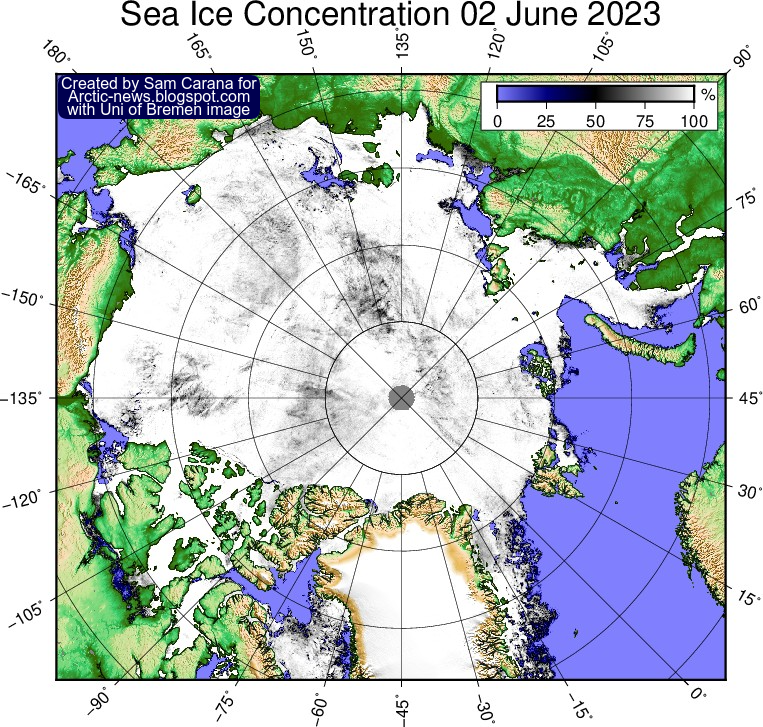
Sea ice concentration is getting lower in many places and there is open water in parts of the Beaufort Sea and Baffin Bay, as illustrated by the Uni of Bremen image on the right.
Rising temperatures in the Arctic threaten to trigger massive loss of Arctic sea ice over the coming months.

The image on the right, from polarportal.dk, shows very low Arctic sea ice volume for the time of year on June 8, 2023, already much lower than the volume on the same date for any of the four previous years.
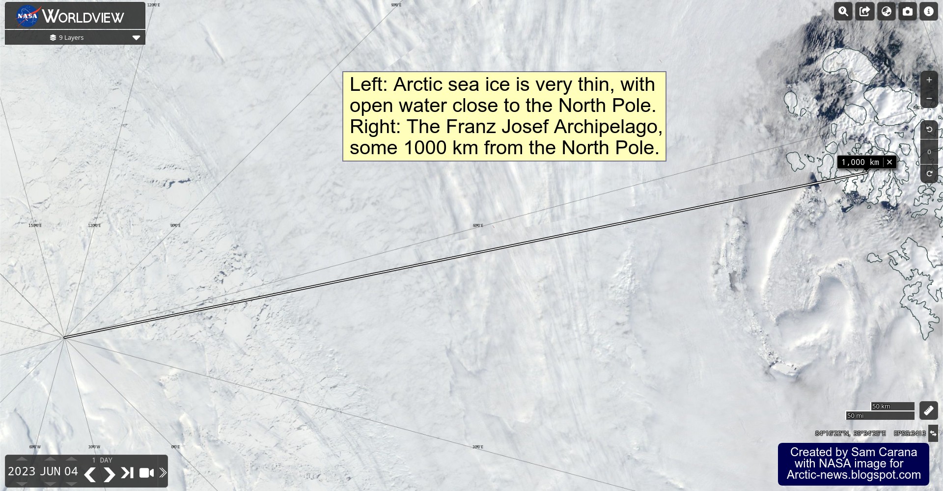
The NASA Worldview image below shows, on the left, that Arctic sea ice is very thin on June 4, 2023, with open water close to the North Pole.
On the right of the image below, the Franz Jozef Archipelago, some 1000 km from the North Pole.
The image below shows the situation on June 6, 2023.


The image on the right, from the Uni of Bremen, shows Arctic sea ice thickness on June 3, 2023.
On the one hand, it's terrible to see open water close to the North Pole so early in the year, yet on the other hand, this may enable ocean heat to escape to the atmosphere and thus delay eruption of seafloor methane (image below).
As discussed in earlier posts such as this one, conditions are dire:
• Earth's energy imbalance is at record high
• emissions are at record high
• greenhouse gas concentrations are at record high
• temperatures are very high, especially in the Arctic
• emissions are at record high
• greenhouse gas concentrations are at record high
• temperatures are very high, especially in the Arctic
• North Atlantic sea surface temperature is at record high
• sea ice is very vulnerable
• the Jet Stream is strongly deformed
• the Jet Stream is strongly deformed
The image below shows the extent of the deformation of the Jet Stream on June 6, 2023. No less than 26 circular wind patterns (at 250 hPa) are marked on the image, which also shows sea surface temperature anomalies. The Jet Stream is also crossing the Equator.

Furthermore, there are circumstances that could coincide in a cataclysmic alignment: El Niño is on the way, sunspots are higher than predicted and the Tonga submarine volcano did add large amounts of water vapor high into the atmosphere.
All this looks set to jointly result in massive loss of Arctic sea ice over the coming months, with loss of the latent heat buffer and loss of albedo threatening to trigger eruption of methane from the seafloor of the Arctic Ocean, as has been described many times before, such as in this post, in this post and in this post.
 |
| [ Latent heat loss, feedback #14 on the Feedbacks page ] |
 |
| [ see the Extinction page ] |
In addition, there are further events and developments that could unfold and make things even worse.
The bar on the right depicts the threat, as discussed at the Extinction page.
In conclusion, the situation is dire and calls for support for a Climate Emergency Declaration.
Links
https://climatereanalyzer.org/wx/todays-weather/?var_id=t2anom&ortho=1&wt=1
• Climate Reanalyzer - Daily sea surface temperatures
https://climatereanalyzer.org/clim/sst_daily
• NOAA - Climate Prediction Center - ENSO Diagnostic Discussions
https://www.cpc.ncep.noaa.gov/products/analysis_monitoring/enso_advisory/ensodisc.shtml
• University of Bremen - sea ice concentration and thickness
https://seaice.uni-bremen.de/start
• Polar Portal - Arctic sea ice thickness and volume
http://polarportal.dk/en/sea-ice-and-icebergs/sea-ice-thickness-and-volume
• NASA Worldview
https://worldview.earthdata.nasa.gov
• Wetland emission and atmospheric sink changes explain methane growth in 2020 - by Sushi Peng et al.
https://www.nature.com/articles/s41586-022-05447-w
• Will there be Arctic sea ice left in September 2023?
• Will there be Arctic sea ice left in September 2023?
• Climate Plan
https://arctic-news.blogspot.com/p/climateplan.html
• Climate Emergency Declaration
https://arctic-news.blogspot.com/p/climate-emergency-declaration.html