Thursday, May 21, 2015

Arctic Sea Ice At Historic Low

On May 20, 2015, Arctic sea ice extent was only 12.425 million square km, a record low for the time of the year since satellite measurements began in 1979.


As the Arctic Sea Ice is at a historic low, Alaska faces temperatures as high as 31°C (87.8°F), as illustrated by the image below.


How is it possible for temperatures to get so high at locations so close to the North Pole?

Typhoon Dolphin
Dr. Michael Ventrice, Operational Scientist at The Weather Channel Professional Division points at two typhoons, Noul and Dolphin, that recently hit the western Pacific Ocean.

These typhoons do have some impact. Importantly, global warming is increasing the strength of cyclones. In other words, a greater impact of cyclones on the jet stream can be expected as a feedback of global warming.

Furthermore, global warming is directly changing the path followed by the North Polar Jet Stream, from a relatively straight path at a latitude of 60°N to a wildly meandering path that at some places merges with the Subtropical Jet Stream and reaching speeds as high as 267 km/h (166 mph) and that at other places moves high into the Arctic and reaches speeds as high as 170 km/h (106 mph).


On above image, part of the jet stream even moves right across the pole. Such changes to the jet stream constitute one out of numerous feedbacks of global warming, as discussed at the feedbacks page. Decline of the snow cover and sea ice in the Arctic is another such feedback.

As discussed in earlier posts, heat waves at high latitudes cause thawing of frozen soil and melting of glaciers and snow cover, This results in large amounts of water draining into rivers that end up in the Arctic Ocean. At the same time, heat waves also raise the temperature of the water in these rivers. The larger amounts of warmer water result in additional sea ice decline and warming of the Arctic Ocean seabed.

Such heat waves also set the scene for wildfires that emit not only greenhouse gases such as carbon dioxide and methane, but also pollutants such as carbon monoxide (that depletes hydroxyl that could otherwise break down methane) and black carbon (that when settling on ice causes it to absorb more sunlight).


Above image shows how much warmer the water in the Arctic Ocean is compared to what it used to be, with high anomalies where rivers flow into the Arctic Ocean and where the Gulf Stream carries warm water from the Atlantic Ocean into the Arctic Ocean.

The situation looks set to get worse, as the frequency and intensity of heat waves in North America and Siberia increases as temperature at high latitudes are rising rapidly. Furthermore, warm water is lining up along the path of the Gulf Stream, with sea surface temperature anomalies as high as 10.3°C (18.54°F) recorded off the coast of North America on May 20, 2015, as illustrated by the image below.

Green circle shows a 10.3°C (18.54°F) sea surface temperature anomaly from daily average (1981-2011)

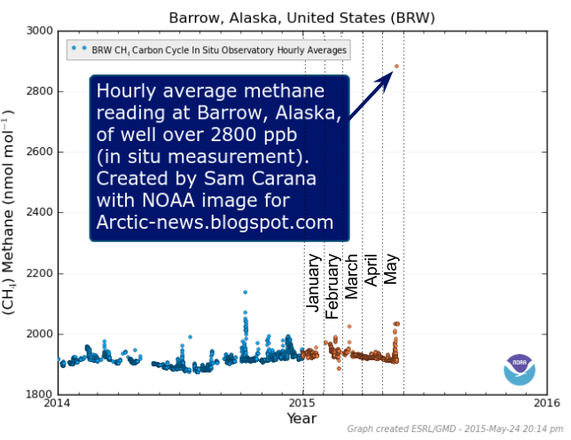
Meanwhile, a very high methane reading was recorded at Barrow, Alaska (hourly average, in situ measurement), as illustrated by the image below.


The big danger is that the combined impact of these feedbacks will accelerate warming in the Arctic to a point where huge amounts of methane will erupt abruptly from the seafloor of the Arctic Ocean.

The situation is dire and calls for comprehensive and effective action, as discussed at the Climate Plan page.


As the Arctic Sea Ice is at a historic low, Alaska faces temperatures as high as 31°C (87.8°F). From the post: Arctic...
Posted by Sam Carana on Thursday, May 21, 2015

Friday, May 15, 2015

Mackenzie River Warming

On May 12, 2015, a temperature of 80.1°F (or 26.7°C) was recorded in the north of Canada, at a location just north of latitude 63°N.


High temperatures in such locations are very worrying, for a number of reasons, including:
  • They are examples of heatwaves that can increasingly extend far to the north, all the way into the Arctic Ocean, speeding up warming of the Arctic Ocean seabed and threatening to unleash huge methane eruptions.  
  • They set the scene for wildfires that emit not only greenhouse gases such as carbon dioxide and methane, but also pollutants such as carbon monoxide (that depletes hydroxyl that could otherwise break down methane) and black carbon (that when settling on ice causes it to absorb more sunlight). 
  • They cause warming of the water of rivers that end up in the Arctic Ocean, thus resulting in additional sea ice decline and warming of the Arctic Ocean seabed. 
The image below shows increased sea surface temperature anomalies in the area of the Beaufort Sea where the Mackenzie River is flowing into the Arctic Ocean.


The image below further illustrates the situation, with sea ice thickness (in m) down to zero where the Mackenzie River flows into the Arctic Ocean.


Things look set to get worse. The forecast for May 16, 2015, shows high temperatures extending all the way to the coast where the Mackenzie River flows into the Arctic Ocean.


Updates follow below: 
Alaska is hit by high temperatures as well. The image below shows temperatures as high as 25.3°C (77.54°F) at a location just north of latitude 66°N in Alaska.


Below a forecast for May 23, 2015, showing temperatures in Alaska and neighboring parts of Canada that are 36°F (20°C) higher than they used to be (1979-2000 baseline).


The image below shows that temperatures as high as 30.2°C (86.36°F) are forecast for Alaska for May 23, 2015, along the path of the Yukon River, at a latitude of ~66 degrees North (65.98°N).

Furthermore, temperatures as high as 24.2°C (75.56°F) are forecast for the coast, close to where the Mackenzie River flows into the Arctic Ocean. Off the coast, over the water of the Arctic Ocean, temperatures as high as 8°C (46.4°F) are forecast, for a location just north of latitude 70°N, while temperatures as high as 15°C (59°F) are forecast for a location over the water of the Arctic Ocean closer to land.


As the image below illustrates, the jet stream is forecast to move across Alaska on May 23, 2015, bringing warm air into the atmosphere over the Arctic Ocean. The image gives the jet stream's speed at three locations, i.e. the jet stream is forecast to reach speeds as high as 262 km/h (162.8 mph, bottom green circle) over the Pacific Ocean, 165 km/h (102.5 mph, middle green circle) south of Alaska, and 172 km/h (106.9 mph, top green circle) over the Arctic Ocean.


Looking at salinity is a way to see the impact of rivers. The animation below, created with Naval Research Laboratory images over the period May 16 to 20, 2015 (run on May 18, 2015), shows salinity levels falling where the Mackenzie River flows into the Arctic Ocean.


Salinity works in several ways. Falling salinity will increase the temperature at which the sea ice melts. However, such an increase can only temporarily hold back melting, as illustrated by the combination image below, comparing sea ice thickness between May 7 and May 18, 2015.


Let's have a look at some of the feedbacks that haven't been discussed much in earlier posts. The potential for rivers to contribute to sea ice decline is depicted in the diagram below (feedback #24), i.e. extreme weather causing warming of rivers that flow into the Arctic Ocean. Furthermore, evaporation rates are higher over fresh water surfaces than over saline water surfaces (feedback #26) and the resulting increase in water vapor and clouds contributes to further warming (feedback #25), while rain falling on the sea ice will also cause its albedo to decline. The latter feedback also closes some loops. in that sea ice retreat results in more open water, in turn resulting in more water vapor and clouds.


Another feedback is that, as more sea ice turns into open water, less infrared radiation will be emitted and sent out into space, since open oceans are less efficient than sea ice when it comes to emitting in the far-infrared region of the spectrum (feedback #23). Furthermore, as sea ice declines, the increase in Arctic phytoplankton warms the ocean surface layer through direct biological heating (feedback #22).

For more discussion of these feedbacks, see the feedbacks page. In conclusion, the situation is dire and calls for comprehensive and effective action, as discussed at the Climate Plan page.

Forecast for May 16, 2015, showing high temperatures extending all the way to the coast where the Mackenzie River flows...
Posted by Sam Carana on Friday, May 15, 2015

Friday, May 8, 2015

Monthly CO2 Levels Above 400ppm


For the first time since modern records began, monthly mean carbon dioxide levels were above 400 parts per million (ppm), as illustrated by the NOAA image below. NOAA just released the mean global carbon dioxide level for March 2015, which was 400.83 ppm.
Arctic Ocean hit hard

Carbon dioxide concentrations can be especially high, i.e. well over 410 ppm, at higher latitudes of the Northern Hemisphere, as illustrated by the NOAA image below. This can contribute to very high temperature anomalies over the Arctic Ocean and thus increase the risk of huge amounts of methane erupting from the Arctic Ocean seafloor. 
Image contributed by Harold Hensel
Since the start of the Industrial Revolution, carbon dioxide levels have risen non-linearly, as illustrated by the image below.

Need for Comprehensive and Effective Action

As many posts at this blog have warned, emissions by people and the numerous feedbacks are threatening to push Earth into runaway global warming.

This calls for comprehensive and effective action to - among other things - reduce atmospheric carbon dioxide levels back to 280 ppm, as illustrated by the image below and as further discussed at the policies proposed as part of the Climate Plan.


How best to get back to 280 ppm? 

The Climate Plan calls for restoration of greenhouse gas levels in oceans and atmosphere to their long term average by 2100. In the Climate Plan, multiple lines of action are proposed to work simultaneously, in parallel and separately in their implementation, yet complementary in their impact.


One line of action is to cut emissions by 80% by the year 2020. To achieve this, the Climate Plan advocates implementation of local feebates. Especially important are fees on sales of fuel, while the resulting revenues are best used to fund rebates on products sold locally that further help speed up the shift to clean energy.

Without further action, much of the carbon dioxide that has been emitted will stay in the atmosphere for hundreds, if not thousands of years. Therefore, further lines of action are needed, including removal of carbon dioxide from the atmosphere and oceans, with the carbon being safely stored.

For the long term average of 280 ppm to be achieved in 2100, large amounts of atmospheric carbon dioxide must also be removed and safely stored annually. How much must be removed? The period from 2015 to 2100 has 85 years, so bringing down carbon dioxide from 400 ppm to 280 ppm over that period works out to an annual removal of 1.41 ppm. By comparison, this is slightly less than the annual growth in carbon dioxide levels as caused by people since 1959, which is on average 1.47 ppm. Assuming that emissions will not be cut quickly enough to avoid further build up of carbon dioxide in the atmosphere in the near future, annual removal will need to be somewhat more, so 1.47 ppm looks like a good target for now, precisely because it equals past emissions.

The Climate Plan thus proposes that each nation will contribute to the necessary annual 1.47 ppm removal with a share that reflects its past emissions. The image below gives an idea of past emissions. Note that the image only shows emissions up to the year 2011 and that they exclude land use change and forestry emissions. Furthermore, the image shows emissions based on where products were produced. Much of the rise in emissions is the result of products that were produced in Asia, yet many of these products were consumed in Europe and North America. Therefore, graphs based on emissions where products were consumed would paint a somewhat different picture. The Climate Plan proposes that a nation's contributions to carbon dioxide removal (from oceans and atmosphere) will reflect its past emissions based on where products were consumed.


The Climate Plan advocates separate lines of action, i.e. greenhouse gas removal next to emission cuts and further action. Keeping action on different types of pollution separate and calling for local action in each nation further helps avoid that progress elsewhere is pointed at by a nation as an excuse to delay the necessary action on a specific type of pollution in that nation.

As said, the Climate Plan therefore calls for fees to be added on sales of polluting products where they are consumed (as opposed to where they are produced). Each nation is further expected to take steps to contribute its share to the 1.47 ppm carbon dioxide that needs to be removed from the atmosphere annually. Additionally, carbon dioxide needs to be removed from the oceans.

The most important thing each nation can do in the lead-up to the upcoming U.N. climate conference in Paris is to accept these commitments. How each nation and local community does achieve targets is best decided locally, provided that each nation and each local community does indeed reach its targets, and this follows from this commitment.

One reason why local feebates are recommended is that they can focus on achieving local targets for a specific pollutant. Local feebates allow communities to quickly adjust the height of the fees, where a local community threatens to fail reaching a target. Such a local focus does not preclude action being beneficial elsewhere as well. Indeed, the same feebate can work for multiple pollutants and on multiple lines of action. In this sense, locally implemented feebates often work complementary. As an example, the feebates pictured below will help remove carbon dioxide from the atmosphere and oceans, while they will also help cut emissions of carbon dioxide, methane, soot and nitrous oxide.


Further background

- Climate Plan
http://arctic-news.blogspot.com/p/plan.html

- Feebates
http://feebates.blogspot.com/p/feebates.html

- Policies
http://arctic-news.blogspot.com/p/policies.html

- Action
http://arctic-news.blogspot.com/p/action.html


The Climate Plan calls for: - 80% emission cuts by 2020, for each type of pollutant, in each location and best managed...
Posted by Sam Carana on Saturday, May 9, 2015

Sunday, April 26, 2015

Methane levels as high as 2845ppb

Methane levels as high as 2845 parts per billion (ppb) were recorded on April 25, 2015, as illustrated by the image below.


This is an extremely high peak. The average daily peak in 2015 until May 1 was 2371 ppb, while the highest daily mean ranged from 1807 ppb (January 10) to 1829 ppb (April 22). Daily peaks and daily highest mean levels in 2015 are shown on the image below.


These peaks are much higher than they were in previous years, as illustrated by the image below, from an earlier post and showing the average highest peak readings in 2013 and 2014 at selected altitudes..


Peak readings in above image are averages over April 2013 and April 2014. On specific days, peak readings could be much higher, e.g. on April 28, 2014, methane levels were recorded as high as 2551 ppb at 469 mb. As said, methane levels as high as 2845 ppb were recorded on April 25, 2015, while the average peak for the first four months of 2015 was 2371 ppb, and this average was calculated from peaks across altitudes.

The table below shows the altitude equivalents in mb (millibar) and feet.
56,925 ft44,689 ft36,850 ft30,569 ft25,543 ft19,819 ft14,383 ft8,367 ft1,916 ft
74 mb147 mb218 mb293 mb367 mb469 mb586 mb742 mb945 mb

Peak levels in April appear to be rising strongly each year, following higher peak readings during previous months, especially at higher altitudes, i.e. especially the Arctic Ocean. It appears that much of the additional methane originating from the higher latitudes of the Northern Hemisphere has moved closer to the equator over the past few months, and is now accumulating at higher altitudes over the continents on the Northern Hemisphere, i.e. Asia, Europe, North America and north Africa.

Further analysis of the rise in global mean methane levels appears to confirm the above. The image below shows methane levels on April 22, over three years. While there appears to be little or no rise in mean methane levels at low altitudes, the rise is quite profound at higher altitudes.  

[ click on image to enlarge ]
Things look set to get worse. As shown by the image below, from an earlier post, global methane levels have risen sharply from a low of 723 ppb in 1755. Mean methane levels were as high as 1839 ppb in 2014. That's a rise of more than 254%.
As that post concluded a year ago, it appears that the rise of methane in the atmosphere is accelerating. What can we expect? As temperatures can be expected to continue to rise and as feedbacks start to kick in, this may well constitute a non-linear trend. The image below shows a polynomial trend that is contained in IPCC AR5 data from 1955 to 2011, pointing at methane reaching mean global levels higher than 3000 ppb by the year 2030. If methane starts to erupt in large quantities from clathrates underneath the seafloor of the Arctic Ocean, this may well be where we are heading. 


The situation is dire and calls for comprehensive and effective action, as discussed at the Climate Plan.


The 2845 ppb recorded on April 25, 2015, is an extremely high peak. The average daily peak in 2015 until now was 2372...
Posted by Sam Carana on Monday, April 27, 2015

Thursday, April 23, 2015

It's time to 'Do the math' again

By David Spratt

Have we gone mad? A new report released today explains why contemporary climate change policy-making should be characterised as increasingly delusional.

As the deadline approaches for submissions to the Australian government's climate targets process, there is a flurry of submissions and reports from advocacy groups and the Climate Change Authority.

Most of these reports are based on the twin propositions that two degrees Celsius (2°C) of global warming is an appropriate policy target, and that there is a significant carbon budget and an amount of "burnable carbon" for this target, and hence a scientifically-based escalating ladder of emission-reduction targets stretching to mid-century and beyond.

A survey of the relevant scientific literature by David Spratt, "Recount: It's time to 'Do the math' again", published today by Breakthrough concludes that the evidence does not support either of these propositions.

The catastrophic and irreversible consequences of 2°C of warming demand a strong risk-management approach, with a low rate of failure. We should not take risks with the climate that we would not take with civil infrastructure.

There is no carbon budget available if 2°C is considered a cap or upper boundary as per the Copenhagen Accord, rather than a hit-or-miss target which can be significantly exceeded; or if a low risk of exceeding 2°C is required; or if positive feedbacks such as permafrost and other carbon store losses are taken into account.

Effective policy making can only be based on recognising that climate change is already dangerous, and we have no carbon budget left to divide up. Big tipping-point events irreversible on human time scales such as in West Antarctica and large-scale positive feedbacks are already occurring at less than 1°C of warming. It is clear that 2°C of climate warming is not a safe cap.

In reality, 2°C is the boundary between dangerous and very dangerous climate change and 1°C warmer than human civilisation has ever experienced.

In the lead up to the forthcoming Paris talks, policy makers through their willful neglect of the evidence are in effect normalising a 2.5–3°C global warming target.

This evidence in "Recount: It's time to 'Do the math' again" demonstrates that action is necessary at a faster pace than most policy makers conceive is possible.


Related

- It's time to 'Do the math' again
http://www.climatecodered.org/2015/04/its-time-to-do-math-again.html

- RECOUNT - It's time to 'Do the math' again
http://media.wix.com/ugd/148cb0_938b5512abfa4d4e965ec8cc292893f7.pdf

- Two degrees of warming closer than you may think
http://arctic-news.blogspot.com/2015/02/two-degrees-of-warming-closer-than-you-may-think.html

- The real budgetary emergency and the myth of "burnable carbon"
http://arctic-news.blogspot.com/2014/05/the-real-budgetary-emergency-and-the-myth-of-burnable-carbon.html

It's time to 'Do the math' again | by David Spratt http://arctic-news.blogspot.com/2015/04/its-time-to-do-math-again.html

Posted by Sam Carana on Thursday, April 23, 2015

Saturday, April 18, 2015

The Great Unraveling


The great unraveling of how climate catastrophe is unfolding on land and in the oceans, in the atmosphere and the cryosphere, is becoming more and more clear every month.

March 2015 temperatures were the highest for March in the 136-year period of record. NOAA analysis shows that the average temperature across global land and ocean surface temperatures combined for March 2015 was 0.85°C (1.53°F) higher than the 20th century average of 12.7°C (54.9°F).

Ocean temperature anomalies on the Northern Hemisphere for March 2015 were the highest on record. In many ways, the situation looks set to get worse. For the 12-month period from April to March, data from 1880 contain a trendline that points at a rise of 2 degrees Celsius by the year 2032, as illustrated by the image below.

Click on image to enlarge
The rise in Northern Hemisphere ocean temperatures was especially profound in September and October 2014, when methane started to erupt from the Arctic Ocean seafloor in huge quantities.

The image below shows a polynomial trendline pointing at an October Northern Hemisphere sea surface temperature anomaly rise of 2°C (3.6°F) by 2030, and a rise of more than 5°C (9°F) by 2050, compared to the 20th century average, from an earlier post.
From: Ocean Temperature Rise continues
The images below give an idea of the current sea surface temperature anomalies around North America.


On April 11, 2015, a sea surface temperature of 22.2°C (71.96°F) was recorded off the North
American coast (green circle bottom), a 12.6°C (22.68°F) anomaly (green circle top).


Ocean heat is carried by the Gulf Stream from the North Atlantic into the Arctic Ocean. The huge amounts of energy entering the oceans translate into higher temperatures of the water and of the air over the water, as well as higher waves and stronger winds.

The image below highlights waves and winds, showing that waves as high as 12.06 m (39.57 ft) were recorded off the coast of North America in the path of the Gulf Stream, while winds with speeds as high as 115 km/h (71.46 mph) were recorded in that area on April 17, 2015.


The combination image below illustrates the threat. A sea surface temperature of 8°C (46.4°F, green circle left) was recorded near Svalbard on April 17, 2015, an anomaly of 6.2°C (11.16°F, green circle right).

Click on image to enlarge
A continued rise of ocean temperatures on the Northern Hemisphere threatens to unleash huge eruptions of methane from the seafloor of the Arctic Ocean, further accelerating the temperature rise in the Arctic and escalating into runaway global warming.

Malcolm Light comments: "The Pacific heating must be caused by the southward spreading Arctic methane global warming veil that is able to penetrate through a giant hole in the hydroxyl and ozone layer over the far east and is moving eastwards."

Current methane levels remain extremely high (see this recent post), on track to break the record mean level of 1839 ppb (parts per billion) reached in September 2014.


Above image shows that the highest mean methane levels ranged from 1815 ppb on March 30, 2015, to 1828 ppb on April 17, 2015. The highest peak level during this period was 2483 ppb, reached on April 15, 2015.

The extremely high methane levels are undoubtedly contributing to the high temperatures reached in March, especially at higher latitudes, on top of the dramatic global rise of greenhouse gases in general, as illustrated by above contribution by Peter Carter.


Above image shows that temperature anomalies over much of the Arctic Ocean were at the top end of the scale on April 17, 2015, i.e. 20°C or 36°F.

The image below gives an idea of the temperature differences on April 17, 215. While temperatures over the Sahara in Africa were as high as 32.1°C (89.78°F), temperatures over Greenland were as low as -41°C (-41.8°F). In between, temperatures of 2.8°C (37.04°) were recorded over the waters near Svalbard and of 6.1°C (42.98°F) closer to the coast of Norway.


Such wide temperature differences highlight the importance of looking at peaks, rather than at averages. The year-to-date maximum sea surface temperature anomaly, up to April 18, 2015, gives an idea of the peak anomalies that can be expected as the hot season approaches on the Northern Hemisphere.


Below are details for March 2015.


Temperature anomalies as high as 10.2°C (or 18.3°F) were recorded for March 2015 on Kolguyev Island in the Barents Sea.

A rise in ocean temperatures on the Northern Hemisphere of 2°C (3.6°F) by October 2030 looks set to go hand in hand with a 6°C (10.8°F) rise in Arctic temperatures by 2030, fueling runaway global warming, as illustrated by the image below, from another earlier post.

Without action, similar temperature rises look set to hit the globe at large a dozen years later, accompanied by huge temperature swings that threaten to cause depletion of supply of food and fresh water, as discussed by Guy McPherson in the video below and illustrated by the image further below.

Guy McPherson (left) in discussion with Paul Beckwith (right)

From Methane Levels Early 2015

In conclusion, the situation is dire and calls for comprehensive and effective action, as discussed at the Climate Plan blog.


Sources and Related

- Ocean temperatures, NOAA
http://www.ncdc.noaa.gov/sotc/global/2015/03

- Sea Surface Temperatures, from:
http://earth.nullschool.net
and from:
http://polar.ncep.noaa.gov/sst/ophi

- Kolguyev Island temperature anomaly, from:
http://data.giss.nasa.gov/tmp/gistemp/NMAPS/tmp_GHCN_GISS_ERSST_250km_Anom03_2015_2015_1951_1980/nmaps.txt

- Temperature anomaly April 17, 2015, Climate Reanalyzer
http://cci-reanalyzer.org

- Year-to-date maximum sea surface temperature anomaly April 18, 2015, from:
http://coralreefwatch.noaa.gov/satellite/bleaching5km/index_composites_5km.php

- Methane levels. NOAA IASI MetOp
http://www.ospo.noaa.gov/Products/atmosphere/soundings/iasi

- The Mechanism
http://arctic-news.blogspot.com/2015/02/the-mechanism.html

- Three kinds of warming (temperature trendlines), from: Methane levels Early 2015
http://arctic-news.blogspot.com/2015/03/methane-levels-early-2015.html

- Northern Hemisphere October Ocean Temperature Rise, from:
http://arctic-news.blogspot.com/2014/11/ocean-temperature-rise-continues.html


Ocean temperature anomalies on the Northern Hemisphere for March 2015 were the highest on record. In many ways, the...
Posted by Sam Carana on Saturday, April 18, 2015

Saturday, April 11, 2015

Arctic Sea Ice At Record Low On April 9 2015

On April 9, 2015, Arctic sea ice extent was only 14.051 square km, a record low for the time of the year, as illustrated by the image below.

Temperature anomalies at the top end of the scale (20°C, or 36°F) are hitting the Arctic Ocean in many places, as illustrated by the forecast below, showing an overall anomaly of +3.19°C for the Arctic for April 11, 2015, despite low temperatures over Greenland.


The situation is very worrying, the more so since a huge amount of ocean heat is lining up to be carried into the Arctic Ocean by the Gulf Stream. On April 10, 2015, sea surface temperatures of 24.1°C were recorded off the North American coast (green circle), a +12.5°C anomaly, as the image below shows.


Malcolm Light commentsIn this inverted blowup of the high temperature region you can see the expanded effect of methane hydrate detabilization along the Gakkel Ridge and the high temperatures caused by the onshore methane eruption vents (image below).


The situation is dire and calls for comprehensive and effective action, as discussed at the Climate Plan blog.


On April 9, 2015, Arctic sea ice extent was only 14.051 square km, a record low for the time of the year. From the post ...

Posted by Sam Carana on Saturday, April 11, 2015