Showing posts with label albedo. Show all posts

Friday, August 24, 2018

The once-thickest Arctic sea ice has gone

The image below shows Arctic sea ice north of Greenland and around Ellesmere Island. This is the area where for thousands of years the sea ice has been the thickest, in many places remaining thicker than 5 meters (16.4 ft) throughout the year.

[ The once-thickest sea ice has gone - click on images to enlarge ]
The image is a compilation of NASA Worldview images over seven days, from August 14 through to August 21, 2018. The least cloudy areas have been selected from each image to get the best insight in the magnitude of this catastrophe.

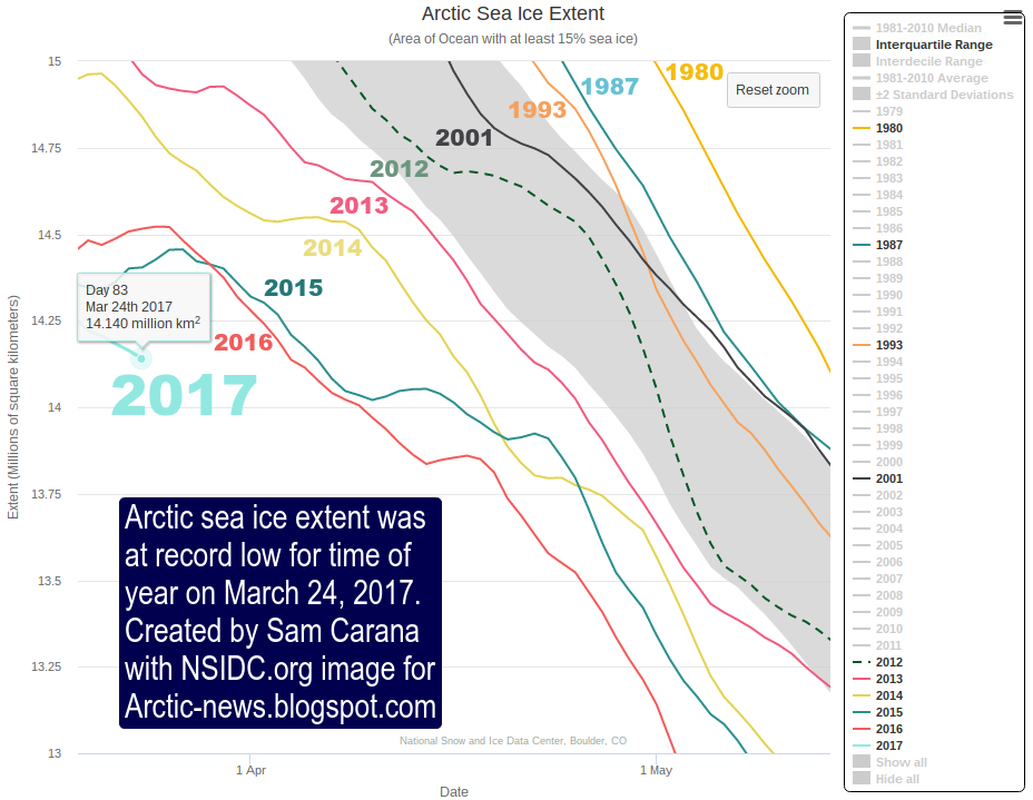
The loss of this sea ice indicates that the buffer is gone. Sea ice acts as a buffer that absorbs heat, while keeping the temperature at the freezing point of water, about zero degrees Celsius. As long as there is sea ice in the water, this sea ice will keep absorbing heat, so the temperature doesn't rise at the sea surface.

Once the buffer is gone, further energy that enters the Arctic Ocean will go into heating up the water. The amount of energy absorbed by melting ice is as much as it takes to heat an equivalent mass of water from zero to 80°C.

[ The Latent Heat Buffer has gone, feedback #14 on the Feedbacks page ]
At the same time, decline of the snow and ice cover in the Arctic causes more sunlight to get reflected back into space, resulting in more energy getting absorbed in the Arctic Ocean.

[ Albedo Change, feedback #1 on the Feedbacks page ]

Numerous feedbacks are associated with sea ice loss. As the temperature difference between the Arctic and the Equator decreases, changes are taking pace to the Jet Stream that in turn trigger a multitude of further feedbacks, such as more extreme weather and a more scope for heat to enter the Arctic Ocean (see feedbacks page).


A further huge danger is that, as warming of the Arctic Ocean continues, heat will reach methane hydrates at the seafloor of the Arctic Ocean, causing them to get destabilized and release methane.

[ Seafloor methane, feedback #2 on the Feedbacks page ]
Adding up all warming elements associated with disappearance of the sea ice could result in additional global warming many times as much as the current global warming, all in a few years time.

Meanwhile, for the first time in human history, mean global methane levels as high as 1900 ppb have been recorded. The measurements were recorded by the MetOp-1 satellite on the morning of August 22, 2018, at 280 mb, 266 mb, 307 mb and 321 mb, as shown by the images below.


At 293 mb, MetOp-1 recorded an even higher level, i.e. mean global methane level was 1901 ppb on the morning of August 22, 2018.


The situation is dire and calls for comprehensive and effective action, as described in the Climate Plan.


Links

• It could be unbearably hot in many places within a few years time
https://arctic-news.blogspot.com/2016/07/it-could-be-unbearably-hot-in-many-places-within-a-few-years-time.html

• Feedbacks
https://arctic-news.blogspot.com/p/feedbacks.html

• Latent Heat
https://arctic-news.blogspot.com/p/latent-heat.html

• Albedo and more
https://arctic-news.blogspot.com/p/albedo.html

• How much warming have humans caused?
https://arctic-news.blogspot.com/2016/05/how-much-warming-have-humans-caused.html

• The Threat
https://arctic-news.blogspot.com/p/threat.html

• Extinction
https://arctic-news.blogspot.com/p/extinction.html

• Climate Plan
https://arctic-news.blogspot.com/p/climateplan.html


Friday, July 13, 2018

Disappearance of Arctic Sea Ice

The image on the right shows sea surface temperatures on July 6 for the years 2014 to 2018 at a location near Svalbard (at 77.958°N, 5.545°E), with an exponential trend added based on the data.

The combination image below shows sea surface temperatures on July 6 for each of these years, with the location highlighted by a green circle:
2014:  -0.8°C or 30.6°F
2015:   6.2°C or 43.2°F
2016:   8.3°C or 47.0°F
2017: 14.4°C or 57.9°F
2018: 16.6°C or 61.9°F

The situation reflects the rapid decline of Arctic sea ice over the years and constitutes a stark warning of imminent sea ice collapse and its consequences for the world at large.

[ click on images to enlarge ]
The image on the right shows the sea surface temperature on July 18, 2018, at that location. It was as warm as 17.2°C or 63°F near Svalbard. This compares to a sea surface temperature of 5°C or 41.1°F in 1981-2011 at that location (at the green circle). For more background on the warm water near Svalbard, also see the earlier post Accelerating Warming of the Arctic Ocean.

The images illustrate why sea ice has fallen dramatically in volume, especially so where sea currents push warm water from the Atlantic Ocean underneath the sea ice.

The decline of Arctic sea ice volume over the years is illustrated by the Jim Pettit graph below.

As the Wipneus image below shows, Arctic sea ice volume on July 9, 2018, was at a record low for the time of the year.


The animation on the right shows a fall in volume of some 1 meter over most of the sea ice, over the period from June 21 through July 12, 2018, with a further eight days of forecasts added.

The animation illustrates the huge amount of melting taking place from underneath, due to an inflow of heat from the Atlantic Ocean and the Pacific Ocean, and from warm water from rivers that end in the Arctic Ocean. Meanwhile, sea ice extent doesn't fall very much at all.

When only looking at sea ice extent, the dramatic fall in sea ice volume may be overlooked.

Complete disappearance of Arctic sea ice in September 2018 is within the margins of a trend based on yearly annual minimum volume, as illustrated by the image on the right.

Latent heat can make such disappearance come abruptly and - for people who only look at changes in extent - rather unexpectedly.

Latent heat is energy associated with a phase change, such as the energy absorbed by solid ice when it changes into water (melting). During a phase change, the temperature remains constant.

Sea ice acts as a buffer that absorbs heat, while keeping the temperature at zero degrees Celsius. As long as there is sea ice in the water, this sea ice will keep absorbing heat, so the temperature doesn't rise at the sea surface.

The amount of energy absorbed by melting ice is as much as it takes to heat an equivalent mass of water from zero to 80°C.


Oceans take up over 90% of global warming, as illustrated by the image below. Ocean currents make that huge amounts of this heat keep entering the Arctic Ocean from the Pacific Ocean and the Atlantic Ocean.


Once the sea ice is gone, further ocean heat must go elsewhere, i.e. it will typically raise the temperature of the water. The atmosphere will also warm up faster. More evaporation will also occur once the sea ice is gone, which will cool the sea surface and warm up the atmosphere (technically know as latent heat of vaporization).

As temperatures in the Arctic are rising faster than at the Equator, the Jet Stream will change, making it easier for warm air to enter the Arctic. More clouds will form over the Arctic, which will reflect more sunlight into space, but which will also make that less outward IR radiation can escape into space over the Arctic, with a net warming effect.

Meanwhile, El Niño is getting stronger, as illustrated by above image on the right. A warmer Arctic comes with stronger heat waves, forest fires and associated emissions, and rapid warming of water in rivers that end in the Arctic Ocean, all of which will further warm up the Arctic Ocean. Forest fires have already been burning strongly in Siberia over the past few months and methane recently reached levels as high as 2817 ppb (on July 8, 2018, pm).

One huge danger is that, as the buffer disappears that until now has consumed huge amounts of ocean heat, and the Arctic Ocean keeps warming, further heat will reach methane hydrates at the seafloor of the Arctic Ocean, causing them to get destabilized and release methane.

[ The Buffer has gone, feedback #14 on the Feedbacks page ]
Additionally, disappearance of the sea ice will come with albedo changes that mean that a lot more sunlight will be absorbed, instead of getting reflected back into space as occurred previously.


Similar albedo changes are likely to take place over land in the Arctic soon thereafter. Adding up all warming elements associated with disappearance of the sea ice can result in an additional global warming of several degrees Celsius.

The situation is dire and calls for comprehensive and effective action, as described in the Climate Plan.


Links

• Can we weather the Danger Zone?
https://arctic-news.blogspot.com/2018/07/can-we-weather-the-danger-zone.html

• How much warmer is it now?
https://arctic-news.blogspot.com/2018/04/how-much-warmer-is-it-now.html

• Accelerating Warming of the Arctic Ocean
https://arctic-news.blogspot.com/2016/12/accelerating-warming-of-the-arctic-ocean.html

• High Temperatures Over Arctic Ocean In June 2018
https://arctic-news.blogspot.com/2018/06/high-temperatures-over-arctic-ocean-in-june-2018.html

• Feedbacks
https://arctic-news.blogspot.com/p/feedbacks.html

• Latent Heat
https://arctic-news.blogspot.com/p/latent-heat.html

• How much warming have humans caused?
https://arctic-news.blogspot.com/2016/05/how-much-warming-have-humans-caused.html

• The Threat
https://arctic-news.blogspot.com/p/threat.html

• Extinction
https://arctic-news.blogspot.com/p/extinction.html

• Climate Plan
https://arctic-news.blogspot.com/p/climateplan.html


Monday, March 27, 2017

Earth losing her sea ice

Earth is losing her sea ice. Arctic sea ice was at record low extent for the time of the year on March 24, 2017, as illustrated by the image below.


As the image below shows, on March 24, 2017, Arctic sea ice featured many cracks (top of Greenland is bottom left and Svalbard is on the right).


The poor state of Arctic sea ice is also reflected by the sea ice volume, as depicted by the image below, by Wipneus, showing PIOMAS anomalies up to March 2017.

On March 24, 2017, Antarctic sea ice extent was also much lower than it used to be at this time of year, as illustrated by the image below.


Altogether, global sea ice extent has now been at a record low for many months, as illustrated by the graph by Wipneus below. This means that a huge amount of additional sunlight has been absorbed over these months, instead of getting reflected back into space as before.


As Earth loses her sea ice, tipping point look set to be crossed that could result in rapid acceleration of Earth's temperature, as discussed at the extinction page, which warns that surface temperatures of the atmosphere could rise by some 10°C or 18°F within a decade, i.e. by 2026.

The situation is dire and calls for comprehensive and effective action, as described in the Climate Plan.


Links

• Climate Plan
http://arctic-news.blogspot.com/p/climateplan.html

• Extinction
http://arctic-news.blogspot.com/p/extinction.html

• How much warming have humans caused?
http://arctic-news.blogspot.com/2016/05/how-much-warming-have-humans-caused.html

• Warning of mass extinction of species, including humans, within one decade
http://arctic-news.blogspot.com/2017/02/warning-of-mass-extinction-of-species-including-humans-within-one-decade.html


Saturday, March 4, 2017

Low sea ice extent contributes to high methane levels at both poles

[ click on images to enlarge ]
On March 2, 2017, Antarctic sea ice extent was at a record low since satellite readings started.

As the image on the right shows, sea ice extent in 2017 (light blue) around Antarctica has been more than 1 million km² lower than the 1981-2010 median.

At the same time, Arctic sea ice extent was at a record low for the time of the year since 1979.

As the image underneath on the right shows, Arctic sea ice extent in 2017 has also been more than than 1 million km² lower than the 1981-2010 median.

[ click on images to enlarge ]
For about half a year now, global sea ice extent has been more than 2 million km² lower than it used to be, not too long ago, as illustrated by the image below, by Wipneus.

This means that a lot of sunlight that was previously reflected back into space, has been absorbed instead by Earth, contributing to global warming, especially at the poles.

Greater warming at the poles has also caused more extreme weather, resulting in stronger winds and waves and in wild weather swings, further accelerating the decline of the sea ice.

The combination of rising ocean heat and stronger winds looks set to devastate the sea ice around Antarctica. Ocean heat is increasing particularly in the top layer (see image on the right).

Warming water is increasingly reaching the coast of Antarctica. The image below illustrates how much sea ice melt has occurred close to the coast of Antarctic over the past few months, while much sea ice has drifted away from the coast due to strong currents and wind.


As said, less sea ice means that a lot of sunlight is no longer reflected back into space, but is instead further warming up the poles. As a result, methane levels can be very high at both poles. The combination image below shows methane levels as high as 2560 ppb on March 1, 2017. The image in the panel on the left shows high methane levels over Antarctica in an area with much grey, indicating that it was hard to get a good reading there. On the image in the panel on the right, high methane levels do show up clearly in that area.

[ click on images to enlarge ]
As discussed before, methane hydrates can be present both on Greenland and on Antarctica underneath thick layers of snow and ice. Due to global warming, wild weather swings are now common at the poles, as illustrated by the image below. This can cause sequences of rapid and extreme expansion, compacting and fracturing of snow and ice, resulting in destabilization of methane hydrates contained in the permafrost.


The image below shows methane levels as high as 2562 ppb, with solid magenta-colored areas showing up over the Laptev Sea on March 4, 2017.

The image below shows that sea surface temperatures in the Arctic Ocean were as high as 12.7°C or 54.9°F on March 3, 2017 (at the location marked by the green circle), i.e. 12°C or 21.6°F warmer than in 1981-2011.


Below is the same image, but in a different projection and showing sea surface temperatures, rather than anomalies. In 1981-2011, the temperature of the water at a spot near Svalbard (green circle) was 0.7°C (33.3°F.). On March 3, 2017, it was 12°C (21.6°F) warmer on that spot.


The danger is that self-reinforcing feedback loops such as albedo decline and methane releases will further accelerate warming and will, in combination with further warming elements, cause a temperature rise as high as 10°C or 18°F by the year 2026, as described at the extinction page.

The situation is dire and calls for comprehensive and effective action as described in the Climate Plan.


Links

• Climate Plan
http://arctic-news.blogspot.com/p/climateplan.html

• Extinction
http://arctic-news.blogspot.com/p/extinction.html

• Methane hydrates
http://methane-hydrates.blogspot.com/2013/04/methane-hydrates.html

• Earthquakes in the Arctic Ocean
http://arctic-news.blogspot.com/2014/04/earthquakes-in-the-arctic-ocean.html


Wednesday, February 15, 2017

More heat on the way


Above image shows temperature anomalies over the Pacific Ocean on February 12, 2017. Note the 19.2°C (34.5 °F) anomaly off the coast of Japan, at the location marked by the green circle.

In 2016, the annually-averaged temperature for ocean surfaces around the world was 0.75°C (1.35°F) higher than the 20th century average, higher than the previous record of 2015, NOAA reports. The global annual land surface temperature for 2016 was 1.43°C (2.57°F) above the 20th century average, surpassing the previous record of 2015 by 0.11°C (0.19°F). Note that NOAA uses the the 20th century average as a baseline, for more on different baselines, see this earlier post.

There is more heat on the way, as illustrated by the image below.


As above image shows, the El Niño-Southern Oscillation (ENSO) temporarily raises (El Niño) or suppresses (La Niña) global temperatures. Generally, the stronger the event (El Niño or La Niña), the greater its impact on the average global temperature around that time. Note that one value for 2016 literally went off the chart.


As above image shows (at the end of the graph on the right), we've barely had a bit of a La Niña in 2017 and we're already facing another El Niño event.

[ click on images to enlarge ]

Above images shows ECMWF (European Centre for Medium-Range Weather Forecasts) plumes with strong positive anomalies in all three El Niño regions (on the right).

In other words, temperatures in 2017 look set to be very high, which spells bad news for the Arctic where temperature anomalies are already several times higher than in the rest of the world, as illustrated by the image below.

As the image below shows, Antarctic sea ice extent was at a record low for the time of the year on February 11, 2017.


The situation looks particularly grim for the Arctic sea ice. As the image below shows, Arctic sea ice extent on February 11, 2017, was also at a record low for the time of the year. In fact, it had fallen to 13,895,00 km² that day, raising the question whether perhaps the maximum for the year 2017 had already been reached.


Low global sea ice extent means that less sunlight is reflected back into space by the ice and that more heat is instead absorbed by the ocean, adding to the predicament the world is in. The situation in the Arctic is crucial, as huge amounts of methane, contained in sediments under the Arctic Ocean, could be released if warming continues, potentially triggering mass extinction of species, including humans, within one decade.

The situation is dire and calls for comprehensive and effective action as described in the Climate Plan.


Links


• Climate Plan
http://arctic-news.blogspot.com/p/climateplan.html

• Extinction
http://arctic-news.blogspot.com/p/extinction.html

• How much warming have humans caused?
http://arctic-news.blogspot.com/2016/05/how-much-warming-have-humans-caused.html

• Warning of mass extinction of species, including humans, within one decade
http://arctic-news.blogspot.com/2017/02/warning-of-mass-extinction-of-species-including-humans-within-one-decade.html


Sunday, November 20, 2016

Sea ice is shrinking


Arctic sea ice extent fell 0.16 million km² from November 16 to November 19, 2016, as illustrated by above ads.nipr.ac.jp/vishop image. The image below, based on NSIDC data, shows the Arctic sea ice shrinking 49,000 km² in four days.


This is happening at a time when there is little or no sunlight reaching the Arctic, as illustrated by the image below.


The image below was created by Torstein Viddal and earlier posted at the Arctic Sea Ice Collapse blog.


This recent fall in extent is partly due to strong winds, as illustrated by the image on the right.

Mostly, though, the lack of sea ice over the Arctic Ocean is caused by very warm water that is now arriving in the Arctic Ocean.

During the northern summer, water off the coast of North America warms up and gets pushed by the Coriolis force toward the Arctic Ocean. It takes several months for the water to travel along the Gulf Stream through the North Atlantic.

It has taken until now for the Arctic Ocean to bear the brunt of this heat.

As the image below shows, record sea surface anomalies showed up near Svalbard on October 31, 2016, when this heat first arrived in the Arctic.


On October 31, 2016, the Arctic Ocean was as warm as 17°C or 62.7°F (green circle near Svalbard), or 13.9°C or 25°F warmer than 1981-2011. This indicates how much warmer the water is beneath the surface, as it arrives in the Arctic Ocean from the Atlantic Ocean.

Moreover, Antarctic sea ice is also falling, reflecting the warming of oceans globally. For some time now, Antarctic sea ice extent has been at a record low for the time of the year.  On November 19, 2016, the combined extent of Arctic and Antarctic sea ice was 22.423 million km², as the image below shows.


This constitutes a fall in global sea ice extent of 1.085 million km² (418,900 square miles) since November 12, 2016, when global sea ice extent was 23.508 million km².

Let's look at those figures again. On Saturday November 12, 2016, global sea ice extent was 23.508 million km². On Saturday November 19, 2016, global sea ice extent was 22.423 million km². That's a fall of more than one million km² in one week.

By comparison, that's more than the combined size of ten European nations (such as Switzerland, Austria, Hungary, Germany, Denmark, the Netherlands, Belgium, Luxembourg, the United Kingdom and Ireland).

Or, it's more than the combined size of seventeen States of the United States (such as Ohio, Virginia, Tennessee, Kentucky, Indiana, Maine, South Carolina, West Virginia, Maryland, Hawaii, Massachusetts, Vermont, New Hampshire, New Jersey, Connecticut, Delaware and Rhode Island).

How much additional energy does Earth retain, due to such an albedo change? If it was a total albedo flip, it would be some 0.68 W/m². A conservative estimate would be a 50% albedo flip, as the image below illustrates, so this would mean that Earth now retains some 0.34 W/m² extra energy.

Thick sea ice covered with snow can reflect as much as 90% of the incoming solar radiation. After the snow begins to melt, and because shallow melt ponds have an albedo (or reflectivity) of approximately 0.2 to 0.4, the surface albedo drops to about 0.75. As melt ponds grow and deepen, the surface albedo can drop to 0.15, while the ocean reflects only 6% of the incoming solar radiation and absorbs the rest.


So, this one-week fall in sea ice extent means there now is an additional warming of some 0.34 W/m². By comparison, the warming impact relative to the year 1750 of all carbon dioxide emitted by people was 1.68 W/m² in the most recent IPCC assessment report (AR5).

There's more! As sea ice declines, there is not only albedo loss due to a fall in extent, but there is also albedo loss over the remaining sea ice, which turns darker as it melts.

The image below shows the fall in extent of Antarctic sea ice up to November 20, 2016. On November 20, 2016, Antarctic sea ice extent was 2.523 million km² less than its extent was at the same time of the year in 2015.


How much more energy is now retained by Earth than in 2015? Assuming a 50% albedo flip for this extent loss and a similar albedo loss that's taking place over the remaining ice, this means that Earth is now retaining an extra amount of energy (compared to 2015) that is equal to all the warming relative to pre-industrial due to carbon dioxide emitted by people.

Above image shows how the difference between 2016 and 2015 Antarctic sea ice extent grew between November 4 and November 23. On November 23, 2016, Antarctic sea ice extent was 2.615 million km² smaller than on November 23, 2015.

That means that a huge amount of sunlight is now absorbed by the ocean, rather than reflected back into space.

The animation on the right (added later) shows the decline of the sea ice around Antarctica over the period from November 16, 2016, to January 4, 2017. For comparison, the blue line shows the 1979-2000 average.

The situation is dire and calls for comprehensive and effective action as described in the Climate Plan.