Showing posts with label Paris Agreement. Show all posts

Saturday, August 10, 2024

Paris Agreement thresholds crossed

High temperatures persist

The image below, created with NASA data while using a 1903-1924 custom base, illustrates that the temperature anomaly through July 2024 has been more than 1.5°C above this base for each of the past consecutive 13 months, and even more when compared to a pre-industrial base. The red line shows the trend (one-year Lowess Smoothing) associated with the rapid recent rise.


On August 19, 2024, the daily global air temperature was 16.9°C (62.42°F), an anomaly of +0.8°C (+1.44°F) versus 1991-2020, the highest temperature and anomaly on record for this day of the year, as illustrated by the image below, adapted from Copernicus

Copernicus has meanwhile upgraded the anomaly versus 1991-2020 to 0.81°C (1.458°F) for August 19, 2024. Climate Reanalyzer recorded an anomaly versus 1991-2020 of 0.82°C (1.476°F) for August 19, 2024, as illustrated by the image below. 


Temperatures have been high for 14 consecutive months, i.e. about 0.8°C  (± 0.3°C) above the 1991-2020 average and much more when compared to a pre-industrial base, with no sign of a return to earlier temperatures. On August 31, 2024, the temperature was 0.78°C above 1991-2020, the highest anomaly on record for that day of the year. 


ENSO-neutral conditions are currently present and a transition to La Niña is expected by September-November 2024, as illustrated by the image below, adapted from NOAA. The La Niña may be short-lived and a transition to the next El Niño may occur in the course of 2025. 


The image below, adapted from NOAA, illustrates that El Niño conditions were present from June 2023 through April 2024, and that ENSO-neutral started in May 2024. 


The danger is that we could move into a new El Niño in 2025, while temperatures remain high due to feedbacks and while sunspots move toward the peak of this cycle, expected to occur in July 2025. This - in combination with further events and variables - could constitute a cataclysmic alignment that could result in runaway temperature rise by 2026, as an earlier post concluded and as illustrated by the image below.


In a cataclysmic alignment, the next El Niño threatens to develop while sunspots are higher than expected and peak in July 2025.

As emissions keep rising, feedbacks threaten to grow in strength and strike with ever greater ferocity, further accelerating the temperature rise while extreme weather disasters hit the world more frequently over larger areas, with greater intensity and for longer periods.

Heatwaves, fires, famine, drought, floods, crop loss, loss of habitable land and corrupt politicians threaten violent conflicts to erupt around the world, industrial activity to grind to a halt and the temperature to rise above 3°C from pre-industrial, driving humans into extinction by 2026.

IPCC keeps downplaying the danger

Note that neither the 1903-1924 base, nor the 1991-2020 base, nor the 1901-2000 base in above images is pre-industrial. The IPCC keeps downplaying the danger, e.g. by claiming that we're still well below the 1.5°C threshold, but when using a genuinely pre-industrial base, the temperature anomaly has for the past thirteen months also been above the 2°C threshold that politicians at the 2015 Paris Agreement pledged wouldn't be crossed.


[ from earlier post ]
The above image, from an earlier post, shows that the February 2024 temperature was 1.76°C above 1885-1915, potentially 2.75°C above pre-industrial (bright yellow inset right). The red line (a 6 months Lowess smoothing trend) highlights the steep rise that had already taken place by then.

[ image from a 2014 post ]
Additionally, the IPCC refers to a "carbon budget" as if there was an amount of carbon to be divided among polluters and to be consumed for decades to come.

The image on the right illustrates the fallacy of offsets, net-zero and a "balance" between sources and sinks.

Instead, comprehensive and effective action is needed on multiple lines of action, simultaneously yet separately.

Indeed, action is needed to reduce concentrations of carbon both in oceans and in the atmosphere, while on land, the soil carbon content needs to increase, which can be achieved by methods such as pyrolysis of biowaste and adding the resulting biochar to the soil, which will reduce emissions, reduce fire hazards, sequester carbon, support the presence of moisture & nutrients in the soil and thus support the health & growth of vegetation, as discussed at the Climate Plan group and the biochar group.

The IPCC has not only failed to warn about the size of the temperature rise from pre-industrial, the IPCC has also failed to warn about developments contributing to such a rise and failed to point at the best ways to combat the rise. 

Higher temperatures come with feedbacks, as illustrated by the image below, from an earlier post.


As illustrated by the image below, adapted from Climate Reanalyzer, the July 2024 temperature anomaly was huge over and around much of Antarctica.


As illustrated by the image below, also adapted from Climate Reanalyzer, Antarctic temperatures were still increasing in early August, 2024. 


The IPCC failed to warn about Antarctic snow and ice cover decline, and - importantly - the amplifying impact of Antarctic sea ice decline on the global temperature rise. This was addressed in an earlier post as follows: 
Sea ice loss results in less sunlight getting reflected back into space and instead getting absorbed by the ocean and the impact of Antarctic sea ice loss is even stronger than Arctic sea ice loss, as Antarctic sea ice is located closer to the Equator, as pointed out by Paul Beckwith in a video in an earlier post. A warmer Southern Ocean also comes with fewer bright clouds, further reducing albedo, as discussed here and here. For decades, there still were many lower clouds over the Southern Ocean, reflecting much sunlight back into space, but these lower clouds have been decreasing over time, further speeding up the amount of sunlight getting absorbed by the water of the Southern Ocean, and this 'pattern effect' could make a huge difference globally, as this study points out. Emissivity is a further factor; open oceans are less efficient than sea ice when it comes to emitting in the far-infrared region of the spectrum (feedback #23 on the feedbacks page).

Sea surface temperatures in the Northern Hemisphere

After an astonishing rise in 2023, sea surface temperature anomalies fell for six months in the Northern Hemisphere and then rose again for four months, threatening to cause dramatic sea ice loss over the next few months and destabilize sediments at the seafloor, resulting in huge amounts of methane erupting and abruptly entering the atmosphere.

[ image created with NOAA data, click on images to enlarge ]
Deformed Jet Stream pushing more heat toward Arctic Ocean

As the Jet Stream gets more deformed due to polar amplification of the temperature rise, this can at times result in strong winds speeding up ocean currents that carry heat toward the Arctic Ocean. 


The above image, adapted from NOAA, illustrates the huge amount of heat present in the ocean around North America, with sea surface temperatures as high as 33.1°C (91.58°F) recorded on August 27, 2024.

Huge amounts of heat are carried along the path of the Gulf Stream, from the Gulf of Mexico through the North Atlantic to the Arctic Ocean. 

Local peak temperatures can be even higher. A sea surface temperature of 35.9°C (96.5°F) was recorded by station 256 in the Gulf of Mexico on August 11, 2024, as illustrated by the image below, created with cdip.ucsd.edu content. 


The image by Brian McNoldy below shows that ocean heat content in the Gulf of Mexico at record high on August 25, 2024. 


[ click on images to enlarge ]
The image on the right shows the July 2024 sea surface temperature anomaly (Northern Hemisphere view), created with a Climate Reanalyzer image. 

The image below shows a deformed Jet Stream (at 250 hPa) with many circular wind patterns. Winds merge off the North American coast, reaching speeds as high as 374 km/h (232 mph, at green circle). Such strong winds can strongly cool the sea surface due to evaporation, while forming a freshwater lid at the surface of the North Atlantic that enables more warm subsurface water to flow toward the Arctic Ocean. The image shows part of the Jet Stream moving all the way across the Arctic Ocean, speeding up ocean currents that melt the sea ice and cause further heating up of the water of the Arctic Ocean. 


While slowing down of the Atlantic meridional overturning circulation (AMOC) can hold back the flow of ocean heat toward the Arctic Ocean, at the same time more heat will accumulate at the surface of the Atlantic Ocean. Higher sea surface temperatures come with greater stratification (image below, from earlier post). 

Meltwater and rain can contribute to formation of a freshwater lid that expands at the surface of the North Atlantic. This, in combination with greater stratification (above image), can enable more ocean heat to travel underneath this lid from the North Atlantic into the Arctic Ocean, and this can occur abruptly at times when a deformed Jet Stream causes storms that speed up ocean currents along this path. The image below illustrates a cold freshwater lid forming at the surface of the North Atlantic. To a lesser extent (due to less meltwater), a lid can also form at the surface of the North Pacific along the path of the Kuroshio Current.


Arctic sea ice

The image below, adapted from the Danish Metereological Institute, shows that Arctic sea ice volume on August 31, 2024, was at a record low for the time of year, as it has been for most of the year. 


Arctic sea ice has become very thin over the years. The combination image below, created with Naval Research Laboratory images, shows a forecast for Arctic sea ice thickness on August 16, run the day before, for the years 2014, 2023 and 2024.


The image below shows sea ice disappearing over large parts of the Arctic Ocean including near the North Pole, with a NASA satellite image on the left showing the situation on August 27, 2024 and a University of Bremen images on the right showing sea ice concentration on August 26, 2024.


The screenshot below, from an earlier post, further illustrates the danger.


High methane levels over Arctic

Meanwhile, peak methane levels as high as 2414 parts per billion (ppb) were recorded by the NOAA 21 satellite at 399 mb on August 13, 2024 AM, with a global mean of 1938 ppb.

By comparison, the NOAA 20 satellite recorded peak levels as high as 2336 ppb at 487 mb on August 13, 2024 AM, with a global mean of 1943 ppb. 


As illustrated by the image below, high methane levels were recently recorded at the observatory in Barrow, Alaska. 


Climate Emergency Declaration

The situation is dire and the precautionary principle calls for rapid, comprehensive and effective action to reduce the damage and to improve the situation, as described in this 2022 post, where needed in combination with a Climate Emergency Declaration, as discussed at this group.


Links

• NASA - datasets and images
https://data.giss.nasa.gov

• Copernicus - Climate Pulse
https://pulse.climate.copernicus.eu

• Climate Reanalyzer
https://climatereanalyzer.org

• NOAA - Climate Prediction Center - ENSO: Recent Evolution, Current Status and Predictions
https://www.cpc.ncep.noaa.gov/products/analysis_monitoring/lanina/enso_evolution-status-fcsts-web.pdf

• NOAA - Monthly Temperature Anomalies Versus El Niño 

• Cataclysmic Alignment

• Feedbacks
https://arctic-news.blogspot.com/p/feedbacks.html

• NOAA - Northern Hemisphere Ocean - Average Temperature Anomalies (1901-2000 mean) 
https://www.ncei.noaa.gov/access/monitoring/climate-at-a-glance/global/time-series/nhem/ocean/1/0/1850-2024

• NOAA - Office of Satellite And Product Operations - Sea Surface Temperatures 
https://www.ospo.noaa.gov/products/ocean/sst/contour/index.html

• Coastal Data Information Program (CDIP) - Scripps Institution of Oceanography - University of California, San Diego (UCSD)
• Nullschool.net

• Jet Stream

• Cold freshwater lid on North Atlantic 
https://arctic-news.blogspot.com/p/cold-freshwater-lid-on-north-atlantic.html

• Danish Meteorological Institute - Arctic sea ice volume and thickness
https://ocean.dmi.dk/arctic/icethickness/thk.uk.php

• Naval Research Laboratory, Stennis Space Center
https://www7320.nrlssc.navy.mil/GLBhycomcice1-12/arctic.html


• NOAA 20 and NOAA 21 satellites 


Saturday, July 13, 2024

Both Paris Agreement thresholds clearly crossed

Temperatures are rising

The NASA temperature anomaly vs. 1904-1924 shows that the temperature has been above 1.5°C for the past twelve months, as illustrated by the image below. The red line shows the trend (one-year Lowess Smoothing) associated with the rapid recent rise.


Note that the 1904-1924 base is not pre-industrial. When using a genuinely pre-industrial base, the temperature anomaly has over the past twelve months also been above the 2°C threshold that politicians at the 2015 Paris Agreement pledged wouldn't be crossed.

[ from earlier post ]
The above image, from an earlier post, shows that the February 2024 temperature was 1.76°C above 1885-1915, potentially 2.75°C above pre-industrial (bright yellow inset right). The image was created by Sam Carana for Arctic-news.blogspot.com with an April 2024 data.giss.nasa.gov screenshot. The red line (6 months Lowess smoothing) highlights the steep rise that had already taken place by then.

On July 21, 2024, a record high global temperature was reached of 17.09°C (62.76°F). The previous record, 17.08°C, was reached on July 6, 2023.

The next day, on July 22, 2024, the global surface air temperature reached 17.16°C (62.89°F), a new record high.


The image below shows that the sea surface temperature (60°S-60°N) was 20.9°C (69.62°F) on July 19, 2024, up from 20.82°C (69.48°F) on July 3, 2024. The question is whether the August 2024 sea surface temperatures will be higher than the peak reached in 2023.

The temperature at the North Pole was 0.1°C (32.3°F) on July 21, 2024, and is forecast to rise over the next few days.


Feedbacks

Higher temperatures come with feedbacks, as illustrated by the image below, from an earlier post.


As sea ice disappears, feedbacks accelerate the loss, including:
Albedo loss - water is less reflective than ice (feedback #1)

• Loss of the latent heat buffer - as sea ice disappears, heat can no longer be consumed by the process of melting, and the heat will instead go into increasing the temperature (feedback #14)

• Emissivity - water is less efficient than ice in emitting in the far-infrared region of the spectrum (feedback #23)

• Water vapor and clouds - warmer water comes more water vapor and less low-level clouds that reflect sunlight back into space (feedback #25)

[ click on images to enlarge ]
Furthermore, decline of sea ice and permafrost is forecast to result in huge emissions of carbon dioxide, nitrous oxide and methane.

Permafrost decline also results in more meltwater in rivers. Heatwaves further heat up the water in rivers flowing into the Arctic Ocean. The image on the right shows sea surface temperatures as high as 20.2°C (68.36°F) in the Bering Strait on July 25, 2024.

• Deformation of the Jet Stream occurs as the Arctic heats up more rapidly than the rest of the world, which narrows the temperature difference between the Tropics and the Arctic, and this in turn changes the shape of the Jet Stream (feedback #19).

The Jet Stream will meander more and can at times even form circular wind patterns in some areas, which can strongly amplify extreme weather events such as storms that come with flooding and heatwaves, increasing their intensity, frequency, duration and area covered.

• On land, more extreme weather can cause strong rainfall, causing even stronger thawing of permafrost and more run-off of water into the Arctic Ocean (feedback #24).

• Storms and heatwaves further accelerate heating up of river water, causing a lot more heat to enter the Arctic Ocean (feedback #4).

[ click on images to enlarge ]
Additionally, deformation of the Jet Stream can at times speed up the flow of ocean heat toward the Arctic Ocean. Deformation of the Jet Stream enables strong winds to develop over the North Atlantic, which can in turn strongly accelerate the speed at which hot water is flowing toward the Arctic Ocean along path of the Gulf Stream. As a deformed Jet Stream speeds up this flow, huge amounts of ocean heat can abruptly be pushed from the North Atlantic into the Arctic Ocean in the path of the Gulf Stream.

The image on the right shows hot water getting pushed along the path of the Gulf Stream from the Gulf of Mexico toward the Arctic Ocean. The image shows sea surface temperatures as high as 32.9°C (91.22°F) on July 15, 2024.

The image below illustrates the huge amount of ocean heat present in the North Atlantic Ocean, with sea surface temperatures as high as 32.8°C (91.04°F) on July 29, 2024.


• Furthermore, a freshwater lid can form on top of the surface of the North Atlantic, enabling more hot water to flow underneath this lid into the Arctic Ocean (feedback #28). 


• Eruptions of seafloor methane - as more heat reaches the seafloor of the Arctic Ocean, sediments and hydrates contained in them destabilize, resulting in methane releases (feedback #16)

Biochar needed to fight forest fires

Higher temperatures also come with greater forest fires hazards (feedback #9). Stronger drought and heatwaves and increased lightning further increase forest fire hazards. Forest fires result in emissions that cause black carbon to settle on ice, accelerating the temperature rise due to albedo loss and speeding up thawing of permafrost and melting of sea ice. The image below, adapted from Copernicus, shows a biomass burning aerosols forecast for July 22, 2024.


Forest fires contribute to the temperature rise in multiple ways, including:
• forest fires cause emissions that cause more heat to be trapped; 
• forest fires contributed to the 2023 global net land carbon dioxide sink to be the weakest since 2003
• forest fires reduce soil moisture content, which in turn reduces health and growth of vegetation and makes the land more vulnerable to erosion; 
• forest fires cause emissions of black carbon that darkens the surface, resulting in less sunlight getting reflected back into space.

[ image from a 2014 post ]
The study into carbon sources and sinks, linked to above, refers to itself as an "analysis of the global carbon budget", which can give the wrong impression that it was healthy and sustainable to keep causing carbon emissions as long as the emissions were "compensated" by carbon taken up by land and ocean "sinks".

Similarly, the IPCC refers to a "carbon budget" as if there was an amount of carbon to be divided among polluters and to be consumed for decades to come.
The image on the right illustrates the fallacy of offsets. Instead, effective and comprehensive action is needed on multiple lines of action, simultaneously yet separately.
Indeed, action is needed to reduce concentrations of carbon both in oceans and in the atmosphere. On land, the soil carbon content needs to increase, which can be achieved by methods such as pyrolysis of biowaste and adding the resulting biochar to the soil, which will reduce fire hazards, sequester carbon and support the presence of moisture & nutrients in the soil and the health & growth of vegetation, as discussed at the Climate Plan group and the biochar group.

For more on feedbacks, see the feedbacks page.

Sea surface temperatures in the Northern Hemisphere

After an astonishing rise in 2023, sea surface temperature anomalies fell for six months in the Northern Hemisphere, but they are rising again, threatening to cause dramatic sea ice loss over the next few months and destabilize sediments at the seafloor, resulting in huge amounts of methane erupting and abruptly entering the atmosphere.


Rising sea surface temperatures are a major driver of sea ice loss.

Global sea ice extent takes a tumble

Higher temperatures result in more loss of sea ice. The image below shows that the global sea ice extent remained at a record low for the time of year on July 29, 2024.


The above image shows global sea ice extent at a record low for the time of year, after a huge fall from 22.45 million km² on July 9, 2024, to 21.08 million km² on July 29, 2024, as feedbacks start kicking in with greater ferocity, incl. less albedo, latent heat buffer and emissivity, more water vapor, less lower clouds, Jet Stream changes, more emissions, lightning and forest fires, stronger rainfall and heatwaves causing more run-off of heat, and stronger storms that can push ocean heat toward the poles, all contributing to accelerate sea ice loss and the temperature rise.

The paragraph below is from an earlier post
Sea ice loss results in less sunlight getting reflected back into space and instead getting absorbed by the ocean and the impact of Antarctic sea ice loss is even stronger than Arctic sea ice loss, as Antarctic sea ice is located closer to the Equator, as pointed out by Paul Beckwith in a video in an earlier post. A warmer Southern Ocean also comes with fewer bright clouds, further reducing albedo, as discussed here and here. For decades, there still were many lower clouds over the Southern Ocean, reflecting much sunlight back into space, but these lower clouds have been decreasing over time, further speeding up the amount of sunlight getting absorbed by the water of the Southern Ocean, and this 'pattern effect' could make a huge difference globally, as this study points out. Emissivity is a further factor; open oceans are less efficient than sea ice when it comes to emitting in the far-infrared region of the spectrum (feedback #23 on the feedbacks page).

[ click on images to enlarge ]

The temperature rise comes with sea ice decline and feedbacks, as illustrated by the above image. 

A. Higher temperatures cause sea ice decline and feedbacks, including deformation of the Jet Stream, due to narrowing of the temperature difference between the Poles and the Tropics.

B. At times, the Jet stream can move over Antarctica, bringing along warmer air.

C. This can result in anomalies of over 30°C, further accelerating sea ice decline.

D. Higher temperatures can also cause warm air to rise up into the stratosphere, where it can be -16.5°C near Australia (green circle).

Arctic sea ice

The image below, adapted from the Danish Metereological Institute, indicates that Arctic sea ice volume is at a record low for the time of year, as it has been for most of the year. At the same time, Arctic sea ice extent is not the lowest on record for the time of year; on July 25, 2024, Arctic sea ice extent was third lowest on record, extent was lower only in 2019 and 2020 of all years on record. See discussion at facebook. The implication is that sea ice must be very thin.


The image below, adapted from the University of Bremen, shows Arctic sea ice thickness on July 19, 2024. 

The above images shows that most of the thicker Arctic sea ice has melted, i.e. the latent heat buffer has virtually disappeared. This and further feedbacks and events (e.g. high sunspots) may cause temperatures to keep rising, even while La Niña is expected to prevail in Aug-Oct 2024. The screenshot below, from an earlier post, further illustrates the danger.


Climate Emergency Declaration

The situation is dire and the precautionary principle calls for rapid, comprehensive and effective action to reduce the damage and to improve the situation, as described in this 2022 post, where needed in combination with a Climate Emergency Declaration, as discussed at this group.


Links

• NASA - datasets and images
https://data.giss.nasa.gov

• Copernicus - Climate Pulse


• Copernicus - aerosol forecasts

• Low latency carbon budget analysis reveals a large decline of the land carbon sink in 2023 - by Piyu Ke et al. 
https://arxiv.org/abs/2407.12447
• Arctic Data archive System - National Institute of Polar Research - Japan
https://ads.nipr.ac.jp/vishop

• NOAA - Office of Satellite and Product Operations (OSPO)
• NOAA - National Centers for Environmental Information - Climate at a Glance - Global Time Series
https://www.ncei.noaa.gov/access/monitoring/climate-at-a-glance/global/time-series/nhem/ocean/1/0/1850-2024

• Feedbacks

• Danish Meteorological Institute - Arctic sea ice volume and thickness 
https://ocean.dmi.dk/arctic/icethickness/thk.uk.php

• University of Bremen - Arctic sea ice
https://seaice.uni-bremen.de/start

• Sunspots
https://arctic-news.blogspot.com/p/sunspots.html

• NOAA - Climate Prediction Center - ENSO: Recent Evolution, Current Status and Predictions 

Sunday, September 24, 2023

September 2023, highest anomaly on record?


The above image shows the temperature in 2023 as a bold black line, up to September 22, 2023, with the temperature reaching an anomaly of 1.12°C above the 1979-2000 mean for that day.


The above image shows the temperature anomaly from the 1979-2000 mean. In blue are the years 1979-2022 and in black is the year 2023 up to September 25, 2023. A trend is added in pink based on 2023 data. 

[ click on images to enlarge ]
Note that 1979-2000 isn't pre-industrial, the anomaly from pre-industrial is significantly higher. 

It looks like September 2023 will be the month with the highest temperature anomaly on record and the year 2023 will be the hottest year on record. 

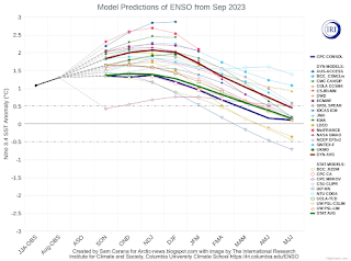
The question is whether temperatures will keep rising. The current El Niño is still strengthening, as illustrated by the image on the right, adapted from IRI, and there is more to be taken into account. 


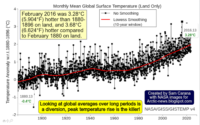
Until now, February 2016 has been the hottest month on record. The above image, from an earlier post, shows that February 2016 was 3.28°C (5.904°F) hotter than 1880-1896 on land, and 3.68°C (6.624°F) hotter compared to February 1880 on land. Note that 1880-1896 is not pre-industrial either and that sustained anomalies higher than 3°C are likely to drive humans into extinction. The image adds a poignant note: Looking at global averages over long periods is a diversion, peak temperature rise is the killer!

The situation raises questions. How much has the temperature risen? Will the temperature keep rising? What can be done about it? How can these questions best be answered?

The Paris Agreement mandate


During the UN Climate Change Conference scheduled to be held from November 30 to December 12, 2023, in Dubai, United Arab Emirates, the first Global Stocktake of the implementation of the Paris Agreement will be concluded.

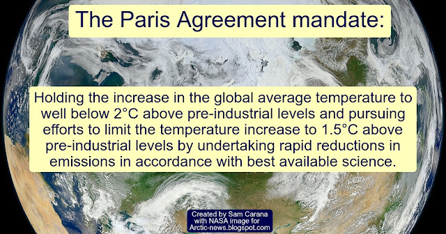
The 2015 Paris Agreement mandate: Holding the increase in the global average temperature to well below 2°C above pre-industrial levels and pursuing efforts to limit the temperature increase to 1.5°C above pre-industrial levels by undertaking rapid reductions in emissions in accordance with best available science.

Many assume that the temperature rise will only threaten to cross 1.5°C above pre-industrial in the second half of this century and that by that time action will have stopped the temperature from rising, with the idea that an increase in carbon sequestration could make up for remaining emissions and avoid dangerous climate change. 

The question is whether such assumptions and decisions are indeed based on best available science, as opposed to political whim. Indeed, politicians are vulnerable to collusion with lobbyists feeding suggestions that there was a carbon budget to divide among polluters to enable polluters to keep polluting for decades to come. Local People's Courts can best rule on such questions, after taking a closer look at points such as the following: 

  • Rise from pre-industrial - While many politicians keep pushing the idea that 1.5°C above pre-industrial hasn't been crossed yet, we may already have crossed 2°C above pre-industrial, as discussed in this analysis.

  • Policy choices - emission reductions are best achieved early, rather than late. Yet, many politicians keep supporting fuel (fossil fuel and biofuels) and envisage burning of fuel to continue well beyond 2050 (combined with BECCS). Instead, when taking into account damage to health and the environment, and the danger of runaway temperature rise, it should be clear that better policies must be implemented soon, such as local feebates, to support better methods and technologies such as biochar, heat pumps and eVTOL air taxis. 

  • Rising emissions - Politicians claim that merely stating to aim for net-zero emissions will suffice to reduce emissions, whereas the evidence shows that energy-related greenhouse gas emissions have started to grow again, following minor Covid lockdown-related reductions in 2020, as illustrated by the image below, from an earlier post
[ Global energy-related greenhouse gas emissions 2000-2022, adapted from EIA ]
  • Carbon sink loss - Carbon sinks have long been taking carbon out of the atmosphere, but they are struggling and many may turn from sinks into sources and instead add carbon to the atmosphere. In 2023, nearly 2bn tons of carbon is estimated to have already gone up into the atmosphere in Canada up to now due to forest fires, far exceeding annual emissions tied to Canada’s economy (i.e. 670m tons). As temperatures rise, trees become more vulnerable to diseases and insects such as bark beetles. A 2020 study shows that at higher temperatures, respiration rates continue to rise in contrast to sharply declining rates of photosynthesis. Under business-as-usual emissions, this divergence elicits a near halving of the land sink strength by as early as 2040. As temperatures rise, soils and vegetation will lose moisture to the atmosphere. The Land Evaporation Tipping Point can get crossed locally when water is no longer available locally for further evapotranspiration from the soil and vegetation, with the rise in land surface temperatures accelerating and vegetation decaying accordingly. Higher temperatures result in more extreme weather events, such as fires, droughts, storms, flooding and erosion, that can all contribute to further decrease the terrestrial carbon sink. The ocean is also struggling as a carbon sink, in part because increased river runoff and meltwater lowers alkalinity levels. Furthermore, warmer water holds less oxygen and is becoming more stratified and thus less able to supply nutrients to help plankton grow and store carbon

  • Hydroxyl loss - There is a danger that hydroxyl, the main way that methane gets broken down in the atmosphere, is declining or getting overwhelmed by the rise in methane, as described here.

  • Heat sink loss - This recent study and this one warn that AMOC (the Atlantic meridional overturning circulation) is slowing down faster than expected. A recent post warns that this can contribute to more hot water accumulating in the North Atlantic, as opposed to moving to greater depth. The post also warns that, as temperatures rise, less heat gets stored in oceans, because stratification increases and more heat can get transferred from oceans to the atmosphere as sea ice disappears. There also are indications that, over time, proportionally more heat is remaining in the atmosphere, while less heat gets stored on land. All this results in a hotter atmosphere. 
     
  • Albedo loss - Loss of sea ice, loss of snow cover and warming oceans causing fewer bright clouds combine to reflect less sunlight back into space, as discussed here and here
  • [ Two out of numerous feedbacks ]
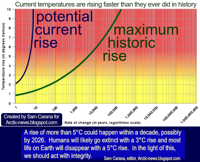
    Feedbacks - Important also is the accelerating rate of change. In many respects, we're in uncharted territory and changes are occurring faster than ever in Earth's history, which should be reason for caution and even more reason to plan ahead!

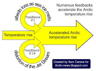
    The danger is growing that feedbacks are kicking in with ever greater ferocity, i.e. non-linear change. The image on the right, from an earlier post, illustrates how two self-reinforcing feedback loops can contribute to accelerate the Arctic temperature rise.

    [ click on images to enlarge ]
  • [ see the Extinction page ]
    Tipping Points - An even more dramatic form of non-linear change occurs when tipping points get crossed, and the consequences can be catastrophic for the entire world.

    The above image, from an earlier post, illustrates the danger that, as the latent heat and seafloor methane tipping points get crossed, the ocean temperature will keep rising as huge amounts of methane get released in the Arctic.

    It is essential to assess the danger of events and developments such as heat reaching and destabilizing methane hydrates contained in sediments at the seafloor of the Arctic Ocean, as discussed in many earlier posts such as this one.

    Seafloor methane is one of many elements that could jointly cause a temperature rise of over 10°C, in the process causing the clouds tipping point to get crossed that can push up the temperature rise by a further 8°C, as illustrated by the image on the right, from the extinction page

    Ominously, very high methane levels continue to be recorded at Barrow, Alaska, as illustrated by the NOAA image below.

Conclusion

Alarms bells have sounded loud and clear, such as here, warning that the temperature rise could be more than 3°C as early as in 2026. The precautionary principle should prevail and the looming dangers should prompt people into demanding comprehensive and effective action to reduce the damage and to improve the situation. To combat rising temperatures, a transformation of society should be undertaken, along the lines of this 2022 post in combination with a declaration of a climate emergency.


Links

• Climate Reanalyzer

• The International Research Institute for Climate and Society, Columbia University Climate School 

• Paris Agreement

• International Energy Agency (IEA) - Global energy-related greenhouse gas emissions 2000-2022

• NOAA - Barrow Atmospheric Baseline Observatory, United States
https://gml.noaa.gov/dv/iadv/graph.php?code=BRW&program=ccgg&type=ts

• Transforming Society
https://arctic-news.blogspot.com/2022/10/transforming-society.html

• Climate Plan
https://arctic-news.blogspot.com/p/climateplan.html

• Climate Emergency Declaration
https://arctic-news.blogspot.com/p/climate-emergency-declaration.html