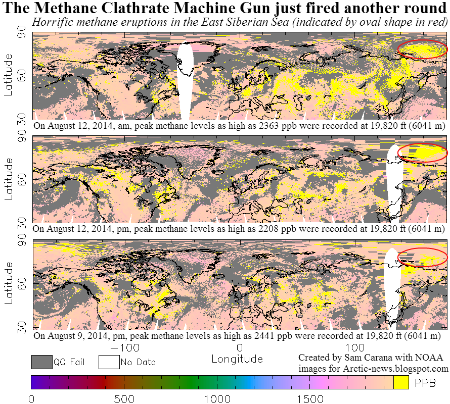
As the top image above shows, peak levels as high as 2363 ppb were recorded at an altitude of 19,820 ft (6041 m) on the morning of August 12, 2014. The middle image shows that huge quantities of methane continued to be present over the East Siberian Sea that afternoon, while the bottom image shows that methane levels as high as 2441 ppb were recorded a few days earlier, further indicating that the methane did indeed originate from the seafloor of the East Siberian Sea.
On August 12, 2014, peak methane levels at higher altitudes were even higher than the readings mentioned on above image. Levels as high as 2367 ppb were reached at an altitude of 36,850 ft (11,232 m). Such high levels have become possible as the huge quantities of methane that were released from the seafloor of the Arctic Ocean over the period from October 2013 to March 2014, have meanwhile descended to lower latitudes where they show up at higher altitudes.
Methane eruptions from the Arctic Ocean's seafloor helped push up mean global methane levels to readings as high as 1832 ppb on August 12, 2014.
Ironically, the methane started to erupt just as an international team of scientists from Sweden, Russia and the U.S. (SWERUS-C3), visiting the Arctic Ocean to measure methane, had ended their research.
Örjan Gustafsson describes part of their work: “Using the mid-water sonar, we mapped out an area of several kilometers where bubbles were filling the water column from depths of 200 to 500 m. During the preceding 48 h we have performed station work in two areas on the shallow shelf with depths of 60-70m where we discovered over 100 new methane seep sites.”
Örjan Gustafsson adds that “a tongue of relatively warm Atlantic water, with a core at depths of 200–600 m may have warmed up some in recent years. As this Atlantic water, the last remnants of the Gulf Stream, propagates eastward along the upper slope of the East Siberian margin, our SWERUS-C3 program is hypothesizing that this heating may lead to destabilization of upper portion of the slope methane hydrates.”
 |
| Schematics of key components of the Arctic climate-cryosphere-carbon system that are addressed by the SWE-C3 Program. a,b) Sonar images of gas plumes in the water column caused by sea floor venting of methane (a: slope west of Svalbard, Westbrook et al., 2009; b: ESAO, Shakhova et al., 2010, Science). c) Coastal erosion of organic-rich Yedoma permafrost, Muostoh Island, SE Laptev Sea. d) multibeam image showing pockmarks from gas venting off the East Siberian shelf. e) distribution of Yedoma permafrost in NE Siberia. f) Atmospheric venting of CH₄, CO₂. (SWERUS-C3) |
In 2010, team members Natalia Shakhova and Igor Semiletov estimated the accumulated methane potential for the Eastern Siberian Arctic Shelf alone to be as follows:
- organic carbon in permafrost of about 500 Gt;
- about 1000 Gt in hydrate deposits; and
- about 700 Gt in free gas beneath the gas hydrate stability zone.
Back in 2008, Shakhova et al. wrote a paper warning that “we consider release of up to 50 Gt of predicted amount of hydrate storage as highly possible for abrupt release at any time.”
Last year, a team of researchers including Professor Peter Wadhams calculated that such a 50 Gt release would cause global damage with a price-tag of $60 trillion.
As Prof Wadhams explains in the video below: “We really have no choice except to seriously consider the use of geoengineering.”
Sea surface temperatures as high as 18.8°C are now recorded at locations where warm water from the Pacific Ocean is threatening to invade the Arctic Ocean.
At the same time, huge amounts of very warm water are carried into the Arctic Ocean by the Gulf Stream through the North Atlantic. The image below illustrates how the Gulf Stream brings very warm water to the edge of the sea ice.
Waters close to Svalbard reached temperatures as high as 62°F (16.4°C) on July 29, 2014 (green circle). Note that the image below shows sea surface temperatures only. At greater depths (say about 300 m), the Gulf Stream is pushing even warmer water through the Greenland Sea than temperatures at the sea surface.
Since the passage west of Svalbard is rather shallow, a lot of this very warm water comes to the surface at that spot, resulting in an anomaly of 11.1°C. The high sea surface temperatures west of Svalbard thus show that the Gulf Stream can carry very warm water (warmer than 16°C) at greater depths and is pushing this underneath the sea ice north of Svalbard. Similarly, warm water from greater depth comes to the surface where the Gulf Stream pushes it against the west coast of Novaya Zemlya.
 |
| [ click on image to enlarge ] |
The images below give an impression of the amount of heat transported into the Arctic Ocean.
As said, the situation is dire and calls for comprehensive and effective action, as discussed at the Climate Plan blog at climateplan.blogspot.com and as illustrated by the image below.


