Showing posts with label East Siberian Arctic Shelf. Show all posts

Thursday, June 18, 2020

2020 Siberian Heatwave continues


Very high temperatures hit Northern Europe and Eastern Siberia near the Arctic Ocean on June 18, 2020. This is a continuation of the heatwave that hit Siberia in May 2020.

The image below, from an earlier post, shows temperature anomalies that were forecast to be at the high end of the scale over Siberia on May 22, 2020, 06:00 UTC, i.e. 30°C or 54°F higher than 1979-2000. At the same time, cold temperatures were forecast for much of eastern Europe.


What enables such a strong heatwave to develop is that the Jet Stream is getting more wavy as the temperature difference between the North Pole and the Equator is narrowing, causing both hot air to move up into the Arctic (red arrow) and cold air to descend out of the Arctic (blue arrow).

On June 19, 2020, at 03:00 UTC, a temperature of 33.2°C or 91.8°F was recorded in Siberia near the Arctic Ocean (green circle).


The image below shows a temperature forecast of 33.5°C or 92.2°F in Siberia near the Arctic Ocean on June 20, 2020, at 03:00 UTC (green circle).


The image below is a forecast for June 23, 2020, showing how a distorted Jet Stream enables cold air to move down into Russia, while at the same time enabling hot air to move north over Scandinavia and Siberia, near the Arctic Ocean.


The image below is a forecast for June 25, 2020, showing the coast of Siberia near the Arctic Ocean getting hit by temperature anomalies at the top end of scale, i.e. 30°C or 54°F higher than 1979-2000.


The image on the right is an update, showing how wavy the Jet Stream turned out to be on June 25, 2020.

This facilitates hot air getting carried north over Western Europe, East Siberia and through the Bering Strait, while cold air is moving south over the European part of Russia. Blocking patterns that prolong such a situation go hand in hand with a more wavy Jet Stream.

Record High Temperature in Arctic

The image below shows that temperatures in Siberia were as high as 40°C or 104°F at 5 cm above the ground on June 21, 2020, at 3 pm, the Ventusky.com map shows.


This indicates how much the soil of what once was permafrost is heating up. At 2 m above ground level, i.e. the default height for air temperature measurements, it was 30°C or 86°F, as the image below shows. The location marked by the star is at 71°28' North latitude and 142°59' East longitude, and at and altitude of 13 m.


The day before, Verkhoyansk in Siberia reached a temperature of 38°C or 100.4°F on June 20, 2020, a record high for the Arctic. Verkhoyansk is located at 67°55′ North latitude.

Both locations are well north of the Arctic Circle that - at 66°30′ N - constitutes the southern limit of the area within which, for one day or more each year, the Sun does not set (about June 21) or rise (about December 21).

High Ocean Temperatures

The heatwave is heating up the sea surface of the East Siberian Arctic Shelf (ESAS), as illustrated by above image. The ESAS is quite shallow, making that heat can quickly reach the seafloor.

Additionally, the heatwave is heating up rivers that carry large amounts of hot water into the Arctic Ocean.

The image on the right shows sea surface temperatures in the Bering Strait as high as 18.9°C or 66.02°F on June 22, 2020.

The nullschool.net website shows that sea surface temperatures in the Bering Strait were as high as 16.1°C or 60.9°F on June 20, 2020, in the Bering Strait (in Norton Sound, Alaska), i.e. 15.1°C or 27.2°F hotter than 1981-2011.


In summary, the Arctic Ocean is heating up in a number of ways:

- Sea currents are moving hot water from the Pacific Ocean into the Arctic Ocean. Similarly, sea currents are moving hot water from the Atlantic Ocean into the Arctic Ocean.

- The Siberian heatwave is heating up the sea surface of the ESAS.

- The heatwave is heating up rivers that carry large amounts of hot water into the Arctic Ocean.

- Numerous feedbacks can speed up the temperature rise, such as changes to the jet stream that can prolong heatwaves and make them more intense.

The rising temperatures result in record low Arctic sea ice volume, as illustrated by the image on the right and as also discussed in an earlier post.

Heat threatens to destabilize methane hydrates

As discussed in earlier posts such as this one, this heat threatens to destabilize methane hydrates contained in sediments at the seafloor of the Arctic Ocean.


As the panel on the left shows, sea surface temperatures in the Bering Strait were as much as 15.1°C or 27.2°F hotter than 1981-2011 on June 20, 2020 (in Norton Sound, Alaska, at the green circle).

The bathymetry map in the right panel of above image shows how shallow seas in the Arctic Ocean can be. The water over the ESAS is quite shallow, making that the water can warm up very quickly during summer heat peaks and heat can reach the seafloor, which comes with the risk that heat will penetrate cracks in sediments at the seafloor. Melting of ice in such cracks can lead to abrupt destabilization of methane hydrates contained in sediments.

Large abrupt methane releases will quickly deplete the oxygen in shallow waters, making it harder for microbes to break down the methane, while methane rising through waters that are shallow can enter the atmosphere very quickly.

The situation is extremely dangerous, given the vast amounts of methane present in sediments in the ESAS, given the high global warming potential (GWP) of methane following release and given that over the Arctic there is very little hydroxyl in the air to break down the methane.

[ from earlier post ]

Ominously, the MetOp-1 satellite recorded a peak methane level of 2847 parts per billion on the afternoon of June 24, 2020, at 469 mb.


The next day, on the afternoon of June 25, 2020, MetOp-1 recorded a mean methane level of 1903 parts per billion at 293 mb. The 469 mb pressure level on above image corresponds with altitude of 6,041 m or 19,820 feet on the conversion table below. The 293 mb mean on the image below corresponds with a much higher altitude, i.e. 9,318 m or 30,570 feet on the conversion table below.


Methane reaching the Stratosphere

The MetOp satellites typically record the highest annual mean methane level in September. The image below, from an earlier post, shows that on the afternoon of September 30, 2019, the MetOp-1 satellite recorded the highest mean methane level, i.e. 1914 parts per billion, at 293 mb.


Above image shows that methane levels have risen most at higher altitude over the years. As discussed in an earlier post, methane eruptions from the Arctic Ocean can be missed by measuring stations that are located on land and that often take measurements at low altitude, thus missing the methane that rises in plumes from the Arctic Ocean. Since seafloor methane is rising in plumes, it hardly shows up on satellite images at lower altitude either, as the methane is very concentrated inside the area of the plume, while little or no increase in methane levels is taking place outside the plume. Since the plume will cover less than half the area of one pixel, such a plume doesn't show up well at low altitudes on satellite images.

Over the poles, the Troposphere doesn't reach the heights it does over the tropics. At higher altitudes, methane will follow the Tropopause, i.e. the methane will rise in altitude while moving closer to the Equator.

Methane rises from the Arctic Ocean concentrated in plumes, pushing away the aerosols and gases that slow down the rise of methane elsewhere, which enables methane erupting from the Arctic Ocean to rise straight up fast and reach the stratosphere.

The rise of methane at these high altitudes is very worrying. Once methane reaches the stratosphere, it can remain there for a long time. The IPCC in 2013 (AR5) gave methane a lifetime of 12.4 years. The IPCC in 2001 (TAR) gave stratospheric methane a lifetime of 120 years, adding that less than 7% of methane did reach the stratosphere. 

Further Feedbacks

Furthermore, the Siberian heatwave is also threatening to trigger forest fires that can cause huge amounts of emissions, including black carbon that can settle on the snow and ice cover, further speeding up its demise and causing albedo changes that result in a lot more heat getting absorbed in the Arctic, instead of getting reflected back into space as was previously the case. This is illustrated by the image below showing forest fires in East Siberia on June 19, 2020.


Finally, more intense forest fires threaten to cause organic carbon compounds to enter the stratosphere and damage the ozone layer, as discussed in an earlier post.

The situation is dire and calls for immediate, comprehensive and effective action as described in the Climate Plan.


Links

• Climate Plan
https://arctic-news.blogspot.com/p/climateplan.html

• Very High Greenhouse Gas Levels
https://arctic-news.blogspot.com/2020/05/very-high-greenhouse-gas-levels.html

• April 2020 temperatures very high
https://arctic-news.blogspot.com/2020/05/april-2020-temperatures-very-high.html

• Methane Erupting From Arctic Ocean Seafloor
https://arctic-news.blogspot.com/2017/03/methane-erupting-from-arctic-ocean-seafloor.html

• When Will We Die?
https://arctic-news.blogspot.com/2019/06/when-will-we-die.html

• Could Humans Go Extinct Within Years?
https://arctic-news.blogspot.com/2020/01/could-humans-go-extinct-within-years.html

• Fast Path to Extinction
https://arctic-news.blogspot.com/2020/06/fast-path-to-extinction.html

• Arctic records its hottest temperature ever
https://www.cbsnews.com/news/arctic-records-its-hottest-temperature-ever-2020-06-20/


Sunday, November 2, 2014

Methane Erupting From East Siberian Arctic Shelf

Methane is erupting in huge amounts from the seafloor of the Arctic Ocean, as illustrated by the images below, showing methane over the East Siberian Arctic Shelf on October 31, 2014.

The top image on the right shows methane at an altitude of 19,820 feet (6,041 m), on October 31, 2014, pm, as captured by the MetOp1 satellite.

The middle image shows the location of the seas north of Siberia, and shows methane over the Arctic Ocean close to sea level, for reference.

The bottom image is an animation, starting at an altitude close to sea level and rising over 25 frames to an altitude of 19,820 feet (6,041 m).

As altitude increases, the methane can be seen emerging from the Laptev Sea at first, then spreading over further parts of the Arctic Ocean.

The yellow color indicates that methane is present at levels of 1950 ppb or higher.

High CO2 levels over Arctic Ocean

As in the previous post, an image has been added (below) showing recent carbon dioxide levels. Close to ground level (or rather sea level), mean CO2 level increased to 402 ppm on November 1, 2014 am, as measured by the MetOp-1 satellite.


The image below shows a comparison between CO2 (left) and methane (right).

[ Image added later, Ed. Click on image to enlarge ]
Above images indicate that large amounts of methane are broken down at higher latitudes on the Northern Hemisphere, especially over the Arctic Ocean.

Large methane eruptions from the seafloor of Arctic Ocean continue

The two images below [added later, ed.] further confirm the huge size of the methane erupting from the seafloor of the Arctic Ocean. The image directly below shows that levels as high as 2362 ppb were recorded on November 5, 2014 p.m.by the MetOp-1 satellite at an altitude of 14,385 ft (4,384 m) altitude. The image also shows that the methane is predominantly visible over the Arctic Ocean, further confirming that this is indeed the cause of the continued high methane levels.


The recent methane eruptions from the seafloor of the Arctic Ocean also appear to be pushing up methane levels at Mauna Loa, Hawaii, as measured by NOAA on November 6, 2014, as illustrated by the combination image below showing daily averages (left) and hourly averages (right).


Methane eruptions from Arctic Ocean seafloor look set to continue for months to come

As oceans keep warming, the Gulf Stream
will keep moving ocean heat into the Arctic Ocean, and ever more methane threatens to erupt from the seafloor of the Arctic Ocean.

The image on the right shows the huge sea surface temperature anomalies off the coast of North America and in the Arctic. Heat in the North Atlantic will take some time to travel to the Arctic Ocean, so this heat has yet to arrive there and contribute to cause further methane eruptions.

Nations are ignoring the growing dangers and keep each seeking a bigger share of a 'carbon budget', but in reality there is no carbon budget to divide. Instead, there is a huge debt built up by a joint failure of nations to act on pollution.

Increased methane eruptions from the seafloor of the Arctic Ocean threaten to further accelerate warming in the Arctic, in turn resulting in ever more methane being released, as illustrated in the image below, from an earlier post.

Methane in historic perspective

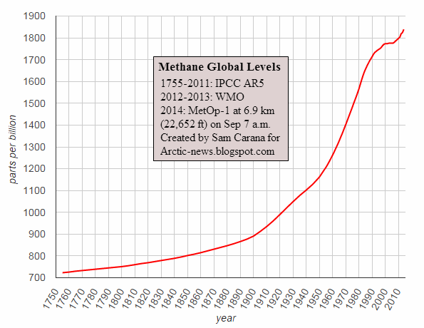
The image below shows that global methane levels have risen from 723 ppb in 1755 to 1839 ppb in 2014, a rise of more than 254%. Growth did flatten down for a few years in the early 2000s, but the overall rise does not appear to slow down.

The right-end of this graph is shown in greater detail on the image below, which also has a trendline extended to the year 2021, against a background of methane levels measured by the MetOp-1 satellite on November 2, 2014, p.m.

Note that the image used as background in the plot area has different axis labels, i.e. latitude for the vertical axis and longitude for the horizontal axis. The image below gives the levels associated with the colors on the background image, with yellow indicating levels of 1950 parts per billion (ppb) and higher.


Remember that the level of 723 ppb in 1755 was not a paleo-historic low, but instead was the high peak of a Milankovitch Cycle. The image below further illustrates this point.


And so does the image below, by Reg Morrison.


Comprehensive and effective action needed

The situation is dire and calls for comprehensive and effective action. The Climate Plan seeks emission cuts, removal of pollution from soils, oceans and atmosphere, and further action, as illustrated by the image below, from an earlier post.


Sunday, November 24, 2013

Quantifying Arctic Methane

The paper 'Ebullition and storm-induced methane release from the East Siberian Arctic Shelf', was published in the journal Nature Geoscience on November 24, 2013.

The paper is dedicated “to the memory of the crew of Russian vessel RV Alexei Kulakovsky”, the 11 people who died when their tugboat perished in efforts to assist the scientists who were measuring methane from a fishing boat.

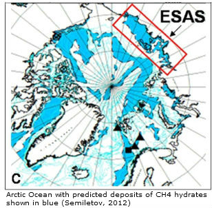
The research team used methods including drilling into the seabed of the Laptev Sea and sonar to analyse methane releases in the water, seeking to quantify the significant amounts of methane that are bubbling up from the sea bed in the East Siberian Arctic Shelf (ESAS, rectangle on image below), the area with shallow seas north of Siberia covering some 810,800 square miles (2.1 million square kilometers). By comparison, the United States (land and water) covers an area of nearly 10 million square kilometers.

“We have proven that the current state of subsea permafrost is incomparably closer to the thaw point than terrestrial permafrost, and that modern warming does contribute to warming the subsea permafrost,” says Natalia Shakhova, adding that an increase in storminess in the Arctic would further speed up the release of methane.

The scientists estimate, on the basis of the sonar data, that “bubbles escaping the partially thawed permafrost inject 100–630 mg methane square meters daily into the overlying water column”, and suggest that “bubbles and storms facilitate the flux of this methane to the overlying ocean and atmosphere, respectively”.

Some 17 teragrams (Tg or Mt) of methane escapes annually from the ESAS, said Natalia Shakova, lead study author and a biogeochemist at the University of Alaska, Fairbanks. This is an upgrade from the earlier estimate of 8 Tg of annual outgassing from the ESAS (Shakhova et al. 2010).

While including a reference to this earlier paper (Shakhova et al. 2010), the IPCC did give much lower estimates for emissions from all hydrates globally and from permafrost (excl. lakes and wetlands), i.e. 6 and 1 Tg per year, respectively.

And by comparison, IPCC estimates for all global methane emissions from manmade and natural sources go from 526 Tg per year to 852 Tg per year, of which 514 to 785 Tg per year is broken down (mostly by hydroxyl).

Sadly, as discussed in an earlier post, the IPCC has decided NOT to warn people about the danger that methane from hydrates will lead to abrupt climate change within decades. Yet, when entering the data by Shakhova et al. in a spreadsheet, a linear trendline (green line on image below) shows methane release in the ESAS reaching 20 Tg by 2013 and 26 Tg by 2015.


An exponential trendline (red/blue line) shows methane release in the ESAS reaching 22 Tg by 2013 and 36 Tg by 2015. Extending that same exponential trendline further into the future shows methane release in the ESAS reaching 2 Gt by the year 2031 and 50 Gt by the year 2043.


Note that accumulated totals over the years will be much higher than the annual release. While the IPCC gives methane a perturbation lifetime of 12.4 years, this methane will persist in the Arctic for much longer because its release is concentrated in the Arctic where hydroxyl levels are also very low.

Globally, IPCC/NOAA figures suggest that abundance of methane in the atmosphere currently (2013) is 1814 parts per billion (ppb), rising with 5 or 6 ppb annually, and that this rise is caused by a difference of 8 Tg between the methane emitted (548 Tg, top-down estimate) and broken down annually (540 Tg, top-down estimate). It is also worth noting that the IPCC has increased methane's global warming potential to 86 over 20 years with climate-carbon feedbacks, while there are reasons to assume that methane's impact, especially short-term and in case of large abrupt releases in the Arctic, is even stronger. Furthermore, the IPCC now gives methane a Radiative Forcing (RF) of 0.97 W/m-2 (up from 48 W/m-2 in 2007 and relative to 1750), as illustrated by the image below.


According to the IPCC, methane levels in 1750 and 2011 were 722 ppb and 1803 ppb, respectively. The total global methane burden is estimated to be about 5 Gt, i.e. 5 petagrams (Pg) or 5,000 Tg. A back-of-envelope calculation sugests that the methane burden in 1750 was 5 Gt x (722 : 1803) = 2 Gt. Furthermore, methane's 0.97 W/m-2 RF is 42% of the total RF 2.29 W/m-2. Therefore, the 3 Gt of methane that has been added to the atmosphere since 1750 is responsible for almost half of all the global warming since that time.

For now, the IPCC's estimated annual increase in global methane levels may seem small, but this figure appears to be based on low-altitude data collected over the past few decades. The total methane burden may already be rising much more rapidly, also because methane is rising in the atmosphere, increasing the burden especially at higher altitudes, as evidenced by the increasing occurence of noctilucent clouds. In other words, the 8 Tg estimate may reflect older data related to changes in lower-altitude measurements only, but the total methane burden may well be rising much more rapidly due to increases at higher altitudes. Further analysis comparing satellite data at different altitudes over the years could verify this.

An earlier post estimated that as much as 2.1 Mt (or 2.1 Tg) of methane could have been released abruptly end 2011. If you compare the animation of that earlier post with the recent animation, then current abrupt releases from the sea floor of the Arctic Ocean appear to be even higher.

As said, methane releases from the Arctic Ocean may for now seem small and may not yet make global temperatures rise much, but nonetheless the methane cloud hanging over the Arctic is contributing to warming locally. Combined with the increased likelyhood of extreme weather and rapid loss of ice and snow cover in the Arctic, this could make water temperatures in the Arctic Ocean rise even further, causing further destabilization of methane hydrates. Furthermore, the mechanical force of methane release from hydrates (rapidly expanding 160 times in volume) itself can also contribute to hydrate destabilization. Seismic activity could also lead to destabilization. Indeed, there are many factors that could contribute to exponential rise of methane release from the Arctic Ocean, as discussed in the post on methane hydrates, which calls for comprehensive and effective action, such as discussed at the Climate Plan blog.


References

Ebullition and storm-induced methane release from the East Siberian Arctic Shelf, by Natalia Shakhova, Igor Semiletov, Ira Leifer, Valentin Sergienko, Anatoly Salyuk, Denis Kosmach, Denis Chernykh, Chris Stubbs, Dmitry Nicolsky, Vladimir Tumskoy & Örjan Gustafsson (2013)
http://www.nature.com/ngeo/journal/vaop/ncurrent/full/ngeo2007.html

Arctic storms speed up release of methane plumes, by Fred Pearce
http://www.newscientist.com/article/dn24639-arctic-storms-speed-up-release-of-methane-plumes.html

Twice as Much Methane Escaping Arctic Seafloor, by Becky Oskin
http://www.livescience.com/41476-more-arctic-seafloor-methane-found.html

Extensive methane venting to the atmosphere from sediments of the East Siberian Arctic shelf, by Natalia Shakhova, Igor Semiletov, Anatoly Salyuk, Vladimir Yusupov, Denis Kosmach, and Örjan Gustafsson, in: Science, 327, 1246-1250 (2010).
http://www.sciencemag.org/content/327/5970/1246.abstract

On carbon transport and fate in the East Siberian Arctic land–shelf–atmosphere system, by Semiletov et al. (2012)
http://iopscience.iop.org/1748-9326/7/1/015201

Intergovernmental Panel on Climate Change (IPCC), AR5 Working Group 1
http://www.climatechange2013.org/


Thursday, October 24, 2013

Epic Methane Releases from East Siberian Arctic Shelf

By Harold Hensel

[ click to enlarge ]

This is epic! Keep watching the Laptev and East Siberian Sea. This is a very dangerous place for methane to come up. Huge amounts of methane hydrates are stored below. They have been frozen there safely for over 10,000 years.

We are witnessing the thawing and large release of methane from this area for the first time in over 10,000 years. The fear is that at a critical point there may be a catastrophic sudden burst of methane from this area. This would more than likely trigger runaway global warming.

We could be watching the beginnings of this. If the red on the 1750 ppb and the yellow on the 1950 ppb setting on the methanetracker.org keeps spreading and intensifies, we are watching it happen. I hope this is an anomaly and these areas return to little or no activity.


Harold Hensel is at Facebook as facebook.com/mhhensel

Tuesday, March 12, 2013

The worst-case and - unfortunately - looking almost certain to happen scenario

Aaron Franklin
By Aaron Franklin

I have asked for the world leading climate and arctic scientists I have been working with at AMEG, and Arctic-News to review this, and if they don't agree with any part or the end conclusion to please inform me immediately.

As yet no-one has come forward, with any criticisms whatsoever, only agreement that this is what we are very likely facing.


If we don't act very fast and the Arctic sea ice goes...

Up till now the sea ice, and the pool of low salinity meltwater left on the surface of the arctic ocean from it melting has blocked the warm Gulf stream from getting any further than the strip of coast with a shallow continental shelf seabed, around the north of Europe and western Russia as far as the islands and peninsulars that jut north from the west Siberian coast.

High salinity, warm gulfstream water of tropical origin does not mix freely with cold low density low salinity meltwater. It mixes and sinks in a sheet current at the boundary between these two bodies of water.

This has not caused any big problems so far as it has been happening along a fairly short boundary above shallow continental shelf and the downwards mixed flow is slowed by flowing over the the shelf before it sinks into the deep polar basin.

However... the meltpool on top of the Arctic ocean has been getting smaller every year and if we let the gulf stream get any further than it has to date then it will most likely continue all the way along the east Siberian coast, combine with the warm bering strait inflow, encircle the whole polar basin. Or at least most of it, if there is still enough multi-year sea-ice damming up against the west coast of the north Canadian archipelago to stop it getting to the extreme Canadian side of the arctic ocean.

There probably isn't enough multiyear seaice left to do this anyway and it won't make any differency to the overall outcome anyway, which is....

Encouraged by the anti-clockwise, low level Arctic atmospheric wind vortex (the low pressure system that is usually in place over the nth pole) the gulf-stream loop will accelerate, forming a mixing vortex (whirlpool), first sucking down any remaining surface meltwater pool to deep polar ocean, along a long circular front above the deep polar basin.

As this is happening the Gulf stream and Bering strait warm water inputs will accelerate dragging ever warmer water in, and the entire Arctic ocean near surface region will flood with warm high salinity water at up to 12C or even higher.

This will eliminate any chance of the arctic ocean refreezing in winter. And:

The average 12C temperatures of the upper layer of the polar ocean will be sending a big thermal pulse down through the East Siberian Arctic Shelf and other shallow submarine permafrosts in the arctic. This pulse propagating fast through liquid water in cracks and methane eruption vents. The hydrate layers containing over 1000 billion tons C of methane at the bottoms of these permafrosts will be destabilising, bottom up, when that thermal pulse pins them between itself and rising geothermal heat.

The ESAS and other Arctic shelf Methane Hydrate reefs will be fizzing like an alka-seltzer in a glass of warm water, and the wind-turbulated open water will mean lots of that methane getting into the atmosphere and spiking global warming.

As the sun has set for the north polar winter at this point, the northern Alaskan, Siberian, and Canadian tundras will cool rapidly as usual. But this time the warm surface of the polar ocean will be releasing water vapour and this warm low density air/water vapour mixture will rise, accelerating the polar low into a very deep arctic storm system, very likely far stronger than any we've ever seen.

This will erupt warm water vapour bearing air high into the troposphere, and stratosphere above the pole and this will suck in the cold air from over Alaskan, Siberian, and Canadian tundras, drawing in air from further south and causing heavy winter rainfall rather than light snowfall. (usually in winter polar highs are dominant and descending cold dry air from these flows out over the Alaskan, Siberian, and Canadian tundras).

The tundra permafrosts will now be drenched in large volume rainfalls. The warm lakes and bogs all over them will be drilling through the permafrost, and lots of the around 1700 billion tons C of organic carbon locked up in the land permafrost will be flooding into the Arctic Ocean from Siberia, Alaska and North Canada. And getting sucked down the polar plughole. Lots will be getting released into the air as methane and carbon dioxide, and spiking global warming.

The donut-shaped circulation pattern sitting like a crown over the Arctic circle will start drawing down stratospheric air from further south.

Sometime soon, very probably in the nest northern summer monsoon season...

-At this point the extra methane, ozone, water vapour, and the loss of sea ice reflecting sunlight back into space will together be producing about 3x present day global warming effect.

and...

The jetstreams that are formed by warm moist air rising from the equator, dumping that moisture as heavy tropical rain in the tropics usually descend in the subtropical desert belts that circle the globe. They like cogs intermeshing will connect with the polar donut, drawing the summer monsoon north over the subtropical desert belts and building rapidly to tropical rainfall levels over the worlds deserts.

The dry descending air from the equatorial and north polar origin tropospheric flows and jetstreams will turn the temporate zones of the northern hemisphere into deserts in one year.

The ex tundra boglands will start to dry out. Its been learnt that when you thaw and soak permafrost peats, waking up the frozen bacteria. Then drain them....

-Significant quantities of Nitrous Oxide (N2O) start being emitted. Another "super-greenhouse" gas, with its own special radiative absorption band.

-With even more water vapour, more methane, more N2O, more ozone being produced by the methane, less SO2 forming clouds because methane destroys it....

Global warming will start to spike very high.

What happens maybe very quickly now is that an equatorial origin jetstream will either detach from its mode of descending at the new temporate zone deserts and form a new anticyclone most probably over greenland, or the anticyclone from that jetstream will migrate north from the subpolar tundras over North Canada.

Either way this special anticyclone with a very big future, will winch its way around the polar low in the new easterly "tradewinds belt" where the tundras and boreal forests are now. It will probably end up over the Beaufort sea, north of Alaska and recruiting more stratospheric jetstreams of Equatorial origin, quickly grow in strength. It will start a new clockwise ocean surface vortex in the Beaufort sea region, and if any iceflows and cold meltwater are still trapped against the west coast of the Canadian Archipelago.....

They will get sucked into this new clockwise vortex and it will love feeding on them and growing just like in the first anticlockwise vortex described above.

The new polar super anticyclone will out compete the previous polar super cyclone by one by one recruiting all the equatorial and tropical origin jetstreams, and become a, for any relevance to us, permanent, extremely powerful anticyclone over the whole polar ocean.

The new clockwise polar ocean vortex will be accelerated by the clockwise anticyclonic low atmospheric vortex. There will likely be lots of Glacier calved icebergs from Greenland, stuck against the west coast of the Canadian Archipelago. It will love gobbling, melting, and feeding on those.

It will steal the deep subduction from, and outcompete and swallow the previous anticlockwise polar ocean vortex.

Powering up this vast whirlpool, will suck in ever increasing flows of Atlantic and Pacific water, flooding the Arctic ocean with more and more tropical water. It will shovel more and more warm surface water like a wedge into a new intermediate temperature, high salinity layer, building between the tidal mixed zone and the surface mixed layer .

This intermediate layer is said to be the mechanism that produces anoxic oceans in past super-greenhouse/ anoxic ocean events. And this will happen fast because....

The tundra permafrosts will be seasonal deserts, but much warmer now. In summer they will be drenched by tropical temperature and volume rainfalls, hammered by cold fronts, supercell storms and tornados spitting off the high lattitude Megacyclones. The warm lakes and bogs all over them will be drilling through the permafrost, and more of the around 1700 billion tons C of organic carbon currently locked up in the land permafrost will be flooding into the arctic ocean from Siberia, Alaska and Nth Canada. And getting sucked down the polar plughole. More methane and CO2 will be making it into the atmosphere

In winter the ex tundras will dry out. Releasing yet more N2O and CO2.

Global Warming will spike through the roof.

And...

The by now over 20 degrees Celsius temperatures of the upper layer of the polar ocean will be sending a massive thermal pulse down through the East Siberian Arctic Shelf (ESAS) and other shallow submarine permafrosts in the arctic. This pulse propagating fast through liquid water in cracks and methane eruption vents. The hydrate layers containing over 1000 billion tons C of methane at the bottoms of these permafrosts will destabilise fast, bottom up, when that thermal pulse hits them. Quite possible the pressure building up under these shelves, most particularly the ESAS will shatter them and release most of the hydrate methane, free methane, and undecomposed organic carbon, they are holding very fast indeed. Best estimate around 2750 billion tons C total in shallow submarine arctic permafrosts.

Kinda like a warm well shook champagne bottle when you pop the cork.

Lots of this methane will hit the atmosphere.

With even more water vapour, more methane, more N2O, more ozone being produced by the methane, less SO2 forming clouds because methane destroys it....

Ballpark Chart for near filling of all relevant Radiative Absorption bands


We'll have a greenhouse effect like the earth has not seen before in its 4.5 billion years of existence.

What REALLY concerns me looking at this chart is how much it would take going from this point to the Tipping Point for the Venus syndrome.

The situation in this chart would lead to a lot more stratospheric water vapour feedback. That could start to run away until the equatorial oceans boil, and there's no stopping things from there.


Lots of methane will get sucked down the Arctic plughole into the new anoxic intermediate ocean layer.

Archer 2007 states that 1000 billion tons C of methane (and/or other dissolved organic carbon) is sufficient to remove all oxygen from the worlds oceans. That won't take long.
  • The polar ocean vortex might eventually stop. The momentum in ocean circulation, both deep and in surface gyres, combined with wind driven surface currents won't let this happen fast.
  •  In maybe 300-1000yrs a second even larger methane release will occur, as the heat from the surface reaches the deep sea bed. The deep sea Methane hydrates are estimated as between 5000 and 78 000 billion tons C of methane. That will not be nice at all, but there may be nothing left but bacteria well before then anyhow.
  •  The tropical/subtropical origin MegaCyclones to polar Mega AntiCyclone jetstreams with low atmosphere return system will most probably stick around for at least 100 000 years. 
  • The previous anoxic supergreenhouse/anoxic ocean events did have stalled ocean circulation, and the only way that they could have had 27C polar ocean temps like they did is by the Equatorial-Polar jetstream circulation mode described above. 
  • The most serious previously, the end-permian had no polar basin, oceanic/ atmosphere circulation, turbine pump "beartrap" for the planetary eco-geosphere to put its foot in. Neither did the PETM and Elmo supergreenhouse/anoxic ocean events, the most serious of the last 100+ million years, the polar basin was landlocked for those. 
  • Never before could the earth have had as much polar permafrost methane and carbon as it does now. 
I hope this explains to everyone the urgency and seriousness of the current situation, and why we need to act with overwhelming force to stop the arctic sea-ice going this year.

If we don't act fast now all this could very well unfold unstoppably in the next year or two. Can't see it taking much longer than 10 or 20 at the most.

Saturday, July 14, 2012

How extreme will it get?

The January-June period was the warmest first half of any year on record for the contiguous United States, reports NOAA in its June 2012 overview. The national temperature of 52.9°F was 4.5°F (2.5°C) above average. 

The United States Department of Agriculture has designated 1,016 primary counties in 26 states as natural disaster areas, making it the largest natural disaster in America ever.  

The U.S. Drought Monitor has declared 80% of the Contiguous U.S. to be abnormally dry or worse, with 61% experiencing drought conditions ranging from moderate to exceptional—the largest percentage in the 12-year history of the service.  

In the 18 primary corn-growing states, 30% of the crop is in poor or very poor condition. In addition, fully half of the nation’s pastures and ranges are in poor or very poor condition. The year-to-date acreage burned by wildfires has increased to 3.1 million. 

NOAA reports record temperatures in many places; in Mc Cook, Neb., it was 115°F (46°C) on June 26, while in Norton Dam, Kan., it was 118°F (48°C) on June 28. Meanwhile, it was 126°F (52°C) in Death Valley National Park on July 10, 2012.

Lake Michigan surface water temperatures recently reached temperatures of up to 83.9°F (29°C), as shown on the image right. Lake Michigan has a surface area of 22,400 square miles (58,000 square kilometers). The lake's average depth is 279 ft (85 m), while its greatest depth is 923 ft (281 m). The image below compares 2012 surface water temperature with the average for 1992-2011.


Earlier this year, in March 2012, another heatwave hit much the same area. A NOAA analysis of the heatwave notes the abrupt onset of the warmth at Minneapolis, Duluth, and International Falls on 10 March. On subsequent days, anomalies of well over 20°C (36°F) were recorded as shown on the image on the right.
Temperature anomalies of 27+°F (15+°C) were recorded in a large area from March 12th to March 23rd, 2012, as shown below. 

 
Global warming is responsible for much of the frequency and intensity of extreme weather events and this is linked to developments in the Arctic, where accelerated warming is changing the jet stream, concludes an analysis by Rutgers University professor Jennifer Francis.

Apart from the obvious impact that droughts and heatwaves have on food and fresh water supply, they also come with wildfires that cause additional emissions, constituting a further positive feedback that further contributes to global warming, while the additional soot makes things even worse in the Arctic.

All this combines to create a situation in the Arctic where extreme local warming events can trigger methane releases, causing further local warming and further releases of methane, in a vicious cycle that threatens to escalate into runaway global warming that feeds on itself.  


The above image pictures the three kinds of warming (red lines) and their main causes:
  1. Emissions by people cause global warming, with temperatures rising around the globe, including the Arctic.
  2. Soot, dust and volatile organic compounds settle down on snow and ice, causing albedo change. More heat is absorbed, rather than reflected as was previously the case. This causes accelerated warming in the Arctic.
  3. Accelerated warming in the Arctic threatens to weaken methane stores in the Arctic with the danger that releases will cause runaway global warming.

In addition, there are at least three feedback effects (gold lines) that make things even worse:
  • Fires feedback: Accelerated warming in the Arctic is changing the Jet Stream, contributing to increased frequency and intensity of droughts and heatwaves.
  • Albedo feedback: Accelerated warming in the Arctic also speeds up the decline of ice and snow cover, further accelerating albedo change.
  • Methane feedback: Methane releases in the Arctic further add to the acceleration of warming in the Arctic, further contributing to weaken Arctic methane stores, in a vicious cycle that threatens to escalate into runaway global warming.


Rapid warming periods in the past constitute an ominous warning. In a paper published about a year ago, Ruhl et al. conclude that the end-Triassic mass extinction, about 200 million years ago, started with global warming due to carbon dioxide from volcanoes. This also caused warming of oceans and melting of hydrates at the bottom of the sea, containing methane created by millions of years of decomposing sea life. The hydrates released some 12,000 gigatons of methane, causing global warming to accelerate and resulting in sudden extinction of about half the species on Earth at the time.

The above image pictures how a similar thing could happen in our times, with global warming leading to accelerated warming in the Arctic, triggering hydrate destabilization and abrupt release of, say, 1 Gt of methane, which would further accelerate Arctic warming and lead to subsequent releases of methane from hydrates.

For more details on above two graphs, see the page How much time is there left to act?

Could extreme weather, like the U.S. is now experiencing, also occur in the Arctic?

Well, it actually did, not too long ago. Above image on the right, from the Cryosphere Today, shows air temperature anomalies in the Arctic of up to 6°C (10.8°F) for the month September 2007.

By how much will the sea warm up during such extreme local warming events?

The image on the right, produced with NOAA data, shows mean coastal sea surface temperatures of over 10°C (50°F) in some areas in the Arctic on August 22, 2007.

How extreme was this?

The image below, from NOAA, shows that sea surface temperature anomalies of over 5.5 were recorded for August 2007 in some areas in the Arctic.


Could such warming reach the bottom of the sea?

Again, this did happen in 2007, when strong polynya activity caused more summertime open water in the Laptev Sea, in turn causing more vertical mixing of the water column during storms in late 2007, according to one study, and bottom water temperatures on the mid-shelf increased by more than 3°C (5.4°F) compared to the long-term mean.

Another study finds that drastic sea ice shrinkage causes increase in storm activities and deepening of the wind-wave-mixing layer down to depth ~50 m (164 ft) that enhance methane release from the water column to the atmosphere. Indeed, the danger is that heat will warm up sediments under the sea, containing methane in hydrates and as free gas, causing large amounts of this methane to escape rather abruptly into the atmosphere.

Would this heat be able to penetrate sediments?
The image on the right, from a study by Hovland et al., shows that hydrates can exist at the end of conduits in the sediment, formed when methane did escape from such hydrates in the past. Heat can travel down such conduits relatively fast, warming up the hydrates and destabilizing them in the process, which can result in huge abrupt releases of methane.

Since waters can be very shallow in the Arctic, much of the methane can rise up through these waters without getting oxidized.

Shakova and Semiletov warn, in a 2010 presentation, that some 75% of the East Siberian Arctic Shelf (ESAS) is shallower than 50 m, as shown on the image below. Furthermore, the ESAS region alone has an accumulated methane potential of some 1700 Gt in the form of free gas and hydrates under the sediment, in addition to organic carbon in its permafrost.


As the methane causes further warming in the atmosphere, this will contribute to the danger of even further methane escaping, further accelerating local warming, in a vicious cycle that can lead to catastrophic conditions well beyond the Arctic.


Above image shows the carbon in the melting permafrost, estimated by Schuur et al. at 1700 Gt. Much of this carbon could also be released as methane under warmer and wetter conditions.

Under warmer and dry conditions, things wouldn't be much better. The 2010 heatwave in Russia provides a gloomy preview of what could happen as temperatures rise at high latitudes. Firestorms in the peat-lands, tundras and forests in Siberia could release huge amounts of emissions, including soot, much of which could settle on the ice in the Himalaya Tibetan plateau, melting the glaciers there and causing short-term flooding, followed by rapid decline of the flow of ten of Asia's largest river systems that originate there, with more than a billion people's livelihoods depending on the continued flow of this water.