Showing posts with label temperature rise. Show all posts

Monday, April 24, 2023

Humans may be extinct in 2026

Global temperature rise

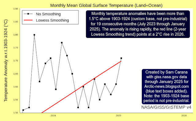
The image below illustrates the threat that the temperature rise may exceed 3°C. The blue trend, based on January 1880 to March 2023 data, shows how 3°C could be crossed in 2036. The magenta trend, based on January 2010 to March 2023 data, better reflects relatively short-term variables such as El Niño and illustrates how 3°C could be crossed as early as in 2025.


The above image uses monthly NASA Land+Ocean temperature anomalies versus 1886-1915 that are further adjusted by 0.99°C to reflect ocean air temperatures, higher polar anomalies and a pre-industral base, as also illustrated by the image below. 


What could cause the temperature rise to cross 3°C in 2025? This has been discussed in earlier posts such as this one. Briefly, such a rise could be triggered by relatively short-term variables such as the upcoming El Niño, high sunspots and extra water vapor in the atmosphere due to the eruption of a submarine volcano. Together, they could raise temperatures by more than half a degree Celsius, triggering the compound impact of further events including feedbacks kicking in with greater ferocity and tipping points getting crossed, such as the latent heat tipping point and the seafloor methane tipping point.

Indeed, rising temperatures threaten to cause massive loss of sea ice followed by eruptions of methane from the seafloor of the Arctic Ocean. This threat is further illustrated by the image below. 

Sea surface temperature

On April 29, 2023, the sea surface off the coast of South America was as much as 6.1°C or 10.9°F hotter than it was in 1981-2011, as illustrated by the image below that also shows a distorted Jet Stream that is stretched out from pole to pole (wind at 250 hPa).


Sea Surface Temperature World (60S-60N)

On April 28, 2023, the world sea surface temperature (SST between 60°South and 60°North) had been at 21°C or higher for as many as 38 days. Such temperatures are unprecedented in the NOAA record that goes back to 1981.


Recently (e.g. on April 4, 2023), the sea surface temperature in 2023 (black line) was as much as 0.3°C higher than in 2022 (orange line) on April 28, 2023, and this while we're only just entering the upcoming El Niño.

Sea Surface Temperature North Atlantic

The situation is especially critical in the North Atlantic. Last year (in 2022), North Atlantic sea surface temperatures reached a record high of 24.9°C in early September. Recently (e.g. on April 4, 2023), the North Atlantic sea surface temperature was as much as 0.5°C higher (black line) than in 2022 (orange line).


On April 28, 2023, the sea surface temperature in the North Atlantic was 20.6°C, the highest temperature for the time of year in the NOAA record that goes back to 1981. 

As we're moving into the upcoming El Niño, the Arctic Ocean can be expected to receive more and more heat over the next few years, i.e. more heat from direct sunlight, more heat from rivers, more heat from heatwaves and more ocean heat from the Atlantic Ocean and the Pacific Ocean.

Monthly Northern Hemisphere Land Temperature Anomaly

Temperatures have been rising especially fast on land in the Northern Hemisphere, where most people are living. As temperatures keep rising, more extreme weather events can be expected that can make life hard, if not impossible, even at higher latitudes.

The image below shows monthly anomalies up to March 2023, with two trends added. The blue trend, based on January 1850-March 2023 NOAA data, points at a 3°C rise in 2032. The magenta trend, based on October 2010-March 2023 NOAA data, better reflects variables such as El Niño and sunspots, and illustrates how they could trigger a rise of more than 3°C in 2024 and a rise of more than 5°C in 2026. Note that the image displays anomalies versus 1901-2000, anomalies versus pre-industrial would be significantly higher.
  
[ from earlier post ]
Greenhouse gas levels

Carbon dioxide (CO₂) broke three records recently, for the daily, weekly and monthly average. The daily CO₂ average was 425.01 ppm on April 28, 2023, the weekly CO₂ average was 424.4 ppm for the week beginning on April 23, 2023, and the monthly CO₂ average was 423.38 ppm in April 2023, each of them the highest carbon dioxide levels on record at Mauna Loa, Hawaii, as illustrated by the image below.


CO₂ typically reaches its annual high in May or June, so these records can be expected to be broken over the next few months.
[ from earlier post ]

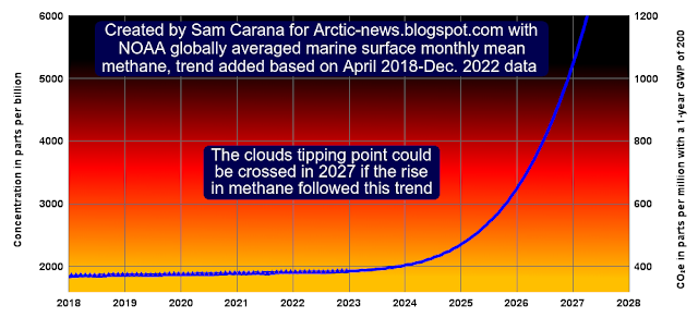
Even more crucially, methane emissions should be cut rapidly and dramatically, as discussed in an earlier post. If a trend such as the one in the above image continues, the Clouds Tipping Point could be crossed as early as in 2027 due to forcing caused by the rise in methane alone, while  this could happen even earlier than in 2027 when further forcing other than just the forcing from methane is taken into account. Crossing the Clouds Tipping Point, at 1200 ppm CO₂e, could on its own cause a further rise of 8°C. 

NOAA's 1924.99 ppb for the December 2022 global methane mean translates into 385 ppm CO₂e when using a 1-year GWP of 200 for methane.

So, adding this 385 ppm CO₂e to 425 ppm CO₂ would leave just 390 ppm CO₂e for further forcing, before the Clouds Tipping Point would get crossed, as the image on the right illustrates.

Methane at higher altitude can reach even higher levels than NOAA's global marine surface data. As illustrated by an image in an earlier post, monthly methane recently rose to above 1950 ppb at Mauna Loa, Hawaii.

Further changes such as caused by sea ice loss and changes in aerosols can also speed up the temperature rise.

El Niño and further variables

We're moving into an El Niño, as illustrated by the image on the right, adapted from NOAA.

Moving from the bottom of a La Niña to the peak of a strong El Niño could make a difference of more than half a degree Celsius, as discussed in an earlier post. El Niño can be expected to reach its full strength within a few years, with a maximum possible in 2026.

Furthermore, sunspots look set to reach a very high maximum within years, while the 2022 Tonga submarine volcano eruption did add a huge amount of water vapor to the atmosphere, as discussed in an earlier post.

In the video below, Guy McPherson gives his views.


Extinction

Vast amounts of ocean heat are moving toward the Arctic, especially in the North Atlantic, threatening to cause rapid melting of Arctic sea ice and thawing of permafrost.

The image on the right, adapted from NOAA, shows ocean heat moving toward the Arctic along the path of the Gulf Stream. 

Rising temperatures of the water in the Arctic Ocean threaten to trigger massive loss of sea ice (and loss of albedo) and eruptions of methane from the seafloor of the Arctic Ocean, as has been described many times before, such as in this post, in this post and in this post.

[ from earlier post ]
The above image illustrates the danger of two tipping points getting crossed, i.e. the Latent Heat Tipping Point and the Seafloor Methane Tipping Point.

Latent heat loss, feedback #14 on the Feedbacks page
[ see analysis at the Extinction page ]
Destabilization of methane hydrates at the seafloor of the Arctic Ocean threatens to result in explosive eruptions of methane, as its volume increases 160 to 180-fold when leaving the hydrates, as illustrated by the above image.

Conclusion

A huge temperature rise thus threatens to unfold over the next few years, as illustrated by the image on the right. The annual rise from pre-industrial to 2026 could be more than 18.44°C by 2026, and monthly anomalies could reach even higher.

Meanwhile, humans are likely to go extinct with a rise of 3°C and most life on Earth will disappear with a 5°C rise, as illustrated by the image below, from an analysis discussed in an earlier post.

This dire situation calls for urgent action as described in the Climate Plan. Reducing emissions alone won't be enough. Carbon also needs to be removed from the atmosphere and oceans, through re-/afforestation, through pyrolysis of biowaste with the resulting biochar (and nutrients) returned to the soil and further methods. Even with a rapid transition to clean, renewable energy, with changes to food, land use, construction and waste management, and with removal of large amounts of carbon from the atmosphere and oceans, still more action is needed.


Marine Cloud Brightening is a good idea, while many further methods may first need more surplus clean energy to be available and/or require more R&D.

Whether action will happen successfully and rapidly enough is indeed a good question, but that question shouldn't be used as an excuse to delay such action, since taking such action simply is the right thing to do.

[ image from Climate Emergency Declaration ]
Accordingly, everyone is encouraged to support and share this Climate Emergency Declaration.


Links

• NASA - customized temperature anomaly

• NOAA - Recent Daily Average Mauna Loa CO2
https://gml.noaa.gov/ccgg/trends/monthly.html

• NOAA - Weekly average CO2 at Mauna Loa
https://gml.noaa.gov/ccgg/trends/weekly.html

• NOAA - Climate Prediction Center - ENSO: Recent Evolution, Current Status and Predictions
https://www.cpc.ncep.noaa.gov/products/analysis_monitoring/lanina/enso_evolution-status-fcsts-web.pdf


• Climate Reanalyzer - Daily sea surface temperatures
https://climatereanalyzer.org/clim/sst_daily

• Pre-industrial

• Dire situation gets even more dire

• High sea surface temperature in North Atlantic

• Temperatures rising fast March 2023
https://arctic-news.blogspot.com/2023/04/temperatures-rising-fast-march-2023.html

• Sea surface temperature at record high
https://arctic-news.blogspot.com/2023/03/sea-surface-temperature-at-record-high.html

• IPCC keeps downplaying the danger even as reality strikes

• Transforming Society

• Climate Plan
https://arctic-news.blogspot.com/p/climateplan.html


Friday, October 15, 2021

Will COP26 in Glasgow deliver?


September 2021 was the second warmest September on record, after September 2020, according to NASA, Copernicus and James Hansen, despite the cooling effect of the current La Niña. Above NASA map shows that the Arctic Ocean was hit severely by high temperatures.

The NASA map shows an anomaly of 0.96°C compared to 1951-1980. With COP26 to be held in Glasgow, from October 31 to November 12, 2021, it's important to realize that using the period from 1951 to 1980 as a base is not the same as pre-industrial. So, how much has the temperature risen from pre-industrial and what are the prospects? Will COP26 deliver?

[ from earlier post ]
Let's do the calculations once more. The trend in the image below indicates that the NASA data need to be adjusted by 0.29°C to change the base from 1951-1980 to 1900. 


Of course, 1900 is still not pre-industrial. The chart below shows three trends:
  1. The green trend is based on unadjusted NASA data (1951-1980 base). 
  2. The lilac trend is based on data adjusted by 0.79°C for a 1750 base, for higher polar anomalies and for ocean air temperatures. The lilac trend shows that the 1.5°C threshold was already crossed when the Paris Agreement was adopted in 2015, while a 3°C could be crossed well before 2050.
  3. The red trend is based on data adjusted by 1.28°C, adding an extra 0.49°C to the lilac data for a 3480 BC base. The red trend shows that the 2°C threshold was already crossed when the Paris Agreement was adopted in 2015, while a 5°C anomaly could crossed by 2060.

The way these adjustments are calculated is also discussed in an earlier post and at the pre-industrial page.

Another thing to consider is the impact of short-term variables. The chart below shows the same red data, i.e. 1.28°C adjusted, with two trends added: a red trend based on 1880-Sept. 2021 data, and a blue trend based on 2015-Sept. 2021 data.


The blue trend is more in line with short-term variables, such as El Niño, sunspots and volcanoes. The blue trend shows that temperatures are currently suppressed.

Within a few years time, sunspots can be expected to reach the peak of their current cycle, and they are looking stronger than forecast, as illustrated by the image on the right, adapted from NOAA.

Furthermore, the next El Niño could raise surface temperatures significantly. The image below indicates that the difference between the top of El Niño and the bottom of La Niña could be more than half a degree Celsius.

As the image on the right shows, NOAA expects the current La Nina to deepen and to continue well into 2022. 

The threatening situation is that we'll go into the next El Niño, while sunspots are increasing and while the aerosol impacts may go from dimming into further driving up temperatures. A huge temperature rise could occur as the sulfates fall away that are currently co-emitted by traffic and industry, while at the same time releases of other aerosols such as black and brown carbon can increase dramatically as more wood burning and forest fires take place.

Such short-term natural variability can furthermore act as a catalyst, causing numerous feedbacks to kick in with ever greater ferocity.


Such feedbacks can result in collapse of Arctic sea ice and eruption of huge quantities of carbon dioxide, methane and nitrous oxide, further driving up the temperature rise abruptly, as illustrated by the blue trend in the image further above. 

The World Meteorological Organization (WMO) has released 2020 figures for carbon dioxide (CO₂), which reached 413.2 parts per million (ppm) in 2020, 149% of the 1750 level. Methane (CH₄) reached 1889 parts per billion (ppb) in 2020, 262% of the 1750 level and nitrous oxide (N₂O) reached 333.2 ppb, 123% of the 1750 level.

“The last time the Earth experienced a comparable concentration of CO₂ was 3-5 million years ago, when the temperature was 2-3°C warmer and sea level was 10-20 meters higher than now”, said WMO Secretary-General Prof. Petteri Taalas.

Sadly, the IPCC appears to have dramatically underplayed the gravity of the situation. The image on the right, from James Hansen, shows the gap between RCP 2.6 and added forcing since 1990.

The image below, from Tian et al. (2020), shows differences between the RCP and SSP pathways for nitrous oxide.


[ from earlier post ]
The image on the right, from an earlier post, illustrates the rise in nitrous oxide levels up April 2020.

Perhaps even more frightening is the situation regarding methane, as illustrated by the combination image below. The MetOp-2 satellite recorded some terrifying methane levels recently. On October 14, 2021 pm, a peak methane level of 4354 ppb was recorded at 293 mb (left panel), while a mean level of 2068 ppb was recorded at 367 mb (right panel). The images show only a partial cover of the globe, so there may be some problems with this satellite, yet it could be an ominous sign of things to come.


No images were available for the MetOp-2 satellite the next day, October 15, 2021. Further complicating things, no images were available for two further satellites either, the SNPP satellite and the NOAA 20 satellite. 


Very few methane measurements are available for the Arctic. Measurements are available from only a handful of ground stations, i.e. flask and in situ data at Barrow, Alaska, and flask data at Cold Bay, Alaska, at Ny-Alesund, Svalbard, at Alert, Nunavut, and at Summit, Greenland, while one-off measurements have been taken by vessels and by aircraft, such as at Poker Flats, near Fairbanks, Alaska. Availability of flask data stopped in 1997 at Mould Bay, Northwest Territories, and in 2018 at Tiksi, Russia. Moreover, to monitor methane releases from the seafloor of the Arctic Ocean, it is essential to have more continuous measurements taken at numerous altitudes by polar-orbiting satellites. And of course, taking measurements alone is not enough to reduce the danger.

Meanwhile, NOAA has put up a notice that IASI data and products from Metop-A (MetOp-2) will no longer update and the satellite will be retired on November 15, 2021.

Data from the MetOp-1 satellite are still available. The animation on the right shows methane as recorded by the MetOp-1 satellite on October 16, 2021 pm from 972 mb (roughly sea level) to 766 mb (some 2.3 km or 7,546 ft).

The magenta color indicates the highest methane levels. The animation shows that magenta-colored areas (with the highest levels) first show up over the Arctic Ocean, close to sea level. When rising up further toward the Tropopause, beyond what the animation shows, even more magenta shows up, with methane moving toward the Equator, as the Tropopause is higher closer to the Equator. 

The image on the right shows the situation on October 25, 2021 am at 295 mb, which is at an altitude of about 9 km (5.592 miles), where the tropopause starts over the North Pole. 

The image shows that the mean global methane level at this altitude was 1958 ppb. Very high methane levels show up over the high Arctic, as indicated by the magenta color. The image further shows the strong accumulation of methane at this altitude.

Below is an image by Copernicus, showing methane at 500 hPa on October 16, 2021 at 03 UTC. 


As said, the IPCC sadly keeps downplaying the temperature rise and the threat of a huge rise soon, while promoting the idea that there was a “carbon budget” to be divided among polluters that would enable polluters to keep polluting for decades to come. Hopefully, politicians at COP26 will do the right thing. The situation is dire and calls for the most comprehensive and effective action, as described at the Climate Plan.


Links

• NASA GISS Surface Temperature Analysis (GISTEMP v4)
https://data.giss.nasa.gov/gistemp/

• Glasgow Climate Change Conference (COP26)
https://unfccc.int/process-and-meetings/conferences/glasgow-climate-change-conference

• IPCC special report on the impacts of global warming of 1.5 °C above pre-industrial levels and related global greenhouse gas emission pathways (SR1.5)
https://report.ipcc.ch/sr15/

• IPCC AR6
https://www.ipcc.ch/assessment-report/ar6/

• Paris Agreement, adopted 2015
https://unfccc.int/sites/default/files/resource/docs/2015/cop21/eng/l09r01.pdf
https://arctic-news.blogspot.com/2015/12/paris-agreement.html

• WMO - Greenhouse Gas Bulletin: Another Year Another Record
https://public.wmo.int/en/media/press-release/greenhouse-gas-bulletin-another-year-another-record
https://library.wmo.int/index.php?lvl=notice_display&id=21975

• MetOp satellites
https://www.ospo.noaa.gov/Products/atmosphere/soundings/iasi/

• Copernicus - methane
https://atmosphere.copernicus.eu/charts/cams/methane-forecasts

• September Temperature Update & COP 26 - 14 October 2021 - by James Hansen and Makiko Sato

• NOAA Sunspots

• A comprehensive quantification of global nitrous oxide sources and sinks - by Hanqin Tian et al. (2020)
https://www.nature.com/articles/s41586-020-2780-0

• NOAA - ENSO: Recent Evolution, Current Status and Predictions - October 11, 2021
https://arctic-news.blogspot.com/2021/08/is-the-ipcc-creating-false-perceptions-again.html

• Pre-industrial

• Feedbacks
https://arctic-news.blogspot.com/p/feedbacks.html

• Climate Plan
https://arctic-news.blogspot.com/p/climateplan.html

Friday, February 12, 2021

The extreme rate of global warming: IPCC Oversights of future climate trends

by Andrew Glikson

Intergovernmental Panel on Climate Change (IPCC) reports and comprehensive summaries of the peer-reviewed literature raise questions regarding the assumptions inherent in computer modelling of future climate changes, including the supposed linearity of future global temperature trends (Figure 1).

Figure 1. Global mean surface temperature increase as a function of cumulative total global carbon dioxide (CO2) emissions from various lines of evidence. IPCC

Computer modelling does not necessarily capture the sensitivity, complexity and feedbacks of the atmosphere-ocean-land system as observed from paleoclimate studies. Underlying published IPCC computer models appears to be an assumption of mostly gradual or linear responses of the atmosphere to compositional variations. This overlooks self-amplifying effects and transient reversals associated with melting of the ice sheets. 

Leading paleoclimate scientists have issued warnings regarding the high sensitivity of the atmosphere in response to extreme forcing, such as near-doubling of greenhouse gas concentrations: According to Wallace Broecker, “The paleoclimate record shouts out to us that, far from being self-stabilizing, the Earth's climate system is an ornery beast which overreacts to even small nudges, and humans have already given the climate a substantial nudge”. As stated by James Zachos, “The Paleocene hot spell should serve as a reminder of the unpredictable nature of climate”.

Holocene examples are abrupt stadial cooling events which followed peak warming episodes which trigger a flow of large volumes of ice melt water into the oceans, inducing stadial events. Stadial events can occur within very short time, as are the Younger dryas stadial (12.9-11.7 kyr) (Steffensen et al. 2008) (Figure 2) and the 8.2 kyr Laurentian cooling episode,

Despite the high rates of warming such stadial cooling intervals do not appear to be shown in IPCC models (Figure 1).

Figure 2. The younger dryas stadial cooling (Steffensen et al., 2008). Note the abrupt freeze and thaw boundaries of ~3 years and ~1 year.

Comparisons with paleoclimate warming rates follow: The CO₂ rise interval for the K-T impact is estimated to range from instantaneous to a few 10³ years or a few 10⁴ years (Beerling et al, 2002), or near-instantaneous (Figure 3A). An approximate CO₂ growth range of ~0.114 ppm/year applies to the Paleocene-Eocene Thermal Maximum (PETM) (Figure 3B) and ~0.0116 ppm/year to the Last Glacial Termination (LGT) during 17-11 kyr ago (Figure 3C). Thus the current warming rate of 2 to 3 ppm/year is about or more than 200 times the LGT rate (LGT: 17-11 kyr; ~0.0116 ppm/yr) and 20-30 times faster than the Paleocene-Eocene Thermal Maximum (PETM) rate of ~0.114 ppm/year.

Therefore the term “climate change” for the extreme warming reaching +1.5°C over the continents and more than +3°C over the Arctic over a period of less than 100 years, requires reconsideration.

However, comparisons between the PETM and current global warming may be misleading since, by distinction from the current existence of large ice sheets on Earth, no ice was present about 55 million years ago.

Figure 3. (A) Reconstructed atmospheric CO₂ variations during the Late Cretaceous–early Tertiary, based on -
Stomata indices of fossil leaf cuticles calibrated using inverse regression and stomatal ratios (Beerling et al. 2002);
(B) Simulated atmospheric CO₂ at and after the Palaeocene-Eocene boundary (after Zeebe et al., 2009);
(C) Global CO₂ and temperature during the last glacial termination (After Shakun et al., 2012) (LGM - Last Glacial Maximum; OD – Older dryas; BA - Bølling–Alerød; YD - Younger dryas)

Observed climate complexities leading to the disturbance of linear temperature variations include:
  1. The weakening of climate zone boundaries, such as the circum-Arctic jet stream, allowing cold air and water masses to shift from polar to mid-latitude zones and tropical air masses to penetrate polar zones (Figure 4), induce collisions between air masses of contrasted temperatures and storminess, with major effects on continental margins and island chains.

  2. Amplifying feedbacks, including release of carbon from warming oceans due to reduced CO₂ solubility and therefore reduced intake from the atmosphere, release of methane from permafrost and from marine sediments, desiccated vegetation and extensive bush fires release of CO₂.

  3. The flow of cold ice melt water into the oceans from melting ice sheets—Greenland (Rahmstorf et al., 2015) and Antarctica (Bonselaer et al., 2018)—ensuing in stadial cooling effects, such as the Younger dryas and following peak interglacial phases during the last 800,000 years (Cortese et al., 2007; Glikson, 2019).
Figure 4. Weakening and undulation of the jet stream, shifts of climate zones and penetration of air masses across the weakened climate boundary. NOAA.

In the shorter term such international targets as “zero emissions by 2050” apparently do not include the export of petroleum, coal and gas, thus allowing nations to circumvent domestic emission limits. Australia, the fifth biggest miner and third biggest exporter of fossil fuels, is responsible for about 5% of global greenhouse gas emissions.

At present the total CO₂+CH₄+N₂O level (mixing ratio) is near 500 ppm CO₂-equivalent (Figure 5). From the current atmospheric CO₂ level of above ~415 ppm, at the rise rate of 2 - 3 ppm/year, by 2050 the global CO₂ level would reach about 500 ppm and the CO₂-equivalent near 600 ppm, raising mean temperatures to near-2°C above preindustrial level, enhancing further breakdown of the large ice sheets and a further rise of sea levels.

Figure 5. Evolution of the CO₂+CH₄+N₂O level (mixing ratio)


Andrew Glikson

Dr Andrew Glikson
Earth and Paleo-climate scientist
ANU Climate Science Institute
ANU Planetary Science Institute
Canberra, Australia


Books:
The Asteroid Impact Connection of Planetary Evolution
http://www.springer.com/gp/book/9789400763272
The Archaean: Geological and Geochemical Windows into the Early Earth
http://www.springer.com/gp/book/9783319079073
Climate, Fire and Human Evolution: The Deep Time Dimensions of the Anthropocene
http://www.springer.com/gp/book/9783319225111
The Plutocene: Blueprints for a Post-Anthropocene Greenhouse Earth
http://www.springer.com/gp/book/9783319572369
Evolution of the Atmosphere, Fire and the Anthropocene Climate Event Horizon
http://www.springer.com/gp/book/9789400773318
From Stars to Brains: Milestones in the Planetary Evolution of Life and Intelligence
https://www.springer.com/us/book/9783030106027
Asteroids Impacts, Crustal Evolution and Related Mineral Systems with Special Reference to Australia
http://www.springer.com/us/book/9783319745442