Showing posts with label Gulf Stream. Show all posts

Friday, March 18, 2022

Signs of the rise to come

Arctic sea ice extent has fallen strongly over the past few weeks and looks set to keep falling rapidly over the next few months. 


Ocean heat is at record levels, as illustrated by the image below and as discussed in an earlier post


The image below shows the temperature at the North Pole reaching 0.7°C or 33.3°F (at 1000 hPa, at the green circle) on March 16, 2022, with ocean currents depicted at the background.


How could the temperature at the North Pole get this high, in March? 

As said, ocean heat is at record levels. This is heating up the air over the Atlantic Ocean. At times, huge amounts of heat are getting pushed into the Arctic due to a distorted Jet Stream. The image on the right shows the Jet Stream on the Northern Hemisphere on March 16, 2022, with strong winds at 250 hPa pushing heat from the Atlantic Ocean into the Arctic.

Furthermore, the Gulf Stream is pushing huge amounts of ocean heat toward the Arctic. 

The image below shows that sea surface temperatures were as much as 14.1°C or 25.3°F higher than 1981-2011 off the North American coast (green circle) on March 5, 2022.


The image below shows that, on March 16, 2022, the temperature in the Arctic was 3.5°C higher than 1979-2000. 


Below, a Climate Reanalyzer forecast for March 18, 2022, of very high temperature anomalies over Antarctica combined with a forecast of a diversion over Antarctica of the Southern Polar Jet Stream (wind at 250 hPa).


As the combination image below shows, the temperature on Antarctica was 12.5°C or 54.4°F at 1000 hPa at the green circle on March 17, 2022 at 17:00 UTC. The image in the left panel shows high sea surface temperature anomalies south of Australia, while the Jet Stream (250 hPa) moves over Antarctica. The image in the right panel shows wind and temperature at 1000 hPa. 


What causes such distortions of the Jet Stream?

• Emissions by people heat up the air, and heat up oceans and make winds stronger, as discussed in an earlier post.

• Another mechanism affecting the Jet Stream is that, as oceans heat up, the temperature difference between land and oceans widens both in Summer and in Winter and this can cause the Jet Stream to divert deeper from the narrow path it used to follow, as discussed in an earlier post

• What especially affects the Jet Stream on the Northern Hemisphere is that, as the Arctic gets hit hard by temperature rises, the temperature difference narrows between the Arctic and the Equator, slowing the Jet Stream; this can prolong and amplify extreme weather events.


Signs of the things to come

The above events could be seen as signs of the strength and the speed of the rise to come.  


Rise due to La Niña and high sunspots

The image below indicates that the global temperature difference between the top of an El Niño and the bottom of a La Niña period could be more than half a degree Celsius.


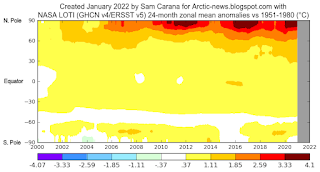
The highest temperature anomalies have over the years shown up at the highest latitudes North, i.e. the Arctic Ocean, in particular during El Niño periods.

This is illustrated by the image on the right, created with a NASA image that shows temperature anomalies of up to 4.1°C (versus 1951-1980) over the Arctic Ocean.

The next image on the right, by Climate Reanalyzer, illustrates that very high temperature anomalies can show up at the highest latitudes North during Winter on the Northern Hemisphere, in this case a temperature anomaly (vs 1979-2000) of 7°C for the Arctic as a whole on February 28, 2022. 

It is ominous for such high anomalies to show up in the Arctic during a La Niña period, and when it's Winter on the Northern Hemisphere when there's only very little sunlight reaching the Arctic. 

For comparison, the next image on the right shows a temperature anomaly (vs 1979-2000) of 7.7°C for the Arctic as a whole on November 18, 2016, when there was an El Niño. 

We're currently in the depth of a persistent La Niña, as illustrated by the next image on the right, adapted from NOAA. This has been suppressing the temperature and it will keep suppressing the temperature until the start of the next El Niño. The next El Niño could push temperatures up even more strongly than the average El Niño, for a number of reasons.

As the temperature keeps rising, ever more frequent strong El Niño events are likely to occur, as discussed in an earlier post. Furthermore, a 2019 study analyzes how tipping the ENSO into a permanent El Niño can trigger state transitions in global terrestrial ecosystems, as mentioned in an earlier post.

Currently, the temperature rise is additionally suppressed by low sunspots. Within a few years time, sunspots can be expected to reach the peak of their current cycle. Observed sunspots look stronger than predicted, as described at the sunspots page. According to IPCC AR4, warming by solar irradiance ranges from 0.06 to 0.3 W/m².


Rise due to further elements
[ from the Extinction page ]
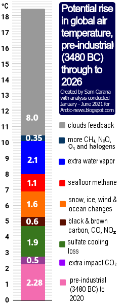
On top of the temperature rise that can be expected to unfold over the next few years due to variables such as an upcoming  El Niño and high sunspots, there is the temperature rise due to further elements.

One of these elements causing the temperature to rise is the falling away of sulfate aerosols, while there could be a further temperature rise due to releases of other aerosols that have a net warming impact, such as black and brown carbon, which can increase dramatically as more wood burning and forest fires take place.

As the temperature of the atmosphere rises, this will trigger self-reinforcing feedbacks such as an increase in water vapor combined with a decrease in lower clouds decks, further increasing the temperature, as described at the clouds feedback page.

What could further push up temperatures a lot over the next few years is the compound impact of feedbacks in the Arctic, including decline of the snow and ice cover, releases of greenhouse gases from degrading subsea and terrestrial permafrost, and further distortion of the Jet Stream causing more extreme weather events.


Conclusion

The situation is dire and calls for the most comprehensive and effective action, as described at the Climate Plan.


Links

• Albedo loss in Antarctica
https://arctic-news.blogspot.com/2022/02/albedo-loss-in-antarctica.html

• NSIDC - Charctic interactive Sea Ice Graph
https://nsidc.org/arcticseaicenews/charctic-interactive-sea-ice-graph

• Nullschool.net
https://earth.nullschool.net

• Climate Reanalyzer
https://climatereanalyzer.org

• Accelerating loss of global snow and ice cover
https://arctic-news.blogspot.com/2022/02/accelerating-loss-of-global-snow-and-ice-cover.html

• Why stronger winds over the North Atlantic are so dangerous

• NOAA - ENSO: Recent Evolution, Current Status and Predictions
https://www.cpc.ncep.noaa.gov/products/analysis_monitoring/lanina/enso_evolution-status-fcsts-web.pdf

• Historical change of El Niño properties sheds light on future changes of extreme El Niño - by Bin Wang et al. 
https://www.pnas.org/content/116/45/22512

• Tipping the ENSO into a permanent El Niño can trigger state transitions in global terrestrial ecosystems - by Mateo Duque-Villegas et al. 
https://esd.copernicus.org/articles/10/631/2019

• Accelerating loss of global snow and ice cover 

• Clouds feedback

• Feedbacks in the Arctic


Monday, February 7, 2022

Wake

by Malcolm Light

~ Wake represents the last chance for humanity to “Wake Up” to the extreme global extinction nightmare facing us; a Wake is also a Celtic “Death Watch” on our Planet Earth’s near term demise. ~


Above image shows the exponential increase of the Mean Global Atmospheric Temperature Anomaly in Degrees Celsius (Light 2021, Carana 2022, 2021; Carter, 2022) and the relative increase in Volume of Heat Transport and Temperature of the Gulf Stream–Svalbard Current into the Arctic Ocean (Smedsrud et al., 2021; Carter 2022). 

[ from earlier post ]
The Volume of Gulf Stream Heat Transport has increased by 30% in the last 100 years (Smedsrud et al., 2021) and is estimated to be some 33.6% larger by 2030.

The Gulf Stream Temperature–Heat Transport Volume Trend intersects the Mean Global Atmospheric Temperature Anomaly Trend at 2030 with an equal and combined Arctic Atmospheric and Ocean Temperature of 11.7°C.

By this time the sub-sea Arctic shelf edge methane hydrates will be exponentially destabilizing, releasing vast volumes of methane gas into the Arctic Ocean, and this will convert the sea into a ‘Methane Bubble Foam’, vastly increasing the rate of evaporation of Arctic Ocean water.

By the Northern Summer of 2035, the Arctic Ocean and Mean Global Atmospheric Temperature Anomaly will together have reached 107.5°C and will pass 117.4°C by the Northern Summer of 2036.

After 2035, the loss of the Planet's ocean water will occur at an exponential rate, as the Ocean and Mean Global Atmospheric Temperature Anomalies rise in unison and convert Earth into a high temperature, uninhabitable planet like Venus.

[ from earlier post ]

It is completely self-evident that if the Gulf Stream heat transport to the Arctic Ocean is not immediately stopped, it will cause a Catastrophic Arctic Atmospheric Global Extinction event starting in 2 to 5 years culminating around 2030 (8 Years hence) (Light 2021; Carana 2022, 2021; Carter 2022).

[ Created by Sam Carana with nullschool.net ]
Because of the very short time now left to the start of the Catastrophic Global Extinction Event, the Gulf Stream heat transport to the Arctic Ocean must be stopped.

The animation on the right shows that, on February 2, 2022, sea surface temperatures off the coast of North America were as much as 11.2°C higher than 1981-2011 (at green circle).

Present data indicates that the Mean Global Atmospheric Temperature Anomaly will have reached 5°C in the Summer of 2024 when massive Global extinction will begin in earnest. Therefore the latest date for effective action is the summer of 2023.


References

• Terrifying Arctic Methane Levels - by Sam Carana (2022)
https://arctic-news.blogspot.com/2021/12/terrifying-arctic-methane-levels.html

• Terrifying Arctic greenhouse gas levels continue - by Sam Carana (2022)
https://arctic-news.blogspot.com/2022/01/terrifying-arctic-greenhouse-gas-levels-continue.html

• Will COP26 in Glasgow deliver? - by Sam Carana (2021)

• Climate change: Satellites map huge methane plumes from oil and gas (BBC, 2022)

• Global assessment of oil and gas methane ultra-emitters - by Thomas Lauvaux et al. (2022)

• Nordic Seas Heat Loss, Atlantic Inflow, and Arctic Sea Ice Cover Over the Last Century - by Lars Smedsrud et al. (2021)
https://agupubs.onlinelibrary.wiley.com/doi/10.1029/2020RG000725

• The Gulf Stream has increased steadily over the last century - by University of Bergen (News Release associated with above study, 2022)
https://www.uib.no/en/climateenergy/150992/gulf-stream-has-increased-steadily-over-last-century

• Carter, Peter; 2022.
The 2021 Temperature Increase (1.1°C to 1.2°C) makes the Past Seven Years the Warmest on Record. Note Rapid Surface Heating of North America from Copernicus.

• Carter, Peter; 11 January 2022.
Arctic Sea Surface Temperature is Increasing at a Rate Far Above the Very Worst Case. 

• Carter, Peter; 5 January 2022. 
Through 2021 Global Warming Atmospheric Greenhouse Gases have the Planet Headed to Catastrophic Heating. 

• Hampton, Steve 2021. 
Modern climate change is 10x faster than historic global warming mass extinction events

• Light M.P.R., 2021. 
Planetary Extinction due to Arctic Atmospheric Methane Veil

• Light M.P.R., 2015. 
Planetary Genocide - Ecocide between 2023 and 2031
https://arctic-news.blogspot.com/2015/01/planetary-genocide-ecocide-between-2023-and-2031.html

• Light M.P.R., Hensel H. and Carana S., 2014. 
Arctic Atmospheric Methane Global Warming Veil

• Light M.P.R., 2013. 
Act now on methane (extract)
Act now on methane (full version)
https://sites.google.com/site/runawayglobalwarming/the-non-disclosed-extreme-arctic-methane-threat

• Light M.P.R., 2012. 
Global extinction within one human lifetime as a result of a spreading atmospheric methane heatwave and surface firestorm 
https://arctic-news.blogspot.com/p/global-extinction-within-one-human.html

• Light M.P.R., 2012. Edited by Sam Carana. 
How much time is there left to act, before methane hydrate releases will lead to human extinction?

• Light M.P.R., 2011. Edited by Sam Carana. 
Use of beamed interfering radio frequency transmissions to decompose Arctic atmospheric methane clouds. 

• Light M.P.R., 2011. 
Stratospheric methane global warming veil

• Light M.P.R. and Solana C., 2002. 
Arctic Methane Hydrates: A Potential Greenhouse Gas Hazard

• Light M.P.R. and Solana C., 2002. 
Arctic methane hydrates - Mapping a potential greenhouse gas hazard. Abstract and Poster, EGS, Nice. In: Light, M.P.R. and Carana, S., 2011. Methane linked to Seismic Activity in the Arctic

• Light M.P.R. and Posey, H.H., 1992. 
Chapter 10 Diagenesis and its Relation to Mineralization and Hydrocarbon Reservoir Development: Gulf Coast and North sea Basins

• Light M.P.R., Posey, H.H., Kyle, J.R., and Price P.E., 1987. 
Integrated hydrothermal model for the Texas Gulf Coast Basin; origins of geopressured brines and lead-zinc, uranium, hydrocarbon, and cap rock deposits

• Light M.P.R., Posey, H.H., Kyle, J.R., and Price P.E., 1987. 
Model for the origins of geopressured brines, hydrocarbons, cap rocks and metallic mineral deposits: Gulf Coast, U.S.A.. In: Lerch, Ian, and O'Brien, J.J., Dynamical geology of salt and related structures: Orlando, Florida, Academic Press, pp. 787-830

• Light M.P.R., 1985. 
Structure, facies, continuity and internal properties of the Frio "A" sandstone, N.E. Hitchcock Field, Galveston County, Texas. In: Dorfman, M.H. and Morton, R.A. eds., Geopressured-Geothermal Energy, Proceedings of the Sixth U.S. Gulf Coast Geopressured-Geothermal Energy Conference: Pergamon, p. 229 - 238.


Wednesday, April 5, 2017

Gulf Stream is heating up

El Niño 2017 is strengthening. On March 24, temperatures in Africa were as high as 50.6°C or 123°F.


The image below shows wildfires hitting Northern China and Far East Russia on April 4, 2017. The Amur River, which forms the boundary between China and Russia, is visible on this Terra/MODIS satellite image, with red dots indicating wildfires.


Emissions associated with such wildfires can be huge, as illustrated by the image below. On April 4, 2017, sulfur dioxide (SO₂) levels were as high as 766.29 µg/m³ at a spot (marked by the green circle, left panel) north of the Amur River, in Russia, while carbon dioxide (CO₂) levels were as high as 513 parts per million at that same spot and carbon monoxide (CO) levels there were as high as 17,402 parts per billion.


These high sulfur dioxide levels indicate that sulfur that has over the past few decades been deposited there from smokestacks of coal-fired power plants, tailpipes of vehicles, etc., can re-enter the atmosphere as a result of wildfires, confirming the conclusion of earlier studies such as by Hegg et al.

This indicates that sulfur levels in the atmosphere are higher than previously estimated, given that most previous estimates were mainly based on real-time emissions from industrial activity at the time. When adding revolitalization of previously-deposited sulfur (due to wildfires) into the picture, estimates for such aerosols' masking effect of the full wrath of global warming will be higher than previously thought, and increasingly so, as wildfires are becoming painfully more common as Earth continues to warm up.

This also implies that it becomes increasingly plausible that, when aerosol levels suddenly drop during heatwaves, wet bulb temperature starts crossing sustainability limits for humans without air-conditioning. Note that in July 2016, weather conditions at a spot in the U.S. came perilously close to this limit.

What could further contribute strongly to a rapid rise in global temperature is the combination of decline of Earth's snow and ice cover and eruptions of methane from the seafloor of the Arctic Ocean.

The Gulf Stream is heating up as the 2017 El Niño strengthens, fueled by record low global sea ice extent, which means that a lot of extra heat is getting absorbed globally (image below, by Wipneus).


Both Arctic and Antarctic sea ice extent were are record low on April 1, 2017, as the images below show.

Sea surface temperatures were as much as 5.9°C or 10.6°F warmer than 1981-2011 at the location marked by the green circle on the image below.


Over the next half year, increasingly warm waters will be carried by the Gulf Stream from the coast of North America to the Arctic Ocean. As this warmer water arrives in the Arctic Ocean, there will no longer be a large buffer of sea ice there to consume the heat, as was common for the past thousands of years and longer. Additionally, warmer water looks set to arrive in an Arctic Ocean that will be heated up like we've never seen before, as so much of the sunlight reaching the surface of the Arctic Ocean doesn't get reflected back into space anymore and as temperatures again look set to reach record highs in the Arctic during the northern summer.

Where can all this extra heat go? Sea ice will start sealing off much of the surface of the Arctic Ocean by the end of September 2017, making it hard for more heat to escape the Arctic Ocean by entering the atmosphere. The extremely dangerous situation is that it looks like much of the extra heat will instead reach sediments at the seafloor of the Arctic Ocean that contain huge amounts of methane in currently still frozen hydrates.


An image in an earlier post showed many cracks in the sea ice north of Greenland. Above image shows that huge cracks are also present in the sea ice in the Beaufort Sea.


On the combination images above and below, high concentrations of methane show up all over the Arctic Ocean, specifically over the Beaufort Sea and over and around Greenland. Note also the methane showing up over Antarctica, as discussed in an earlier post.


The situation is dire and calls for comprehensive and effective action, as described at the Climate Plan.


Links

• Climate Plan
https://arctic-news.blogspot.com/p/climateplan.html

• Extinction
https://arctic-news.blogspot.com/p/extinction.html

• How much warming have humans caused?
https://arctic-news.blogspot.com/2016/05/how-much-warming-have-humans-caused.html

•Earth losing her sea ice
https://arctic-news.blogspot.com/2017/03/earth-losing-her-sea-ice.html

• Methane Erupting From Arctic Ocean Seafloor
https://arctic-news.blogspot.com/2017/03/methane-erupting-from-arctic-ocean-seafloor.html

• Nitrogen and sulfur emissions from the burning of forest products near large urban areas, Hegg et al. (1987)
http://onlinelibrary.wiley.com/doi/10.1029/JD092iD12p14701/full

• Warning of mass extinction of species, including humans, within one decade
https://arctic-news.blogspot.com/2017/02/warning-of-mass-extinction-of-species-including-humans-within-one-decade.html

• Low sea ice extent contributes to high methane levels at both poles


Monday, February 15, 2016

Arctic sea ice remains at a record low for time of year

For the time of year, Arctic sea ice remains at a record low since satellite records started in 1979, both for area and extent. The image below shows Arctic sea ice area up to February 12, 2016, when area was 12.49061 million square km.


The image below shows Arctic sea ice extent up to February 12, 2016, when extent was 14.186 million square km.


The reason for the record low sea ice is that there is more ocean heat than there used to be. The image below shows that on February 12, 2016, the Arctic Ocean sea surface temperature was as warm as 11.3°C (52.4°F) at a location near Svalbard marked by the green circle, a 10.4°C (18.7°F) anomaly.


The reason for this is that the water off the east coast of North America is much warmer than it used to be.

The Gulf Stream is pushing heat all the way into the Arctic Ocean.

The image below shows that on February 14, 2016, sea surface temperature anomalies (compared to 1981-2011) off the east coast of North America were was as high as 10.1°C or 18.1°F (at the location marked by the green circle).

While sea surface looks cooler (compared to 1981-2011) over a large part of the North Atlantic, an increasing amount of ocean heat appears to be traveling underneath the sea surface all the way into the Arctic Ocean, as discussed at this earlier post.

This spells bad news for the sea ice in 2016, since El Niño is still going strong. Temperatures in January 2016 over the Arctic Ocean were 7.3°C (13.1°F) higher than in 1951-1980, according to NASA data, as illustrated by the graph on the right.

See the Controversy page for discussion
A polynomial trend added to the January land temperature anomaly on the Northern Hemisphere since 1880 shows that a 10°C (18°F) rise could eventuate by the year 2044, as illustrated by the graph on the right. Over the Arctic Ocean, the rise can be expected to be even more dramatic.

As the NASA map below illustrates, the global January 2016 land-ocean temperature anomaly from 1951-1980 was 1.13°C (or over 2°F) and the heat did hit the Arctic Ocean stronger than elsewhere.

In January 2016, it was 1.92°C (3.46°F) warmer on land than in January 1890-1910. Before 1900, temperature had already risen by ~0.3°C (0.54°F), which makes it a joint 2.22°C (4°F) rise. On the Northern Hemisphere, the rise on land was the most profound, with over 10°C (18°F) warming occurring at the highest latitudes.


Meanwhile, methane levels as high as 2539 parts per billion (ppb) were recorded on February 13, 2016, as illustrated by the image below.


The danger is that, as the Arctic Ocean keeps warming, huge amounts of methane will erupt abruptly from its seafloor.

The situation is dire and calls for comprehensive and effective action as described at the Climate Plan.

Update: Arctic sea ice extent keeps falling. Last year (2015), maximum sea ice extent was reached on February 25. Could it be that maximum extent for this year was already reached on February 9, 2016? The image below illustrates this question. discussed further at the Arctic News group.

discuss this further at the Arctic News group


Arctic sea ice extent keeps falling. Last year (2015), maximum sea ice extent was reached on February 25. Could it be...
Posted by Sam Carana on Monday, February 15, 2016

Tuesday, September 1, 2015

Arctic Sea Ice Collapse Threatens - Update 7

The image below shows Arctic sea ice extent, with the blue dot indicating that extent for August 30, 2015, was 4.804 million square kilometers. Satellite records shows that, at this time of the year, extent was only lower in 2007, 2011 and 2012.


There are a number of reasons why sea ice looks set to decrease dramatically over the next few weeks. On above image, extent for 2015 looks set to soon cross the lines for the years 2007 and 2011, while the sea ice today is in an even worse condition than one might conclude when looking at extent alone.

Thick sea ice is virtually absent compared to the situation in the year 2012 around this time of year, as illustrated by the image below that compares sea ice thickness on August 30, 2012 (left) with August 30, 2015 (right).


Furthermore, sea surface temperatures are very high. The North Pacific, on August 31, 2015, was about 1°C (1.8°F) warmer than it was compared to the period from 1971 to 2000, as illustrated by the Climate Reanalyzer image on the right.

As the image below shows, sea surface temperature anomalies are very high around North America, both in the Pacific Ocean and in the Atlantic Ocean.

The image below shows sea surface temperatures on August 30, 2015, indicating that a huge amount of ocean heat has accumulated in the Atlantic Ocean off the coast of North America.


The Gulf Stream is carrying much of this warm water toward the Arctic Ocean. Additionally, warm water from the Pacific Ocean is entering the Arctic Ocean through the Bering Strait.


Above image below shows sea surface temperature anomalies in the Arctic as at August 31, 2015.


There still are a few weeks to go before sea ice can be expected to reach its minimum, at around half September 2015, while sea currents will continue to carry warmer water into the Arctic Ocean for months to come.

There is a strengthening El Niño, while more open water increases the chance that storms will develop that will push the last remnants of the sea ice out of the Arctic Ocean, as discussed in earlier posts such as this one. Storms can also mix warm surface waters all the way down to the seafloor, as discussed in this earlier post. Typhoons increase this danger. The above image show three typhoons in the Pacific Ocean on 30 August, 2015, and the Climate Reanalyzer image on the right shows them on September 1, 2015.

These typhoons are headed in the direction of the Arctic. The Climate Reanalyzer forecast for September 8, 2015, below shows typhoons in the Pacific Ocean close to the Arctic Ocean, as well as strong wind over the Arctic Ocean.


The situation is dire and calls for comprehensive and effective action, as discussed in the Climate Plan.

Tuesday, February 3, 2015

Watch where the wind blows

The Arctic looks set to be pummeled by strong winds on February 5, 2015, as shown by the Climate Reanalyzer forecast below.


The video below, based on Climate Reanalyzer images, watch the situation unfold over a period of 9 days


Strong winds can increase the transport of warm water into the Arctic Ocean by the Gulf Stream. The video shows strong winds repeatedly developing off the North American east coast and moving along the path of the Gulf Stream, all the way into the Arctic Ocean, all in a matter of days.

Emissions are causing greater warming of the Gulf Stream and the Arctic. As a result, there is less temperature difference between the equator and the Arctic, slowing down the speed at which the jet streams circumnavigate the globe, while the jets can also become wavier, which in turn can cause extreme weather events.

In this case, what fuels these winds is the temperature difference between an area off the east coast of North America where temperatures are much higher than they used to be on the one hand, and an area in Siberia where temperatures are extremely low on the other hand. Wind flows from a warm area to a cold area, and the greater the temperature difference, the stronger the wind will blow.

The image below shows that, on February 3rd, 2015, a sea surface temperature of 21°C (69.8°F) was recorded off the east coast of North America (green circle), which constitutes a 12°C (21.6°F) anomaly. Anomalies as high as 12°C were also recorded on February 4, 2015.

click on image to enlarge
Changes to the jet streams can thus fuel strong winds, and such winds can bring warmer air into the atmosphere over the Arctic Ocean. On February 5, 2015, surface temperatures over a large part of the Arctic Ocean were more than 20°C (36°F) warmer compared to what they were from 1985 to 1996.


Extreme weather events, as a result of changes to the jet streams and polar vortex, are depicted as feedback #19 in the diagram below, while storms that bring warmer air into the atmosphere over the Arctic Ocean are depicted as feedback #5,

Besides increasing the transport of warm water into the Arctic Ocean and bringing warmer air into the atmosphere over the Arctic Ocean, strong winds can also break up the sea ice by sheer brute force of the waves caused by the wind.

Waves as high as 10.61 m (34.81 ft) were recorded south of Greenland on February 4, 2015, while waves as high as 7.05 m (23.13 ft) were recorded on the edge of the Arctic sea ice (east of Svalbard) on February 5, 2015, as shown on the combination image below.


Waves that break up the sea ice into smaller pieces can speed up melting, especially in summer. More wind also means more water evaporation, and warmer air holds more water vapor, so this can result in huge rainstorms that can rapidly devastate the integrity of the ice. Strong winds thus constitute a feedback that can result in more open waters in the Arctic Ocean (feedback #6 on the diagram below).

Furthermore, strong winds can speed up the currents that will eventually move sea ice out of the Arctic Ocean into the Atlantic Ocean (feedback #7). Wavy waters catch more sunlight than still water (feedback #8). Decline of the Arctic snow and ice cover results in more sunlight being absorbed by the Arctic, thus further heating up the water of the Arctic ocean (feedback #1).

The dual image below, with images from Climate Reanalyzer, shows high sea surface temperatures around North America and at the edges of the Arctic sea ice. This contributes to surface temperatures that are 20°C (36 °F) higher than what they used to be in Eastern Siberia. At the same time, temperatures on land elsewhere in Siberia, on the North Pole and in parts of Canada and Greenland can go down to 40 degrees below zero.


Accelerated warming of the Arctic is changing the jet streams, in turn contributing to the likelyhood that such strong winds will hit the Arctic. The high temperature difference between the hot spot off the North American east coast and the cold spot over Siberia fuels such strong winds. The dual images below show the jet stream's elongated path over Greenland. Accordingly, temperature anomalies in Greenland are reaching the top end of the scale.


The big danger is that such strong winds will warm up the Arctic Ocean and cause huge amounts of methane to erupt from its seafloor.

The image below shows that methane levels as high as 2503 ppb were recorded on January 31, 2015.


Such methane eruptions constitute yet another feedback that further contributes to warming in the Arctic. For more feedbacks, see the image below.

from:  climateplan.blogspot.com/p/feedbacks.html

The situation is dire and calls for comprehensive and effective action, as discussed at the Climate Plan blog.