Showing posts with label temperatures. Show all posts

Wednesday, June 13, 2018

High Temperatures Over Arctic Ocean In June 2018

It was 6.6°C or 44°F (at 850 hPa) over the North Pole due to hot air flowing from Siberia over the Arctic Ocean on June 13, 2018, 15:00 UTC (left panel). Earlier, temperatures as high as 7°C or 44.5°F were forecast. At the same time, the Jet stream (250 hPa) crosses the Arctic Ocean and goes circular over North Canada and Baffin Bay (right panel).


As the combination image below shows, it was as hot as 32.7°C or 90.9°F (left panel, at the green circle) on June 11, 2018, on the coast of Hudson Bay. The right panel shows the jet stream crossing the Arctic, while numerous cyclones are visible on both images.


The combination image below shows that it was as hot as 30.7°C or 87.3°F (at the green circle, left panel) on the coast of the Laptev Sea, on June 10, 2018. The right panel shows the jet stream crossing the Arctic at speeds as fast as 161 km/h or 100 mph (at the green circle).


Three ways in which heat enters the Arctic Ocean are:

1. Heat is reaching the Arctic Ocean directly, i.e. air is warming up the water of the Arctic Ocean or is melting the sea ice from above.

2. Rivers that end in the Arctic Ocean can carry huge amounts of heat.

3. Heat is also entering the Arctic Ocean from the Atlantic Ocean and the Pacific Ocean.

Feedbacks, such as changes to the jet stream, can further speed up warming of the Arctic Ocean.

As the Arctic warms up faster than the rest of the world, the temperature difference between the Arctic and the Equator decreases, making the Jet Stream wavier, with longer loops that allow more warm air to enter the Arctic and at the same time allow more cold air to flow out of the Arctic (feedback #10 on the feedbacks page).

The top image on the right shows that the sea surface in the Atlantic Ocean off the coast of North America on May 29, 2018, was as much as 9.8°C or 17.6°F warmer than 1981-2011 (at the green circle).

As temperatures keep rising, increasingly stronger winds over oceans are also causing more heat to enter the Arctic Ocean from the North Atlantic, and from the Pacific Ocean.

On June 4, 2018, the sea surface in the Pacific Ocean near Bering Strait was as much as 7.2°C or 12.9°F warmer than 1981-2011 (at the green circle), as the next image on the right shows.

The next image on the right shows that water near Svalbard was as warm as 16.1°C or 61°F on June 4, 2018, versus 3°C or 37.4°F in 1981-2011 (at the green circle).

On June 4, 2018, sea surface temperature near Svalbard was as warm as indicated by the color yellow on the image on the right, i.e. 16-18°C or 60.8-64.4°F. For more background on the warm water near Svalbard, also see the earlier post Accelerating Warming of the Arctic Ocean.

This heat will warm up the water underneath the sea ice, thus melting the sea ice from below.

Furthermore, as the sea ice retreats, more sunlight will be absorbed by the Arctic Ocean, instead of being reflected back into space, thus further speeding up sea ice decline.


Oceans take up over 90% of global warming, as illustrated by above image. Ocean currents make that huge amounts of this heat are entering the Arctic Ocean from the Pacific Ocean and the Atlantic Ocean.

The right-hand panel of the image below shows the extent of the permafrost on the Northern Hemisphere. The subsea permafrost north of Siberia is prone to melting due to the increasingly higher temperatures of the water. Increasingly high air temperatures are melting the sea ice and, where the sea ice is gone, they are warming up the water directly.


High air temperatures are also warming up the water from rivers flowing into the Arctic Ocean, as illustrated by the left panel of above image.

On June 15, 2018, it was as warm as 31.5°C or 88.6°F at 06:00 UTC and 31.7°C or 89.1°F at 09:00 UTC over the Kotuy/Khatanga River that ends in the Laptev Sea in the Arctic Ocean (green circle).

On June 20, 2018, it was even warmer, as the image on the right shows. It was as warm as 32.3°C or 90.1°F at 1000 hPa over the Yenisei River that ends in the Kara Sea in the Arctic Ocean (green circle). It was actually even warmer at surface level, but just look at the temperatures on the image over Greenland and the Tibetan Plateau at 1000 hPa. See also this post.

As the water of the Arctic Ocean keeps warming, the danger increases that methane hydrates at the bottom of the Arctic Ocean will destabilize.

Methane releases from the seafloor of the Arctic Ocean can dramatically warm up the atmosphere, especially at higher latitudes. Ominously, very high methane peaks are increasingly appearing, as high as:
- 2899 ppb on May 04, 2018, a.m.
- 2498 ppb on May 16, 2018, p.m.
- 2820 ppb on May 21, 2018, a.m.
- 2616 ppb on May 22, 2018, p.m.
- 3006 ppb on May 27, 2018, p.m.
- 2878 ppb on June 05, 2018, p.m.
- 2605 ppb on June 07, 2018, a.m.

Mean global methane level was as high as 1880 ppb on June 15, 2018, at 254 mb, further confirming that more methane is increasingly accumulating at greater heights in the atmosphere.

NOAA records show that the average May 2018 CO₂ level was 411.25 ppm at Mauna Loa, Hawaii, while the hourly average peaked at well above 416 ppm.

"CO₂ levels are continuing to grow at an all-time record rate because burning of coal, oil, and natural gas have also been at record high levels,” said Pieter Tans, lead scientist of NOAA's Global Greenhouse Gas Reference Network in a news release. "Today's emissions will still be trapping heat in the atmosphere thousands of years from now."

Greenhouse gas levels are particularly high over the Arctic Ocean. CO₂ levels were 420 ppm over the North Pole on June 12, 2018.

The situation is getting even more critical as we've left the La Niña period behind and are now moving into an El Niño period, as illustrated by the images on the right and below.

A further danger is that earthquakes can be triggered as more ice is melting on Greenland, as discussed earlier in posts such as this one and this one. Earthquakes can send out strong tremors through the sediment and shock waves through the water, which can trigger further earthquakes, landslides and destabilization of methane hydrates. The situation is especially dangerous when combined with extreme weather events that can cause cracks and movement in sediments. The image below shows earthquakes that hit the seas around Greenland between May 30, 2018, and June 17, 2018.


Given the above, it's amazing that the IPCC in its 'final draft 1.5°C report' insists that "If emissions continue at their present rate, human-induced warming will exceed 1.5°C by around 2040" (according to a recent Reuters report). The final draft is now going to governments for their scrutiny, with the danger that the dire situation may be watered down even further.

Governments should be urged to confirm that temperatures could rise dramatically over the next few years. Accordingly, comprehensive and effective action needs to be taken, as described at the Climate Plan page.


Links

• Climate Plan
http://arctic-news.blogspot.com/p/climateplan.html

• Feedbacks
http://arctic-news.blogspot.com/p/feedbacks.html

• Accelerating Warming of the Arctic Ocean
https://arctic-news.blogspot.com/2016/12/accelerating-warming-of-the-arctic-ocean.html


Tuesday, June 6, 2017

High Waves Set To Batter Arctic Ocean

High temperatures hit Pakistan end May 2017. The image below shows readings as high as 51.1°C or 123.9°F on May 27, 2017 (at green circle).


As the image below shows, sea temperature was as high as 32.6°C or 90.6°F on May 28, 2017 (at the green circle), 1.8°C or 3.2°F warmer than 1981-2011.


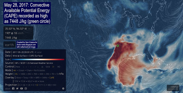
High temperatures over land and at the sea surface reflect an atmosphere that contains huge amounts of energy. On May 28, 2017, the Convective Available Potential Energy (CAPE) reached levels as high as 7448 J/kg at the location in the United States marked by the green circle. Storms hit a large part of the United States, with baseball-sized hail reported on May 27, 2017.


Here's a link to a reported 56 °C (132 °F) temperature recorded in Iran and here's a link to an article describing a May 28, 2017, reading in Turbat, Pakistan, initially reported by the Pakistan Meteorological Department as 53.5°C (128.3°F) and later upgraded to 54.0°C (129.2°F.)

How could it be possible for growth of energy in the atmosphere to be accelerating, when CO₂ emissions from fossil fuels and industry (including cement production) have barely shown any recent growth, as discussed in an earlier post and as reported by EIA?

The image on the right depicts this possibility, while a recent post discussed the following scenario:

Warmer water tends to form a layer at the surface that does not mix well with the water underneath, as discussed before. Stratification reduces the capability of oceans to take up heat and CO₂ from the atmosphere. Less take-up by oceans of CO₂ will result in higher CO₂ levels in the atmosphere, further speeding up global warming.

Additionally, 93.4% of global warming currently goes into oceans. The more heat will remain in the atmosphere, the faster the temperature of the atmosphere will rise. This feedback can cause very rapid and strong global warming. as depicted on the image on the right and as also described as feedback #29 on the feedbacks page.

With this in mind, forecasts of storms hitting the Arctic Ocean over the next few months look even more frightening.

Waves as high as 2.34 m or 7.7 ft are forecast to hit the Arctic Ocean on June 8, 2017, at the location marked by the green circle.

How is it possible for waves to get that high in a part of the Arctic Ocean that is surrounded by continents that act as shields against winds?

On June 8, 2017, temperatures are forecast to be as high as 40.6°C or 105.2°F near Phoenix, Arizona, and as high as 26.0°C or 78.7°F in Alaska, as the image below shows.


The image below shows that on June 12, 2017, temperatures as high as 35.1°C or 95.3°F were recorded over a river in Siberia that ends in the Lena River which in turn ends in the Arctic Ocean (left panel, green circle), while waves near Novaya Zemlya were recorded as high as 4.54 m or 14.9 ft (top right panel, green circle).


The image below shows that on June 6, 2017, temperatures on the coast of Hudson Bay (green circle) were as high as 31.6°C or 89°F.


Four cyclones are visible on the above image. Strong winds over the Arctic Ocean can cause high waves that can break up the sea ice and strengthen currents that are pushing warm water into the Arctic Ocean and sea ice out of the Arctic Ocean.


Update: Above image shows that on June 18, 2017, 03:00 UTC, temperatures were as high as 29.5°C or 85°F over a Siberian river ending in the Arctic Ocean (green circle). Cyclones were making warm air flow into the Arctic Ocean. The forecast for June 25, 2017, on the right shows that this situation is likely to persist for another week.

These stronger winds, currents and waves come at a time that the Arctic sea ice thickness is at record low, as illustrated by the image below on the right by Wipneus and underneath by Larry Hamilton.

Let's take a closer look at some further feedbacks that are at work behind the increasingly thinner ice, higher temperature, stronger wind and higher waves in the Arctic.

• Sea Ice Decline - The snow and ice cover over the Arctic Ocean make that sunlight is reflected back into space (albedo loss). In the absence of this cover, the Arctic Ocean will absorb more heat. Furthermore, open oceans are less efficient than sea ice when it comes to emitting in the far-infrared region of the spectrum.

• Buffer Loss - The snow and ice cover over the Arctic Ocean acts as a buffer, absorbing heat that in the absence of this buffer will have to be absorbed by the Arctic Ocean, as discussed in earlier posts such as this one.

• Jet Stream Changes - Rising temperatures in the Arctic are causing wind patterns to change, in particular the jet stream.

As a result, warm air can more easily get carried by wind from land over the Arctic Ocean.

The image on the right shows the Jet Stream on June 6, 2017. As temperatures over the Arctic rise faster than they do at the Equator, the jet stream becomes more wavy.

[ click on images to enlarge ]
Instead of circumnavigating Earth in a straight and narrow band that keeps the cold air over the Arctic separate from warmer temperatures south of the jet stream, a more wavy jet stream enables more warm air to flow into the Arctic and more cold air to leave the Arctic.

Winds are particularly strong over oceans and, as the Atlantic Ocean keeps warming up, those winds can push more warm water into the Arctic Ocean, as discussed in an earlier post. This can dramatically warm up the water of the Arctic Ocean.

• Clouds and Water Vapor - Loops of the jet stream extending over the Arctic can also bring stronger winds and more clouds and water vapor into the Arctic.

[ forecast for jet stream, June 8, 2017 ]
This is another self-reinforcing feedback that goes hand in hand with the above feedbacks. As temperatures rise in the Arctic, loss of sea ice will increase, resulting in more open water. This, in combination with stronger winds and warmer water will also result in more clouds and water vapor over the Arctic, further speeding up the temperature rise in the Arctic.

• Decline of Snow and Ice Cover on Land - Rising temperatures in the Arctic are also speeding up the decline of the snow and ice cover on land. This will result in albedo loss and will also trigger further feedbacks, such as soil destabilization and warm water from rivers flowing into the Arctic Ocean.

Soil destabilization - Heatwaves and droughts destabilize the soil. Soil that was previously known as permafrost, was until now held together by ice. As the ice melts, organic material in the soil starts to decompose and the soil becomes increasingly vulnerable to wildfires. All his can result in high emissions of CO₂, CH₄, N₂O, soot, etc., which in turn causes further warming, specifically over the Arctic. The danger of wildfires is illustrated by the image below.


• Warmer Rivers - High temperatures on land can strongly warm up water of rivers flowing into the Arctic Ocean. This is also illustrated by the above image.

• Seafloor Methane - Another huge dangers is that all this additional heat will reach the seafloor of the Arctic Ocean and will trigger destabilization of methane hydrates contained in sediments at the seafloor. Stronger winds can mix warmer water all the way down to the seafloor, and destabilize hydrates that can contain huge amounts of methane, resulting in release of huge quantities of methane into the atmosphere.

Meanwhile, an earthquake with a magnitude of 5.2 on the Richter scale hit the Greenland Sea, in between Greenland and Svalbard, on June 9, 2017 at 20:49:52 UTC at 79.931°N, 0.605°E and at 18.4 km depth. On June 12, 2017, methane levels as high as 2740 ppb were recorded, as the image below shows. While the image doesn't specify where these high levels occurred, the magenta-colored area near Greenland looks ominous, also because such high levels do not typically result from biological releases, but instead point at concentrated plumes such as can occur when clathrates get destabilized.


The situation is dire and calls for comprehensive and effective action, as described in the Climate Plan.


Links

• Climate Plan
https://arctic-news.blogspot.com/p/climateplan.html

• 10°C or 18°F warmer by 2021?
https://arctic-news.blogspot.com/2017/04/10c-or-18f-warmer-by-2021.html

• Abrupt Warming - How Much And How Fast?
https://arctic-news.blogspot.com/2017/05/abrupt-warming-how-much-and-how-fast.html

• Accelerating growth in CO₂ levels in the atmosphere
https//arctic-news.blogspot.com/2017/02/accelerating-growth-in-co2-levels-in-the-atmosphere.html

• Feedbacks
https://arctic-news.blogspot.com/p/feedbacks.html

• Warning of mass extinction of species, including humans, within one decade
https://arctic-news.blogspot.com/2017/02/warning-of-mass-extinction-of-species-including-humans-within-one-decade.html


Friday, June 5, 2015

High Temperatures in the Arctic


The images below illustrate extremely high temperatures forecast to hit Russia on June 6, 2015, as also discussed in the previous post.


A temperature of 29.4°C (84.92°F) is forecast for the location at the green circle for June 6, 2015. The location is close to the Arctic Ocean and to rivers ending in the Arctic Ocean, as also shown on the image below.


The location, at a latitude of 66.48°N, is approximately on the Arctic Circle, which runs 66°33′45.8″ north of the Equator. North of the Arctic Circle, the sun is above the horizon for 24 continuous hours at least once a year.


The many hours of sunshine make that, during the months June and July, insolation in the Arctic is higher than anywhere else on Earth, as shown on above image, by Pidwirny (2006).
Insolation, with contour labels (green) in units of W m−2

The size of the June snow and ice cover is so vitally important as insolation in the Arctic is at its highest at the June Solstice.

The Wikipedia image on the right calculates the theoretical daily-average insolation at the top of the atmosphere, where θ is the polar angle of the Earth's orbit, and θ = 0 at the vernal equinox, and θ = 90° at the summer solstice; φ is the latitude of the Earth.

The calculation assumed conditions appropriate for 2000 A.D.: a solar constant of S0 = 1367 W m−2, obliquity of ε = 23.4398°, longitude of perihelion of ϖ = 282.895°, eccentricity e = 0.016704.

Snow and ice cover on land can take up a large area, even larger than sea ice. In May 2015, the area of snow extent on the Northern Hemisphere was 17 million square km, while sea ice extent in May 2015 was below 13.5 million square km. 

Northern Hemisphere snow, May 2015. Credit: Rutgers University Global Snow Lab
The chart below shows the decline of snow cover on land on the Northern Hemisphere in Spring over the years. 

Credit: Rutgers University Global Snow Lab
High temperatures over the Arctic Ocean are heating up the snow cover on land and the sea ice from above. High temperatures also set the scene for wildfires that can emit huge amounts of pollutants, including dust and black carbon that, when settling on the sea ice, can cause its reflectivity to fall. Rivers furthermore feed warm water into the Arctic Ocean, further heating up the sea ice from below. 

The image below shows Arctic sea ice extent at June 3, 2015, when Arctic sea ice extent was merely 11.624 million square kilometers, a record low for the time of the year since satellite started measurements in 1979. 


Sea ice melting occurs due to heat from above, i.e. absorbed sunlight. Once the sea ice is gone, energy from sunlight that previously went into melting and transforming ice into water, will instead go into warming up the Arctic Ocean and the sediments under the seafloor.

In addition, sea ice is also melting due to heat from below. Much of this heat is carried by the Gulf Stream and by rivers into the Arctic Ocean. Once the sea ice is gone, all this heat will go into warming up the Arctic Ocean and the sediments under the seafloor.

The sea ice acts as a heat buffer by absorbing energy in the process of melting. In other words, as long as there is sea ice, it will absorb heat and this will prevent this heat from raising the temperature of the water in the Arctic. Once the sea ice is gone, this latent heat must go elsewhere.

As the sea ice heats up, 2.06 J/g of heat goes into every degree Celsius that the temperature of the ice rises. While the ice is melting, all energy (at 334J/g) goes into changing ice into water and the temperature remains at 0°C (273.15K, 32°F).

Once all ice has turned into water, all subsequent heat goes into heating up the water, at 4.18 J/g for every degree Celsius that the temperature of water rises.

The amount of energy absorbed by melting ice is as much as it takes to heat an equivalent mass of water from zero to 80°C. The energy required to melt a volume of ice can raise the temperature of the same volume of rock by 150º C.
Decline of Arctic sea ice means that a lot more heat will be absorbed by the Arctic Ocean.


Thick sea ice covered with snow can reflect as much as 90% of the incoming solar radiation. After the snow begins to melt, and because shallow melt ponds have an albedo (or reflectivity) of approximately 0.2 to 0.4, the surface albedo drops to about 0.75. As melt ponds grow and deepen, the surface albedo can drop to 0.15, while the ocean reflects only 6% of the incoming solar radiation and absorbs the rest.

As Professor Peter Wadhams, University of Cambridge, once calculated, a collapse of the sea ice would go hand in hand with dramatic loss of snow and ice cover on land in the Arctic. The albedo change resulting from the snowline retreat on land is similarly large as the retreat of sea ice, so the combined impact could be well over 2 W/sq m. To put this in context, albedo changes in the Arctic alone could more than double the net radiative forcing resulting from the emissions caused by all people of the world, estimated by the IPCC to be 1.6 W/sq m in 2007 and 2.29 W/sq m in 2013.

Professor Peter Wadhams on albedo changes in the Arctic

Update June 8, 2015: The website at earth.nullschool.net shows that over the past few days temperatures over 30°C (86°F) were reached at several locations over rivers ending up in the Arctic Ocean.

The animation below, by ClimateReanalyzer, shows the heat wave and the storm that hit the Arctic recently.


This animation shows the current GFS model 8-day forecast for the Arctic for six meteorological parameters (precip/cloudcover; wind, pressure, precipitable water, temperature, temperature anomaly). The forecast begins with an impressive storm twirling around the North Pole with 10-meter winds peaking around 55 km/h (~35 mi/h), which fades as the low pressure breaks down. The storm is coupled to an early season heat wave that hit Siberia this week with the development of a high amplitude ridge in the jet stream.In mid August 2012, a comparable storm churned up the sea ice and contributed to the record minimum ice extent that emerged in September. Arctic sea ice is more resilient to wind in early June when it is still relatively thick and compacted than it is in mid August towards the end of the melt season. This current storm is therefore unlikely to have the same impact as the Aug 2012 storm. But the event is worth mentioning nonetheless.

Posted by Climate Reanalyzer on Sunday, June 7, 2015


Sunday, June 29, 2014

High temperatures in the Arctic

The NOAA map below shows sea surface temperature anomalies above 8 degrees Celsius in the Arctic Ocean.


These anomalies are very high, considering that it is now June and the melting season has only just begun.

Partly causing these high temperatures in the Arctic Ocean is water flowing into the Arctic Ocean from rivers. As the map below shows, a number of large rivers flowing through Siberia end in the Arctic Ocean.

map from: http://en.wikipedia.org/wiki/File:Rs-map.png
The Naval Research Laboratory image below shows waters with very low salinity levels (top white rectangles) where warm water from rivers in Siberia enters the Arctic Ocean.


Accelerated warming of the Arctic has changed (and is still further changing) the Jet Streams, increasing the occurence of heat waves on the Norhern Hemisphere that cause huge amounts of warm water to flow into the Arctic Ocean. This is illustrated by the animation below.

Thursday, August 8, 2013

The Social Tipping Point


by Paul Beckwith

Abrupt Climate Change is happening today, big time!

Abrupt climate change. It is happening today, big time. The northern hemisphere atmospheric circulation system is doing its own thing, without the guidance of a stable jet stream. The jet stream is fractured into meandering and stuck streaked segments, which are hoovering up water vapor and directing it day after day to unlucky localized regions, depositing months or seasons worth of rain in only a few days, turning these locales into water worlds and trashing all infrastructure like houses, roads, train tracks and pipelines. Creating massive sinkholes and catastrophic landslides. And climate change is only getting warmed up.

In the Arctic methane is coming out of the thawing permafrost. Both on land and under the ocean on the sea floor. The Yedoma permafrost in Siberia is now belching out methane at greatly accelerated rates due to intense warming. The collapsing sea ice in the Arctic Ocean is exposing the open ocean to greatly increased solar absorption and turbulent mixing from wave action due to persistent cyclonic activity. Massive cyclonic activity will trash large portions of the sea ice if positioned to export broken ice via the Fram Strait.

We have lost our stable climate

What does it all mean? There is no new normal? Far from it. We have lost our stable climate. Likely permanently. Rates of change are greatly exceeding anything in the paleorecords. By at least 10x, and more likely >30x. We are heading to a much warmer world. The transition will be brutal for civilization.

Can we avoid this? Stop it? Probably not? At least with climate reality being suppressed by corporations and their government employees. With their relentless push for more and more fossil fuel infrastructure and mining and drilling.

What else can we expect as we negotiate our abrupt transition in climate to a much warmer world?

Craziness, in a nutshell. Temperatures over land surfaces in the far north have been consistently over 25 C for weeks, due to persistent high pressure atmospheric blocks leading to clear skies and unblocked solar exposure. Water temperatures in rivers and streams in the far north have resulted in large fish kills as their ecological mortality thresholds have been exceeded. Many other regions are experiencing strange incidences of animal mortality. Mass migrations of animals towards the poles are occurring on land and sea, at startling rates, in an effort for more hospitable surroundings for survival. Shifting food source distributions is causing even hardier, less vulnerable species to be severely stressed. For example, dolphins are being stranded or dying, birds are dropping out of the sky, and new parasites and bacteria are proliferating with warmer temperatures.

In regions of the world undergoing severe droughts the vegetation and soils are drying and fires are exploding in size, frequency, and severity. Especially hard-hit are large regions of the US southwest, southern Europe, and large swaths of Asia. Who knows if forests that are leveled by fire will eventually be reforested; it all depends on what type of climate establishes in the region.

What about coastal regions around the world and sea levels? Not looking too good for the home team. In 2012 Greenland tossed off about 700 Gt (Gt=billion tons) of sea ice, from both melting and calving. As the ice melts it is darkening from concentrated contaminants being exposed, from much greater areas of low albedo meltwater pools, and from fresh deposits of black carbon ash from northern forest fires. Even more worrying are ominous signs of increasing movement. GPS sensor anchored to the 3 km thick glaciers hundreds of km from the coast are registering increased sliding. Meltwater moulins are chewing through the ice from the surface to the bedrock and are transporting heat downward, softening up the ice bonded to the bedrock and allowing sliding. Eventually, large chunks will slide into the ocean causing tsunamis and abrupt sea level rises. Many regions of the sea floor around Greenland are scarred from enormous calving episodes in the past.

The Social Tipping Point

On a positive note, this knowledge of our changing climate threat is filtering out to greater numbers of the slumbering public that has been brainwashed into lethargy by the protectors of the status quo. As more and more people see the trees dying in their back yards and their cities and houses and roads buckling under unrelenting torrential rains they are awaking to the threat. And there will be a threshold crossed and a tipping point reached in human behavior. An understanding of the reality of the risks we face. And finally global concerted action. To slash emissions. And change our ways. And retool our economies and reset our priorities. And not take our planet for granted.


Paul Beckwith is a part-time professor with the laboratory for paleoclimatology and climatology, department of geography, University of Ottawa. He teaches second year climatology/meteorology. His PhD research topic is “Abrupt climate change in the past and present.” He holds an M.Sc. in laser physics and a B.Eng. in engineering physics and reached the rank of chess master in a previous life.


The above compilation of IPCC and NOAA images is by Peter Carter, who adds the following comment:
I agree. The IPCC in 2007 said: "The concentration of CO2 is now 379 parts per million (ppm) and methane is greater than 1,774 parts per billion (ppb), both very likely much higher than any time in at least 650 kyr (during which CO2 remained between 180 and 300 ppm and methane between 320 and 790 ppb). The recent rate of change is dramatic and unprecedented; increases in CO2 never exceeded 30 ppm in 1 kyr – yet now CO2 has risen by 30 ppm in just the last 17 years."

By definition this is abrupt heating. because atmospheric GHG concentration correlates directly with radiative forcing. CO2 is now 397 ppm and methane is now 1830 ppb ! It follows that the rate of ice being melted will also (as it looks) be unprecedented. The only force we have against mad fossil fuel pushing governments is accountability. They have to be made to face the full terrible consequences of their action on energy and inaction on climate. They are destroying the world.

Saturday, July 20, 2013

Watching methane over Arctic Ocean


Above image, from Wunderground.com, shows high temperatures close to the Kara Sea, where methane readings over 1950 have been recorded for some time now (see earlier posts here and here).

The image below, from Foreca and kindly provided by Albert Kallio, shows that temperatures on parts of Kara Sea and surrounding coast hit 40 degrees Celsius (or 100°F) on July 20, 2013.


The image below, also from Foreca, shows the situation on July 21, 2013, at 1:00 pm.


The NOAA image below shows sea surface temperature anomalies for July 18, 2013.


The animation below shows methane readings for July 19, 2013. High readings over the Kara Sea persist, not surprisingly, while there's a worrying spot of methane over the East Siberian Sea and there are a number of high readings showing up over Greenland. The animation below is a 3.1 MB file, so it may take some time for it to fully load.