
 |
| [ click on images to enlarge ] |
Temperatures remain extremely high, even though La Niña conditions may already be present, as illustrated by the above image, showing sea surface temperature anomalies (SSTA) versus 1981-2011.
The image on the right shows the Northern Hemisphere (-90°,90°) with SSTA as high as 24.8°F (13.8°C) in Hudson Bay (green circle) on Sep. 22, 2024. There are only very few cold spots, while massive amounts of ocean heat are present in the North Atlantic and the North Pacific.
On September 26, 2024, the sea surface temperature (60°S-60°N, 0-360°E) was 20.97°C, a record high for the time of year and 0.83°C above the 1982-2010 average, as illustrated by the image below.

North Atlantic (0-60°N 0-80°W) sea surface temperature anomalies remained high and reached a record high for the time of year on September 26, 2024, as illustrated by the image below (SSTA vs 1882-2011).

The image below shows that the North Atlantic sea surface reached a temperature of 24.97°C (76.95°F) on September 22, 2024, a record high for the time of year and 1.07°C (1.926°F) above 1991-2020 or 1.3°C (2.34°F) above 1981-2010. The image also shows a 0.23°C difference in anomalies when shifting the base by a decade, indicating that the anomaly would be much higher when calculated from a pre-industral base.

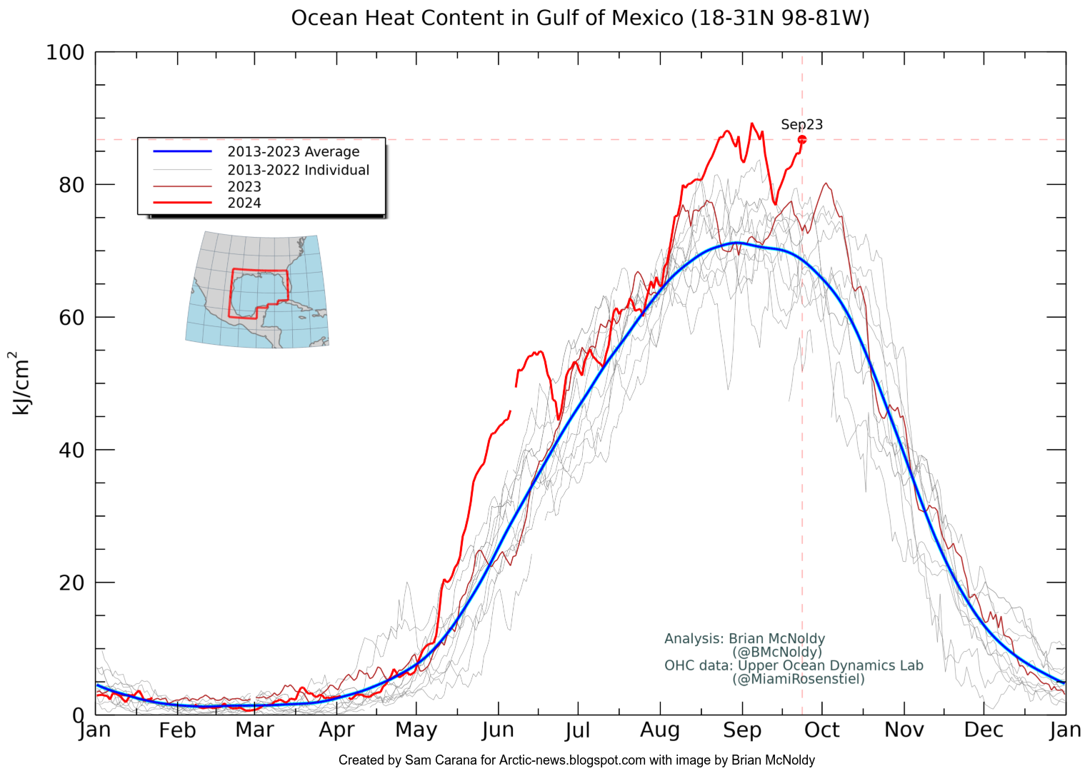
The image below, by Brian McNoldy shows that ocean heat content in the Gulf of Mexico was at a record high for the time of year on September 23, 2024.
La Niña conditions may already be present

The image below, adapted from NOAA, illustrates that El Niño conditions were present from June 2023 through April 2024, and that ENSO-neutral started in May 2024.

The danger is that we could move into a new El Niño in 2025, while sunspots move toward a peak and while temperatures remain high due to Earth's high Energy Imbalance and due to feedbacks, as discussed in a recent post. The peak in sunspots in this cycle is expected to occur in July 2025, at which time Arctic sea ice may disappear, triggering further feedbacks, leading to a huge temperature rise by end 2026 that could drive humans into extinction.


The above image illustrates that global daily mean near-surface (2m) air temperature anomalies vs 1991-2020 (Copernicus) have been above about 0.5°C for almost 16 consecutive months, i.e. since El Niño started (in June 2023, blue shade) and under ENSO-neutral conditions (starting May 2024). La Niña is expected to start October 2024 and the added trends point at a continued rise.
The danger of methane hydrates getting destabilized
 |
| [ click on images to enlarge ] |
The image on the right shows sea surface temperatures as high as 32.6°C on September 21, 2024. The image also shows the Gulf Stream pushing ocean heat toward the Arctic Ocean.
This flow of ocean heat can be accelerated by storms that are amplified due to high sea surface temperatures, deformation of the Jet Stream and a freshwater lid forming at the surface of the North Atlantic.
At the same time, Arctic sea ice starts expanding rapidly in extent at this time of year, effectively sealing off the Arctic Ocean and making it hard for heat to get transferred from the surface of the Arctic Ocean to the atmosphere.
Ocean heat that was previously consumed by melting the sea ice, can no longer get consumed by melting of the sea ice once Arctic sea ice has become very thin, and further incoming heat instead gets absorbed by the Arctic Ocean, rapidly pushing up the temperature of the water of the Arctic Ocean.
Climate Emergency Declaration
The situation is dire and the precautionary principle calls for rapid, comprehensive and effective action to reduce the damage and to improve the situation, as described in this 2022 post, where needed in combination with a Climate Emergency Declaration, as discussed at this group.

Links
• Nullschool
https://earth.nullschool.net
• Climate Reanalyzer
https://climatereanalyzer.org
• Ocean Heat Content - by Brian McNoldy
https://bmcnoldy.earth.miami.edu/tropics/ohc
• NOAA - Climate Prediction Center - ENSO: Recent Evolution, Current Status and Predictions
https://www.cpc.ncep.noaa.gov/products/analysis_monitoring/lanina/enso_evolution-status-fcsts-web.pdf
As discussed in earlier posts, Arctic sea ice has become very thin, diminishing its capacity to act as a buffer that consumes ocean heat entering the Arctic Ocean from the North Atlantic.
Sea ice constitutes a latent heat buffer, consuming incoming heat as it melts. While the ice is melting, all energy (at 334 J/g) goes into changing ice into water and the temperature remains the same. Once all ice has turned into water, all subsequent energy goes into heating up the water, and will do so at 4.18 J/g for every 1°C the temperature of the water rises.
 |
| [ The Latent Heat Buffer ] |
The danger is that, as the water of the Arctic Ocean keeps heating up, more heat will reach the seafloor and destabilize methane hydrates contained in sediments at the seafloor, resulting in eruptions of huge amounts of methane.
The image below illustrates how incoming ocean heat that previously was consumed in the process of melting of the sea ice, is now causing the water of the Arctic Ocean to heat up, with more heat reaching the seafloor of the Arctic Ocean, which has seas that in many places are very shallow.
 |
| [ Latent heat loss, feedback #14 on the Feedbacks page ] |
Eruptions from hydrates occur at great force, since the methane expands 160 times in volume when it vaporizes, resulting in the methane rapidly rising in the form of plumes, leaving little or no opportunity for microbes to decompose the methane in the water column, which especially applies to the many areas where the Arctic Ocean is very shallow. Furthermore, the atmosphere over the Arctic contains very little hydroxyl, resulting in methane persisting in the air over the Arctic much longer than elsewhere.
Climate Emergency Declaration
The situation is dire and the precautionary principle calls for rapid, comprehensive and effective action to reduce the damage and to improve the situation, as described in this 2022 post, where needed in combination with a Climate Emergency Declaration, as discussed at this group.

Links
• Nullschool
https://earth.nullschool.net
• Climate Reanalyzer
https://climatereanalyzer.org
• Ocean Heat Content - by Brian McNoldy
https://bmcnoldy.earth.miami.edu/tropics/ohc
• NOAA - Climate Prediction Center - ENSO: Recent Evolution, Current Status and Predictions
https://www.cpc.ncep.noaa.gov/products/analysis_monitoring/lanina/enso_evolution-status-fcsts-web.pdf
• NOAA - Monthly Temperature Anomalies Versus El Niño
https://www.ncei.noaa.gov/access/monitoring/monthly-report/global/202408/supplemental/page-4
• NOAA - El Niño and La Niña
https://www.noaa.gov/education/resource-collections/weather-atmosphere/el-nino
• Sunspots
https://arctic-news.blogspot.com/p/sunspots.html
• Copernicus - pulse
https://pulse.climate.copernicus.eu
• Feedbacks
https://arctic-news.blogspot.com/p/feedbacks.html
• Jet Stream
https://arctic-news.blogspot.com/p/jet-stream.html
• Freshwater lid on the North Atlantic
https://arctic-news.blogspot.com/p/cold-freshwater-lid-on-north-atlantic.html
• Latent Heat
https://arctic-news.blogspot.com/p/latent-heat.html
• Transforming Society
https://arctic-news.blogspot.com/2022/10/transforming-society.html
• Climate Plan
https://arctic-news.blogspot.com/p/climateplan.html
• Climate Emergency Declaration
https://arctic-news.blogspot.com/p/climate-emergency-declaration.html