Showing posts with label Jennifer Francis. Show all posts

Saturday, February 3, 2018

Is warming in the Arctic behind this year's crazy winter weather?

Is warming in the Arctic behind this year's crazy winter weather?

File 20180111 101511 sa3hd1.jpg?ixlib=rb 1.1
Seriously cold: The ‘bomb cyclone’ freezes a fountain in New York City.
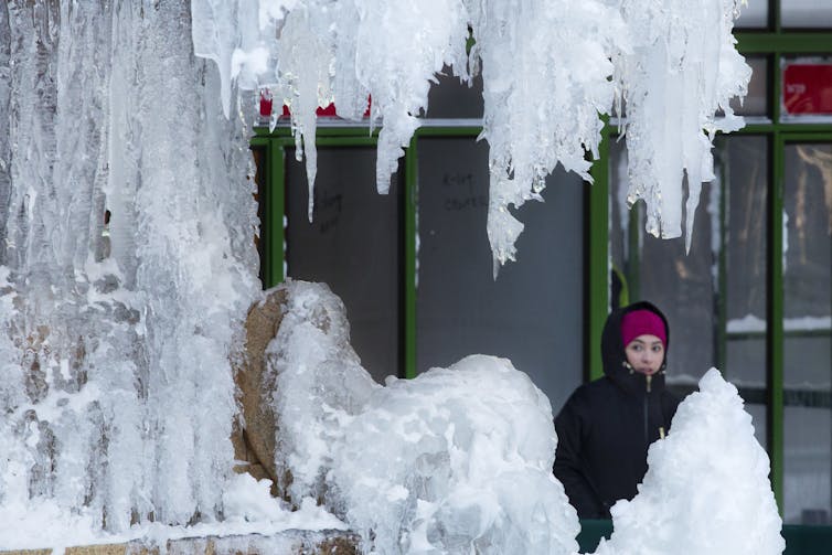
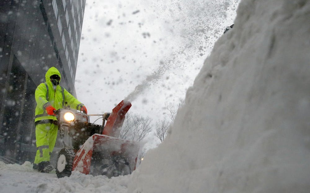
AP Photo/Mark Lennihan
Jennifer Francis, Rutgers University

Damage from extreme weather events during 2017 racked up the biggest-ever bills for the U.S. Most of these events involved conditions that align intuitively with global warming: heat records, drought, wildfires, coastal flooding, hurricane damage and heavy rainfall.

Paradoxical, though, are possible ties between climate change and the recent spate of frigid weeks in eastern North America. A very new and “hot topic” in climate change research is the notion that rapid warming and wholesale melting of the Arctic may be playing a role in causing persistent cold spells.

It doesn’t take a stretch of the imagination to suppose that losing half the Arctic sea-ice cover in only 30 years might be wreaking havoc with the weather, but exactly how is not yet clear. As a research atmospheric scientist, I study how warming in the Arctic is affecting temperature regions around the world. Can we say changes to the Arctic driven by global warming have had a role in the freakish winter weather North America has experienced?

A ‘dipole’ of abnormal temperatures

Weird and destructive weather was in the news almost constantly during 2017, and 2018 seems to be following the same script. Most U.S. Easterners shivered their way through the end of 2017 into the New Year, while Westerners longed for rain to dampen parched soils and extinguish wildfires. Blizzards have plagued the Eastern Seaboard – notably the “bomb cyclone” storm on Jan. 4, 2018 – while California’s Sierra Nevada stand nearly bare of snow.
A study in contrasts: Warming near Alaska and the Pacific Ocean are ‘ingredients’ to a weather pattern where cold air from the Arctic plunges deep into North America.
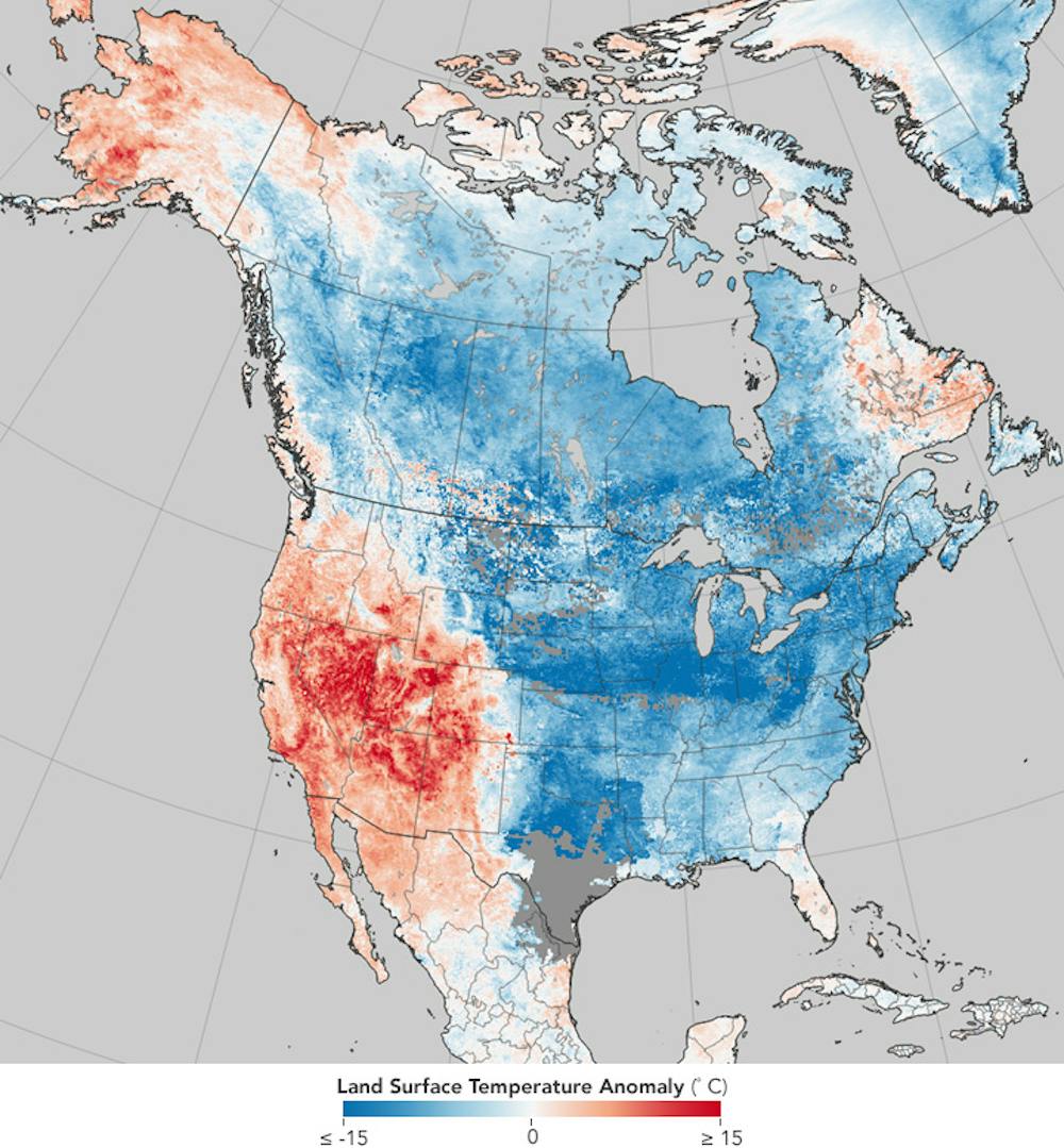
NASA Earth Observatory, CC BY
This story is becoming a familiar one, as similar conditions have played out in four of the past five winters. Some politicians in Washington D.C., including President Trump, have used the unusual cold to question global warming. But if they looked at the big picture, they’d see that eastern cold spells are a relative fluke in the Northern Hemisphere as a whole and that most areas are warmer than normal.

A warm, dry western North America occurring in combination with a cold, snowy east is not unusual, but the prevalence and persistence of this pattern in recent years have piqued the interests of climate researchers.

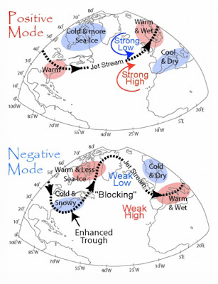
The jet stream – a fast, upper-level river of wind that encircles the Northern Hemisphere – plays a critical role. When the jet stream swoops far north and south in a big wave, extreme conditions can result. During the past few weeks, a big swing northward, forming what’s called a “ridge” of persistent atmospheric pressure, persisted off the West Coast along with a deep southward dip, or a “trough,” over the East.

New terms have been coined to describe these stubborn features: “The North American Winter Temperature Dipole,” the “Ridiculously Resilient Ridge” over the West, and the “Terribly Tenacious Trough” in the East.
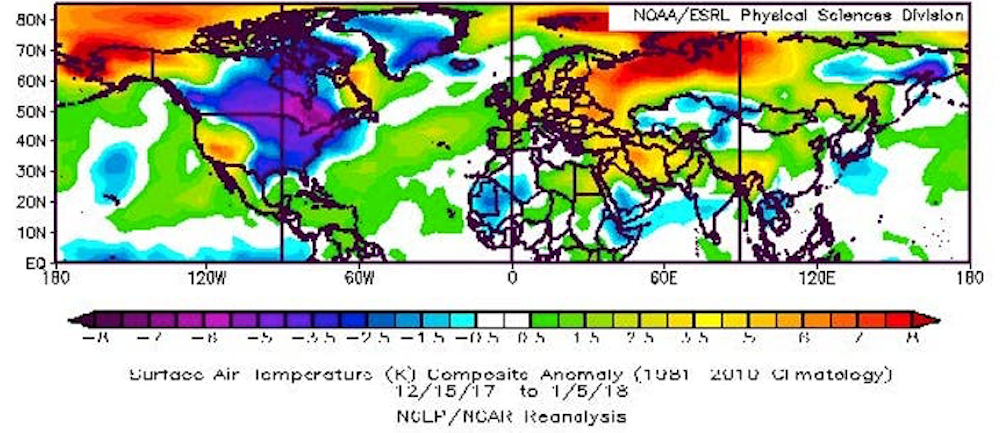
While the eastern U.S. suffered very cold temperatures in the recent cold snap, much of the rest of the Northern Hemisphere saw higher-than-average air temperatures.
NOAA, CC BY

Regardless what it’s called, this dipole pattern – abnormally high temperatures over much of the West along with chilly conditions in the East – has dominated North American weather in four of the past five winters. January 2017 was a stark exception, when a strong El Niño flipped the ridge-trough pattern, dumping record-breaking rain and snowpack on California while the east enjoyed a mild month.

Two other important features are conspicuous in the dipole temperature pattern: extremely warm temperatures in the Arctic near Alaska and warm ocean temperatures in the eastern Pacific. Several new studies point to these “ingredients” as key to the recent years with a persistent dipole.

It takes two to tango

What role does warming – specifically the warming ocean and air temperatures in the Arctic – play in this warm-West/cool-East weather pattern? The explanation goes like this.

Pacific Ocean temperatures fluctuate naturally owing to short-lived phenomena such as El Niño/La Niña and longer, decades-length patterns. Scientists have long recognized that those variations affect weather patterns across North America and beyond.
When a persistent area of atmospheric pressure stays in the western U.S., air from the Arctic pours into the U.S, causing a split between the warm and dry West and the cold East.
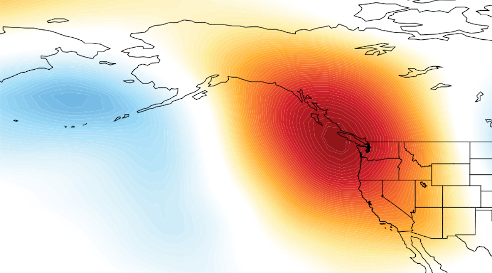
Mesocyclone2014 and David Swain, CC BY-SA

The new twist in this story is that the Arctic has been warming at at least double the pace of the rest of the globe, meaning that the difference in temperature between the Arctic and areas farther south has been shrinking. This matters because the north/south temperature difference is one of the main drivers of the jet stream. The jet stream creates the high- and low-pressure systems that dictate our blue skies and storminess while also steering them. Anything that affects the jet stream will also affect our weather.

When ocean temperatures off the West Coast of North America are warmer than normal, as they have been most of the time since winter 2013, the jet stream tends to form a ridge of high pressure along the West Coast, causing storms to be diverted away from California and leaving much of the West high and dry.

If these warm ocean temperatures occur in combination with abnormally warm conditions near Alaska, the extra heat from the Arctic can intensify the ridge, causing it to reach farther northward, become more persistent, and pump even more heat into the region near Alaska. And in recent years, Alaska has experienced periods of record warm temperatures, owing in part to reduced sea ice.

My colleagues and I have called this combination of natural and climate change-related effects “It Takes Two to Tango,” a concept that may help explain the Ridiculously Resilient Ridge observed frequently since 2013. Several new studies support this human-caused boost of a natural pattern, though controversy still exists regarding the mechanisms linking rapid Arctic warming with weather patterns farther south in the mid-latitudes.

More extreme weather ahead?

In response to the strengthened western ridge of atmospheric pressure, the winds of the jet stream usually also form a deeper, stronger trough downstream. Deep troughs act like an open refrigerator door, allowing frigid Arctic air to plunge southward, bringing misery to areas ill-prepared to handle it. Snowstorms in Texas, ice storms in Georgia and chilly snowbirds in Florida can all be blamed on the Terribly Tenacious Trough of December 2017 and January 2018.
Cold weather from the Arctic combined with warm tropical air fueled a storm that produced well over a foot of snow and spots of flooding in Boston.
AP Photo/Michael Dwyer
Adding icing on the cake is the tendency for so-called “nor’easters,” such as the “bomb cyclone” that struck on Jan. 4, to form along the East Coast when the trough’s southwest winds align along the Atlantic Seaboard. The resulting intense contrast in temperature between the cold land and Gulf Stream-warmed ocean provides the fuel for these ferocious storms.

The big question is whether climate change will make dipole patterns – along with their attendant tendencies to produce extreme weather – more common in the future. The answer is yes and no.

It is widely expected that global warming will produce fewer low-temperature records, a tendency already observed. But it may also be true that cold spells will become more persistent as dipole patterns intensify, a tendency that also seems to be occurring.

It’s hard to nail down whether this weather pattern – overall warmer winters in North America but longer cold snaps – will persist. Understanding the mechanisms behind these complex interactions between natural influences and human-caused changes is challenging.

The ConversationNevertheless, research is moving forward rapidly as creative new metrics are developed. Our best tools for looking into the future are sophisticated computer programs, but they, too, struggle to simulate these complicated behaviors of the climate system. Given the importance of predicting extreme weather and its impacts on many aspects of our lives, researchers must continue to unravel connections between climate change and weather to help us prepare for the likely ongoing tantrums by Mother Nature.

Jennifer Francis, Research Professor, Rutgers University

This article was originally published on The Conversation. Read the original article.

Monday, October 2, 2017

The Arctic is Changing the Jet Stream - Why This Is Important

By Sam Carana, with contributions by Jennifer Francis

Global warming is increasing the strength of hurricanes. A warmer atmosphere holds more water vapor and sea surface temperatures are rising. Both of these changes strengthen hurricanes. Steering winds may also be changing, causing unusual hurricane tracks such as Sandy's left turn into the mid-Atlantic seaboard and Harvey's stagnation over Houston. Is rapid Arctic warming playing a role?

Jennifer Francis has long been warning that global warming is increasing the likelihood of wavier jet stream patterns and more frequent blocking events, both of which have been observed. The Arctic is warming more rapidly than the rest of the world. The narrowing temperature difference between the Arctic and lower latitudes is weakening the speed at which the jet stream circumnavigates Earth and may be making the jet stream more wavy. In a 2012 study, Jennifer Francis and Stephen Vavrus warned that this makes atmospheric blocking events in the Northern Hemisphere more likely, aggravating extreme weather events related to stagnant weather conditions, such as drought, flooding, cold spells, and heat waves.

The danger was highlighted later that year, when a strong block associated with a deep jet stream trough helped steered Hurricane Sandy toward New York. In 2017, Hurricane Harvey hovered over Houston and dumped record-breaking rains (over 50 inches in some locations!), again highlighting this danger.

The jet stream separates cold air in the Arctic from warmer air farther south. A wavier jet stream transports more heat and moisture into the Arctic. This speeds up warming of the Arctic in a number of ways. In addition to warming caused by the extra heat, the added water vapor is a potent greenhouse gas, trapping more heat in the atmosphere over the Arctic, while it also causes more clouds to form that also are effective heat trappers.

As the Arctic keeps warming, the jet stream is expected to become more distorted, bringing ever more heat and moisture into the Arctic. This constitutes a self-reinforcing feedback loop that keeps making the situation worse. In conclusion, it's high time for more comprehensive and effective action to reduce the underlying culprit: global warming.


Jennifer Francis is Research Professor at the Institute of Marine and Coastal Sciences at Rutgers University, where she studies Arctic climate change and the link between the Arctic and global climates.

Jennifer has received funding from the National Science Foundation and NASA. She is a member of the American Meteorological Society, American Geophysical Union, Association for Women in Science and the Union of Concerned Scientists.


Links

• Evidence Linking Arctic Amplification to Extreme Weather in Mid-Latitudes, by Jennifer Francis and Stephen Vavrus (March 17, 2012)
http://onlinelibrary.wiley.com/doi/10.1029/2012GL051000/full

• Why Are Arctic Linkages to Extreme Weather Still Up in the Air? By Jennifer Francis (July 7, 2017)
http://journals.ametsoc.org/doi/abs/10.1175/BAMS-D-17-0006.1

• Amplified Arctic warming and mid‐latitude weather: new perspectives on emerging connections, by Jennifer Francis, Stephen Vavrus, Judah Cohen (May 16, 2017)
http://wires.wiley.com/WileyCDA/WiresArticle/wisId-WCC474.html

• Jennifer Francis: A New Arctic Feedback - Dec 2016 interview with Peter Sinclair (Jan 16, 2017)
https://www.youtube.com/watch?v=w_EzF4k9_QY

• Precipitation over the Arctic - by Sam Carana (27 Jan 2017)
https://www.youtube.com/watch?v=R_q3uWQR8Mw

• Jennifer Francis - Understanding the jet stream (26 Feb 2013)
https://www.youtube.com/watch?v=_nzwJg4Ebzo


Friday, January 27, 2017

Arctic Ocean Feedbacks


The world is warming rapidly, and the Arctic is warming much more rapidly than the rest of the world. In December 2016, the temperature anomaly from latitude 83°N to the North Pole was 8 times as high as the global anomaly. Above forecast for February 6, 2017, shows that temperatures over parts of the Arctic Ocean will be as much as 30°C or 54°F higher than they were in 1979-2000. How can it be so much warmer in a place where, at this time of year, little or no sunlight is shining? The Arctic Ocean is warming particularly rapidly due to a multitude of feedbacks, some of which are illustrated on the image below.


As the Arctic is warming more rapidly than the rest of the world, the temperature difference between the Arctic and the northern latitudes decreases, which makes the jet stream wavier. Jennifer Francis has written extensively about jet stream changes as a result of rapid warming in the Arctic. In the video below, Peter Sinclair interviews Jennifer Francis on these changes.


The changes to the jet stream make it easier for warm air from the south to enter the Arctic and for cold air to move out of the Arctic deep down into North America and Eurasia. At the same time, this also increases the temperature difference between the continents and the oceans, which is quite significant given the rapid warming of oceans across the globe. The result of the greater temperature difference between oceans and continents is that stronger winds are now flowing over the oceans along the jet stream tracks.

Stronger winds come with more evaporation and rain, which accumulates as freshwater at the surface of the North Atlantic and the North Pacific. The freshwater acts as a seal, as a lid on the ocean, making that less heat gets transferred from underneath the freshwater lid to the atmosphere. This makes that more heat can travel underneath the sea surface through the North Atlantic and reach the Arctic Ocean.


On January 28, 2017, sea surface temperature anomalies as high as 18.4°C (or 33.1°F) were showing up off the coast of Japan.


The situation is illustrated by above images, showing areas over the North Atlantic and the North Pacific (blue) where the sea surface was colder than it was in 1981-2011. Over these colder areas, winds are stronger due to the changes to the jet stream. On January 28, 2017, temperature anomalies were as high as 18.4°C (or 33.1°F) off the coast of Japan, while temperature anomalies were as high as 10.9°C (or 19.5°F) near Svalbard in the Arctic on January 27, 2017.

The image on the right shows sea surface temperature anomalies from 1971-2000.

The video below shows precipitation over the Arctic, run on January 27, 2017, and valid up to February 4, 2017.


Beaufort Gyre and Transpolar Drift
Changes to wind patterns can also affect sea currents in the Arctic Ocean such as the Beaufort Gyre and the Transpolar Drift. In the video below, at around 7:00, Paul Beckwith warns that further loss of sea ice will make these sea currents change direction, which in turn will draw more warm seawater from the North Atlantic into the Arctic Ocean.

As more ocean heat enters the Arctic Ocean and as sea ice retreats, more heat and water vapor will rise from the Arctic Ocean into the atmosphere over the Arctic. Increased water vapor will make it harder for heat to escape into space, i.e. more heat will remain trapped in the atmosphere and this will add to global warming.


The changes to the jet stream and the associated changes discussed above all lead to further warming of the Arctic Ocean, next to the warming caused by other feedbacks such as loss of albedo and loss of ice as a heat buffer. Together, sea ice loss and these associated feedbacks could cause global temperatures to rise by 1.6°C by 2026.

There are further feedbacks affecting the Arctic, as described at this page. One of the most dangerous feedbacks is methane escaping from the seafloor of the Arctic Ocean. As the temperature of the Arctic Ocean keeps rising, it seems inevitable that more and more methane will rise from its seafloor and enter the atmosphere, at first strongly warming up the atmosphere over the Arctic Ocean itself - thus causing further methane eruptions - and eventually warming up the atmosphere across the globe.

Above image paints a dire warning. The image shows that methane levels were as high as 2562 ppb on January 28, 2017. The image further shows high methane levels off the coast of Siberia and also where water from Nares Strait enters Baffin Bay.

Feedbacks and further elements of a potential temperature rise by 2026 of more than 10°C above prehistoric levels are further described at the extinction page.

The situation is dire and calls for comprehensive and effective action as described in the Climate Plan.


Links

• Climate Plan
http://arctic-news.blogspot.com/p/climateplan.html

• Feedbacks
http://arctic-news.blogspot.com/p/feedbacks.html

• Extinction
http://arctic-news.blogspot.com/p/extinction.html

• 2016 well above 1.5°C
http://arctic-news.blogspot.com/2017/01/2016-well-above-1.5c.html

• Accelerating Warming of the Arctic Ocean
http://arctic-news.blogspot.com/2016/12/accelerating-warming-of-the-arctic-ocean.html


Saturday, November 22, 2014

How melting Arctic ice is driving harsh winters

by Nick Breeze

The very least 'global warming' could do for us is to give us warmer winters, right? Wrong, writes Nick Breeze, who met climate scientist and meteorologist Jennifer Francis in his attempt to understand the complex interactions of jet stream, polar vortex, the melting Arctic, and the extreme snowfall that's hitting the northeast US right now.

"Historic" snowfalls have the US northeast this week, with Buffalo, New York under an astonishing 2.4m (8ft) of snow - enough to cause some roofs to cave in under the pressure.

It's just the latest chapter in 2014 unprecedented range of weather extremes - from persistent storms that battered, and flooded much of the UK at the beginning of the year, before going on to record the hottest October since records began.

And in the US, extremes have ranged from California's record drought, to the early snows now under way in the northeast - and let's not forget the 'polar vortex' that hit much of the US in January, bringing Arctic conditions as far south as Texas and Florida, causing flights to be cancelled in Chicago as aviation fuel froze in the -38.3C (-37F) temperatures.


Scientists now have evidence that these persistent extreme weather patterns are increasing in their frequency, due to the rapid heating up of the Arctic that is changing the behaviour of the jet stream, and in turn, the polar vortex.

And Jennifer Francis of Rutgers University, one of the leading US scientists studying the relationship between Arctic warming and changes in the jet stream, believes that it's thanks to 'global warming' that northern hemisphere weather is becoming more extreme - and it's not about to get any better.

Screenshot from Youtube video further below

The 'vast river of wind' that makes our weather

"The Arctic is generally very cold", she told me, "and the areas farther south are warm, and that difference in temperature between those two areas is really what fuels that vast river of wind moving high over our head that we call the jet stream."

"The jet stream in turn creates most of the weather that we feel all around the northern hemisphere and the middle latitudes, so anything that affects this jet stream is going to affect weather patterns. So as the Arctic warms up much faster than the areas farther south, we're seeing this temperature difference between these two regions get smaller."

The result of that, she explains, is that the atmospheric forces driving the jet stream's circular motion are getting smaller - and that means the winds themselves in the jet stream are getting weaker, and moving more slowly.

"When that happens, the jet stream tends to take a wavier path as it travels around the northern hemisphere and those waves are actually what create the stormy patterns and the nice weather patterns. As those waves get larger because of this weakening of those winds of the jet stream, they tend to move more slowly from west to east."

"That means it feels like the weather patterns are sticking around longer, because those patterns are moving much more slowly and this then makes it more likely to have the kind of extreme events that are related to persistent weather patterns."


Are critical findings influencing policy?

These changes in climate have huge implications. As Dr Francis points out, there are "people who worry about whether there is enough fresh water to supply cities, whether there is enough snowpack on mountains to supply reservoirs, and for agriculture ..."

"Drought and agriculture is a big problem. Storminess in certain areas is another big problem. Yes, it has a huge impact for a whole range of issues that affect the way we live."

It's no wonder then that Dr Francis and her colleagues have attracted the attention of President Obama's chief science advisor, Dr John Holdren.

Dr Holdren has been reporting directly to the President on the real time effects of climate change and is keen to understand what this new research tells us about the future impact of changes to the jet stream.

Asked about this sudden interest in her work from the US Presidency, Francis muses thoughtfully. "Yes, we've had a lot of interest from policy makers", she acknowledges.

"I think we're starting to make a lot of progress now in getting policymakers to understand that this is a big problem they have to face ... I think decision makers and the policymakers at the local level get it much better because they're already seeing effects on their local areas.

"Sea level rise is an obvious one. They're already seeing changes in drought and agricultural problems and dealing with fresh water issues. It is really at the local level that we're having more success."

New research supports the case that Arctic sea ice loss is driving climate changes

So to understand the changes in the jet stream it's important to research how the vast atmospheric river of weather above our heads is connected to other climate mechanisms.

"It appears that over the north Atlantic, and towards Asia, there's a mechanism that appears to be quite robust, and several groups have found this mechanism using completely different analysis techniques", says Francis referring to new research by colleagues at the University of Alaska that has emerged in the last couple of months.

"So what we're finding is that there's an area, north of Scandinavia in the Arctic, where the ice has been disappearing particularly rapidly. When that ice disappears ... there is unfrozen ocean underneath, and that ocean absorbs a lot more energy from the sun through the summertime. So it becomes very warm there."

"Then as the fall comes around, all that heat that's been absorbed all summer long, where the ice has retreated, is put back in the atmosphere and that creates a big bubble of hot air ... over that region where the ice was lost."

And in turn, that goes on to disrupt the circumpolar winds whose behaviour determines much the weather across the northern hemisphere.

The gigantic bubble of warm air "tends to create a northward bulge in the jet stream", and in turn, "that creates a surface high pressure area that circulates in the clockwise direction. That sucks cold air down from the Arctic over northern Eurasia, and that creates a southward dip in the jet stream."


The bulging jet stream disrupts the polar vortex

"So what we're getting is this big northward bulge up over Scandinavia and a southward dip over Asia ... creating, first the tendency for a larger wave in the jet stream, which tends to move more slowly, but also we're seeing this mechanism that creates these colder winters that have been observed over Central Asia."

"Once the jet stream gets into this wavier pattern, it sends wave energy up into the highest levels of the atmosphere, which is called the stratosphere, where we have the polar vortex, which is kind of similar to the jet stream but it's much higher up in the atmosphere and it travels much faster."

"So as that wave energy gets sent up from this larger wave below, up into the stratosphere, it breaks down that polar vortex so that it becomes wavier as well. That wavier polar vortex sends energy back down to the lower atmosphere and it creates an even wavier jet stream in February."

"So we're seeing this connection of mechanisms that starts with Arctic sea ice loss and it makes a wavier jet stream for different reasons all the way through winter."

Will the jet stream continue to cause changes in climate?

By identifying these mechanisms and linking them back directly to loss of the Arctic sea ice, Dr Francis and her colleagues are demonstrating how man-made global warming is creating feedbacks that are changing the climate conditions in the northern hemisphere - and not for the better.

It may be counterintuitive, and it when it first happened it took scientists by surprise - but now it looks like this is one of the most important ways in which 'global warming' is hitting North America. Melting ice in the Arctic Ocean is indirectly pushing frigid Arctic air south across the continent, creating the perfect conditions for massive snowfall.

Which is all very well ... but what's coming next? "We are using these climate models, or computer simulations ... to try and project what we're expecting to see happen in the future, as greenhouse gases continue to increase.

"The early indications are that these large wavy patterns in the jet stream are going to become more frequent in the future, as far as we can tell. It is preliminary research that I haven't published yet but it does look as if they are going to increase."


Nick Breeze is a film maker and writer on climate change and other environmental topics. He has been interviewing a range of experts relating to the field of climate change and science for over four years. These include interviews with Dr James Hansen, Professor Martin Rees, Professor James Lovelock, Dr Rowan Williams, Dr Natalia Shakhova, Dr Michael Mann, Dr Hugh Hunt, among others.

Additional articles can also be read on his blog Envisionation.

Jennifer Francis is a research professor at the Institute of Marine and Coastal Sciences at Rutgers University, where she studies Arctic climate change and the link between Arctic and global climates. She has authored more than 40 peer-reviewed publications on these topics. She was also the co-founder of the Rutgers Climate and Environmental Change Initiative.

Article earlier posted at TheEcologist.org


Related


Thursday, July 11, 2013

Arctic melt hits food security in bitter taste of life on a hotter planet

by David Spratt
Arctic melt has pushed the Jet Stream into a more
meandering, S-shape pattern, dragging 
down and
stalling cold and wet conditions 
over Europe

A wet summer and autumn, followed by a cold winter and spring, in the UK and Ireland have hit wheat and potato production and cattle feed, a foretaste of how climate change can affect food security, even in the developed economies.

And the culprit in this drama is rapid Arctic melting, which has destabilised the Jet Steam and brought extreme weather – unusual cold, heavy snowfall, record rain and hot spells — to much of northern Europe and North America, and record heat to the Arctic. Following Superstorm Sandy’s battering of the US north-east coast in 2012, flooding in June across central Europe was the worst in 400 years.

Rapid Arctic melting – sea-ice volume in September 2012 was down by four-fifths compared to the summer average 30 years ago – has help change the Jet Stream, the river of high altitude air that works to separates Arctic weather from that of northern Europe, Russia and Canada, and which governs much northern hemisphere weather.

The ice loss has added to ocean and atmospheric heat, pushing the Jet Stream into a more meandering, S-shape pattern, dragging down and stalling cold and wet conditions over Europe, and bringing record heat to the Arctic, as was dramatically experienced in Alaska last month.

Professor Jennifer Francis, of Rutgers Institute of Coastal and Marine Science, says the Arctic-driven changes to the Jet Stream allows “the cold air from the Arctic to plunge much further south. The pattern can be slow to change because the [southern] wave of the jet stream is getting bigger… so whatever weather you have now is going to stick around”.

In March, new research found that “the severe loss of summertime Arctic sea ice — attributed to greenhouse warming — appears to enhance Northern Hemisphere jet stream meandering, intensify Arctic air mass invasions toward middle latitudes, and increase the frequency of atmospheric blocking events like the one that steered Hurricane Sandy west into the densely populated New York City area”.

And a recent study by Liu et al found that “the recent decline of Arctic sea ice has played a critical role in the recent cold and snowy winters” across the northern hemisphere.

Last September, Francis warned that 2012′s record sea ice melt could lead to a cold winter in the UK and northern Europe. And so it turned out, with farmers copping the consequences:

WET SUMMER AND AUTUMN: Six out of the last seven summers in the UK (since the record-smashing Arctic melt of 2007) have seen below-average temperatures and sunshine, and above-average rainfall. 2012 was the UK’s second wettest year on record, with autumn rain almost 50% higher than long-term average. In Ireland, twice the average amount of rainfall was recorded in many parts of the country during the three summer months of 2012. People across the UK and Ireland will readily tell you that “We haven’t had a summer in four or five years”, and unusually, for them, complain of “bitter” and “terrible” winters, with temperatures dropping as low as –18C in Northern Ireland.

COLD WINTER AND SPRING: “It’s been the longest winter on record in this country. Not since the records began 70 years ago has there been a March as cold as this year’s. It’s been followed by the coldest April in 25 years in some areas of the country,” reported the Irish Examiner on 9 May 2013. The Irish spring in 2103 was coldest in 62 years across most of country, and dull and windy. Spring in the UK this year was the coldest in 50 years.

BAD COMBINATION: This combination of events has wrecked farmer’s schedules. Less growth in a dull 2012 summer – combined with water-logged crops and pastures in autumn – reduced yields, and some crops had to be left in the ground. The spring 2013 growing season, including for apples and pears as well as pasture, started up to six weeks late due to the cold, dull conditions. And waterlogged fields meant that across Ireland cattle were still being kept in their winter sheds in the first week of June, ostensibly a summer month. The consequences – whilst mild compared to climate-change impacts on vulnerable communities in the developing world from the African Sahel to Asia’s changing monsoons – show how easily the security of food production can be disrupted:

WHEAT: In the UK, a wet autumn, hard winter and cold spring has resulted in one of the smallest wheat harvests in a generation, 30% below normal. Britain, generality the third biggest wheat grower in the EU, will be a net importer for the first time in 11 years. Charlotte Garbutt, a senior analyst at the industry-financed Agriculture and Horticulture Development Board says: “Normally we export around 2.5m tonnes of wheat but this year we expect to have to import 2.5m tonnes.” The latest analysis from the UK Department for the Environment, Food and Rural Affairs says total farming income decreased by £737million in 2012 to £4.7bn, as farmers faced both crop losses and higher feed costs.

STOCK LOSSES: Late snowstorms across England, Sotland, Wales and Ireland March 2013, with drifts of up to 5 metres, killed an estimated 40,000 newborn lambs. In ireland’s west, one-quarter more animals died in the first three months of 2013 compared to 2012, with some vets trained to look for suicidal behaviour in farmers.

POTATO SHORTAGE: A wet autumn and poor season in 2012 prevented many crops being harvested in Ireland. Supermarket price-squeezing has also driven some farmers out of the industry, together resulting in reduced yields of at least 30 per cent in 2012. By spring 2013, potato prices had almost tripled in many parts of Ireland, with supplies exhausted and a reliance on imports from central Europe.

Limavady farmer, James Wray, told UTV News that said the changing weather in recent weeks had forced the price up: “This year has been a terrible growing season with loads of crops lost and loads of crops not harvested and any crops that have been harvested have produced low yields. There just isn’t any potatoes left in the country, there are no farmers with potatoes left, so whatever potatoes are about, are very, very expensive. If you go to any of the major supermarkets most of their potatoes are coming in from Europe just to bridge the gap.”

Potato shortages have a particular cultural resonance in Ireland as a consequence of the Irish potato famine of the mid-nineteenth century, which killed a million people and forced another million to emigrate.

FEED SHORTAGE: In the last week of May (the final week of spring), farmers in Ireland’s west were queuing for hay and silage imports from England, France and Netherland as their winter feed became exhausted and a lack of pasture growth in spring due to cold and overcast conditions, and wet fields, prevented cattle from being moved from their winter sheds. More than 13000 tonnes of feed was imported, but even so farmer Enda Stenson said local farmers “have neither money nor fodder”. Many had sold down their herds to be able to buy feed for the remainder.

BEES IN TROUBLE: Bad weather and disease is also threatening honey production, with some beekeepers expecting to produce no honey as bees have been unable to mate and hives are decimated. And bees play a crucial role in pollinating many crops.

Jim Donohoe, of the Federation of Irish Beekeepers’ Associations, told the Irish Independent that the problem was weather related: “We’ve had bad summers before, but because of the wind, rain and lack of sunshine, we’ve had serious problems with colonies wanting to swarm, but the queens being unable to mate with drones which refused to fly because there wasn’t calm conditions. This year, we had a delayed winter where bees couldn’t fly. The flowers were delayed coming out, and that crucial period meant bees died from old age. All of this combines to about 50pc of colonies being lost. If we don’t get milder weather, the losses will be closer to 75pc.

These stories may seem trivial compared to the devastating impact of climate change on global food security and prices, and their political consequences. Writing on Egypt’s new political turmoil, Nafeez Ahmed notes that:

“Food price hikes have coincided with devastating climate change impacts in the form of extreme weather in key food-basket regions. Since 2010, we have seen droughts and heat-waves in the US, Russia, and China, leading to a dramatic fall in wheat yields, on which Egypt is heavily dependent. The subsequent doubling of global wheat prices – from $157/metric tonne in June 2010 to $326/metric tonne in February 2011 – directly affected millions of Egyptians, who already spend about 40% of their income on food. That helped trigger the events that led to the fall of Hosni Mubarak in 2011, but the same configuration of factors is worsening.”

And Lester Brown, head of the Earth Policy Institute in Washington, has warned that grain harvests are already shrinking as US, India and China come close to ‘peak water’. He says that 18 countries, together containing half the world’s people, are now over-pumping their underground water tables to the point – known as “peak water” – where they are not replenishing and where harvests are getting smaller each year.

Together these stories paint a compelling picture of the threat to food security from climate change, not just in the Middle East, Asia and Africa, but in the heart of the developed world too.


David Spratt studied at Australian National University.
David co-authored the book Climate Code Red (2008).  

David frequently posts at the Climate Code Red website.
Above article was first posted at Reneweconomy.com.au


Related

- Polar jet stream appears hugely deformed - by Sam Carana, December 20, 2012
http://arctic-news.blogspot.com/2012/12/polar-jet-stream-appears-hugely-deformed.html

- The Threat of Wildfires in the North - by Sam Carana, June 27, 2013

Thursday, November 1, 2012

Forces behind Superstorm Sandy

Superstorm Sandy hit North America's east coast in a devastating way. This justifies an analysis of the forces behind Sandy and the links with global warming and climate change.

Global warming causes temperatures of oceans and the atmosphere to rise. A warming Gulf Stream fuels hurricanes traveling north along North America's east coast.

More heat translates into more wind; specifically, stronger hurricanes are getting stronger over the years, as illustrated by the inmage on the right from James Elsner et al. (2008).

Additionally, sea levels are rising, especially on the Atlantic coast of North America, which is a hotspot of accelerated sea-level rise, as described in a study by Sallenger et al. (2012).

Generally, global warming will cause more extreme weather events, says James Hansen (2012). This is especially the case for heavy rainfall events, since global warming causes more evaporation of seawater, while warm air can also carry more water. According to Kevin Trenberth (2011), the water holding capacity of air increases by about 7% per 1°C warming, which leads to increased water vapor in the atmosphere. Hence, storms, whether individual thunderstorms, extratropical rain or snow storms, or tropical cyclones, supplied with increased moisture, produce more intense precipitation events. All this leads to a greater hurricane danger; they can be expected to be stronger and wetter, causing flooding and further devastation along the east coast of North America.

The situation in the Arctic is making things even worse. Several studies, such as by Jennifer Francis (2012), by Greene et al. (2012) and by Liu et al. (2012), show that atmospheric circulation is changing as a result of sea ice loss. This circulation change results in more frequent episodes of blocking patterns that lead to increased cold surges over large parts of northern continents. Moreover, sea ice loss results in an increase in atmospheric water vapor content in the Arctic region during late autumn, and this provides enhanced moisture sources.

More open water in the Arctic Ocean results in more warming of the overlying atmosphere. This warming can be expected to change precipitation. An analysis by Julienne Stroeve (2011) shows an autumn increase in cyclone-associated precipitation over the past decade, linked to a shift in atmospheric circulation towards more frequent and more intense cyclones in the Atlantic sector of the Arctic.

The authors added that more research was needed; indeed, the devastation caused by Sandy calls for further analysis. Warming in the Arctic is accelerating at a pace several times that of the rest of the world, as a result of multiple feedbacks as described in the post Diagram of Doom; changing of the jet stream is only one out of multiple feedbacks.

Changes to the jet stream were behind Sandy's path inland. A strong and prolonged high pressure area over Greenland blocked Sandy from going north or east. This also caused it to spread out and to hang around for such a long time.

Big changes are taking place in the Arctic, in terms of sea ice loss, snow line retreat and albedo change in Greenland. Without more effective action on climate change, weather events like this can therefore be expected to hit the east coast of North America more often and with increasing force in future.


References

- The increasing intensity of the strongest tropical cyclones, James Elsner et al. (2008)
http://www.nature.com/nature/journal/v455/n7209/abs/nature07234.html

- Hotspot of accelerated sea-level rise on the Atlantic coast of North America, Asbury Sallenger et al. (2012)
http://www.nature.com/nclimate/journal/vaop/ncurrent/full/nclimate1597.html

- Perception of climate change, James Hansen et al. (2012)
http://www.pnas.org/content/109/37/E2415

- Changes in precipitation with climate change, Kevin Trenberth (2011)
http://www.cgd.ucar.edu/cas/Trenberth/trenberth.papers/SSD_Trenberth_2nd_proof.pdf

- Linking Weird Weather to Rapid Warming of the Arctic, Jennifer Francis (March 2012)
http://e360.yale.edu/feature/linking_weird_weather_to_rapid_warming_of_the_arctic/2501/

- An Arctic wild card in the weather, Chuck Greene and Bruce Monger (2012)
http://www.tos.org/oceanography/archive/25-2_greene.html
http://www.news.cornell.edu/stories/June12/arcticWildcard.html

- Impact of declining Arctic sea ice on winter snowfall, Jiping Liu et al. (2012)
http://www.lasg.ac.cn/UpLoadFiles/File/papers/2012/2012-pnas.jiping_liu.pdf

- Attribution of recent changes in autumn cyclone associated precipitation in the Arctic, Julienne Stroeve et al. (2011)
http://onlinelibrary.wiley.com/doi/10.1111/j.1600-0870.2011.00515.x/abstract
http://www.tellusa.net/index.php/tellusa/article/view/15846/17736
poster at:
http://soa.arcus.org/sites/soa.arcus.org/files/sessions/2-3-arctic-change-and-natural-variability/pdf/stroeve.pdf

Related

- Warming Gulf Stream causes methane release
http://arctic-news.blogspot.com/2012/10/warming-gulfstream-causes-methane-release.html

- Diagram of Doom
http://arctic-news.blogspot.com/2012/08/diagram-of-doom.html

- Opening further Doorways to Doom
http://arctic-news.blogspot.com/2012/08/opening-further-doorways-to-doom.html

- Climate Change Sandy Says to US: 'Take That, Idiots!'
http://arctic-news.blogspot.com/2012/10/climate-change-sandy-says-to-us-take-that-idiots.html

- Hurricane Sandy moving inland
http://arctic-news.blogspot.com/2012/10/hurricane-sandy-moving-inland.html

- Big changes in Arctic within years
http://arctic-news.blogspot.com/2012/10/big-changes-in-arctic-within-years.html

Monday, October 29, 2012

Climate Change Sandy Says to US: 'Take That, Idiots!'

By Nathan Currier


Superstorm Sandy shows signature of human-induced climate change 

Nathan Currier, senior climate advisor for Public Policy Virginia

After the second presidential debate, moderator Candy Crowley said, "Climate change -- I had that question, all you climate change people. We just -- you know, again, we knew that the economy was still the main thing, so you knew you kind of wanted to go with the economy." And the media's been talking about low information voters?

Now, along comes Sandy, who says to Candy, "Okay, then, take that!" See, Sandy doesn't get into debating these things, either. Now, let's see what Sandy's bill ends up being -- anyone taking bets? -- then let's sit down and talk some economy. In fact, there's an idea: Maybe a new American pastime could be organized 'disaster gambling,' with states collecting revenue as everyone bets on the tab for each new upcoming climate change disaster in their respective states?

Perhaps some still take issue with the suggestion that a superstorm like this is caused by our human-engendered climate change. But cigarette packages say things like, "cigarettes cause fatal lung disease." This, of course, is just shorthand, a monumental simplification, because in fact causation in complex systems is always a vastly complicated affair, and tobacco companies spent lots of money blowing smoke in the face of all that complexity: but the likelihood of getting lung disease is so greatly increased by smoking that eventually they gave up and we all agreed to go 'low-info' by just saying cigarettes cause fatal lung disease. As I'll demonstrate, in much the same way, we might as well keep it simple and just say this superstorm is caused by our human-made climate change.

I've been writing on the arctic crisis, and in a recent long list of immediate physical changes from loss of summer arctic sea ice, I listed (as #12) its potential impacts on weather at lower latitudes. It so happens that it is just at this time of year that this has the clearest line of causation, since lots of heat and moisture enter the atmosphere from the open waters that had been ice covered, and latent heat is released in the refreezing process, which progresses rapidly as the arctic cools down right around now. As Jennifer Francis of Rutgers University described in a recent paper: "This warming is clearly observable during autumn in near-surface air temperature anomalies in proximity to the areas of ice loss."

And this in turn becomes very important for large-scale atmospheric circulation. For example, Dr. Francis has used the metaphor of a river going down a steep incline, which runs straight, versus a river that runs along a flat plain, which tends to meander. Likewise the jet stream, since the normal energy gradient between arctic air and that of lower latitudes has become more relaxed in tandem with ice extent drops, is tending to meander more, and hence move more slowly as well. As the Francis paper said, "Previous studies support this idea: weaker zonal-mean, upper-level wind* is associated with increased atmospheric blocking events in the northern hemisphere." [*she means high west-east moving winds]

Let's look back again at this superstorm, and you'll see that important features of what you're about to experience stem from the arctic situation I've been discussing. First, arctic air is coming down to hook up with Sandy from the dip of the jet stream. Francis writes (from personal communication),
"The huge ice loss this summer, and subsequent enhanced warming of the Arctic (see attached figure), may be playing an important role in the evolution of Sandy by enhancing the amplitude of waves in the jet stream."

At the same time, high pressure over Greenland, and the extremely negative state of the North Atlantic Oscillation, is creating a blocking event that is impacting the path of Sandy herself, sending her back west over the U.S. Again, Dr. Francis (in personal communication):
"In this case, the effects could be causing strengthening of the block, elongating the block northward, and/or increasing its duration -- and this block is what's driving Sandy on such an unusual track westward into the mid-Atlantic coast."

Now, let's add to all that the underlying and obvious thing -- that Sandy is only surviving as a hurricane so far north, almost in November, because there are record high sea surface temperatures off the U.S. East coast right now. And while the third storm component, the one coming in from the west, might seem less remarkable, that is also something that generally becomes more probable with global warming, as our atmosphere can hold more water vapor as it warms and the evaporation rate is also increased by the warming. Thus, all major components of this superstorm show the signature of human-induced climate change to varying degrees, and without global warming the chance of the three occurring together like this would have a probability of about zero. So, let's make it simple, and just say climate change caused this storm.

I'm in New York City, just as much in the path of Sandy as so many others are, but come on, you do just have to sit back and love it, appreciate the full irony of it all, with Sandy striking right at those most sensitive loins of our American democracy, threatening to interrupt our sacred electoral process, after that process blocked climate change out, and now an atmospheric blocking pattern, created by that very climate change, pushes Sandy back on us. In a time when climate silence trumps climate science, when the candidates seem terrified to mention the 'C-word,' Candy, I hope you enjoy meeting Sandy. Maybe if the election gets as messed up as 2000, you three can even find time to meet up again, and go over a little issue you couldn't quite find time to fit in before? In my next piece I'll get back back to discussing what we should do right away, and hopefully it will at least be a bit clearer that this is serious business.

[First posted at the Huffington Post; posted with author's permission]

Wednesday, October 10, 2012

Arctic summer wind shift

Arctic summer wind shift could affect sea ice loss and U.S./European weather

Changes in summer Arctic wind patterns contribute not only to an unprecedented loss of Arctic sea ice, but could also bring about shifts in North American and European weather, concludes the NOAA-led study The recent shift in early summer Arctic atmospheric circulation.

Image from the North Pole webcam shows (July 27, 2010) ponds created by the summer sea ice melt.  (Credit: NOAA)

A research team led by James Overland, Ph.D., of NOAA’s Pacific Marine Environmental Laboratory in Seattle, Washington, examined the wind patterns in the subarctic in the early summer between 2007 and 2012 as compared to the average for 1981 to 2010. They discovered that the previously normal west-to-east flowing upper-level winds have been replaced by a more north-south undulating, or wave-like pattern. This new wind pattern transports warmer air into the Arctic and pushes Arctic air farther south, and may influence the likelihood of persistent weather conditions in the mid-latitudes.

“Our research reveals a change in the summer Arctic wind pattern over the past six years. This shift demonstrates a physical connection between reduced Arctic sea ice in the summer, loss of Greenland ice, and potentially, weather in North American and Europe,” said Overland, an oceanographer who leads the laboratory’s Coastal and Arctic Research Division.

The shift provides additional evidence that changes in the Arctic are not only directly because of global warming, as shown by warmer air and sea temperatures, but are also part of an “Arctic amplification” through which multiple Arctic-specific physical processes interact to accelerate temperature change, ice variability, and ecological impacts.

The study was co-authored by scientists from Rutgers University in New Jersey, the University of Sheffield in the United Kingdom, and the Joint Institute for the Study of the Atmosphere and Ocean, a partnership of NOAA and the University of Washington.

Before 2007, typical summer winds at the Arctic surface were more variable but tended to flow from the west. Since then, the summer winds were found to blow more consistently from the south, through the Bering Strait, across the North Pole, and out toward the Atlantic Ocean relative to the mean pattern in previous decades. These winds transfer additional heat from the south toward the North Pole and push sea ice across the Arctic and out into the Atlantic Ocean, contributing to record losses of summer sea ice. The 2012 Arctic summer sea ice minimum far surpassed 2007 as the lowest on record.

“Higher pressure over the North American continent and Greenland is driving these changes in the early summer wind patterns,” said Edward Hanna, Ph.D, of the University of Sheffield.

These shifts in winds not only affect weather patterns throughout the Arctic but are also thought to influence weather in Greenland, the United States, and western Europe. Understanding such links is an ongoing area of research, the scientists said. The effects of Arctic amplification will increase as more summer ice retreats over coming decades. Enhanced warming of the Arctic affects the jet stream by slowing its west-to-east winds and by promoting larger north-south meanders in the flow. Predicting those meanders and where the weather associated with them will be located in any given year, however, remains a challenge.

The researchers say that with more solar energy going into the Arctic Ocean because of lost ice, there is reason to expect more extreme weather events, such as heavy snowfall, heat waves, and flooding in North America and Europe but these will vary in location, intensity, and timescales.

“What we're seeing is stark evidence that the gradual temperature increase is not the important story related to climate change; it's the rapid regional changes and increased frequency of extreme weather that global warming is causing. As the Arctic warms at twice the global rate, we expect an increased probability of extreme weather events across the temperate latitudes of the northern hemisphere, where billions of people live,” said Jennifer Francis, Ph.D, of Rutgers.

Screenshot from above video


Video, links to further videos and references below.


Does Arctic Amplification Fuel Extreme Weather in Mid-Latitudes?
Jennifer Francis, Rutgers University, 25 January 2012, in collaboration with Steve Vavros, University of Wisconsin


Sources

- Arctic summer wind shift could affect sea ice loss and U.S./European weather, says NOAA-led study
http://www.noaanews.noaa.gov/stories2012/20121010_arcticwinds.html

- The recent shift in early summer Arctic atmospheric circulation
http://www.agu.org/pubs/crossref/2012/2012GL053268.shtml


Videos

- Does Arctic Amplification Fuel Extreme Weather in Mid-Latitudes?
Featuring Jennifer Francis, Rutgers University, January 25, 2012
Published on Mar 29, 2012 by noiv
https://www.youtube.com/watch?v=4spEuh8vswE

- Weather and Climate Summit, Day 5, Session 9
Presentation by Dr. Jennifer Francis, Rutgers University. Topic: The Arctic Paradox
Uploaded by StormCenterInc on Jan 23, 2012
https://www.youtube.com/watch?v=RtRvcXUIyZg
https://marine.rutgers.edu/~francis/pres/Francis_Vavrus_2012GL051000_pub.pdf

- Jennifer Francis: What the Ice is Telling Us
Published on Sep 26, 2012 by greenmanbucket
https://www.youtube.com/watch?v=rZflv8GpgUA

- Jennifer Francis: An Interesting Fall and Winter
Brief clip from a longer conversation with Arctic Specialist Jennifer Francis of Rutgers University.
Published on Sep 25, 2012 by greenmanbucket
https://www.youtube.com/watch?v=D58xDmzMnpk

- Weird Winter - Mad March - Part 1
Published on Apr 16, 2012 by greenman3610
https://www.youtube.com/watch?v=_-1iBHAivmw

- Weird Winter - Mad March - Part 2
Published on Apr 16, 2012 by yaleclimateforum
https://www.youtube.com/watch?v=HTAZue6ylZ8

- BBC on Sea Ice - featuring Professor Peter Wadhams
Published on Sep 6, 2012 by greenmanbucket
http://www.youtube.com/watch?v=_6umZfpv6eM


Related

- Accelerated Warming in the Arctic
https://arctic-news.blogspot.com/2012/09/accelerated-warming-in-the-arctic.html

- Changes to Polar Vortex affect mile-deep ocean circulation patterns
https://arctic-news.blogspot.com/2012/09/changes-to-polar-vortex-affect-mile-deep-ocean-circulation-patterns.html

- Diagram of Doom
https://arctic-news.blogspot.com/2012/08/diagram-of-doom.html

- Opening the Doorways to Doom
https://arctic-news.blogspot.com/2012/08/opening-the-doorways-to-doom.html

- How extreme will it get?
https://arctic-news.blogspot.com/2012/07/how-extreme-will-it-get.html


Friday, August 17, 2012

Opening the Doorways to Doom

Snow and ice protect the Arctic from overheating in summer. Firstly the brightness of the snow and ice cover ensures that most sunlight gets reflected back into space. Secondly, a lot of the sunlight that isn't reflected will be consumed by the process of turning snow and ice into water, which occurs while temperatures remain at the melting point of 0°C (32°F, 273.15 K). 

The Arctic is further protected from overheating by the polar jet stream, which keeps cold air in the Arctic and keeps warm air out. 
The polar jet stream can travel at speeds greater than 100 mph. Here, the fastest winds are colored red; slower winds are blue. View animated version here. Credit: NASA/Goddard Space Flight Center

Accelerated warming in the Arctic can alter the polar jet stream in a number of ways, firstly by slowing its speed and secondly by increasing its waviness. Larger swings in the jet stream allow frigid air from the Arctic to plunge farther south, as well as warm, moist tropical air to penetrate northward, explains Jennifer Francis, research professor at the Institute of Marine and Coastal Sciences at Rutgers University. 

Accelerated warming in the Arctic comes with many feedbacks, and this "open doors feedback" is only one of them. Higher temperatures and more open water in the Arctic can also be expected to increase the danger that storms will batter the sea ice with greater ferocity. 


In many ways, it's opening the doorways to doom. The biggest danger is that Arctic methane stores will weaken, causing huge amounts of methane to be released, triggering warming that could escalate into runaway global warming.