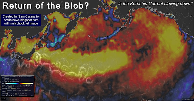
The Blob is a large mass of water with relatively high heat content, floating at the surface and underneath the surface of the North Pacific Ocean. The Blob did appear several times before, including in 2016, which was a strong El Niño year. The above image shows high sea surface temperature anomalies in the North Pacific on August 10, 2023, raising the question of whether this constitutes a return of the Blob.
As temperatures rise, the Arctic is heating more rapidly than the rest of the world. The narrowing temperature difference between the Arctic and the Tropics is weakening the speed at which the jet stream circumnavigates Earth and this is making the jet stream more wavy.
In a 2012 study, Jennifer Francis et al. warned that this makes atmospheric blocking events in the Northern Hemisphere more likely, aggravating extreme weather events related to stagnant weather conditions, such as droughts, flooding and heatwaves. The Blob appears to be the marine version of a heatwave on land.
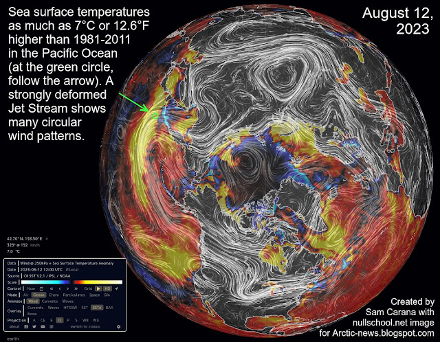
The image below shows that, on August 12, 2023, sea surface temperatures were as much as 7°C or 12.6°F higher than 1981-2011 in the Pacific Ocean (at the green circle, follow the arrow). A strongly deformed Jet Stream shows many circular wind patterns, prolonging, intensifying and increasing the occurrence of extreme weather events such as accumulation of heat during heatwaves.
Is the Kuroshio Current slowing down?
The Kuroshio Current is an ocean current that carries heat along its path in the North Pacific, similar to the Gulf Stream in the North Atlantic Ocean. Is the Kuroshio Current slowing down as temperatures rise and is such slowing down causing hot water to accumulate in the western part of the North Pacific, leading to a return of a new Blob moving across the North Pacific toward the coast of North America?
A deformed Jet Stream, in combination with a cyclone, could result in strong winds abruptly pushing a huge amount of heat through the Bering Strait into the Arctic Ocean. This could cause methane hydrates to destabilize and huge amounts of methane to erupt from the seafloor and enter the atmosphere.
Conclusion
The situation is dire and is getting more dire every day, which calls for a Climate Emergency Declaration and implementation of comprehensive and effective action, as described in the Climate Plan with an update at Transforming Society.
Links
• Evidence Linking Arctic Amplification to Extreme Weather in Mid-Latitudes, by Jennifer Francis et al. (2012)
The Kuroshio Current is an ocean current that carries heat along its path in the North Pacific, similar to the Gulf Stream in the North Atlantic Ocean. Is the Kuroshio Current slowing down as temperatures rise and is such slowing down causing hot water to accumulate in the western part of the North Pacific, leading to a return of a new Blob moving across the North Pacific toward the coast of North America?
The North Atlantic has been experiencing record high sea surface temperatures recently. A return of the Blob increases the danger of more heat reaching sediments at the seafloor of the Arctic Ocean.
The animation on the right shows how remnants of Typhoon Merbok were forecast to enter the Arctic Ocean through the Bering Strait from September 17 to 19, 2022.
Studies, some of them dating back more than two decades, show that over the shallow East Siberian Arctic Shelf (ESAS) winds at times can mix the water column from the top to the bottom. A 2005 study of the ESAS led by Igor Semiletov recorded water temperatures at the seafloor, in September 2000, of 4.7°C at 20m depth at one location and 2.11°C at 41m depth at another location, with salinity levels of 29.7‰ and of 31.7‰, respectively.
A deformed Jet Stream, in combination with a cyclone, could result in strong winds abruptly pushing a huge amount of heat through the Bering Strait into the Arctic Ocean. This could cause methane hydrates to destabilize and huge amounts of methane to erupt from the seafloor and enter the atmosphere.
Conclusion
The situation is dire and is getting more dire every day, which calls for a Climate Emergency Declaration and implementation of comprehensive and effective action, as described in the Climate Plan with an update at Transforming Society.
Links
• The Blob
https://agupubs.onlinelibrary.wiley.com/doi/full/10.1029/2012GL051000
• Record high North Atlantic sea surface temperature
• The East Siberian Sea as a transition zone between Pacific-derived waters and Arctic shelf waters - by Igor Semiletov et al. (2005)
https://agupubs.onlinelibrary.wiley.com/doi/10.1029/2005GL022490
• Climate Plan
https://arctic-news.blogspot.com/p/climateplan.html
• Transforming Society
https://arctic-news.blogspot.com/2022/10/transforming-society.html
• Climate Emergency Declaration
https://arctic-news.blogspot.com/p/climate-emergency-declaration.html
• The Kuroshio current
https://en.wikipedia.org/wiki/Kuroshio_Current
• Remnants of Typhoon Merbok forecast to enter the Arctic Ocean through the Bering Strait from September 17 to 19, 2022.
Discussed at https://www.facebook.com/SamCarana/posts/10166948876390161, from:
https://arctic-news.blogspot.com/p/cold-freshwater-lid-on-north-atlantic.html
https://arctic-news.blogspot.com/p/cold-freshwater-lid-on-north-atlantic.html
• The East Siberian Sea as a transition zone between Pacific-derived waters and Arctic shelf waters - by Igor Semiletov et al. (2005)
https://agupubs.onlinelibrary.wiley.com/doi/10.1029/2005GL022490
https://arctic-news.blogspot.com/p/climateplan.html
• Transforming Society
https://arctic-news.blogspot.com/2022/10/transforming-society.html
• Climate Emergency Declaration
https://arctic-news.blogspot.com/p/climate-emergency-declaration.html


