Showing posts with label Arctic Ocean. Show all posts

Thursday, September 18, 2014

Warm water flowing into Arctic Ocean

by Harold Hensel

For the first time in thousands of years, warm water is flowing into the Arctic Ocean. Warm water from the deep ocean is showing up on surface images. There is no way to put this into the context of 'normal.' Historic temperatures have kept the Arctic frozen on an even keel for thousands of years. Even if there was a 'natural cycle' it has been completely overridden by the astonishing amount of pollution that is going into the atmosphere.


Over 90 percent of Earth's energy imbalance has been going into the oceans, almost unnoticed by people keeping track of the temperatures in the atmosphere. The warmer ocean water is going through the Bering Strait and into the Chukchi Sea, Barents Sea, East Siberian Sea and worst of all, the Laptev Sea.

The Gakkel Ridge crosses the Arctic Ocean from Greenland to the Laptev Sea, see earlier post
There are methane hydrate concentrations in all of these areas up to 1,500 feet deep for miles and miles. There are fractures here that give mantel methane a route to the surface that have been safely sealed by ice. The hydrates and seals are thawing.

In 2013, huge amounts of methane erupted over the Gakkel Ridge and
the Laptev Sea
in October, with levels as high as 2662 ppb on November 9.
In 2014, levels over 2400 ppb were recorded on September 14, 15 and 16.

On the Greenland side, warm water is flowing into the Arctic from the Labrador, Greenland and Norway seas. The international SWERUSs-C3 expedition on the icebreaker Oden is recording 'mega flares' of methane. There are many factors involved in warming the Arctic Ocean, but warm water flowing into it is one of the worst.

Harold Hensel
Cedar Rapids

Monday, July 21, 2014

Methane rising through fractures

by Harold Hensel


Methane is colorless and odorless and it is right above us in the atmosphere.

In addition to other sources, methane has traveled from the Arctic and has blanketed most of the Northern Hemisphere.

The well-known sources are methane hydrates from the Arctic Ocean floor and methane coming from thawing permafrost.

There is also another less well-known source. During the geologic history of the Arctic area, tectonic plates have spread, crashed into each other and subducted under one another. Geologists call the Arctic a tectonic plate junkyard. There are numerous fractures in the earth's crust there.

A quote from earth scientist Malcolm Light: ‘Mantle methane formed from the reduction of oceanic carbonates by water in the presence of iron (II) oxides buried to depths of 100 km to 300 km in the Asthenosphere and at temperatures above 1200°C.’ This is a nonorganic source of methane formed near the earth's mantel. Katey Walter Anthony from the University of Alaska calls it geologic methane.

Vast reservoirs of methane have been created by chemical reactions and stored near the mantle under a lot of pressure for millennia.

The methane has had a route to the surface through the fractures in the earth's crust, but the fractures have been sealed over by ice. Now for the first time in human history, the ice sealing the fractures is thawing. Methane is rising through the fractures and into the atmo­sphere. This methane has migrated to the United States and is over us.


Harold Hensel, 
Cedar Rapids.
Earlier published as 
Letter to the Editor 
Cedar Rapids Gazette 
(without images)


Related

- Study: Geologic methane seeping from thawing cryosphere - by Marmian Grimes
http://uafcornerstone.net/study-geologic-methane-seeping-from-thawing-cryosphere

- Focus on Methane - by Malcolm Light
http://arctic-news.blogspot.com/2014/07/focus-on-methane.html

- Arctic Atmospheric Methane Global Warming Veil - by Malcolm Light, Harold Hensel and Sam Carana

- Mantle Methane - by Malcolm Light


Tuesday, November 5, 2013

Methane, Faults and Sea Ice

Shield breaking down

Until now, Arctic sea ice has been acting as a shield, in a number of ways, including:
  • preventing sunlight from warming up water underneath the sea ice 
  • facilitating currents that currently cool the bottom of the sea
  • preventing much methane from entering the atmosphere; as discussed in an earlier post, the sea ice collects and holds the methane in places close enough to the surface for the methane to be consumed through photochemical and biochemical oxidation. 
However, as the sea ice declines, this shield is breaking down. As a result:
  • more sunlight is reaching the water, contributing to warming of water in the Arctic Ocean
  • sea ice decline comes with the danger of weakened currents that cool the seabed
  • more methane is able to penetrate the cracks and openings in the ever-thinner ice. 
Warm Water traveling along Gulf Stream

At the same time, global warming is causing more extreme weather events to occur, such as the record warmth observed in July 2013 in part of the northeastern Atlantic Ocean off the coast of North America. As discussed in a recent post, this warm water has meanwhile traveled along the Gulf Stream and reached the Arctic Ocean.

Methane venting from Seabed

As a result, warmer water is now destabilizing sediments under the seabed that hold huge amounts of methane in the form of free gas and hydrates. Methane is now venting from the seabed of the Arctic Ocean, driven by sea ice decline and "by Gulf Stream heating, earthquakes and deep pyroclastic eruptions", as Malcolm Light explains in a recent comment and as described in an earlier post.

The image below shows the result: Massive amounts of methane venting from the seabed, penetrating the sea ice, and entering the atmosphere over the Arctic Ocean. 


Methane, Faults and Sea Ice

The animation below illustrates links between: 
  • The fault line that crosses the Arctic Ocean and forms the boundery between two tectonic plates (i.e. the North American Plate and the Eurasian Plate)
  • Arctic sea ice, which until now has acted as a shield
  • The prominence of high methane readings over the Arctic Ocean 

Saturday, November 2, 2013

Locating sources of the world's highest methane levels


Above image shows IASI methane readings end October 2013 on the Northern Hemisphere. Clearly, high methane levels are very prominent over the Arctic. Over this period, the following peak methane readings have been recorded:
- October 28 - 2369 ppb
- October 29 - 2303 ppb
- October 30 - 2480 ppb
- October 31 - 2332 ppb

[ click on image to enlarge ]
Above image shows methane readings of 1950 ppb and higher in yellow, but only on October 31, 2013, pm.

This image is easier to analyze, since there are only a few areas where high methane readings show up, such as:
  • Last but not least, there's a huge area with high methane readings over the Arctic Ocean.
The image below again shows methane readings of 1950 ppb and higher in yellow on October 31, 2013, pm, but this time only for 3 altitudes, i.e. 451 mb, 469 mb and 487 mb. These levels were selected for their proximity to the altitude of 469 mb, where typically the highest mean global methane levels are recorded, i.e. from 1809 ppb to 1812 ppb for the period from October 28 to 31, 2013. Not surprisingly, the image below looks much the same as above image.


Things look rather different, though, when 3 altitudes are selected closer to sea level. The image below again shows methane readings of 1950 ppb and higher in yellow on October 31, 2013, pm, but this time only at 718 mb, 742 mb and 766 mb. These altitudes showed the highest methane readings that day, of 2322 ppb, 2332 ppb and 2316 ppb, respectively.


Ominously, high methane readings at these lower altitudes show up mostly in the Laptev Sea. In conclusion, some of the world's highest methane levels show up over the Laptev Sea, a huge area most prone to abrupt release of huge amounts of methane from the seabed.

This is further evidence in support of the looming threat of Abrupt Climate Change leading to extinction of many if not all species (i.e. including humans) within decades. It disproves the efforts of the IPCC, as discussed in the post Just do NOT tell them the monster exists, and further organizations to downplay the threat by spreading myths.

Monday, October 28, 2013

Methane over Arctic Ocean is increasing


[ click on image to enlarge ]

Above image shows the Northern Hemisphere on October 26 - 27, 2013, a period of just over one day. Methane readings of 1950 ppb and higher show up in yellow. Peak reading on October 27, 2013, was 2369 ppb.

The image below, created by Harold Hensel with methanetracker, shows methane over the Arctic Ocean in three ranges, with the highest readings (1950 ppb and higher) in red.

[ click on image to enlarge ]
Harold adds: "Methane increased again in the Arctic Circle yesterday, 10/27/2013. So what were the headlines in the news? It wasn't this which is more important than anything the media has to report. This is surreal to me." - at Facebook

Related

- The Unfolding Methane Catastrophe
http://arctic-news.blogspot.com/2013/10/unfolding-methane-catastrophe.html

- Methane hydrates
http://methane-hydrates.blogspot.com/2013/04/methane-hydrates.html

- Myths about methane hydrates
http://methane-hydrates.blogspot.com/p/myths.html

- High Methane Readings continue over Depth of Arctic Ocean
http://arctic-news.blogspot.com/2013/10/high-methane-readings-continue-over-depth-of-arctic-ocean.html

- Abrupt Climate Change
http://arctic-news.blogspot.com/2013/10/abrupt-climate-change.html

- Just do NOT tell them the monster exists
http://arctic-news.blogspot.com/2013/10/just-do-not-tell-them-the-monster-exists.html


Monday, October 21, 2013

High Methane Levels over Laptev Sea

A major fault line crosses the Arctic Ocean, forming the boundery between two tectonic plates, the North American Plate and the Eurasian Plate. These plates slowly diverge, creating seismic tension along the fault line.


From where the Mid-Atlantic ridge enters the Arctic Ocean, it is called the Gakkel Ridge. The fault continues as the Laptev Sea Rift, on to a transitional deformation zone in the Chersky Range in Siberia, then the Ulakhan Fault between the North American Plate and the Okhotsk Plate, and then continues as the Aleutian Trench to the end of the Queen Charlotte Fault system.


Above map shows the location of some of the main points of interest, i.e. the Laptev Sea Rift and the Gakkel Ridge, where high methane readings have been recorded recently, as shown in the image below. Indicated in yellow are all methane readings of 1950 ppb and over, for a period of just over one day, October 19 - 20, 2013.  


To pointpoint more closely where methane is venting along the Laptev Sea Rift, the image below gives readings for October 20, 2013, pm, at just three altitudes (607 - 650 mb). 


This is a very dangerous situation, since high levels of methane have been recorded over the Arctic Ocean for more than a month now. Furthermore, large amounts of methane have vented in the Laptev Sea area in previous years. Added below is an edited part of a previous post, Unfolding Climate Catastrophe

In September 2005, extremely high concentrations of methane (over 8000 ppb, see image on the right) were measured in the atmospheric layer above the sea surface of the East Siberian Shelf, along with anomalously high concentrations of dissolved methane in the water column (up to 560 nM, or 12000% of super saturation).

The authors conclude: "Since the area of geological disjunctives (fault zones, tectonically and seismically active areas) within the Siberian Arctic shelf composes not less than 1-2% of the total area and area of open taliks (area of melt through permafrost), acting as a pathway for methane escape within the Siberian Arctic shelf reaches up to 5-10% of the total area, we consider release of up to 50 Gt of predicted amount of hydrate storage as highly possible for abrupt release at any time".

In 2007, concentrations of dissolved methane in the water column reached a level of over 5141 nM at a location in the Laptev Sea. For more background, see the previous post, Unfolding Climate Catastrophe

Satellite measurements show methane readings of up to 2411 ppb on October 20, 2013. Sadly, no current data are available from measurements in the Laptev Sea, neither methane levels in the water, nor atmospheric methane levels just above sea level. Perhaps in time, some data will become available from expeditions.


Sunday, October 6, 2013

Just do NOT tell them the monster exists

The Arctic Methane Monster

As discussed in a previous post, the IPCC appears to be acting as if there was a carbon budget to divide among countries, whereas in reality there is a huge carbon debt to our children, while the situation could become catastrophic any time soon.

Indeed, carbon dioxide is not the only greenhouse gas and the Arctic methane monster is threatening to disrupt the cosy lifetyle of those who want to keep selling parts of such non-existing carbon budgets.

So, who do you think the IPCC has been listening to, to reach a conclusion after six years of analysis? Experts or snake oil sellers? The cartoon may give you a hint, but why don't you make up your own mind by going over the IPCC statements and comments below.

Abrupt Climate Change

The IPCC recently issued AR5 documents that included a discussion of Abrupt Climate Change.

from: IPCC AR5 Working Group 1 Technical Summary (final draft)
The IPCC gives some examples:


Yes, methane release from clathrates sounds scary.


If there is little consensus on the likelihood, then surely some experts do believe it is likely. Yet, the IPCC somehow reaches the following conclusion, and does so with high confidence:


Unlikely? What was the basis for this IPCC conclusion? 

This seems like a conclusion that can only have been reached after a robust analysis of all the evidence. So, how did the IPCC reach this conclusion, given that it did so with such high confidence?

Let's have a look. The above conclusion is preceeded by this statement:


OK, that means clathrates will increasingly become destabilized. The IPCC then adds an argument why this would not result in abrupt climate change this century.


Sure, but that's just one rather insignificant negative feedback, compared to the many more significant positive feedbacks, such as melting causing isostatic rebound that can contribute to the occurrence of earthquakes and landslides, in turn triggering methane release. Yet, without even mentioning these positive feedbacks, the paragraph then jumps to the following conclusion:


If these initial estimates are not insignificant and if it's all rather difficult to formally assess, how then is it possible that the IPCC reached its end-conclusion with such high confidence? Moreover, was there any basis for these "initial estimates"? Perhaps there's more elsewhere in the IPCC documents. Here's another paragraph that preceeded the above.


All this expresses is low confidence in existing modeling and lack of understanding of the various processes. Again, how then is it possible that the IPCC reached its conclusion with such high confidence?

How much methane is currently released from hydrates?

On this, the IPCC says:


OK, so things could become scary. And sure, there are no large abrupt releases taking place now, but that doesn't mean there's not going to be any in future. In case of gradual processes, it makes sense to base projections on historic releases. In case of abrupt releases, however, current releases should not be the basis for reaching a conclusion with high confidence.

So, was the work of Dr. Natalia Shakhova perhaps used as the basis for these estimates? Read on!

How much methane is stored under the Arctic Ocean?

How much methane is present in sediments under the seabed of the Arctic Ocean, in the form of free gas and hydrates? On this, the IPCC says in FAQ6:


That doesn't seem to reflect the estimates of Dr. Natalia Shakhova. According to older estimates, the total amount of methane in the atmosphere is about 5 Gt. Saying that more than 50 Gt of methane could be stored in hydrates the Arctic seems deceptive and appears to be seriously downplaying a very dangerous situation.

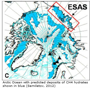
Natalia Shakhova et al. in 2010 estimated the accumulated potential for the East Siberian Arctic Shelf (ESAS) region alone (image on the right) as follows:
  • organic carbon in permafrost of about 500 Gt
  • about 1000 Gt in hydrate deposits
  • about 700 Gt in free gas beneath the gas hydrate stability zone.
Back in 2008, Natalia Shakhova et al. considered release of up to 50 Gt of predicted amount of hydrate storage as highly possible for abrupt release at any time. Did the IPCC perhaps misread the figures, mistaking the part of the methane that is ready for abrupt release for the total amount of methane in the Arctic?

How long could it take for large amounts of methane to reach the atmosphere?

How long could it take for large amounts to reach the atmosphere? On this, the IPCC says in FAQ6, in the same and the next paragraph:


Events in which most, if not virtually all methane that escaped from the seabed did enter the atmosphere have been studied in 2002 and published in 2006, as reported at:
http://www.ia.ucsb.edu/pa/display.aspx?pkey=1482
and at:
http://onlinelibrary.wiley.com/doi/10.1029/2005GB002668/abstract

Below, a screenshot from an interview of John Mason with Natalia Shakhova, published at:
http://www.skepticalscience.com/arctic-methane-outgassing-e-siberian-shelf-part2.html


In conclusion, Dr Natalia Shakhova also rejects the idea that methane release from hydrates always takes place gradually, over a long time. Especially in the Arctic, there's a huge danger of abrupt release, given the accelerated warming that takes place in the Arctic, given the huge amounts of methane stored in sediments in the form of free gas and methane, given the presence of a tectonic fault line, etc, etc.

Once released, methane won't get broken down easily in the Arctic Ocean, as this requires the presence of bacteria that can oxidize the methane, as well as free oxygen in the water. Once depleted, oxygen isn't quickly replenished in the Arctic Ocean. Lack of bacteria and depletion of oxygen in the waters of the Arctic Ocean could prevent oxidation of methane rising up in the waters, as described at:
http://methane-hydrates.blogspot.com/2012/03/large-areas-of-open-ocean-starved-of.html

In the Arctic, low temperatures mean there are less bacteria that need more time to break down the methane. In other places, currents may bring bacteria back to the location of the methane plume repeatedly. In the Arctic, many currents are long, so once bacteria have flowed away from the location of the plume, they could be driven out of the Arctic Ocean or may return only after a long time, i.e. too long to survive in Arctic waters which are cold and often ice-covered, so a lot of time little or no sunshine penetrates the waters.

In the Arctic, the danger is much larger that methane releases will overwhelm the capacity of bacteria to break it down in the water. In case of large abrupt releases in the Arctic, the danger is that much of the methane will reach the atmosphere unaffected and remain there for a long time, due to the Jet Stream and the low levels of hydroxyl in the Arctic atmosphere, as further described at:
http://methane-hydrates.blogspot.com/2013/04/methane-hydrates.html

BTW, how did all this methane manage to reach the atmosphere over the Arctic Ocean? 

Methane levels over the Arcic Ocean appear to be rising, as illustrated by the combination of images below, showing methane levels over five years (2009 on the left, to 2013 on the right), each time for the same period (January 21-31) - images by Dr. Leonid Yurganov.

[ Click on image to enlarge - from: Dramatic increase in methane in the Arctic in January 2013 ]
If the IPCC was right, how then was it possible methane levels to rise so sharply and abruptly. How was it possible for large amounts of methane to be present over the deep waters of the Arctic Ocean, as discussed at:
http://arctic-news.blogspot.com/2013/10/methane-over-deep-waters-of-arctic-ocean.html

[ How did this methane get there? - click on image to enlarge - see also: Methane over deep waters of Arctic Ocean ]
There is a wealth of evidence from scientists such as Igor Semiletov and Natalia Shakhova who have - year after year - been taking measurements in the East Siberian Arctic Shelf, complete with first-hand reports that methane plumes have been detected.

"We've found continuous, powerful and impressive seeping structures more than 1,000 metres in diameter. In a very small area, less than 10,000 square miles, we have counted more than 100 fountains, or torch-like structures, bubbling through the water column and injected directly into the atmosphere from the seabed," Dr Semiletov said, "We carried out checks at about 115 stationary points and discovered methane fields of a fantastic scale - I think on a scale not seen before. Some of the plumes were a kilometre or more wide and the emissions went directly into the atmosphere - the concentration was a hundred times higher than normal."  -  Vast methane 'plumes' seen in Arctic ocean as sea ice retreats, by Steve Connor in The Independent, December 13, 2011.

The image below shows a cluster of methane plumes, over one km in diameter, that appeared in the Laptev Sea end September 2011. The image is part of a paper on the unfolding "Methane Catastrophe".


Of course, we all wished that we're wrong about this terrifying Arctic methane threat, but the precautionary principle demands a thorough investigation of observations that appear to be at odds with wishful thinking, especially when the stakes are so high. So, IPCC, where's the evidence?


Related

- Arctic Methane Monster
http://arctic-news.blogspot.com/2013/09/arctic-methane-monster.html

- Methane over deep waters of Arctic Ocean
http://arctic-news.blogspot.com/2013/10/methane-over-deep-waters-of-arctic-ocean.html

- Methane hydrate myths
http://methane-hydrates.blogspot.com/p/myths.html

- Methane hydrates
http://methane-hydrates.blogspot.com/2013/04/methane-hydrates.html

- Methane release caused by earthquakes
http://arctic-news.blogspot.com/2013/09/methane-release-caused-by-earthquakes.html

- Earthquake hits Laptev Sea
http://arctic-news.blogspot.com/2013/09/earthquake-hits-laptev-sea.html

- North Hole
http://arctic-news.blogspot.com/2013/09/north-hole.html

- Seismic activity, by Malcolm Light and Sam Carana (2011)
Arctic-news.blogspot.com/p/seismic-activity.html

- Thermal expansion of the Earth's crust necessitates geoengineering (2011)
Arctic-news.blogspot.com/p/thermal-expansion.html

Saturday, October 5, 2013

Methane over deep waters of Arctic Ocean

The image below shows a lot of methane over deeper parts of oceans, in particular the Arctic Ocean.

[ click on image to enlarge ]
Let's zoom in and take a closer look at what's happening.

[ click on image to enlarge ]
As earlier discussed in the post Methane release caused by earthquakes, there has been a lot of seismic activity in the Aleutian Islands region all the way up into Alaska, including an earthquake with a magnitude of 7 on the Richter scale on August 30, 2013, and several more recent earthquakes with a higher magnitude than 6 on the Richter scale.

An earthquake with a magnitude of 4.6 on the Richter scale hit the Laptev Sea on September 28, 2013. Furthermore, there have been several earthquakes in Siberia, while an earthquake with a magnitude of 6.7 on the Richter scale recently hit the Sea of Okhotsk, which occurred at a depth of 359.3 miles (578.24 km). Earthquakes at such a depth can be felt at great distances from the epicenter and can destabilize methane hydrates.

The presence of methane over the deeper parts of the Arctic Ocean has been discussed in a number of post at this blog recently (see under related, below). It should serve as a warning to those who believed that all methane escaping from deep-sea hydrates would be oxidized in the water by microbes before entering the atmosphere.

The IPCC appears to still close its eyes for such scenarios. Look at this screenshot from IPCC AR5 WGI TS.3.7:

Low release this century? Well, the danger may seem low now in many places, but the situation is already very dangerous in the Arctic, where hydroxyl levels in the atmosphere are very low, where water temperatures can show huge anomalies and where seas can be very shallow and at times become super-saturated with methane, to the extent that oxygen depletion in the water prevents methane oxidation. In the case of large abrupt release, waters will soon become super-saturated with methane locally, especially in the shallow parts of the Arctic Ocean. Furthermore, low sea temperatures and the peculiarities of currents create conditions in the Arctic Ocean that are not beneficial to the kind of growth of microbes that would decompose methane in oceans elsewhere.

How much methane are we talking about? One look at the top image shows that there's a huge amount of methane over the Arctic Ocean. On October 3, 2013, a peak reading was recorded of 2283 ppb and that wasn't even the highest recent reading, as illustrated by the graph below.


Where were these large amounts of methane released? The animation below shows methane methane readings of over 1950 ppb on October 3, 2013, on the afternoon only and with readings at only four relatively low altitudes, with methane over the Arctic Ocean dominating the picture.

Tuesday, August 13, 2013

Arctic Ocean is turning red

The Arctic Ocean is turning red, as sea surface temperatures (SST) rise. The NOAA maps below, dated August 12, 2013, show sea surface temperature anomalies across the Arctic Ocean of up to 5°C (9°F). Virtually all areas were the sea ice has disappeared are now colored scarlet red.

[ click on image to enlarge ]
The (updated) animation below shows SST anomalies from June 3 to August 26, 2013.


For a full-size animation, see http://www.ospo.noaa.gov/Products/ocean/sst/anomaly/anim_full.html

Locally, the situation can be even worse. The NOAA map below, dated August 13, 2013, shows that areas where the sea ice has disappeared in the Arctic Ocean can be exposed to sea surface temperature anomalies higher than 8°C (14.4°F).


[ click on image to enlarge ]
These anomalies are very high, even when compared to some of the recent years, when the decline of sea ice extent didn't look as bad as it appears now.

Many people may only look at the sea ice, assuming that things are fine as long as there is no dramatic decrease in sea ice area or extent (see Cryosphere Today image right).

However, there are many other things to consider, as described in the earlier post Cyclone raging over thin ice. Most importantly, sea surface temperature anomalies this high are very alarming!

For comparison, the image below shows August sea surface temperature anomalies in 2007, 2010 and 1011.

from: http://www.arctic.noaa.gov/reportcard/ocean.html
These high sea surface temperature anomalies are firstly caused by higher sea and air temperatures as a result of global warming. Additionally, there are many feedbacks that accelerate the temperature rise in the Arctic, as discussed at the post Diagram of Doom. Local conditions can further accelerate the temperature rise in specific areas, such as where warm water from rivers flows into the Arctic Ocean.

As the map below shows, a number of large rivers end in the Kara Sea, where high temperatures have been recorded for some time.

map from: http://en.wikipedia.org/wiki/File:Rs-map.png
Another large river is the Mackenzie River, which ends in the Beaufort Sea, where sea surface temperatures of about 20°C (68°F) are currently recorded, as the image below illustrates.


Similarly, the NOAA image below shows that sea surface temperatures of up to 18°C (64.4°F) were recorded in the Bering Strait on August 12, 2013.


Note that the melting season still has quite a while to go. Arctic sea ice volume minimum is typically reached around halfway into September, which is more than one month away. On September 12-13, 2011, temperatures of 6-7°C were reached over East Siberian Arctic Shelf, and up to 9°C along the coast of Alaska.

The danger of this situation is that this dramatic rise in temperature anomalies will not remain restricted to surface waters, but that heat will penetrate the seabed which can contain huge amounts of methane in the form of hydrates and free gas in sediments.

Submarine pingoes: Indicators of shallow gas
hydrates in a pockmark at Nyegga, Norwegian Sea -
Hovland et al., Marine Geology 228 (2006) 15–23
At the moment, a cyclone is raging over the Arctic Ocean, and this causes warm surface waters to be mixed down, in many places all the way down to the seabed, due to the shallow nature of many of the seas in the Arctic Ocean.

As shown on the image right and also described at the FAQ page, there can be all kinds of fractures in the sediment, while there can also be conduits where methane has escaped earlier from hydrates, allowing heat to penetrate deep into the sediment and causing methane to escape.

Methane is kept stable inside hydrates as long as the temperature remains low. Since methane expand some 160 times in volume, compared to its compressed frozen state inside the hydrate, warming of even a small part of a hydrate can cause destabilization across the entire hydrate. It may take only a small rise in temperature of a single conduit in the sediment to set off a large abrupt release of methane, which subsequently threatens to cause further releases elsewhere in the Arctic Ocean and trigger runaway global warming, as described at the methane hydrates blog.